
Geography of Sierra Leone
Encyclopedia
Sierra Leone
Sierra Leone , officially the Republic of Sierra Leone, is a country in West Africa. It is bordered by Guinea to the north and east, Liberia to the southeast, and the Atlantic Ocean to the west and southwest. Sierra Leone covers a total area of and has an estimated population between 5.4 and 6.4...
is located on the west
West Africa
West Africa or Western Africa is the westernmost region of the African continent. Geopolitically, the UN definition of Western Africa includes the following 16 countries and an area of approximately 5 million square km:-Flags of West Africa:...
coast of Africa
Africa
Africa is the world's second largest and second most populous continent, after Asia. At about 30.2 million km² including adjacent islands, it covers 6% of the Earth's total surface area and 20.4% of the total land area...
, between the 7th
7th parallel north
The 7th parallel north is a circle of latitude that is 7 degrees north of the Earth's equatorial plane. It crosses Africa, the Indian Ocean, South Asia, Southeast Asia, the Pacific Ocean, South America and the Atlantic Ocean....
and 10th parallels
10th parallel north
The 10th parallel north is a circle of latitude that is 10 degrees north of the Earth's equatorial plane. It crosses Africa, the Indian Ocean, South Asia, Southeast Asia, the Pacific Ocean, Central America, South America and the Atlantic Ocean....
north of the equator
Equator
An equator is the intersection of a sphere's surface with the plane perpendicular to the sphere's axis of rotation and containing the sphere's center of mass....
. Sierra Leone is bordered by Guinea
Guinea
Guinea , officially the Republic of Guinea , is a country in West Africa. Formerly known as French Guinea , it is today sometimes called Guinea-Conakry to distinguish it from its neighbour Guinea-Bissau. Guinea is divided into eight administrative regions and subdivided into thirty-three prefectures...
to the north and northeast, Liberia
Liberia
Liberia , officially the Republic of Liberia, is a country in West Africa. It is bordered by Sierra Leone on the west, Guinea on the north and Côte d'Ivoire on the east. Liberia's coastline is composed of mostly mangrove forests while the more sparsely populated inland consists of forests that open...
to the south and southeast, and the Atlantic Ocean
Atlantic Ocean
The Atlantic Ocean is the second-largest of the world's oceanic divisions. With a total area of about , it covers approximately 20% of the Earth's surface and about 26% of its water surface area...
to the west. The country has a total area of 71740 km² (27,699 sq mi), divided into a land area of 71620 km² (27,653 sq mi) and water of 120 km² (46 sq mi). The country has four distinct geographical regions: coastal Guinean mangroves
Guinean mangroves
The Guinean mangroves are a coastal ecoregion of mangrove swamps in rivers and estuaries near the ocean of West Africa from Senegal to Sierra Leone.-Location and description:...
, the wooded hill country, an upland plateau
Plateau
In geology and earth science, a plateau , also called a high plain or tableland, is an area of highland, usually consisting of relatively flat terrain. A highly eroded plateau is called a dissected plateau...
, and the eastern mountains. Eastern Sierra Leone is an interior region of large plateaus interspersed with high mountains, where Mount Bintumani
Mount Bintumani
Mount Bintumani is the highest peak in Sierra Leone, at . It lies in the Loma Mountains and its lower slopes are covered in rainforests, home to a wide variety of animals. These include Pygmy Hippopotamuses, dwarf crocodiles, Rufous Fishing-owls and numerous primates....
rises to 1948 metres (6,391 ft).
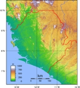
Physical geography
Sierra Leone is located on the westWest Africa
West Africa or Western Africa is the westernmost region of the African continent. Geopolitically, the UN definition of Western Africa includes the following 16 countries and an area of approximately 5 million square km:-Flags of West Africa:...
coast of Africa
Africa
Africa is the world's second largest and second most populous continent, after Asia. At about 30.2 million km² including adjacent islands, it covers 6% of the Earth's total surface area and 20.4% of the total land area...
, between the 7th
7th parallel north
The 7th parallel north is a circle of latitude that is 7 degrees north of the Earth's equatorial plane. It crosses Africa, the Indian Ocean, South Asia, Southeast Asia, the Pacific Ocean, South America and the Atlantic Ocean....
and 10th parallels
10th parallel north
The 10th parallel north is a circle of latitude that is 10 degrees north of the Earth's equatorial plane. It crosses Africa, the Indian Ocean, South Asia, Southeast Asia, the Pacific Ocean, Central America, South America and the Atlantic Ocean....
north of the equator
Equator
An equator is the intersection of a sphere's surface with the plane perpendicular to the sphere's axis of rotation and containing the sphere's center of mass....
. Sierra Leone is bordered by Guinea
Guinea
Guinea , officially the Republic of Guinea , is a country in West Africa. Formerly known as French Guinea , it is today sometimes called Guinea-Conakry to distinguish it from its neighbour Guinea-Bissau. Guinea is divided into eight administrative regions and subdivided into thirty-three prefectures...
to the north and northeast, Liberia
Liberia
Liberia , officially the Republic of Liberia, is a country in West Africa. It is bordered by Sierra Leone on the west, Guinea on the north and Côte d'Ivoire on the east. Liberia's coastline is composed of mostly mangrove forests while the more sparsely populated inland consists of forests that open...
to the south and southeast, and the Atlantic Ocean
Atlantic Ocean
The Atlantic Ocean is the second-largest of the world's oceanic divisions. With a total area of about , it covers approximately 20% of the Earth's surface and about 26% of its water surface area...
to the west. The country has a total area of 71740 km² (27,699 sq mi), divided into a land area of 71620 km² (27,653 sq mi) and water of 120 km² (46 sq mi). The country has four distinct geographical regions: coastal Guinean mangroves
Guinean mangroves
The Guinean mangroves are a coastal ecoregion of mangrove swamps in rivers and estuaries near the ocean of West Africa from Senegal to Sierra Leone.-Location and description:...
, the wooded hill country, an upland plateau
Plateau
In geology and earth science, a plateau , also called a high plain or tableland, is an area of highland, usually consisting of relatively flat terrain. A highly eroded plateau is called a dissected plateau...
, and the eastern mountains. Eastern Sierra Leone is an interior region of large plateaus interspersed with high mountains, where Mount Bintumani
Mount Bintumani
Mount Bintumani is the highest peak in Sierra Leone, at . It lies in the Loma Mountains and its lower slopes are covered in rainforests, home to a wide variety of animals. These include Pygmy Hippopotamuses, dwarf crocodiles, Rufous Fishing-owls and numerous primates....
rises to 1948 metres (6,391 ft).
Geology
Sierra Leone can be split into three geological areas, in the east is part of the West African cratonWest African craton
The West African craton is one of the five large masses, or cratons, of the Precambrian basement rock of Africa that make up the African Plate, the others being the Kalahari craton, Congo craton, Saharan Metacraton and Tanzania craton. These land masses came together in the late Precambrian and...
, the western area consists is the Rokelides, an orogenic belt, and a 20 to 30 km coastal strip of sediment
Sediment
Sediment is naturally occurring material that is broken down by processes of weathering and erosion, and is subsequently transported by the action of fluids such as wind, water, or ice, and/or by the force of gravity acting on the particle itself....
s.
Extreme points
This is a list of the extreme points of Sierra LeoneSierra Leone
Sierra Leone , officially the Republic of Sierra Leone, is a country in West Africa. It is bordered by Guinea to the north and east, Liberia to the southeast, and the Atlantic Ocean to the west and southwest. Sierra Leone covers a total area of and has an estimated population between 5.4 and 6.4...
, the points that are farther north, south, east or west than any other location.
- Northern-most point – the northern section of the border with GuineaGuineaGuinea , officially the Republic of Guinea , is a country in West Africa. Formerly known as French Guinea , it is today sometimes called Guinea-Conakry to distinguish it from its neighbour Guinea-Bissau. Guinea is divided into eight administrative regions and subdivided into thirty-three prefectures...
, Northern ProvinceNorthern Province, Sierra LeoneThe Northern Province is one of the four provincial divisions of Sierra Leone. It comprises five Districts and covers an area of 35,936 km² and with a population of 1,718,240 . Its administrative and economic center is Makeni...
* - Eastern-most point – the tripointTripointA tripoint, or trijunction , is a geographical point at which the borders of three countries or subnational entities meet....
with GuineaGuineaGuinea , officially the Republic of Guinea , is a country in West Africa. Formerly known as French Guinea , it is today sometimes called Guinea-Conakry to distinguish it from its neighbour Guinea-Bissau. Guinea is divided into eight administrative regions and subdivided into thirty-three prefectures...
and LiberiaLiberiaLiberia , officially the Republic of Liberia, is a country in West Africa. It is bordered by Sierra Leone on the west, Guinea on the north and Côte d'Ivoire on the east. Liberia's coastline is composed of mostly mangrove forests while the more sparsely populated inland consists of forests that open...
, Eastern ProvinceEastern Province, Sierra LeoneEastern Province is one of the four provinces of Sierra Leone. It covers an area of 15,553 km² and has a population of 1,187,532... - Southern-most point – unnamed peninsulaPeninsulaA peninsula is a piece of land that is bordered by water on three sides but connected to mainland. In many Germanic and Celtic languages and also in Baltic, Slavic and Hungarian, peninsulas are called "half-islands"....
south of the town of Mano Salija at the mouth of the Mano RiverMano RiverThe Mano River is a river in west Africa, it originates in the Guinea Highlands in Liberia and forms part of the Liberia – Sierra Leone border....
, Southern ProvinceSouthern Province, Sierra LeoneThe Southern Province is one of three provinces of Sierra Leone. It covers an area of 19,694 km² and has a population of 1,377,067 . It consists of four districts . Its capital and administrative center is Bo, which is also the second largest and second most populated city in Sierra Leone... - Western-most point - the point at which the border with GuineaGuineaGuinea , officially the Republic of Guinea , is a country in West Africa. Formerly known as French Guinea , it is today sometimes called Guinea-Conakry to distinguish it from its neighbour Guinea-Bissau. Guinea is divided into eight administrative regions and subdivided into thirty-three prefectures...
enters the Atlantic OceanAtlantic OceanThe Atlantic Ocean is the second-largest of the world's oceanic divisions. With a total area of about , it covers approximately 20% of the Earth's surface and about 26% of its water surface area...
, Northern ProvinceNorthern Province, Sierra LeoneThe Northern Province is one of the four provincial divisions of Sierra Leone. It comprises five Districts and covers an area of 35,936 km² and with a population of 1,718,240 . Its administrative and economic center is Makeni...
- *Note: Sierra Leone does not have a northern-most point, the border being formed here by 10th parallel north10th parallel northThe 10th parallel north is a circle of latitude that is 10 degrees north of the Earth's equatorial plane. It crosses Africa, the Indian Ocean, South Asia, Southeast Asia, the Pacific Ocean, Central America, South America and the Atlantic Ocean....
Climate
The climateClimate
Climate encompasses the statistics of temperature, humidity, atmospheric pressure, wind, rainfall, atmospheric particle count and other meteorological elemental measurements in a given region over long periods...
is tropical, although it could be classified as a tropical monsoon climate
Tropical monsoon climate
Tropical monsoon climate, occasionally also known as a tropical wet climate or tropical monsoon and trade-wind littoral climate in climate classification, is a relatively rare type of climate that corresponds to the Köppen climate classification category "Am."Tropical monsoon climates have monthly...
it could also be describe as a climate that is transitional between a continually wey tropical rainforest climate
Tropical rainforest climate
A tropical rainforest climate, also known as an equatorial climate, is a tropical climate usually found along the equator...
and a tropical savanna climate
Tropical savanna climate
Tropical savanna climate or tropical wet and dry climate is a type of climate that corresponds to the Köppen climate classification categories "Aw" and '"As."...
. There are two seasons determining the agricultural cycle: the rainy season from May to November, and a dry season
Dry season
The dry season is a term commonly used when describing the weather in the tropics. The weather in the tropics is dominated by the tropical rain belt, which oscillates from the northern to the southern tropics over the course of the year...
from December to May, which includes harmattan
Harmattan
The Harmattan is a dry and dusty West African trade wind. It blows south from the Sahara into the Gulf of Guinea between the end of November and the middle of March...
, when cool, dry winds blow in off the Sahara Desert and the night-time temperature can be as low as 16 °C (60.8 °F). The average temperature is 26 °C (78.8 °F) and varies from around 26 °C (78.8 °F) to 36 °C (96.8 °F) during the year. Average rainfall is highest at the coast, 3000-5000 mm per year, moving inland this decreases and at the eastern border of the country the average rainfall is 2000-2500mm.
Environmental agreements
Sierra Leone is party to several environmental agreements:- BiodiversityConvention on Biological DiversityThe Convention on Biological Diversity , known informally as the Biodiversity Convention, is an international legally binding treaty...
(Convention on Biological Diversity) - Climate ChangeUnited Nations Framework Convention on Climate ChangeThe United Nations Framework Convention on Climate Change is an international environmental treaty produced at the United Nations Conference on Environment and Development , informally known as the Earth Summit, held in Rio de Janeiro from June 3 to 14, 1992...
(United Nations Framework Convention on Climate Change) - DesertificationUnited Nations Convention to Combat DesertificationThe United Nations Convention to Combat Desertification in Those Countries Experiencing Serious Drought and/or Desertification, Particularly in Africa is a Convention to combat desertification and mitigate the effects of drought through national action programs that incorporate long-term strategies...
(United Nations Convention to Combat Desertification) - Endangered Species (CITES)
- Law of the SeaUnited Nations Convention on the Law of the SeaThe United Nations Convention on the Law of the Sea , also called the Law of the Sea Convention or the Law of the Sea treaty, is the international agreement that resulted from the third United Nations Conference on the Law of the Sea , which took place from 1973 through 1982...
(UNCLOS or LOS) - Marine Life ConservationConvention on Fishing and Conservation of Living Resources of the High SeasThe Convention on Fishing and Conservation of Living Resources of the High Seas is an agreement that was designed to solve through international cooperation the problems involved in the conservation of living resources of the high seas, considering that because of the development of modern...
(Convention on Fishing and Conservation of Living Resources of the High Seas) - Nuclear Test BanComprehensive Test Ban TreatyThe Comprehensive Nuclear-Test-Ban Treaty bans all nuclear explosions in all environments, for military or civilian purposes. It was adopted by the United Nations General Assembly on 10 September 1996 but it has not entered into force.-Status:...
(CTBT) - Ramsar ConventionRamsar ConventionThe Ramsar Convention is an international treaty for the conservation and sustainable utilization of wetlands, i.e., to stem the progressive encroachment on and loss of wetlands now and in the future, recognizing the fundamental ecological functions of wetlands and their economic, cultural,...
(Wetlands)
Signed, but not ratified:
- Environmental Modification(ENMOD)
General information
Geographic coordinates: 8°30′N 11°30′WLand boundaries:
total: 958 km
border countries: Guinea 652 km, Liberia 306 km
Coastline: 402 km
Maritime claims:
territorial sea: 200 nmi (370.4 km; 230.2 mi).
continental shelf: 200 m depth or to the depth of exploitation.
Terrain: coastal belt of mangrove
Mangrove
Mangroves are various kinds of trees up to medium height and shrubs that grow in saline coastal sediment habitats in the tropics and subtropics – mainly between latitudes N and S...
swamps, wooded hill country, upland plateau, mountains in east.
Elevation extremes:
lowest point: Atlantic Ocean
Atlantic Ocean
The Atlantic Ocean is the second-largest of the world's oceanic divisions. With a total area of about , it covers approximately 20% of the Earth's surface and about 26% of its water surface area...
0 m
highest point: Loma Mansa (Bintimani) 1,948 m
Natural resources: diamond
Diamond
In mineralogy, diamond is an allotrope of carbon, where the carbon atoms are arranged in a variation of the face-centered cubic crystal structure called a diamond lattice. Diamond is less stable than graphite, but the conversion rate from diamond to graphite is negligible at ambient conditions...
s, titanium ore
Titanium
Titanium is a chemical element with the symbol Ti and atomic number 22. It has a low density and is a strong, lustrous, corrosion-resistant transition metal with a silver color....
, bauxite
Bauxite
Bauxite is an aluminium ore and is the main source of aluminium. This form of rock consists mostly of the minerals gibbsite Al3, boehmite γ-AlO, and diaspore α-AlO, in a mixture with the two iron oxides goethite and hematite, the clay mineral kaolinite, and small amounts of anatase TiO2...
, iron ore
Iron
Iron is a chemical element with the symbol Fe and atomic number 26. It is a metal in the first transition series. It is the most common element forming the planet Earth as a whole, forming much of Earth's outer and inner core. It is the fourth most common element in the Earth's crust...
, gold
Gold
Gold is a chemical element with the symbol Au and an atomic number of 79. Gold is a dense, soft, shiny, malleable and ductile metal. Pure gold has a bright yellow color and luster traditionally considered attractive, which it maintains without oxidizing in air or water. Chemically, gold is a...
, chromite
Chromite
Chromite is an iron chromium oxide: FeCr2O4. It is an oxide mineral belonging to the spinel group. Magnesium can substitute for iron in variable amounts as it forms a solid solution with magnesiochromite ; substitution of aluminium occurs leading to hercynite .-Occurrence:Chromite is found in...
.
Land use:
arable land: 7%
permanent crops: 1%
permanent pastures: 31%
forests and woodland: 28%
other: 33% (1993 est.)
Irrigated land: 290 km²; (1998, 1993 est.)
Natural hazards: dry, sand-laden harmattan
Harmattan
The Harmattan is a dry and dusty West African trade wind. It blows south from the Sahara into the Gulf of Guinea between the end of November and the middle of March...
winds blow from the Sahara
Sahara
The Sahara is the world's second largest desert, after Antarctica. At over , it covers most of Northern Africa, making it almost as large as Europe or the United States. The Sahara stretches from the Red Sea, including parts of the Mediterranean coasts, to the outskirts of the Atlantic Ocean...
(November to May); dust storm
Dust storm
A dust / sand storm is a meteorological phenomenon common in arid and semi-arid regions. Dust storms arise when a gust front or other strong wind blows loose sand and dirt from a dry surface. Particles are transported by saltation and suspension, causing soil to move from one place and deposition...
s.
Environment issues: rapid population growth pressuring the environment; overharvesting of timber, expansion of cattle grazing and slash and burn
Slash and burn
Slash-and-burn is an agricultural technique which involves cutting and burning of forests or woodlands to create fields. It is subsistence agriculture that typically uses little technology or other tools. It is typically part of shifting cultivation agriculture, and of transhumance livestock...
agriculture have resulted in deforestation
Deforestation
Deforestation is the removal of a forest or stand of trees where the land is thereafter converted to a nonforest use. Examples of deforestation include conversion of forestland to farms, ranches, or urban use....
and soil exhaustion; civil war depleting natural resources; overfishing
Overfishing
Overfishing occurs when fishing activities reduce fish stocks below an acceptable level. This can occur in any body of water from a pond to the oceans....
.