

Hill of Beith Castle
Encyclopedia
The old Barony and castle, fortalice, or tower house of Hill of Beith lay in the feudal Regality of Kilwinning, within the Baillerie of Cunninghame
, and the Sherrifdom of Ayr, now the Parish of Beith
, North Ayrshire
, Scotland
.
monks of Kilwinning Abbey
held a Grange
or farmland at Beith
, given to the abbey by Sir William de Cunninghame in the early 14th century. This ownership involved the monks in extensive agricultural activities and details of the rents from their farms show a considerable annual production of cheese in particular, 268 recorded for one year alone.
 The Barony of Beith
had been given to the Kilwinning monks by Richard de Morville's wife towards the end of the 12th century and the monks
as ecclesiastical barons, with the feudal right of 'pit and gallows', had a court hill
where they delivered local justice. This artificial earth mound is still in existence, standing close to Boghall House. The abbey's farm or Grange was most likely at Grangehill, a small estate nearby.
The abbot may have stayed at the Hill of Beith castle when in the locality as tower may have been the main building of the monks' grange, being secularised upon the dissolution of the monastery and passing into the hands of the aristocracy. The site is prominent and well defended by the natural slopes, overlooking the old Loch Brand site.
, Earls of Glencairn
in the person of John Cuninghame, son of Sir William Cuninghame of Caddel, near Giffordland
outside Dalry
.
At the Reformation, James Hamilton, son of Gavin Hamilton
the last Abbot of Kilwinning, obtained the twenty-four shilling land of old extent with the teinds of the same of Overhill (Easter) Hill of Beith and then in around 1579 he sold them to Lord Robert Boyd. The Cunninghames however once again held the castle and lands in the early 1600s at the time of Timothy Pont
's famous survey of Cunninghame.
Records show that the title 'Beith', 'Hill of Beith' or 'Gudeman of Beith' was applied to John Cuninghame, who was also the ruling elder for the parish of Beith in 1647 and 1649. John was the defender in the process of setting the stipend of the Rev. James Fullarton. Minister of Beith. In 1662 John Cuninghame was heavily fined, the amount being £626 13s 4d, for his support of the religious zealots Colonel Strachan and Colonel Ker who as members of the Covenanter Army had in 1650 caused considerable damage to the lands of the Earl of Queensberry.
The fact that John Cuninghame was recorded as the 'Gudeman of Beith' suggests that he held his lands from the 'true' laird, possibly Lord Boyd as previously mentioned. A feudal laird held land from the King, however a proprietor who held lands from the laird by purchase or otherwise was referred to as the Gudeman of that Ilk; also a man of equal rank or the head of a household.
The Cuninghames had sold the castle and lands of Hill of Beith by the end of the 17th century and in around 1798 Hugh Brown of Broadstone
purchased Easter Hill of Beith and his son, also Hugh, purchased the farm and lands of Nether Hill of Beith circa 1808.
These two dwellings and their associated lands made up the Barony of Hill of Beith and are recorded in the 1600s as being held by the monastery of Kilwinning. The monks also held Loch Brand
or Boghall Loch. The shortened version, 'Hill o'Beith' was often used.
'Nether' suggests a building lying below another property, in this case one lying to the west, and marked on Armstrong's 1775 map as 'Mains', the name that was used for a farm attached to a proprietor's dwelling. The Mains farm is shown with a ruined building standing close by. Easter Hill of Beith is also recorded as Overhill of Beith and even West Hill of Beith. Nether was the farm and Easter Hill of Beith was the fortified dwelling of the laird and his family as indicated by the relative size of the buildings and presence of a walled enclosure.
In 1832 only a single farm named 'Hill of Beith' is marked, with the original curving entrance lane that survives as a hedge boundary following the later creation of a new direct entrance from Wardrop Street.
The names Easter and Nether Hill of Beith have ceased to be used; the term Netherhill is now used by the modern buildings at the site of the old toll house.
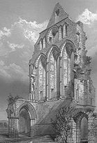
In the early 1600s the fortified dwelling is referred to as Easter-Hill of Byith a pretty building, veill planted belonging to Johne Cuninghame. Blaeu's map of 1654, originating in the 1600s, shows a castellated tower named 'Hill of Beith.'
General Roy's Military Survey of Scotland (1747–55) map shows two groups of buildings at 'Hill of Bieth' (sic), the easterly group being enclosed within a boundary wall and having one substantial 'L' shaped building as well as two smaller outbuildings. Neither the Grange nor Nether Hill of Beith have such a large building marked.
Armstrong's map of 1775 shows a building marked as 'Mains' with a fairly substantial ruined castle close by. It is not marked as a ruin, however the identical image as for the ruined Giffin Castle is used. Nearby estates have a 'mansion house' symbol used. Dobie states that the castle's stones had been mainly removed by the middle of the 18th century. The 1832 map no longer marks the castle site or its formal access.
Remains of substantial wall foundations of squared masonry 1.4m thick and 0.4m high, mainly overgown with grass turfs, are visible in the copse around 200m north-west of the Court Hill and above Boghall House. A section 5.0m long and 0.6m thick of the field boundary wall consists of mortared masonry as opposed to drystone dyke. Nearby ruined drystone dykes may be composed of stones robbed from the castle, its boundary wall and outbuildings. Some of these stones are clearly worked or dressed building remnants.
The 1845 Statistical Account states that the square castle stood close to the Court Hill and was removed in the middle of the 18th century. Porterfield in 1925 states that 'Johnnie Cunningham's' home, the tower castle, stood at Easter Hill of Beith in the field at top of the old grassy lane that runs up from Netherhill Toll.
The quote from Love's work is - "Their farm is clearly indicated by the name "Grangehill" (NS 356 546) and "The Maynes". Blaeu's map indicates a castellated mansion or tower house on part of the Maynes, half a mile SW of the Grange, where the abbot may have stayed when in the locality."
The castle may have been converted and the buildings used as a farm dwelling before its final demise as a dwelling in the 18th century.
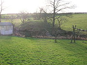 The placename 'Hill of Beith' itself refers not to the hill, but instead to that rare survival of feudal power, the 'Court Hill' or moot hill
, that sits close to Boghall House, beside the burn that runs down from the site of the old Loch Brand to eventually reach its confluence with the Powgree Burn. The hill is composed of soil and boulders and measures 17 paces in diameter at the bottom, and 6 feet 8 inches high. The flat top, which is flat is not totally circular, and is 8 paces in diameter.
As feudal lords, the Abbots of Kilwinning Abbey and their secular successors held and presided over courts of law on this hill, it being the 'Caput of the Barony of Beith', the site where the legal entity of the barony was physically located. The dissolution of the monasteries ended the abbots involvement in the mid 16th century. Such court hills were sometimes built from soil deliberately brought to thje site from all the different parts of the lands of the barony.
The small copse next to the castle site is known as the 'Hangman's Wood' locally, suggesting that this was the site of the barony gallows.
and it is recorded that in 1482 the monks had to take legal action against the Montgomeries of Giffin Castle and a James Ker, who were accused of dangerous destruction and down-casting of the fosses and dikes of the loch called Loch Brand. Although shown on a map of 1654 it no longer appears on Roy's map of circa 1747. Despite this cartographic evidence it is said to have been finally drained in 1780 at which time oak and elm stakes were uncovered which may have been evidence of a crannog
once existing here. The new lands were used for agriculture and are discernable today (2010) as poorly drained wetlands.
This old habitation, marked as Boighall on a 1654 map, sits next to the site of the old loch, and was the home to the mother, Janet Pollock, of Robert Tannahill
the 'Weaver Poet'.
The Hill of Beith Castle site was situated near the old turnpike from Kilwinning via Beith to Coldstream Bridge. It was built under the 1767 Ayr Roads Act.
'Slim Jim' Baxter, a player with Glasgow Rangers, Sunderland, Nottingham Forest and Scotland grew up in Hill O’Beith.
The 'Wood of Beit', now the 'Moor of Beith', has been identified with an Arthurian site where according to Taliessin in a poem under the name of 'Canowan' it was the site of a battle in the wood of Beit at the close of the day.
Cunninghame
Cunninghame is a former comital district of Scotland and also a district of the Strathclyde Region from 1975–1996.-Historic Cunninghame:The historic district of Cunninghame was bordered by the districts of Renfrew and Clydesdale to the north and east respectively, by the district of Kyle to the...
, and the Sherrifdom of Ayr, now the Parish of Beith
Beith
Beith is a small town situated in the Garnock Valley in North Ayrshire, Scotland approximately 20-miles south-west of Glasgow. The town is situated on the crest of a hill and was known originally as the "Hill o' Beith" after its Court Hill.-History:-Name:Beith's name is thought to emanate from...
, North Ayrshire
North Ayrshire
North Ayrshire is one of 32 council areas in Scotland with a population of roughly 136,000 people. It is located in the south-west region of Scotland, and borders the areas of Inverclyde to the north, Renfrewshire to the north-east and East Ayrshire and South Ayrshire to the East and South...
, Scotland
Scotland
Scotland is a country that is part of the United Kingdom. Occupying the northern third of the island of Great Britain, it shares a border with England to the south and is bounded by the North Sea to the east, the Atlantic Ocean to the north and west, and the North Channel and Irish Sea to the...
.
The Abbots of Kilwinning Abbey
The TironensianTironensian
The Tironensian Order or the Order of Tiron was a Roman Catholic monastic order named after the location of the mother abbey in the woods of Tiron in Perche, some 35 miles west of Chartres in France)...
monks of Kilwinning Abbey
Kilwinning Abbey
Kilwinning Abbey is a ruined abbey located in the centre of the town of Kilwinning, North Ayrshire.-The establishment of the Abbey:The ancient name of the town is 'Segdoune' or 'Saigtown', probably derived from 'Sanctoun', meaning the 'town of the saint'. Saint Winnings festival was on 21 January...
held a Grange
Grange
-Buildings:* Grange House , Bo'ness, Scotland, built in 1564, and demolished in 1906* Hamilton Grange National Memorial, a historic house in New York City...
or farmland at Beith
Beith
Beith is a small town situated in the Garnock Valley in North Ayrshire, Scotland approximately 20-miles south-west of Glasgow. The town is situated on the crest of a hill and was known originally as the "Hill o' Beith" after its Court Hill.-History:-Name:Beith's name is thought to emanate from...
, given to the abbey by Sir William de Cunninghame in the early 14th century. This ownership involved the monks in extensive agricultural activities and details of the rents from their farms show a considerable annual production of cheese in particular, 268 recorded for one year alone.
Beith
Beith is a small town situated in the Garnock Valley in North Ayrshire, Scotland approximately 20-miles south-west of Glasgow. The town is situated on the crest of a hill and was known originally as the "Hill o' Beith" after its Court Hill.-History:-Name:Beith's name is thought to emanate from...
had been given to the Kilwinning monks by Richard de Morville's wife towards the end of the 12th century and the monks
as ecclesiastical barons, with the feudal right of 'pit and gallows', had a court hill
Moot hill
A moot hill or mons placiti is a hill or mound historically used as an assembly or meeting place. In early medieval Britain, such hills were used for "moots", meetings of local people to settle local business. Among other things, proclamations might be read; decisions might be taken; court cases...
where they delivered local justice. This artificial earth mound is still in existence, standing close to Boghall House. The abbey's farm or Grange was most likely at Grangehill, a small estate nearby.
The abbot may have stayed at the Hill of Beith castle when in the locality as tower may have been the main building of the monks' grange, being secularised upon the dissolution of the monastery and passing into the hands of the aristocracy. The site is prominent and well defended by the natural slopes, overlooking the old Loch Brand site.
The lairds of the Barony of Beith
The Abbot of Kilwinning feued out the 'Lands of Hill of Beith' to a cadet branch of the Cuninghames of KilmaursKilmaurs Place
Kilmaurs Place, The Place or Kilmaurs House, is an old mansion house or fortalice at in Kilmaurs, East Ayrshire, Scotland. The house stands on a prominence above the Carmel Water and has a commanding view of the surrounding area.-Introduction:...
, Earls of Glencairn
Earl of Glencairn
The title of Earl of Glencairn was created in the Peerage of Scotland in 1488 for the first Lord Kilmaurs .On the death of the fifteenth earl in 1796, there existing no original Letters Patent of the creation nor a given remainder in the various confirmations in title of previous earls the title...
in the person of John Cuninghame, son of Sir William Cuninghame of Caddel, near Giffordland
Giffordland, Ayrshire
Giffordland is in North Ayrshire, Parish of Dalry in the former Region of Strathclyde.- Introduction :Giffordland was only a small barony, however the families associated with it played an active part in the history of feudal Scotland....
outside Dalry
Dalry
Dalry is the name of several places in Scotland:* Dalry, North Ayrshire* Dalry, Edinburgh* St. John's Town of Dalry You may also be looking for Dalrigh or the Battle of Dalrigh...
.
At the Reformation, James Hamilton, son of Gavin Hamilton
Gavin Hamilton
Gavin Hamilton was an early modern Scottish prelate, coadjutor of the Archdiocese of St. Andrews, and Archbishop of St. Andrews.Gavin was the son of James Hamilton of Raploch. He had been Abbot of Kilwinning. In 1555, he was appointed as the coadjutor, i.e. successor, of Archbishop John Hamilton of...
the last Abbot of Kilwinning, obtained the twenty-four shilling land of old extent with the teinds of the same of Overhill (Easter) Hill of Beith and then in around 1579 he sold them to Lord Robert Boyd. The Cunninghames however once again held the castle and lands in the early 1600s at the time of Timothy Pont
Timothy Pont
Timothy Pont was a Scottish topographer, the first to produce a detailed map of Scotland. Pont's maps are among the earliest surviving to show a European country in minute detail, from an actual survey.-Life:...
's famous survey of Cunninghame.
Records show that the title 'Beith', 'Hill of Beith' or 'Gudeman of Beith' was applied to John Cuninghame, who was also the ruling elder for the parish of Beith in 1647 and 1649. John was the defender in the process of setting the stipend of the Rev. James Fullarton. Minister of Beith. In 1662 John Cuninghame was heavily fined, the amount being £626 13s 4d, for his support of the religious zealots Colonel Strachan and Colonel Ker who as members of the Covenanter Army had in 1650 caused considerable damage to the lands of the Earl of Queensberry.
The fact that John Cuninghame was recorded as the 'Gudeman of Beith' suggests that he held his lands from the 'true' laird, possibly Lord Boyd as previously mentioned. A feudal laird held land from the King, however a proprietor who held lands from the laird by purchase or otherwise was referred to as the Gudeman of that Ilk; also a man of equal rank or the head of a household.
The Cuninghames had sold the castle and lands of Hill of Beith by the end of the 17th century and in around 1798 Hugh Brown of Broadstone
Broadstone, North Ayrshire
Broadstone lies close to the small village of Gateside in North Ayrshire, Scotland about half a mile east of Beith in the old Barony of Giffen.-The castle:The ruins of Braidstone or Broadstone Castle remained until about 1850...
purchased Easter Hill of Beith and his son, also Hugh, purchased the farm and lands of Nether Hill of Beith circa 1808.
Easter and Nether Hill of Beith
| Etymology |
| The name Hill of Beith derives from the old barony Court Hill. All baronies had a Court, Moot or Justice hill upon which the Barony Court met to settle local legal cases as presided over by the laird or his nominated baillie. |
These two dwellings and their associated lands made up the Barony of Hill of Beith and are recorded in the 1600s as being held by the monastery of Kilwinning. The monks also held Loch Brand
Loch Brand
Loch Brand or Loch of Boghall was situated in a depression between the Grange Estate, Crummock, Hill of Beith Castle site and Boghall in the Parish of Beith, East Ayrshire, Scotland. The loch was fed by the Grange Burn and surface runoff, such as from the old rig and furrows indicated by Roy's Maps...
or Boghall Loch. The shortened version, 'Hill o'Beith' was often used.
'Nether' suggests a building lying below another property, in this case one lying to the west, and marked on Armstrong's 1775 map as 'Mains', the name that was used for a farm attached to a proprietor's dwelling. The Mains farm is shown with a ruined building standing close by. Easter Hill of Beith is also recorded as Overhill of Beith and even West Hill of Beith. Nether was the farm and Easter Hill of Beith was the fortified dwelling of the laird and his family as indicated by the relative size of the buildings and presence of a walled enclosure.
In 1832 only a single farm named 'Hill of Beith' is marked, with the original curving entrance lane that survives as a hedge boundary following the later creation of a new direct entrance from Wardrop Street.
The names Easter and Nether Hill of Beith have ceased to be used; the term Netherhill is now used by the modern buildings at the site of the old toll house.
Hill of Beith Castle
Easter Hill of Beith was probably a castellated mansion, fortalice or tower house close to Nether or Hill of Beith Mains, half a mile south-west of the Grange, the monks farm where the Abbot of Kilwinning may have stayed when in the locality if not at the castle site itself, overlooking their loch and their court hill.In the early 1600s the fortified dwelling is referred to as Easter-Hill of Byith a pretty building, veill planted belonging to Johne Cuninghame. Blaeu's map of 1654, originating in the 1600s, shows a castellated tower named 'Hill of Beith.'
General Roy's Military Survey of Scotland (1747–55) map shows two groups of buildings at 'Hill of Bieth' (sic), the easterly group being enclosed within a boundary wall and having one substantial 'L' shaped building as well as two smaller outbuildings. Neither the Grange nor Nether Hill of Beith have such a large building marked.
Armstrong's map of 1775 shows a building marked as 'Mains' with a fairly substantial ruined castle close by. It is not marked as a ruin, however the identical image as for the ruined Giffin Castle is used. Nearby estates have a 'mansion house' symbol used. Dobie states that the castle's stones had been mainly removed by the middle of the 18th century. The 1832 map no longer marks the castle site or its formal access.
Remains of substantial wall foundations of squared masonry 1.4m thick and 0.4m high, mainly overgown with grass turfs, are visible in the copse around 200m north-west of the Court Hill and above Boghall House. A section 5.0m long and 0.6m thick of the field boundary wall consists of mortared masonry as opposed to drystone dyke. Nearby ruined drystone dykes may be composed of stones robbed from the castle, its boundary wall and outbuildings. Some of these stones are clearly worked or dressed building remnants.
The 1845 Statistical Account states that the square castle stood close to the Court Hill and was removed in the middle of the 18th century. Porterfield in 1925 states that 'Johnnie Cunningham's' home, the tower castle, stood at Easter Hill of Beith in the field at top of the old grassy lane that runs up from Netherhill Toll.
The quote from Love's work is - "Their farm is clearly indicated by the name "Grangehill" (NS 356 546) and "The Maynes". Blaeu's map indicates a castellated mansion or tower house on part of the Maynes, half a mile SW of the Grange, where the abbot may have stayed when in the locality."
The castle may have been converted and the buildings used as a farm dwelling before its final demise as a dwelling in the 18th century.
The Court Hill
Moot hill
A moot hill or mons placiti is a hill or mound historically used as an assembly or meeting place. In early medieval Britain, such hills were used for "moots", meetings of local people to settle local business. Among other things, proclamations might be read; decisions might be taken; court cases...
, that sits close to Boghall House, beside the burn that runs down from the site of the old Loch Brand to eventually reach its confluence with the Powgree Burn. The hill is composed of soil and boulders and measures 17 paces in diameter at the bottom, and 6 feet 8 inches high. The flat top, which is flat is not totally circular, and is 8 paces in diameter.
As feudal lords, the Abbots of Kilwinning Abbey and their secular successors held and presided over courts of law on this hill, it being the 'Caput of the Barony of Beith', the site where the legal entity of the barony was physically located. The dissolution of the monasteries ended the abbots involvement in the mid 16th century. Such court hills were sometimes built from soil deliberately brought to thje site from all the different parts of the lands of the barony.
The small copse next to the castle site is known as the 'Hangman's Wood' locally, suggesting that this was the site of the barony gallows.
Loch Brand or Boghall Loch
This small loch was once held by the monastery of Kilwinning AbbeyKilwinning Abbey
Kilwinning Abbey is a ruined abbey located in the centre of the town of Kilwinning, North Ayrshire.-The establishment of the Abbey:The ancient name of the town is 'Segdoune' or 'Saigtown', probably derived from 'Sanctoun', meaning the 'town of the saint'. Saint Winnings festival was on 21 January...
and it is recorded that in 1482 the monks had to take legal action against the Montgomeries of Giffin Castle and a James Ker, who were accused of dangerous destruction and down-casting of the fosses and dikes of the loch called Loch Brand. Although shown on a map of 1654 it no longer appears on Roy's map of circa 1747. Despite this cartographic evidence it is said to have been finally drained in 1780 at which time oak and elm stakes were uncovered which may have been evidence of a crannog
Crannog
A crannog is typically a partially or entirely artificial island, usually built in lakes, rivers and estuarine waters of Scotland and Ireland. Crannogs were used as dwellings over five millennia from the European Neolithic Period, to as late as the 17th/early 18th century although in Scotland,...
once existing here. The new lands were used for agriculture and are discernable today (2010) as poorly drained wetlands.
Boghall
Bog Hall was acquired by Hew Montgomerie of Braidstane in 1691, succeeded by his son Mathew who died childless. Mathew Pollock of Boghouse acquired the lands in 1734 and was succeeded by his son Mathew in 1771. In turn Matthews son, also Mathew, succeeded in 1790 and in 1826 by his son, another Mathew. Margaret Shedden purchased Bog Hall in 1833 and, after the death of her husband John Shedden Dobie, the property was sold to Charles Greenshields Reid of Grangehill House, a neighbouring property. In 1858 Boghall was sold to William Ross JP, who probably built the present house. In the 20th century the Knox family of Beith were owners.This old habitation, marked as Boighall on a 1654 map, sits next to the site of the old loch, and was the home to the mother, Janet Pollock, of Robert Tannahill
Robert Tannahill
Robert Tannahill was a Scottish poet. Known as the 'Weaver Poet', his music and poetry is contemporaneous with that of Robert Burns.He was born at Castle Street in Paisley on 3 June 1774, the fourth son in a family of seven...
the 'Weaver Poet'.
The Mill of Beith
The water-mill of the Barony of Hill of Beith stood on the Muir or Roebank Burn at Mill of Beith (NS 366 559) where there is a linn or waterfall, called the 'Warlock Craigie'. The present day Mill of Beith dates from the late 18th to early 19th century, being a small rectangular rubble built building with an offset square kiln. The lower part of the wheel splash wall is faced with ashlar. The wheel was mid breast, about 3 ft (0.91m) wide by 16 ft (4.88m) diameter, and was fed from a dam on the burn which ran through a lade under the road running to the mill.Micro-history
The town of Beith itself was once officially known as 'Hill of Beith' and only later became known by its shortend name.The Hill of Beith Castle site was situated near the old turnpike from Kilwinning via Beith to Coldstream Bridge. It was built under the 1767 Ayr Roads Act.
'Slim Jim' Baxter, a player with Glasgow Rangers, Sunderland, Nottingham Forest and Scotland grew up in Hill O’Beith.
The 'Wood of Beit', now the 'Moor of Beith', has been identified with an Arthurian site where according to Taliessin in a poem under the name of 'Canowan' it was the site of a battle in the wood of Beit at the close of the day.
See also
- Loch BrandLoch BrandLoch Brand or Loch of Boghall was situated in a depression between the Grange Estate, Crummock, Hill of Beith Castle site and Boghall in the Parish of Beith, East Ayrshire, Scotland. The loch was fed by the Grange Burn and surface runoff, such as from the old rig and furrows indicated by Roy's Maps...
- Kilmaurs PlaceKilmaurs PlaceKilmaurs Place, The Place or Kilmaurs House, is an old mansion house or fortalice at in Kilmaurs, East Ayrshire, Scotland. The house stands on a prominence above the Carmel Water and has a commanding view of the surrounding area.-Introduction:...
- Kilwinning AbbeyKilwinning AbbeyKilwinning Abbey is a ruined abbey located in the centre of the town of Kilwinning, North Ayrshire.-The establishment of the Abbey:The ancient name of the town is 'Segdoune' or 'Saigtown', probably derived from 'Sanctoun', meaning the 'town of the saint'. Saint Winnings festival was on 21 January...
- BeithBeithBeith is a small town situated in the Garnock Valley in North Ayrshire, Scotland approximately 20-miles south-west of Glasgow. The town is situated on the crest of a hill and was known originally as the "Hill o' Beith" after its Court Hill.-History:-Name:Beith's name is thought to emanate from...
- Gateside, North AyrshireGateside, North AyrshireGateside is a small village in North Ayrshire, Scotland about half a mile east of Beith on the B777.-The village:Gateside Primary School, headteacher Ms Fiona Dunlop, was opened in 1903, and nowadays it has 74 pupils...
External links
- http://geo.nls.uk/roy/ General Roy's Military map of Scotland.
- http://www.futuremuseum.co.uk Details of the De Soulis, De Morville and other Cunninghame families.
- http://www.s1beith.com/memories/mills-of-beith.html Mills of Beith article on S1 Beith.
- http://www.s1beith.com/memories/hill-of-beith-castle.html Hill of Beith Castle article on S1 Beith.