
Frozen Head State Park
Encyclopedia
Frozen Head State Park and Natural Area is a state park
in Morgan County, Tennessee, in the southeastern United States. The park, situated in the Crab Orchard Mountains
between the city of Wartburg
and the community of Petros
, contains some of the highest mountains in Tennessee
west of the Blue Ridge
.
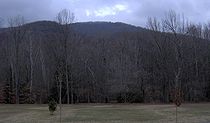
Frozen Head State Park consists of approximately 24000 acres (97 km²), all but 330 acres (1.3 km²) of which is classified as a state natural area. The terrain varies between 1300 ft (396.2 m) to over 3000 ft (914.4 m). with 14 peaks at or over 3000 feet (914.4 m). Frozen Head
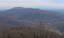
, the park's namesake, is the highest peak at 3324 feet (1,013 m). The mountain's name comes from its snow-capped appearance in colder months. The park's highest elevations allow for unobstructed views of East Tennessee
's three main physiographic features: the Cumberland Plateau
, the Tennessee Valley
, and across the valley, the Great Smoky Mountains
.
 The Crab Orchard Mountains rise along the Cumberland Plateau just west of the plateau's Walden Ridge
escarpment, north of the Sequatchie Valley
, and comprise the southern extreme of the greater Cumberland Mountain
range. The mountains are generally composed of Paleozoic
sandstones and shales of the Pennsylvanian period, formed roughly 300 million years ago. Although the rocks are much younger than the Precambrian
igneous rocks of the Appalachian Mountains to the east, the two mountain systems were both formed during the Appalachian orogeny, when the North American and African plates collided.
Frozen Head State Park is centered along the Flat Fork Valley, a bottomland between Bird Mountain and Old Mac Mountain. The valley's namesake, Flat Fork, rises on the southern slopes of Bird Mountain and follows the entire length of the mountain's southern base before emptying into Crooked Fork near Wartburg. Flat Fork, along with most streams in the park, is drained by the Emory River
, the headwaters of which are located along Bird Mountain's northern slopes.
Frozen Head, the park's highest mountain, rises near the center of the park. The mountain crowns a ridge that rises from State Highway 62 to the south, peaks at Frozen Head, and maintains a relatively high ridgeline before intersecting Fork Mountain in the northern section of the park. Most of the park's major mountains run perpendicular to this central ridge.
 In 1988, the vast majority of Frozen Head State Park's acreage was classified as a state natural area. The non-designated area consists of 330 acres (1.3 km²) at the confluence of Flat Fork and Judge Branch where park offices and the campground are located. This designation, along with the park's previous designation as a state forest, have allowed a mature forest habitat to develop.
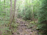
The forest in Frozen Head's lower elevations consists of a mixed mesophytic forest, and includes species of hemlock
, maple
, tulip poplar, oak
, and hickory
. As elevation increases along mountain slopes, the mesophytic forest gives way to an oak forest consisting largely of white oak
and tulip poplar. Chestnut oak
and shortleaf pine
are the dominant species along the higher ridge crests and mountain tops.
 Frozen Head— elevation 3324 feet (1,013.2 m), located near the center of the park. Frozen Head consists of a long ridge that forms an amphitheater-like formation above the Stockstill Valley (occupied by Brushy Mountain State Prison) with the summit at the north end and a subpeak known as Indian Knob (el. 3054 feet (930.9 m)) at the south end.
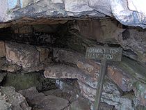
Chimney Top Mountain— elevation 3120 feet (951 m), located in the southwest corner of the park. Chimney Top Mountain is crowned by a series of steep sandstone caprock
s. The highest caprock, at the summit, rises approximately 15–20 feet above the immediate ground. A rock shelter is located at the northern base of the summit caprock.
Bird Mountain— elevation 3142 feet (957.7 m), located in the northwest section of the park. Bird Mountain stretches for roughly 7 miles (11.3 km) between its western base in Wartburg and its junction with Fork Mountain at Emory Gap. The source of the Emory River is located along the northern slopes of Bird Mountain, just below the mountain's summit.
 Old Mac Mountain— elevation 3132 feet (954.6 m), located near the center of the park. The mountain rises from its base near the park offices in the Flat Fork Valley and stretches for nearly 5 miles (8 km) to its intersection with Frozen Head at Tub Springs Gap.
Mart Fields— elevation 3132 feet (954.6 m), located in the southwest section of the park. Mart Fields consists of a relatively thinly-forested knob at the junction of Chimney Top Mountain and Frozen Head.
Significant mountains in the park's vicinity lying outside the park's boundaries include Big Brushy Mountain to the southeast, Big Fodderstack to the east, Fork Mountain and Buffalo Mountain (noted for its windmills) to the northeast, and Lone Mountain
and Little Brushy Mountain to the southwest.
DeBord Falls, a 12 feet (3.7 m) plunge waterfall along Panther Branch, just above the creek's confluence with Flat Fork.
 What is now Frozen Head State Park was once part of the vast Cherokee
hunting grounds that covered much of East Tennessee and southeastern Kentucky. The area was ceded to the United States government in 1805 with the signing of the Third Treaty of Tellico. The first Euro-American settlers arrived shortly thereafter, although they largely avoided the rugged mountains in favor of the more fertile bottomlands along the upper Emory River.
Although businesses occasionally purchased the Frozen Head area for its natural resources throughout the 19th-century, the area remained largely undisturbed until the state of Tennessee purchased it in 1894 for the location of Brushy Mountain State Prison. The state hoped to use convict labor to mine the Cumberlands' ample coal resources, with the heavy forest providing wood for construction of mine shafts. In 1911, the Emory River Lumber Company purchased the Frozen Head area and cut most of the forest's commercial timber. Major logging operations in the forest commenced in 1925.
 In 1933, Tennessee Governor Harry McAlister set aside a large part of Brushy Mountain State Prison's lands for the establishment of Morgan State Forest. The Civilian Conservation Corps
arrived that same year to construct roads and facilities for forest maintenance. CCC operations continued in the forest until 1941, although rattlesnakes and prison escapes prevented the establishment of a camp within the forest until 1938.
A large part of Morgan State Forest burned in a forest fire in 1952, and the forestry division transferred the lands to the parks division 18 years later for the establishment of Frozen Head State Park. In 1988, most of park's acreage was classified as a state natural area, restricting development to a 330 acres (1.3 km²) area around the confluence of Flat Fork and Judge Branch.
 Frozen Head's developed area includes a campground with 20 campsites and a 75-person group campsite, a 240-person amphitheater, and several picnic areas and sports fields. Most major park facilities are located in the 330 acres (1.3 km²) designated for development area in the Flat Fork Valley.
Eleven backcountry campsites are scattered throughout the park, most ranging between 1 and 4 miles (6.4 km) from the parking lot. The major backcountry sites are located at Tub Springs, Mart Fields, Chimney Tops, Panther Gap, and Bird Mountain.
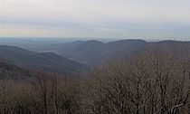
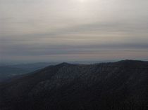 In 2006, the park replaced the aging CCC firetower at the summit of Frozen Head with an observation deck. The observation deck rises just above the treeline and allows for a 360-degree view of the surrounding terrain. The Great Smoky Mountains and the Tennessee Valley span the eastern horizon. Walden Ridge
— where the Tennessee Valley meets the Cumberland Plateau— is visible to the south.
Fork Mountain dominates the view to the north and northeast, although the 360 feet (109.7 m) windmills of the Tennessee Valley Authority
's Buffalo Mountain Wind Park are visible just beyond the mine-scarred mountain. Most of these windmills were built in 2004 as part of TVA's "Green Energy" initiative.
Big Fodderstack is visible immediately to the east, and Big Brushy Mountain lords above the community of Petros to the southeast. Brushy Mountain State Prison is visible through the treeline at the southeastern base of Frozen Head. Like Fork Mountain, Big Fodderstack and Big Brushy both bear substantial marks from strip mining, a coal extraction practice common in the Cumberland Mountains.
Indian Knob— the southern subpeak of Frozen Head Mountain— is visible immediately to the south. The peak is often silhoutted against the noon-day sun. Parts of the Watts Bar Lake
impoundment of the Tennessee River are visible approximately 20 miles (32.2 km) to the south.
Mart Fields and Chimney Top Mountain are visible to the southwest. To the west, the Flat Fork Valley and the descending western flank of Bird Mountain dominate the view. The Wartburg area and the Obed River watershed are visible in the distance.
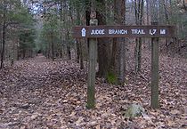
 Approximately 80 miles (128.7 km) of hiking trail connect the remote sections of Frozen Head State Park. Most of the trailheads are located near the park offices, with lesser-used trailheads located at Armes Gap (above Petros) and just off Highway 62 to the south. Most of the trails are open only to hiking, although mountain biking is allowed on the Lookout Tower Trail, which leads to the summit of Frozen Head.
 The Chimney Top Trail connects the park offices with Frozen Head via Chimney Top Mountain. The trail rises along Rough Ridge, descends briefly to the Taylor Branch Valley, and ascends Chimney Top Mountain from the west. From the caprocks, the trail proceeds eastward across the ridge crest to Mart Fields. The caprocks are relatively steep and rise 15–20 feet above the trail, although they can be scaled without technical climbing gear.
Hiking trails ascend the north and south slopes of Old Mac Mountain and Bird Mountain, intersecting the main trail where the mountains intersect the main ridge. The Bird Mountain trailheads are located at the campground. The Old Mac Mountain trailheads are located along the interpretive trail, a short distance from the parking lot.
A section of the Cumberland Trail
traverses the south slope of Bird Mountain (this section of the trail runs congruent with the South Bird Mountain Trail). When the trail is completed, the Cumberland Trail's Frozen Head segment will consist of a 20 miles (32.2 km) stretch connecting the Smoky Mountain segment (Smoky Mountain is north of Fork Mountain, not to be confused with the Great Smoky Mountains) to the northeast with the Obed River segment to the southwest.
is an unusual ultramarathon
event that has been held annually in the park since 1984. Competitors are challenged to run a 100 miles (160.9 km) course over five days, in 20 miles (32.2 km) segments that each must be completed in 12 hours or less. The course is unmarked and traverses very rugged and brushy terrain. As of 2010, only nine competitors had ever finished the race. A tenth competitor finished the race in 2011.
State park
State parks are parks or other protected areas managed at the federated state level within those nations which use "state" as a political subdivision. State parks are typically established by a state to preserve a location on account of its natural beauty, historic interest, or recreational...
in Morgan County, Tennessee, in the southeastern United States. The park, situated in the Crab Orchard Mountains
Crab Orchard Mountains
The Crab Orchard Mountains are a rugged, detached range of the southern Cumberland Mountains. They are situated in East Tennessee atop the Cumberland Plateau just west of the plateau's eastern escarpment, and comprise parts of Morgan, Anderson, and Cumberland counties. The Crab Orchard Mountains...
between the city of Wartburg
Wartburg, Tennessee
Wartburg is a city in Morgan County, Tennessee, United States. The population was 890 at the 2000 census. It is the county seat of Morgan County.-Geography:...
and the community of Petros
Petros, Tennessee
Petros, is an unincorporated town in Morgan County, Tennessee, United States, located on State Route 116.Petros is historically a coal mining town and is also the home of Brushy Mountain State Penitentiary. Some of the town and coal mine scenes for the movie October Sky were filmed...
, contains some of the highest mountains in Tennessee
Tennessee
Tennessee is a U.S. state located in the Southeastern United States. It has a population of 6,346,105, making it the nation's 17th-largest state by population, and covers , making it the 36th-largest by total land area...
west of the Blue Ridge
Blue Ridge Mountains
The Blue Ridge Mountains are a physiographic province of the larger Appalachian Mountains range. This province consists of northern and southern physiographic regions, which divide near the Roanoke River gap. The mountain range is located in the eastern United States, starting at its southern-most...
.
Frozen Head State Park consists of approximately 24000 acres (97 km²), all but 330 acres (1.3 km²) of which is classified as a state natural area. The terrain varies between 1300 ft (396.2 m) to over 3000 ft (914.4 m). with 14 peaks at or over 3000 feet (914.4 m). Frozen Head
Frozen Head
Frozen Head is a mountain in Morgan County, Tennessee. It is the second highest peak in the Crab Orchard Mountains, at . Frozen Head is located in Frozen Head State Park and Natural Area....
, the park's namesake, is the highest peak at 3324 feet (1,013 m). The mountain's name comes from its snow-capped appearance in colder months. The park's highest elevations allow for unobstructed views of East Tennessee
East Tennessee
East Tennessee is a name given to approximately the eastern third of the U.S. state of Tennessee, one of the three Grand Divisions of Tennessee defined in state law. East Tennessee consists of 33 counties, 30 located within the Eastern Time Zone and three counties in the Central Time Zone, namely...
's three main physiographic features: the Cumberland Plateau
Cumberland Plateau
The Cumberland Plateau is the southern part of the Appalachian Plateau. It includes much of eastern Kentucky and western West Virginia, part of Tennessee, and a small portion of northern Alabama and northwest Georgia . The terms "Allegheny Plateau" and the "Cumberland Plateau" both refer to the...
, the Tennessee Valley
Tennessee Valley
The Tennessee Valley is the drainage basin of the Tennessee River and is largely within the U.S. state of Tennessee. It stretches from southwest Kentucky to northwest Georgia and from northeast Mississippi to the mountains of Virginia and North Carolina...
, and across the valley, the Great Smoky Mountains
Great Smoky Mountains
The Great Smoky Mountains are a mountain range rising along the Tennessee–North Carolina border in the southeastern United States. They are a subrange of the Appalachian Mountains, and form part of the Blue Ridge Physiographic Province. The range is sometimes called the Smoky Mountains or the...
.
Geography
Walden Ridge
Walden Ridge is a mountain ridge and escarpment located in Tennessee, in the United States. It marks the eastern edge of the Cumberland Plateau and is generally considered part of it. Walden Ridge is about long, running generally north-south...
escarpment, north of the Sequatchie Valley
Sequatchie Valley
Sequatchie Valley is a relatively long and narrow valley in the U.S. state of Tennessee and, in some definitions, Alabama. It is generally considered to be part of the Cumberland Plateau region of the Appalachian Mountains; it was probably formed by erosion of a compression anticline, rather than...
, and comprise the southern extreme of the greater Cumberland Mountain
Cumberland Mountains
The Cumberland Mountains are a mountain range in the southeastern section of the Appalachian Mountains. They are located in southern West Virginia, western Virginia, eastern edges of Kentucky, and eastern middle Tennessee, including the Crab Orchard Mountains...
range. The mountains are generally composed of Paleozoic
Paleozoic
The Paleozoic era is the earliest of three geologic eras of the Phanerozoic eon, spanning from roughly...
sandstones and shales of the Pennsylvanian period, formed roughly 300 million years ago. Although the rocks are much younger than the Precambrian
Precambrian
The Precambrian is the name which describes the large span of time in Earth's history before the current Phanerozoic Eon, and is a Supereon divided into several eons of the geologic time scale...
igneous rocks of the Appalachian Mountains to the east, the two mountain systems were both formed during the Appalachian orogeny, when the North American and African plates collided.
Frozen Head State Park is centered along the Flat Fork Valley, a bottomland between Bird Mountain and Old Mac Mountain. The valley's namesake, Flat Fork, rises on the southern slopes of Bird Mountain and follows the entire length of the mountain's southern base before emptying into Crooked Fork near Wartburg. Flat Fork, along with most streams in the park, is drained by the Emory River
Emory River
The Emory River is a stream draining a portion of Tennessee's Cumberland Plateau.-Hydrography:The Emory River rises on the slopes of Frozen Head and Bird Mountain, prominent peaks in that part of the Cumberland Plateau in Morgan County, Tennessee. Frozen Head is the focus of a Tennessee state park...
, the headwaters of which are located along Bird Mountain's northern slopes.
Frozen Head, the park's highest mountain, rises near the center of the park. The mountain crowns a ridge that rises from State Highway 62 to the south, peaks at Frozen Head, and maintains a relatively high ridgeline before intersecting Fork Mountain in the northern section of the park. Most of the park's major mountains run perpendicular to this central ridge.
Frozen Head State Natural Area
The forest in Frozen Head's lower elevations consists of a mixed mesophytic forest, and includes species of hemlock
Tsuga
Tsuga is a genus of conifers in the family Pinaceae. The common name hemlock is derived from a perceived similarity in the smell of its crushed foliage to that of the unrelated plant poison hemlock....
, maple
Maple
Acer is a genus of trees or shrubs commonly known as maple.Maples are variously classified in a family of their own, the Aceraceae, or together with the Hippocastanaceae included in the family Sapindaceae. Modern classifications, including the Angiosperm Phylogeny Group system, favour inclusion in...
, tulip poplar, oak
Oak
An oak is a tree or shrub in the genus Quercus , of which about 600 species exist. "Oak" may also appear in the names of species in related genera, notably Lithocarpus...
, and hickory
Hickory
Trees in the genus Carya are commonly known as hickory, derived from the Powhatan language of Virginia. The genus includes 17–19 species of deciduous trees with pinnately compound leaves and big nuts...
. As elevation increases along mountain slopes, the mesophytic forest gives way to an oak forest consisting largely of white oak
White oak
Quercus alba, the white oak, is one of the pre-eminent hardwoods of eastern North America. It is a long-lived oak of the Fagaceae family, native to eastern North America and found from southern Quebec west to eastern Minnesota and south to northern Florida and eastern Texas. Specimens have been...
and tulip poplar. Chestnut oak
Chestnut oak
Quercus prinus , the chestnut oak, is a species of oak in the white oak group, Quercus sect. Quercus. It is native to the eastern United States, where it is one of the most important ridgetop trees from southern Maine southwest to central Mississippi, with an outlying northwestern population in...
and shortleaf pine
Shortleaf Pine
Pinus echinata is a species of pine native to the eastern United States from southern New York south to northern Florida, west to the extreme southeast of Kansas, and southwest to eastern Texas. The tree is variable in form, sometimes straight, sometimes crooked, with an irregular crown...
are the dominant species along the higher ridge crests and mountain tops.
Mountains
Chimney Top Mountain— elevation 3120 feet (951 m), located in the southwest corner of the park. Chimney Top Mountain is crowned by a series of steep sandstone caprock
Caprock
The Caprock is a region in the Panhandle of Texas . It is the land to the west of the Caprock Escarpment, which separates it from plains stretching to the east at a much lower elevation....
s. The highest caprock, at the summit, rises approximately 15–20 feet above the immediate ground. A rock shelter is located at the northern base of the summit caprock.
Bird Mountain— elevation 3142 feet (957.7 m), located in the northwest section of the park. Bird Mountain stretches for roughly 7 miles (11.3 km) between its western base in Wartburg and its junction with Fork Mountain at Emory Gap. The source of the Emory River is located along the northern slopes of Bird Mountain, just below the mountain's summit.
Mart Fields— elevation 3132 feet (954.6 m), located in the southwest section of the park. Mart Fields consists of a relatively thinly-forested knob at the junction of Chimney Top Mountain and Frozen Head.
Significant mountains in the park's vicinity lying outside the park's boundaries include Big Brushy Mountain to the southeast, Big Fodderstack to the east, Fork Mountain and Buffalo Mountain (noted for its windmills) to the northeast, and Lone Mountain
Lone Mountain State Forest
Lone Mountain State Forest is a state forest in Morgan County, Tennessee, located in the southeastern United States. The forest consists of managed by the Tennessee Department of Agriculture....
and Little Brushy Mountain to the southwest.
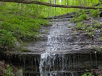
Waterfalls
Emory Gap Falls, a 25 feet (7.6 m) plunge waterfall amidst the headwaters of Flat Fork on the southeast slope of Bird Mountain.DeBord Falls, a 12 feet (3.7 m) plunge waterfall along Panther Branch, just above the creek's confluence with Flat Fork.
Other features
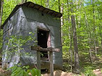
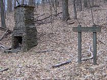
Rock outcroppings— some of which form natural rock shelters— are common throughout the park, especially in higher elevations. The most substantial rock shelter is located near the summit of Frozen Head, and is accessible via short spur trail from the main tower trail. Abandoned prison mines between Frozen Head and Armes Gap and a CCC dynamite shack along the South Old Mac Mountain Trail are among the park's historical features.History
Cherokee
The Cherokee are a Native American people historically settled in the Southeastern United States . Linguistically, they are part of the Iroquoian language family...
hunting grounds that covered much of East Tennessee and southeastern Kentucky. The area was ceded to the United States government in 1805 with the signing of the Third Treaty of Tellico. The first Euro-American settlers arrived shortly thereafter, although they largely avoided the rugged mountains in favor of the more fertile bottomlands along the upper Emory River.
Although businesses occasionally purchased the Frozen Head area for its natural resources throughout the 19th-century, the area remained largely undisturbed until the state of Tennessee purchased it in 1894 for the location of Brushy Mountain State Prison. The state hoped to use convict labor to mine the Cumberlands' ample coal resources, with the heavy forest providing wood for construction of mine shafts. In 1911, the Emory River Lumber Company purchased the Frozen Head area and cut most of the forest's commercial timber. Major logging operations in the forest commenced in 1925.
Civilian Conservation Corps
The Civilian Conservation Corps was a public work relief program that operated from 1933 to 1942 in the United States for unemployed, unmarried men from relief families, ages 18–25. A part of the New Deal of President Franklin D...
arrived that same year to construct roads and facilities for forest maintenance. CCC operations continued in the forest until 1941, although rattlesnakes and prison escapes prevented the establishment of a camp within the forest until 1938.
A large part of Morgan State Forest burned in a forest fire in 1952, and the forestry division transferred the lands to the parks division 18 years later for the establishment of Frozen Head State Park. In 1988, most of park's acreage was classified as a state natural area, restricting development to a 330 acres (1.3 km²) area around the confluence of Flat Fork and Judge Branch.
Park facilities
Eleven backcountry campsites are scattered throughout the park, most ranging between 1 and 4 miles (6.4 km) from the parking lot. The major backcountry sites are located at Tub Springs, Mart Fields, Chimney Tops, Panther Gap, and Bird Mountain.
The Frozen Head observation platform
Walden Ridge
Walden Ridge is a mountain ridge and escarpment located in Tennessee, in the United States. It marks the eastern edge of the Cumberland Plateau and is generally considered part of it. Walden Ridge is about long, running generally north-south...
— where the Tennessee Valley meets the Cumberland Plateau— is visible to the south.
Fork Mountain dominates the view to the north and northeast, although the 360 feet (109.7 m) windmills of the Tennessee Valley Authority
Tennessee Valley Authority
The Tennessee Valley Authority is a federally owned corporation in the United States created by congressional charter in May 1933 to provide navigation, flood control, electricity generation, fertilizer manufacturing, and economic development in the Tennessee Valley, a region particularly affected...
's Buffalo Mountain Wind Park are visible just beyond the mine-scarred mountain. Most of these windmills were built in 2004 as part of TVA's "Green Energy" initiative.
Big Fodderstack is visible immediately to the east, and Big Brushy Mountain lords above the community of Petros to the southeast. Brushy Mountain State Prison is visible through the treeline at the southeastern base of Frozen Head. Like Fork Mountain, Big Fodderstack and Big Brushy both bear substantial marks from strip mining, a coal extraction practice common in the Cumberland Mountains.
Indian Knob— the southern subpeak of Frozen Head Mountain— is visible immediately to the south. The peak is often silhoutted against the noon-day sun. Parts of the Watts Bar Lake
Watts Bar Lake
Watts Bar Lake is a reservoir on the Tennessee River created by Watts Bar Dam as part of the Tennessee Valley Authority system.-Geography:Located about midway between Chattanooga and Knoxville, the lake begins as the Tennessee River below Fort Loudon Dam in Lenoir City, Tennessee and stretches...
impoundment of the Tennessee River are visible approximately 20 miles (32.2 km) to the south.
Mart Fields and Chimney Top Mountain are visible to the southwest. To the west, the Flat Fork Valley and the descending western flank of Bird Mountain dominate the view. The Wartburg area and the Obed River watershed are visible in the distance.
Hiking trails
Hiking trails ascend the north and south slopes of Old Mac Mountain and Bird Mountain, intersecting the main trail where the mountains intersect the main ridge. The Bird Mountain trailheads are located at the campground. The Old Mac Mountain trailheads are located along the interpretive trail, a short distance from the parking lot.
A section of the Cumberland Trail
Cumberland Trail
The Cumberland Trail is a hiking trail following a line of ridges and gorges along the eastern escarpment of the Cumberland Plateau in Tennessee. The trail begins at Cumberland Gap National Historical Park and ends at Chickamauga and Chattanooga National Military Park and Prentice Cooper Wildlife...
traverses the south slope of Bird Mountain (this section of the trail runs congruent with the South Bird Mountain Trail). When the trail is completed, the Cumberland Trail's Frozen Head segment will consist of a 20 miles (32.2 km) stretch connecting the Smoky Mountain segment (Smoky Mountain is north of Fork Mountain, not to be confused with the Great Smoky Mountains) to the northeast with the Obed River segment to the southwest.
Barkley Marathons
The Barkley MarathonsBarkley Marathons
The Barkley Marathons is a 100 Mile Run and a 60 Mile Fun Run held annually in Frozen Head State Park near Wartburg, Tennessee in late March or early April....
is an unusual ultramarathon
Ultramarathon
An ultramarathon is any sporting event involving running longer than the traditional marathon length of .There are two types of ultramarathon events: those that cover a specified distance, and events that take place during specified time...
event that has been held annually in the park since 1984. Competitors are challenged to run a 100 miles (160.9 km) course over five days, in 20 miles (32.2 km) segments that each must be completed in 12 hours or less. The course is unmarked and traverses very rugged and brushy terrain. As of 2010, only nine competitors had ever finished the race. A tenth competitor finished the race in 2011.
External links
- Frozen Head State Park — official website
- Frozen Head landforms
- Frozen Head tower