

Fox Point Hurricane Barrier
Encyclopedia
Providence River
thumb|The city of Providence as seen from the Providence River at its confluence with the Narragansett BayThe Providence River is a tidal river in the U.S. state of Rhode Island. It flows approximately 8 miles...
in Providence, Rhode Island
Providence, Rhode Island
Providence is the capital and most populous city of Rhode Island and was one of the first cities established in the United States. Located in Providence County, it is the third largest city in the New England region...
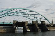
, located 750 feet (228.6 m) upstream from Fox Point. It was constructed between 1960 and 1966 to protect the low-lying downtown area of the city from damaging storm surge
Storm surge
A storm surge is an offshore rise of water associated with a low pressure weather system, typically tropical cyclones and strong extratropical cyclones. Storm surges are caused primarily by high winds pushing on the ocean's surface. The wind causes the water to pile up higher than the ordinary sea...
and floods associated with hurricanes and other major storm events.
The Fox Point Hurricane Barrier consists of five main parts: river gates, rock and earthen dikes along each shore, vehicular gates along each shore where roads pass through the dikes, canal gates at the west end of the barrier associated with the nearby electric power station, and a pumping station to control the flow of water.
Historical background
Since colonial times, the port of Providence, located at the head of Narragansett BayNarragansett Bay
Narragansett Bay is a bay and estuary on the north side of Rhode Island Sound. Covering 147 mi2 , the Bay forms New England's largest estuary, which functions as an expansive natural harbor, and includes a small archipelago...
, has been a vital part of the city's economy. Ocean-going ships regularly dock along the city's waterfront just south of downtown. During the 19th century, the city became a national leader in industrial output and trade. The downtown area is located in a shallow natural basin with an elevation of only 8–12 ft (2.4–3.7 m) above mean sea level.
In September 1938, the Great New England Hurricane slammed the coast of Southern New England
New England
New England is a region in the northeastern corner of the United States consisting of the six states of Maine, New Hampshire, Vermont, Massachusetts, Rhode Island, and Connecticut...
, killing 250 people in the region and causing millions of dollars in damage. Downtown Providence, a bustling center of commerce was entirely submerged under water, causing about $120 million in damage in the city alone.
Again in 1954, the area was hit by Hurricane Carol
Hurricane Carol
Hurricane Carol was among the worst tropical cyclones to affect the New England region of the United States. It developed from a tropical wave near the Bahamas on August 25, 1954, and gradually strengthened as it moved northwestward. On August 27, Carol intensified to reach winds of , but weakened...
, causing a storm surge as high as 8 feet (2.4 m) in some areas, and resulting in over $41 million in damage.
Local, state and federal officials decided to take action to prevent future devastation. Construction of the barrier was authorized in 1958 under the Flood Control Act.
The $16 million dollar wall has never seen a Category 5 hurricane, but has successfully protected the city in every instance since its construction.
Features
Constructed between 1960 and 1966 at a cost of $14 million, the barrier was the first of its type to be approved for construction in the United StatesUnited States
The United States of America is a federal constitutional republic comprising fifty states and a federal district...
.
River gates
The main feature of the hurricane barrier is a group of three large movable gates which span the river, allowing boats to pass through during normal periods. Each of the three tainter gateTainter gate
The Tainter gate is a type of radial arm floodgate used in dams and canal locks to control water flow. It is named for Wisconsin structural engineer Jeremiah Burnham Tainter....
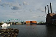
s is 40 feet (12.2 m) wide and weighs 53 tons with a curved outer portion facing the tide. It takes about 30 minutes to lower each gate. The relatively narrow gates prohibit large ships from passing into the inner downtown harbor as they did in the 19th century. However, modern ocean-going vessels now dock at the Port of Providence, located south of the barrier. The inner harbor is now generally occupied by only small pleasure craft during the summer months.
Dikes
The majority of the hurricane barrier's length consists of a 25 feet (7.6 m) high rock and earthen dike along the low-lying areas of the waterfront within the Fox PointFox Point, Providence, Rhode Island
Fox Point is a neighborhood in the East Side of Providence, RI. It is bounded by the Providence and Seekonk rivers, Interstate 195 and the College Hill and Wayland neighborhoods...
and Jewelry District
Jewelry District, Providence, Rhode Island
The Jewelry District is a neighborhood of Providence, Rhode Island located just south of Downtown between Interstate 195 and Henderson Street. Interstate 95 lies at the western edge of the neighborhood, which includes Davol Square and the waterfront along the west bank of the Providence River...
neighborhoods of Providence. The original dike located along the eastern shore has been removed and replaced with vertical concrete walls as part of the construction of the new embankment for the Interstate 195 relocation
Iway
The Iway is the $610 million project by the Rhode Island Department of Transportation to relocate the Interstate 195 and Interstate 95 intersection in Providence, Rhode Island...
.
Vehicular gates
Three sets of huge steel vehicular gates are located under the newly constructed portion of Interstate 195Interstate 195 (Rhode Island-Massachusetts)
Interstate 195 is an Interstate Highway running a combined 40.1 miles in the U.S. states of Massachusetts and Rhode Island. It travels from a junction with Interstate 95 in Providence, Rhode Island east to a junction with Interstate 495 and Route 25 in Wareham, Massachusetts...
, east of the Providence River Bridge, at South Water, South Main and at Benefit Street. On the west shore, vehicular gates are located at Allens Avenue as well as on the property of the Manchester Street Power Plant. The gates are normally in the "open" position to allow traffic to pass through, but are closed to provide a continuous barrier during emergency events.
Canal gates
On the west side of the river, there are also two large canal gates, which control water used to cool the nearby Manchester Street Power Station, which is operated by Dominion ResourcesDominion Resources
Dominion Resources Inc. , commonly referred to as Dominion, is a power and energy company headquartered in Richmond, Virginia that supplies electricity in parts of Virginia and North Carolina and supplies natural gas to parts of West Virginia, Ohio, Pennsylvania, and eastern North Carolina...
.
Pumping station
The barrier also includes a pumping station, housed within a concrete and brick structure located near the western shore of the river. The pumping station contains five 4500 H.P. pumps with instantaneous starting power, and are designed to convey water from the Providence RiverProvidence River
thumb|The city of Providence as seen from the Providence River at its confluence with the Narragansett BayThe Providence River is a tidal river in the U.S. state of Rhode Island. It flows approximately 8 miles...
over the barrier when the gates are closed. (Otherwise, the continuously flowing river water would have no place to go).
Each pump is about 54.7 feet (16.7 m) high and 20 feet (6.1 m) in diameter, and can pump 3.1 million gallons per minute.
Gauges inside the pumping station measure the water level inside and outside the barrier, and control the pumps, in order to maintain the water levels on either side as closely as possible.
Recent history
In 1985, the Fox Point Hurricane Barrier was utilized, sparing downtown ProvidenceDowntown, Providence, Rhode Island
Downtown, also known as Downcity, is the central economic, political, and cultural district of the city of Providence, Rhode Island. It is bounded on the east by Canal Street and the Providence River, to the north by Smith Street, to the west by Interstate 95, and to the south by Henderson Street...
from being inundated in two feet of water from storm surge
Storm surge
A storm surge is an offshore rise of water associated with a low pressure weather system, typically tropical cyclones and strong extratropical cyclones. Storm surges are caused primarily by high winds pushing on the ocean's surface. The wind causes the water to pile up higher than the ordinary sea...
brought by Hurricane Gloria
Hurricane Gloria
Hurricane Gloria was a powerful Cape Verde-type hurricane that formed during the 1985 Atlantic hurricane season and prowled the Atlantic Ocean from September 16 to September 28. Gloria reached Category 4 status on the Saffir-Simpson Hurricane Scale near the Bahamas, but weakened significantly...
, keeping the city dry. In 1991, the Barrier spared the city from Hurricane Bob
Hurricane Bob
Hurricane Bob was one of the costliest hurricanes in New England history. The second named storm and first hurricane of the 1991 Atlantic hurricane season, Bob developed from an area of low pressure near The Bahamas on August 16. The depression steadily intensified, and became Tropical Storm Bob...
, which would have covered downtown in four feet of water. The savings has been estimated at several hundred million dollars and the project operates at a cost-benefit ratio of 2.21 to 1. The barrier was closed on August 28, 2011 in preparation for Hurricane Irene
Hurricane Irene (2011)
Hurricane Irene was a large and powerful Atlantic hurricane that left extensive flood and wind damage along its path through the Caribbean, the United States East Coast and as far north as Atlantic Canada in 2011...
.
The barrier is also used to keep the river level higher during low tides, for the benefit of WaterFire
WaterFire
WaterFire is the award-winning sculpture by Barnaby Evans presented on the rivers of downtown Providence, RI.First created by Evans in 1994 to celebrate the tenth anniversary of First Night Providence, WaterFire has grown to become an annual public art phenomenon.WaterFire is simultaneously a free...
events.
A $3 million overhaul of the barrier's five massive pumps was completed in 2006.