

Iway
Encyclopedia
The Iway is the $610 million project by the Rhode Island Department of Transportation
(RIDOT) to relocate the Interstate 195
and Interstate 95
intersection in Providence, Rhode Island
. As of January 2010, the project was demolishing old structures freed up by the relocation.
 Back in the 1980s, RIDOT reviewed many plans to deal with the aging section of I-195 in Providence, which was built in the 1950s. Along with having to complete numerous repairs on one of the busiest stretches of highway in Rhode Island, traffic volumes had increased tremendously over the years. The highway designed for 75,000 vehicles a day now carries more than 160,000 cars daily.
The old design had other problems. Tight curves, left-hand exits and closely spaced exits have contributed to excessive congestion on the highway, which spills over onto adjacent highways, causing delays for motorists on I-95, the Route 6
/10 connector, and on city streets.
As RIDOT worked on the Iway’s Environmental Impact Statement (EIS) in the early 1990s, the highway’s problems were put to paper. The EIS noted deteriorated bridges, substandard roadway alignments, sharp curves and substandard shoulder widths. During the initial stages of the project, DOT worked on a joint project between the School of Architecture at ETH Zürich, and the Faculty at the Rhode Island School of Design (RISD), Providence, Rhode Island to include studies of the Iway in their "Project Providence," an exploration of the city through computer visualization.
RIDOT looked at three alternatives before choosing the one that was built. An alignment just to the north of the current highway was not selected as it would have corrected only the congestion and tight curves on I-195 itself. It would not deal with the weaving motorists face due to closely spaced exits at the highway interchange, it would not have addressed better access to the Eddy Street hospitals campus, and it would have created only limited opportunities for redevelopment as outlined in the Old Harbor Plan. The plan outlines how the land occupied by the existing highway will be reused.
Another idea that was considered was a no-build alternative, one in which the existing alignment would be reconstructed. This would have addressed problems with deteriorated structures, but done nothing about the congestion, weaving conflicts and existing safety hazards. Additionally, traffic would have been severely impacted during construction.
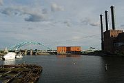
Consideration of these choices led RIDOT to choose the alignment south of the Fox Point Hurricane Barrier
. Safety problems and congestion issues could be addressed, and the removal of the old highway would allow for significant redevelopment of the Providence waterfront and fuller implementation of the Old Harbor Plan. Also, the redevelopment would complement other projects including the construction of Memorial Boulevard, Waterplace Park and the Riverwalk system, and the Capital Center projects.
The opening of the Iway ramp has eased congestion on I-95 North during the afternoon commute. Originally traffic backed up each evening for approximately 2.2 miles (3.5 km). Long traffic backups on this part of I-95 North are unusual except in times of adverse weather or accidents.
, rolling it onto two large barges, and floating it up the Bay. The day of the float, thousands of people lined the shores of the Bay to witness history and watch the bridge sail by. The bridge float also attracted the attention of the History Channel, which produced a documentary on the Iway for its “Mega Movers” series.
The following is a timeline of the new Providence River Bridge construction and float:
October 2005: Work began on the center span at Pier 2 in the Davisville section of the Quonset Business Park (QBP) in North Kingstown, R.I.
March 2006: Cardi Corporation (lead contractor) completed construction of center span.
August 11, 2006: Kickoff event for dignitaries and media held at Davisville Pier 2.
August 21, 2006: Bridge lifted to a height of 30 feet (9.1 m), followed by placement of SPMTs.
August 25, 2006: Bridge rolled to edge of Pier 2.
August 26, 2006: Bridge loaded onto barges and secured for sea voyage.
August 27, 2006: Bridge leaves QBP for Providence. Barges make nearly twice the expected speed and arrive two hours ahead of schedule.
August 28, 2006: Bridge moved into position at new piers and lowered into place.
The podcasts tell the story of how the Iway came to be. It includes various computer-enhanced images to show the new highway on the existing landscape. There are also animations that represent a virtual drive on the new highway, information on the construction of the new Providence River Bridge, and its transport by barge from Quonset to Providence.
On June 11, 2008, RIDOT was informed http://www.dot.ri.gov/news/pages/dispNews.asp?id=404 that it was the recipient of a "Bell Ringer" award from the Publicity Club of New England. The award was for the Iway logo with its three arches and the tag line “Yours. Mine. Ours.” The award is the highest achievement given by the annual competition, which is the region’s premier public relations and communications event.
Rhode Island Department of Transportation
The Rhode Island Department of Transportation is a Rhode Island state government agency charged with construction, maintenance and inspection of a wide range of transportation infrastructure. These include 1,102 miles of state roads and highways, 772 bridges, and 777 traffic signals...
(RIDOT) to relocate the Interstate 195
Interstate 195 (Rhode Island-Massachusetts)
Interstate 195 is an Interstate Highway running a combined 40.1 miles in the U.S. states of Massachusetts and Rhode Island. It travels from a junction with Interstate 95 in Providence, Rhode Island east to a junction with Interstate 495 and Route 25 in Wareham, Massachusetts...
and Interstate 95
Interstate 95 in Rhode Island
Interstate 95, the main north–south Interstate Highway on the east coast of the United States, runs generally southwest-northeast through the U.S. state of Rhode Island. It runs from the border with Connecticut near Westerly through Warwick and Providence and to the Massachusetts state line...
intersection in Providence, Rhode Island
Providence, Rhode Island
Providence is the capital and most populous city of Rhode Island and was one of the first cities established in the United States. Located in Providence County, it is the third largest city in the New England region...
. As of January 2010, the project was demolishing old structures freed up by the relocation.
Summary of project improvements
- The project will free up space in downtown Providence and the Jewelry DistrictJewelry District, Providence, Rhode IslandThe Jewelry District is a neighborhood of Providence, Rhode Island located just south of Downtown between Interstate 195 and Henderson Street. Interstate 95 lies at the western edge of the neighborhood, which includes Davol Square and the waterfront along the west bank of the Providence River...
. - Renovate India Point ParkIndia Point ParkIndia Point Park is a park in the Fox Point neighborhood of Providence, Rhode Island at the confluence of the Seekonk River and Providence River. The park takes its name from the maritime activity connecting Providence with the East and West Indies....
and construct a 50 feet (15.2 m)-wide pedestrian bridge. - Signature arch bridge over the Providence RiverProvidence Riverthumb|The city of Providence as seen from the Providence River at its confluence with the Narragansett BayThe Providence River is a tidal river in the U.S. state of Rhode Island. It flows approximately 8 miles...
. - Improved highway flow, access, and safety. The existing intersection was not built for today's traffic standards. Moreover, the concrete supports have been deteriorating to the point that steel shoring are needed to reinforce the intersection's many bridges. Also, the existing lane alignment is dangerous and promotes congestion as lane shifts are often required to avoid a left sided exit-only lane.
History
The old design had other problems. Tight curves, left-hand exits and closely spaced exits have contributed to excessive congestion on the highway, which spills over onto adjacent highways, causing delays for motorists on I-95, the Route 6
U.S. Route 6 in Rhode Island
U.S. Route 6 is a major east–west road in the U.S. state of Rhode Island. Nationally, the route continues west to Bishop, California and east to Provincetown, Massachusetts. In western Rhode Island, it forms part of one of several routes between Hartford, Connecticut and Providence, Rhode...
/10 connector, and on city streets.
As RIDOT worked on the Iway’s Environmental Impact Statement (EIS) in the early 1990s, the highway’s problems were put to paper. The EIS noted deteriorated bridges, substandard roadway alignments, sharp curves and substandard shoulder widths. During the initial stages of the project, DOT worked on a joint project between the School of Architecture at ETH Zürich, and the Faculty at the Rhode Island School of Design (RISD), Providence, Rhode Island to include studies of the Iway in their "Project Providence," an exploration of the city through computer visualization.
RIDOT looked at three alternatives before choosing the one that was built. An alignment just to the north of the current highway was not selected as it would have corrected only the congestion and tight curves on I-195 itself. It would not deal with the weaving motorists face due to closely spaced exits at the highway interchange, it would not have addressed better access to the Eddy Street hospitals campus, and it would have created only limited opportunities for redevelopment as outlined in the Old Harbor Plan. The plan outlines how the land occupied by the existing highway will be reused.
Another idea that was considered was a no-build alternative, one in which the existing alignment would be reconstructed. This would have addressed problems with deteriorated structures, but done nothing about the congestion, weaving conflicts and existing safety hazards. Additionally, traffic would have been severely impacted during construction.
Consideration of these choices led RIDOT to choose the alignment south of the Fox Point Hurricane Barrier
Fox Point Hurricane Barrier
The Fox Point Hurricane Barrier is a long tidal flood barrier spanning the Providence River in Providence, Rhode Island, located upstream from Fox Point...
. Safety problems and congestion issues could be addressed, and the removal of the old highway would allow for significant redevelopment of the Providence waterfront and fuller implementation of the Old Harbor Plan. Also, the redevelopment would complement other projects including the construction of Memorial Boulevard, Waterplace Park and the Riverwalk system, and the Capital Center projects.
Roadway openings and closings
- November 4, 2007 - New Iway bridge opens to eastbound traffic from I-95 NB to I-195 EB. Old exit 20 from I-95 NB to I-195 EB remains open for access to I-195 exits 1 and 2. I-195 exit 3 eastbound (Gano St.) becomes accessible from new Iway bridge only.
- November 9, 2007 - New onramp from Wickenden and Point Streets to I-195 EB opens. Old onramp closed.
- May 19, 2008 - Temporary onramp to I-195 EB from Hoppin street opens.
- May 22, 2008 - Eastbound Exit 3 offramp to Gano street closed. New eastbound Exit 2 opens from Iway bridge to India Point/Gano Street/Wickenden Street.
- May 27, 2008 - Friendship Street onramp to I-195 EB closed.
- May 29, 2008 - I-95 NB exit 20 to old I-195 EB closed.
- June 13, 2008 - Pine Street overpass over I-95 closed.
- October 15, 2008 - New India Point Park pedestrian bridge over I-195 opens.
- October 29, 2008 - Temporary ramp opens from Blackstone Street to I-95 SB.
- November 7, 2008 - Onramp from Broad Street to I-95 SB closed.
- December 6, 2008 - New exit 20 from I-95 SB to the new I-195 EB opens. New onramp from Plain Street to I-195 EB opens. Old I-195 eastbound roadway closed, including all on and off ramps from old I-195 eastbound.
- June 18, 2009 - New Iway bridge opens to westbound traffic to I-95 SB. Old I-195 Wb remains open to I-95 NB. All ramps to/from old I-195 WB remain open.
- October 20, 2009 - New Exit 20 from I-95 NB to Point Street opens.
- October 22, 2009 - New ramps from Iway bridge to I-95 NB and Point Street (Exit 1A) open. All I-195 WB traffic is now using new highway and the old I-195, and all remaining on-ramps to it, are closed completely. I-195 WB Exit 2 (South Main St) remains open.
- October 13, 2010 - New Clifford Street bridge over I-95 opens. New entrance ramp to I-95 NB from Point Street opens.
- October 29, 2010 - New exit 19 ramp from I-95 SB to Borden and Eddy Streets opens. Old exit 19 ramp remains open temporarily.
- November 15, 2010- Demolition of the old right of way starts
Traffic response
The first few days of the Iway being opened caused lengthy delays for motorists on I-95 South to I-195 East. This was alleviated by several steps RIDOT took. These included combining two on-ramps into one at their merge point with I-195 East, making minor lane adjustments, and a public education campaign to encourage people to get onto I-95 North and then the Iway as opposed to using exits on the old stretch of I-195 where backups were occurring. These changes shifted traffic to the Iway which had excess capacity. In three days traffic was reduced to original evening congestion levels. By the end of the week, congestion had lessened from original levels.The opening of the Iway ramp has eased congestion on I-95 North during the afternoon commute. Originally traffic backed up each evening for approximately 2.2 miles (3.5 km). Long traffic backups on this part of I-95 North are unusual except in times of adverse weather or accidents.
Iway Bridge Float
A significant milestone was the floating of the new Providence River Bridge from the Quonset Business Park to its final resting place in Providence. In August 2006, RIDOT orchestrated a series of events to install the 400 feet (121.9 m) center span for the bridge. The bridge float captured the attention of Rhode Islanders from all over the state who watched on television and read in newspapers about the entire process of raising the bridge, placing it on Self-Propelled Modular Transporters (SPMTs)Self Propelled Modular Transporter
A Self Propelled Modular Transporter is a platform vehicle with a large array of wheels on the bottom. They are used for transporting massive objects such as bridges, oil refining equipment, huge motors, large bridge sections, and other objects that are too big or heavy for trucks but trucks can...
, rolling it onto two large barges, and floating it up the Bay. The day of the float, thousands of people lined the shores of the Bay to witness history and watch the bridge sail by. The bridge float also attracted the attention of the History Channel, which produced a documentary on the Iway for its “Mega Movers” series.
The following is a timeline of the new Providence River Bridge construction and float:
October 2005: Work began on the center span at Pier 2 in the Davisville section of the Quonset Business Park (QBP) in North Kingstown, R.I.
March 2006: Cardi Corporation (lead contractor) completed construction of center span.
August 11, 2006: Kickoff event for dignitaries and media held at Davisville Pier 2.
August 21, 2006: Bridge lifted to a height of 30 feet (9.1 m), followed by placement of SPMTs.
August 25, 2006: Bridge rolled to edge of Pier 2.
August 26, 2006: Bridge loaded onto barges and secured for sea voyage.
August 27, 2006: Bridge leaves QBP for Providence. Barges make nearly twice the expected speed and arrive two hours ahead of schedule.
August 28, 2006: Bridge moved into position at new piers and lowered into place.
Opening-day ceremonies
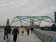
The opening of the Iway was preceded by a public walk on the Iway on October 20, 2007. An estimated 10,000 people attended the event from 9 a.m. to noon. Visitors started lining up one hour before the event start time and RIDOT extended the event by about one hour. Visitors traveled to the site on RIPTA buses from one of two satellite parking locations in Providence, from the Johnson & Wales University Harborside Campus and from the State Offices campus. Once there they received a commemorative program and walked the length of the new Providence River Bridge was well as approach ramps on both the east and west side of the bridge.Iway podcasts
On October 1, 2007, RIDOT began releasing video podcasts of the Iway project. New "episodes" were released weekly. There are a total of 12 episodes, six in English and six in Spanish. The podcasts are available for viewing on a computer or downloading to a personal video player such as an iPod. The podcasts also are available on RIDOT's website, YouTube and iTunes.The podcasts tell the story of how the Iway came to be. It includes various computer-enhanced images to show the new highway on the existing landscape. There are also animations that represent a virtual drive on the new highway, information on the construction of the new Providence River Bridge, and its transport by barge from Quonset to Providence.
Awards
On June 9, 2008, RIDOT announced that the Iway has been nominated for a national award for the Iway bridge float. The competition, America's Transportation Award, is sponsored by the American Association of State Highway Transportation Officials (AASHTO), the U.S. Chamber of Commerce and AAA. The contest recognizes transportation projects completed on time, on budget or those that demonstrate innovative management. The latter category is the one RIDOT is in the running for. On August 13, AASHTO announced that the Iway bridge float is one of 10 finalists for the national award. The Iway bridge received an Innovative Management award in the large project category. There also is a People's Choice Award that can be voted on at the America's Transportation Award website website.On June 11, 2008, RIDOT was informed http://www.dot.ri.gov/news/pages/dispNews.asp?id=404 that it was the recipient of a "Bell Ringer" award from the Publicity Club of New England. The award was for the Iway logo with its three arches and the tag line “Yours. Mine. Ours.” The award is the highest achievement given by the annual competition, which is the region’s premier public relations and communications event.