

Fens and Anglian system
Encyclopedia
East Anglia
East Anglia is a traditional name for a region of eastern England, named after an ancient Anglo-Saxon kingdom, the Kingdom of the East Angles. The Angles took their name from their homeland Angeln, in northern Germany. East Anglia initially consisted of Norfolk and Suffolk, but upon the marriage of...
in England that are navigable and for which the Environment Agency
Environment Agency
The Environment Agency is a British non-departmental public body of the Department for Environment, Food and Rural Affairs and an Assembly Government Sponsored Body of the Welsh Assembly Government that serves England and Wales.-Purpose:...
is the navigation authority
Navigation authority
A navigation authority is a company or statutory body which is concerned with the management of a navigable canal or river.-Rights of a navigation authority:...
.
Many of the rivers drain The Fens
The Fens
The Fens, also known as the , are a naturally marshy region in eastern England. Most of the fens were drained several centuries ago, resulting in a flat, damp, low-lying agricultural region....
between Cambridgeshire
Cambridgeshire
Cambridgeshire is a county in England, bordering Lincolnshire to the north, Norfolk to the northeast, Suffolk to the east, Essex and Hertfordshire to the south, and Bedfordshire and Northamptonshire to the west...
and Lincolnshire
Lincolnshire
Lincolnshire is a county in the east of England. It borders Norfolk to the south east, Cambridgeshire to the south, Rutland to the south west, Leicestershire and Nottinghamshire to the west, South Yorkshire to the north west, and the East Riding of Yorkshire to the north. It also borders...
. These comprise River Glen
River Glen, Lincolnshire
The River Glen is a river in Lincolnshire, England with a short stretch passing through Rutland near Essendine.The river's name appears to derive from a Brythonic Celtic language but there is a strong early English connection.-Naming:...
, Great Ouse
River Great Ouse
The Great Ouse is a river in the east of England. At long, it is the fourth-longest river in the United Kingdom. The river has been important for navigation, and for draining the low-lying region through which it flows. Its course has been modified several times, with the first recorded being in...
, River Nene
River Nene
The River Nene is a river in the east of England that rises from three sources in the county of Northamptonshire. The tidal river forms the border between Cambridgeshire and Norfolk for about . It is the tenth longest river in the United Kingdom, and is navigable for from Northampton to The...
, and River Welland
River Welland
The River Welland is a river in the east of England, some long. It rises in the Hothorpe Hills, at Sibbertoft in Northamptonshire, then flows generally northeast to Market Harborough, Stamford and Spalding, to reach The Wash near Fosdyke. For much of its length it forms the county boundary between...
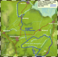
. The Environment Agency is organising the Fens Waterways Link
Fens Waterways Link
The Fens Waterways Link is a project to improve recreational boating opportunities in the counties of Cambridgeshire and Lincolnshire, England. By a combination of improvements to existing waterways and the construction of new links a circular route between Lincoln, Peterborough, Ely and Boston is...
a major construction project to link these rivers for navigation. The first stage is the South Forty-Foot Drain
South Forty-foot drain
The South Forty-Foot Drain is the main channel for the land-drainage of the Black Sluice Level in the Lincolnshire Fens. It lies in eastern England between Guthram Gowt and the Black Sluice pumping station on The Haven, at Boston...
.
Two East Anglian rivers in the grouping are physically separate from the Fens network. These are the River Ancholme
River Ancholme
The River Ancholme is a river in North Lincolnshire, England, and a tributary of the Humber estuary.It rises south of Bishopbridge and passes through many Lincolnshire villages and the market town of Brigg before flowing north into the Humber at South Ferriby.North of Bishopbridge, where the River...
in North Lincolnshire
Lincolnshire
Lincolnshire is a county in the east of England. It borders Norfolk to the south east, Cambridgeshire to the south, Rutland to the south west, Leicestershire and Nottinghamshire to the west, South Yorkshire to the north west, and the East Riding of Yorkshire to the north. It also borders...
which connects to the Humber
Humber
The Humber is a large tidal estuary on the east coast of Northern England. It is formed at Trent Falls, Faxfleet, by the confluence of the tidal River Ouse and the tidal River Trent. From here to the North Sea, it forms part of the boundary between the East Riding of Yorkshire on the north bank...
estuary, and the River Stour
River Stour, Suffolk
The River Stour is a river in East Anglia, England. It is 76 km long and forms most of the county boundary between Suffolk to the north, and Essex to the south. It rises in eastern Cambridgeshire, passes to the east of Haverhill, through Cavendish, Sudbury and the Dedham Vale, and joins the...
which is in Suffolk
Suffolk
Suffolk is a non-metropolitan county of historic origin in East Anglia, England. It has borders with Norfolk to the north, Cambridgeshire to the west and Essex to the south. The North Sea lies to the east...
.
The Environment Agency supervises craft registration for these rivers.