
River Glen, Lincolnshire
Encyclopedia
The River Glen is a river
in Lincolnshire
, England
with a short stretch passing through Rutland
near Essendine
.
The river's name appears to derive from a Brythonic
Celtic language but there is a strong early English
connection.
s, which has come down to us in the form of languages like Welsh
, the neighbouring rivers, the Glen and the Welland
seem to have been given contrasting names. The Welland flowed from the area underlain by the Northampton Sand
s which in many places are bound together by iron oxide
to form ironstone
. In the Roman period, the sands were easily worked as arable land
and the ironstone was dug for smelting
. In both cases, the ground was exposed to erosion
which meant that silt
was carried down to The Fens
by the river
. In modern Welsh, gwaelod means bottom and its plural, gwaelodion means sediment
. Among the medieval forms of the name 'Welland' is Weolod. Since, in certain grammatical circumstances (soft mutation) the Welsh initial 'G' is lost, the river seems to have been named from its silty nature. In contrast, the Glen flowed from clay
s and limestone
. Areas with clay-based soils tended to remain as woodland
whilst the limestone areas provided grassland
for pasture
. Consequently, the River Glen did not carry much sediment. The modern Welsh for clean is glân. The relative amounts of silt deposited in the fens around Maxey and around Thurlby
respectively, by the two rivers, support this view.
rocks in the west of the county
. The East Glen rises as a number of small streams near to Ropsley
and Humby
, close to the 300 feet (91.4 m) countour. It flows in a southerly direction, passing to the east of Ingoldsby
and to the west of Bulby
, to arrive at Edenham
. The East Glen is sometimes called the River Eden, derived as a back-formation from its passing through the parish of Edenham. It continues south through Toft
, where a Grade II listed bridge built in the early 1800s crosses, and Manthorpe
, where there is another listed bridge with a single elliptical arch built in 1813, before turning east to join the West Glen at Wilsthorpe, Lincolnshire
. The West Glen also has a number of sources, near to the 330 feet (100.6 m) contour at Old Somerby
and Boothby Pagnall. It flows more or less parallel to the East Glen, passing through Bitchfield
, Burton-le-Coggles
, Corby Glen
and Creeton
to reach Essendine
, where it turns east towards Greatford
. In the village, a two-arched stone bridge built in the late 1700s carries Church Lane over the river.
Most of the water from the West Glen river no longer joins that from the East Glen, as it now flows along the Greatford Cut to join the River Welland upstream of Market Deeping
. The re-routing was devised by E. G. Taverner, the chief engineer for the Welland and Deepings Drainage Board, towards the end of the Second World War, and was part of a much larger project which involved the digging of the Coronation Channel, a flood relief channel to divert the Welland around the south-eastern edge of Spalding, and the construction of Fulney lock, to exclude tidal water from the upper Welland. The whole scheme cost £723,000, and the Coronation Channel, which was completed in 1953, was named to commemorate the crowning of Queen Elizabeth II in the same year.
By the time the East and West rivers join, they are only just above the 35 feet (10.7 m) contour. The streams are flowing over the sand and gravel of the bed of a former periglacial
lake
of the Devensian glacial period. Once joined, the river flows in a northerly direction, past Fletland Mill, a former grain mill which was built in 1759, and Kate's Bridge
weir, where a modern bridge carries the A15 road over it. This bypasses a single-arched bridge built in the late 1700s, which has a female head carved on the keystone of the western face, presumed to be the Kate after whom the bridge is named. Beyond the bridges, the river becomes a typical Fens high level carrier, embanked on both sides and partially straightened, with counter drains on both sides of the channel, to collect seepage through the banks, as the normal water levels are higher than the surrounding land. At Tongue End
the waters of the Bourne Eau
join. The river below here is navigable for its last 11.5 miles (18.5 km), and there was once a navigable connection to the Bourne Eau, but the Tongue End pumping station now sits between the two rivers, to aid drainage of the land to the west. The Weir Dyke drain runs along the north bank of the Bourne Eau and then the west bank of the Glen, to join the South Forty-Foot Drain
near Guthram Gowt
. For some distance either side of Tongue End, the Counter Drain runs a considerable distance to the east of the channel, creating washlands between them which can be flooded if water is not able to dischange from the river into the Welland estuary, as a result of the state of the tides. A little before Guthram Gowt, the Counter Drain turns to the east to reach Pode Hole
pumping station, which plays an important part in the drainage of Deeping Fen
.
Beyond Guthram Gowt, the river flows in a north-easterly direction, and is flanked on both sides by drainage ditches because the land is low-lying. It passes through Pinchbeck
and Surfleet
to reach the tidal
entrance sluice
where it joins the River Welland. The sluice is only navigable when the tidal level is the same as the river level.
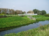
, a ninth-century Welsh monk, records that Arthur, the war leader of the Britons fought his first battle against the Anglo-Saxons
at the mouth of the River Glein [sic]. Thomas Green presents a case for the Glein being the Glen, based on the identification of Linnuis, the district for four subsequent battles, being Lindsey
, although he acknowledges that other locations, including the River Glen, Northumberland
for example, have been suggested. This aerial photo shows the River Glen at Guthram, halfway between Twenty and West Pinchbeck. To the south, the Roman road
across the fen lies hidden, buried in Baston Fen and Pinchbeck Common. In Arthur's time, around the year 500, the north-flowing section of the Glen entered tidal flats lying in Pinchbeck North Fen, to the north-east of Guthram. The line of the river to the east of Guthram appears to have originated as a sea bank but when sediment
ation and fen enclosure caused the sea
no longer to reach it, the river was led away along the bank so that the sea bank became one of river's banks instead. The section of the A151 road
on the 'seaward' side of the Glen was not built until 1822.
Close to the year 500, the spread of Anglian settlement
had recently reached Baston
, at the other end of this Roman road, on the landward side of this fen but burial at the Urns Farm cemetery alongside King Street
then stopped abruptly.
Compared to its neighbour, the Welland, there are few records of the history of the Glen. Dugdale, writing his book The History of Imbanking and Drayning of divers Fenns and Marshes in 1662, which was based on personal observations he made during a trip to the Fens in May 1657, and the records of the Fens Office, most of which were destroyed in the Great Fire of London in 1666, thought it was the least of the rivers he had seen, and recorded that it "serveth almost to none other use, but to carry away so much of its own water, with the rill descending from Burne, as can be kept between two defensible banks." The embanking of the lower river had thus already been done by the time of his account.
Both the Bourne Eau and the Glen were affected by flooding, causing failure of the banks, which was addressed in the Black Sluice act of 1765. The history of navigation is intimately tied up with that of the Bourne Eau, since Bourne was the main centre of population above Spalding. The Bourne Eau act of 1781 appointed trustees, who were to scour and cleanse the river, and could charge tolls to fund the operation. Corn and wool passed down the river, bound for Boston
, while coal and groceries were the principal cargo in the opposite direction. In 1792, Thomas Hawkes wrote about trade in timber, which was carried from Bourne to Spalding, and there was a boat which carried passengers to the market at Spalding on Tuesdays, but he comments that the service was erratic, as there was often too little or too much water for the vessels to operate. The Black Sluice Commissioners installed flood doors between the Glen and the Bourne Eau at Tongue End, to prevent high water levels in the Glen passing up the river to Bourne.
Breaching of the banks by floodwater was a continual problem, with six breaches of the north bank recorded between 1821 and 1882, and eight of the south bank in the same period. Measurement showed that the river level rose by 9 or for every 0.25 inches (6.4 mm) of rain falling on the river's catchment area. The arrival of railways in the area resulted in a rapid decline of river traffic. A railway from Boston to Spalding opened in 1848, while the line from Spalding opened to Bourne in 1866 and on to Sleaford
in 1872. Although occasional boats were still reaching Bourne in 1857, the self-acting doors at Tongue End were replaced by a sluice in the 1860s, which prevented passage from the Glen to the Bourne Eau, although the right of navigation was not officially revoked until 1962, as part of flood defence measures which included the replacement of the sluice by a pumping station in 1966.
Once the route to Bourne was closed off, there was little trade on the river, although a short section of about 1 miles (1.6 km) was used by barges until the 1920s. Although the present head of navigation is at Tongue End, there is evidence that lighters capable of carrying 15 tons used to navigate to Kate's Bridge, where the Lincoln to Peterborough
turnpike road crossed the river, and there are the remains of moorings at Greatford Hall, although navigation to there must have ceased after Kate's Bridge was rebuilt.
In 1734, John Grundy, one of the pioneers in applying scientific principles to the solution of civil engineering problems, was asked by the Adventurers of Deeping Fen
to consider the drainage of 47 square miles (121.7 km²) of fenland to the west of Spalding. His plans included the construction of a reservoir which covered 10 acres (4 ha), impounded by a sluice at Surfleet. At low tide, the water would be released, and the scouring action would deepen the channel, with a consequent improvement in drainage. Humphrey Smith directed the construction, with Grundy acting as engineer, which was completed in 1739, according to a plaque fixed to it at the time. The sluice had three openings, each 8 feet (2.4 m) wide, with pointed doors on the downstream site, which closed as the tide rose, and lifting gates on the upstream side, which would be raised to discharge the water. The sluice was replaced by the present structure in 1824.
are the navigation authority
responsible for the river. They issue licences for its use, and operate Surfleet sluice when required. While the river is navigable for 11.5 miles (18.5 km) to Tongue End, the upper reaches above Pinchbeck Bars are only suitable for smaller boats, as there are no locations where it is possible to turn a boat which is over 30 feet (9.1 m) long. However, the 8.9 miles (14.3 km) section of the river from its source to Guthram Gowt
forms part of the proposed Fens Waterways Link
, which will ultimately link the River Witham
to the River Nene
, via the South Forty-Foot Drain
, the River Glen, the River Welland
and some upgraded drains near Peterborough. Phase One, the connection of the South Forty-Foot Drain to The Haven
at Boston
by a new lock, was completed by December 2008, and was officially opened on 20 March 2009.
Construction of the second phase of the project, which will involve making the South Forty-Foot Drain navigable from Donington
to Guthram Gowt, where a connection with the River Glen will be made, has been delayed by the change in the economic climate, and the complexity of the task.
River
A river is a natural watercourse, usually freshwater, flowing towards an ocean, a lake, a sea, or another river. In a few cases, a river simply flows into the ground or dries up completely before reaching another body of water. Small rivers may also be called by several other names, including...
in Lincolnshire
Lincolnshire
Lincolnshire is a county in the east of England. It borders Norfolk to the south east, Cambridgeshire to the south, Rutland to the south west, Leicestershire and Nottinghamshire to the west, South Yorkshire to the north west, and the East Riding of Yorkshire to the north. It also borders...
, England
England
England is a country that is part of the United Kingdom. It shares land borders with Scotland to the north and Wales to the west; the Irish Sea is to the north west, the Celtic Sea to the south west, with the North Sea to the east and the English Channel to the south separating it from continental...
with a short stretch passing through Rutland
Rutland
Rutland is a landlocked county in central England, bounded on the west and north by Leicestershire, northeast by Lincolnshire and southeast by Peterborough and Northamptonshire....
near Essendine
Essendine
Essendine is a village at the eastern end of the county of Rutland in the East Midlands of England. It lies on the West Glen, close by the earthworks of a small castle.-Geology:...
.
The river's name appears to derive from a Brythonic
Brythonic languages
The Brythonic or Brittonic languages form one of the two branches of the Insular Celtic language family, the other being Goidelic. The name Brythonic was derived by Welsh Celticist John Rhys from the Welsh word Brython, meaning an indigenous Briton as opposed to an Anglo-Saxon or Gael...
Celtic language but there is a strong early English
English people
The English are a nation and ethnic group native to England, who speak English. The English identity is of early mediaeval origin, when they were known in Old English as the Anglecynn. England is now a country of the United Kingdom, and the majority of English people in England are British Citizens...
connection.
Naming
In the language of the Romano-BritonRomano-British
Romano-British culture describes the culture that arose in Britain under the Roman Empire following the Roman conquest of AD 43 and the creation of the province of Britannia. It arose as a fusion of the imported Roman culture with that of the indigenous Britons, a people of Celtic language and...
s, which has come down to us in the form of languages like Welsh
Welsh language
Welsh is a member of the Brythonic branch of the Celtic languages spoken natively in Wales, by some along the Welsh border in England, and in Y Wladfa...
, the neighbouring rivers, the Glen and the Welland
River Welland
The River Welland is a river in the east of England, some long. It rises in the Hothorpe Hills, at Sibbertoft in Northamptonshire, then flows generally northeast to Market Harborough, Stamford and Spalding, to reach The Wash near Fosdyke. For much of its length it forms the county boundary between...
seem to have been given contrasting names. The Welland flowed from the area underlain by the Northampton Sand
Northampton sand
The Northampton Sand, sometimes called the Northamptonshire Sand is a geological formation of Jurassic age found in the East Midlands of England...
s which in many places are bound together by iron oxide
Rust
Rust is a general term for a series of iron oxides. In colloquial usage, the term is applied to red oxides, formed by the reaction of iron and oxygen in the presence of water or air moisture...
to form ironstone
Ironstone
Ironstone is a sedimentary rock, either deposited directly as a ferruginous sediment or created by chemical repacement, that contains a substantial proportion of an iron compound from which iron either can be or once was smelted commercially. This term is customarily restricted to hard coarsely...
. In the Roman period, the sands were easily worked as arable land
Arable land
In geography and agriculture, arable land is land that can be used for growing crops. It includes all land under temporary crops , temporary meadows for mowing or pasture, land under market and kitchen gardens and land temporarily fallow...
and the ironstone was dug for smelting
Smelting
Smelting is a form of extractive metallurgy; its main use is to produce a metal from its ore. This includes iron extraction from iron ore, and copper extraction and other base metals from their ores...
. In both cases, the ground was exposed to erosion
Erosion
Erosion is when materials are removed from the surface and changed into something else. It only works by hydraulic actions and transport of solids in the natural environment, and leads to the deposition of these materials elsewhere...
which meant that silt
Silt
Silt is granular material of a size somewhere between sand and clay whose mineral origin is quartz and feldspar. Silt may occur as a soil or as suspended sediment in a surface water body...
was carried down to The Fens
The Fens
The Fens, also known as the , are a naturally marshy region in eastern England. Most of the fens were drained several centuries ago, resulting in a flat, damp, low-lying agricultural region....
by the river
River
A river is a natural watercourse, usually freshwater, flowing towards an ocean, a lake, a sea, or another river. In a few cases, a river simply flows into the ground or dries up completely before reaching another body of water. Small rivers may also be called by several other names, including...
. In modern Welsh, gwaelod means bottom and its plural, gwaelodion means sediment
Sediment
Sediment is naturally occurring material that is broken down by processes of weathering and erosion, and is subsequently transported by the action of fluids such as wind, water, or ice, and/or by the force of gravity acting on the particle itself....
. Among the medieval forms of the name 'Welland' is Weolod. Since, in certain grammatical circumstances (soft mutation) the Welsh initial 'G' is lost, the river seems to have been named from its silty nature. In contrast, the Glen flowed from clay
Clay
Clay is a general term including many combinations of one or more clay minerals with traces of metal oxides and organic matter. Geologic clay deposits are mostly composed of phyllosilicate minerals containing variable amounts of water trapped in the mineral structure.- Formation :Clay minerals...
s and limestone
Limestone
Limestone is a sedimentary rock composed largely of the minerals calcite and aragonite, which are different crystal forms of calcium carbonate . Many limestones are composed from skeletal fragments of marine organisms such as coral or foraminifera....
. Areas with clay-based soils tended to remain as woodland
Woodland
Ecologically, a woodland is a low-density forest forming open habitats with plenty of sunlight and limited shade. Woodlands may support an understory of shrubs and herbaceous plants including grasses. Woodland may form a transition to shrubland under drier conditions or during early stages of...
whilst the limestone areas provided grassland
Grassland
Grasslands are areas where the vegetation is dominated by grasses and other herbaceous plants . However, sedge and rush families can also be found. Grasslands occur naturally on all continents except Antarctica...
for pasture
Pasture
Pasture is land used for grazing. Pasture lands in the narrow sense are enclosed tracts of farmland, grazed by domesticated livestock, such as horses, cattle, sheep or swine. The vegetation of tended pasture, forage, consists mainly of grasses, with an interspersion of legumes and other forbs...
. Consequently, the River Glen did not carry much sediment. The modern Welsh for clean is glân. The relative amounts of silt deposited in the fens around Maxey and around Thurlby
Thurlby by Bourne
Thurlby is a village and civil parish in the District of South Kesteven in the English county of Lincolnshire, on the edge of The Fens. It is sometimes referred to as Thurlby by Bourne to distinguish it from other villages in Lincolnshire called Thurlby...
respectively, by the two rivers, support this view.
Course
The river has two sources, both in the low ridge of JurassicJurassic
The Jurassic is a geologic period and system that extends from about Mya to Mya, that is, from the end of the Triassic to the beginning of the Cretaceous. The Jurassic constitutes the middle period of the Mesozoic era, also known as the age of reptiles. The start of the period is marked by...
rocks in the west of the county
County
A county is a jurisdiction of local government in certain modern nations. Historically in mainland Europe, the original French term, comté, and its equivalents in other languages denoted a jurisdiction under the sovereignty of a count A county is a jurisdiction of local government in certain...
. The East Glen rises as a number of small streams near to Ropsley
Ropsley
Ropsley is a village about east of Grantham, Lincolnshire, England.-Village:Ropsley has its own village hall which also within the ground has a basketball court, a football pitch and a cricket pitch. There is a golf course located on the outskirts of the village, it has 12 holes after undergoing...
and Humby
Great Humby
Great Humby is the smaller of two hamlets, the other being Little Humby. It is located 7 or 8 miles out of Grantham, Lincolnshire. It is home to roughly 15 people, it has a small chapel with a nearby pond. The main attraction to this small hamlet is the turkey farm.Great Humby is surrounded by...
, close to the 300 feet (91.4 m) countour. It flows in a southerly direction, passing to the east of Ingoldsby
Ingoldsby
Ingoldsby is a small village of approximately 121 households, located seven miles south east of Grantham, in South Kesteven, Lincolnshire.-Parish:...
and to the west of Bulby
Bulby
Bulby is a hamlet in the South Kesteven district of Lincolnshire, England, in the civil parish of Irnham, Bulby and Hawthorpe. The village lies west of the A15, east of the A1, and 4 miles north-west of the town of Bourne...
, to arrive at Edenham
Edenham
Edenham is a village in Lincolnshire, England situated about north-west of Bourne on the A151. The village is part of the civil parish of Edenham Grimsthorpe Elsthorpe & Scottlethorpe.-The Village:...
. The East Glen is sometimes called the River Eden, derived as a back-formation from its passing through the parish of Edenham. It continues south through Toft
Toft, Lincolnshire
Toft is a small village in Lincolnshire, England situated about three miles south-west of Bourne on the A6121. It is part of the Parish of Toft with Lound and Manthorpe....
, where a Grade II listed bridge built in the early 1800s crosses, and Manthorpe
Manthorpe, Bourne
Manthorpe is a small in South Kesteven in Lincolnshire.It is situated about two miles west of Thurlby and three miles south-west along the A6121 from Bourne. A mile to the west is Witham on the Hill....
, where there is another listed bridge with a single elliptical arch built in 1813, before turning east to join the West Glen at Wilsthorpe, Lincolnshire
Wilsthorpe, Lincolnshire
Wilsthorpe is a village in the district of South Kesteven in the county of Lincolnshire, England, about north-east of the town of Stamford and about south of the town of Bourne....
. The West Glen also has a number of sources, near to the 330 feet (100.6 m) contour at Old Somerby
Old Somerby
Old Somerby is situated three miles east of the town of Grantham in southern Lincolnshire in South Kesteven. It is situated on the B1176 approximately 1 mile from its junction with the A52 and B6403 and 250 metres from the East Coast Main Line....
and Boothby Pagnall. It flows more or less parallel to the East Glen, passing through Bitchfield
Bitchfield
Bitchfield is a small village in Lincolnshire, England, consisting of two groups of buildings connected by Dark Lane, known as Bitchfield and Lower Bitchfield, collectively called Bitchfield. It lies on the B1176, running east and parallel to the A1 road, and south east of Grantham.Bitchfield is...
, Burton-le-Coggles
Burton Coggles
Burton Coggles is a small village and civil parish located south of Grantham in the South Kesteven district of Lincolnshire, England...
, Corby Glen
Corby Glen
Corby Glen is a village in southwest Lincolnshire, England.-Geography:The village of Corby Glen is in South Kesteven District in Lincolnshire. It lies mainly to the north of the A151, a former toll road, and to the east of the West Glen River, near where the Glen flows through a small graben in...
and Creeton
Creeton
Creeton is a hamlet in the civil parish of Counthorpe and Creeton in the South Kesteven district of Lincolnshire, England. It lies 5 miles south west from Bourne and 3 miles south from Corby Glen, on the River Glen...
to reach Essendine
Essendine
Essendine is a village at the eastern end of the county of Rutland in the East Midlands of England. It lies on the West Glen, close by the earthworks of a small castle.-Geology:...
, where it turns east towards Greatford
Greatford
Greatford is a village and civil parish in the South Kesteven district of Lincolnshire, England. It lies west of the A15, north-east of Stamford, and south of Bourne...
. In the village, a two-arched stone bridge built in the late 1700s carries Church Lane over the river.
Most of the water from the West Glen river no longer joins that from the East Glen, as it now flows along the Greatford Cut to join the River Welland upstream of Market Deeping
Market Deeping
Market Deeping is a market town in Lincolnshire, England, on the north bank of the River Welland and the A15 road.-Geography:It is the second largest of The Deepings and its eponymous market has been held since at least 1220. The river here forms the Lincolnshire/Cambridgeshire border with...
. The re-routing was devised by E. G. Taverner, the chief engineer for the Welland and Deepings Drainage Board, towards the end of the Second World War, and was part of a much larger project which involved the digging of the Coronation Channel, a flood relief channel to divert the Welland around the south-eastern edge of Spalding, and the construction of Fulney lock, to exclude tidal water from the upper Welland. The whole scheme cost £723,000, and the Coronation Channel, which was completed in 1953, was named to commemorate the crowning of Queen Elizabeth II in the same year.
By the time the East and West rivers join, they are only just above the 35 feet (10.7 m) contour. The streams are flowing over the sand and gravel of the bed of a former periglacial
Periglacial
Periglacial is an adjective originally referring to places in the edges of glacial areas, but it has later been widely used in geomorphology to describe any place where geomorphic processes related to freezing of water occur...
lake
Lake
A lake is a body of relatively still fresh or salt water of considerable size, localized in a basin, that is surrounded by land. Lakes are inland and not part of the ocean and therefore are distinct from lagoons, and are larger and deeper than ponds. Lakes can be contrasted with rivers or streams,...
of the Devensian glacial period. Once joined, the river flows in a northerly direction, past Fletland Mill, a former grain mill which was built in 1759, and Kate's Bridge
Kate's Bridge
Kate's Bridge is a landmark settlement on the A15 road, in the parish of Thurlby, about south of Bourne, Lincolnshire, England. Its size is indicated by the fact that the road signs announcing it at its two ends are on the same pole....
weir, where a modern bridge carries the A15 road over it. This bypasses a single-arched bridge built in the late 1700s, which has a female head carved on the keystone of the western face, presumed to be the Kate after whom the bridge is named. Beyond the bridges, the river becomes a typical Fens high level carrier, embanked on both sides and partially straightened, with counter drains on both sides of the channel, to collect seepage through the banks, as the normal water levels are higher than the surrounding land. At Tongue End
Tongue End
Tongue End is a small Lincolnshire village of Victorian redbrick farmworkers' cottages and early 20th century former council houses at . It is located alongside the Counter Drain Between Baston, Bourne, and Pode Hole, spread out along the road...
the waters of the Bourne Eau
Bourne Eau
Bourne Eau is a short river which rises in the town of Bourne in Lincolnshire, England, and flows in an easterly direction to join the River Glen at Tongue End. It is an embanked river, as its normal level is higher than that of the surrounding Fens...
join. The river below here is navigable for its last 11.5 miles (18.5 km), and there was once a navigable connection to the Bourne Eau, but the Tongue End pumping station now sits between the two rivers, to aid drainage of the land to the west. The Weir Dyke drain runs along the north bank of the Bourne Eau and then the west bank of the Glen, to join the South Forty-Foot Drain
South Forty-foot drain
The South Forty-Foot Drain is the main channel for the land-drainage of the Black Sluice Level in the Lincolnshire Fens. It lies in eastern England between Guthram Gowt and the Black Sluice pumping station on The Haven, at Boston...
near Guthram Gowt
Guthram Gowt
Guthram Gowt is a small settlement between Bourne and Spalding in Lincolnshire, England, at a bend in the River Glen.-The Location:Guthram Gowt is at the southern, upstream end of the South Forty-Foot Drain...
. For some distance either side of Tongue End, the Counter Drain runs a considerable distance to the east of the channel, creating washlands between them which can be flooded if water is not able to dischange from the river into the Welland estuary, as a result of the state of the tides. A little before Guthram Gowt, the Counter Drain turns to the east to reach Pode Hole
Pode Hole
Pode Hole is a small village to the west of Spalding at the confluence of several drainage channels. Two pumping stations discharge water into Vernatt's Drain from land in Deeping Fen to the South and West. Water from Pinchbeck South Fen to the North is also lifted into Vernatt's Drain...
pumping station, which plays an important part in the drainage of Deeping Fen
Deeping Fen
Deeping Fen is a low-lying area in Lincolnshire in the east of England, which covers around . It is bounded by the River Welland and the River Glen, and is extensively drained, but the efficient drainage of the land exercised the minds of several of the great civil engineers of the 17th and 18th...
.
Beyond Guthram Gowt, the river flows in a north-easterly direction, and is flanked on both sides by drainage ditches because the land is low-lying. It passes through Pinchbeck
Pinchbeck
Pinchbeck may refer to:People*Christopher Pinchbeck, English watchmaker who developed the alloy*Daniel Pinchbeck, American author*William Pinchbeck, American pioneerPlacenames*Pinchbeck, Lincolnshire, England*Pinchbeck Engine, A drainage museum nearby...
and Surfleet
Surfleet
Surfleet is a small village on the Lincolnshire fens, situated on the River Glen about five miles north of Spalding.The population is about 1,266 people, many of whom commute to regional populations centres such as Spalding, Boston and Peterborough....
to reach the tidal
Tide
Tides are the rise and fall of sea levels caused by the combined effects of the gravitational forces exerted by the moon and the sun and the rotation of the Earth....
entrance sluice
Sluice
A sluice is a water channel that is controlled at its head by a gate . For example, a millrace is a sluice that channels water toward a water mill...
where it joins the River Welland. The sluice is only navigable when the tidal level is the same as the river level.
History
Historia Brittonum, an ancient history of Britain traditionally attributed to NenniusNennius
Nennius was a Welsh monk of the 9th century.He has traditionally been attributed with the authorship of the Historia Brittonum, based on the prologue affixed to that work, This attribution is widely considered a secondary tradition....
, a ninth-century Welsh monk, records that Arthur, the war leader of the Britons fought his first battle against the Anglo-Saxons
Anglo-Saxons
Anglo-Saxon is a term used by historians to designate the Germanic tribes who invaded and settled the south and east of Great Britain beginning in the early 5th century AD, and the period from their creation of the English nation to the Norman conquest. The Anglo-Saxon Era denotes the period of...
at the mouth of the River Glein [sic]. Thomas Green presents a case for the Glein being the Glen, based on the identification of Linnuis, the district for four subsequent battles, being Lindsey
Lindsey
Lindsey was a unit of local government until 1974 in Lincolnshire, England, covering the northern part of the county. The Isle of Axholme, which is on the west side of the River Trent, has normally formed part of it...
, although he acknowledges that other locations, including the River Glen, Northumberland
River Glen, Northumberland
The River Glen in Northumberland, England is a tributary of the River Till. The College Burn and Bowmont Water, both flowing out of the Cheviot Hills, meet near Kirknewton to form the River Glen...
for example, have been suggested. This aerial photo shows the River Glen at Guthram, halfway between Twenty and West Pinchbeck. To the south, the Roman road
Roman road
The Roman roads were a vital part of the development of the Roman state, from about 500 BC through the expansion during the Roman Republic and the Roman Empire. Roman roads enabled the Romans to move armies and trade goods and to communicate. The Roman road system spanned more than 400,000 km...
across the fen lies hidden, buried in Baston Fen and Pinchbeck Common. In Arthur's time, around the year 500, the north-flowing section of the Glen entered tidal flats lying in Pinchbeck North Fen, to the north-east of Guthram. The line of the river to the east of Guthram appears to have originated as a sea bank but when sediment
Sediment
Sediment is naturally occurring material that is broken down by processes of weathering and erosion, and is subsequently transported by the action of fluids such as wind, water, or ice, and/or by the force of gravity acting on the particle itself....
ation and fen enclosure caused the sea
Sea
A sea generally refers to a large body of salt water, but the term is used in other contexts as well. Most commonly, it means a large expanse of saline water connected with an ocean, and is commonly used as a synonym for ocean...
no longer to reach it, the river was led away along the bank so that the sea bank became one of river's banks instead. The section of the A151 road
A151 road
The A151 road is relatively minor part of the British road system. It lies entirely in the county of Lincolnshire, England. Its western end lies at coordinates otherwise, 1...
on the 'seaward' side of the Glen was not built until 1822.
Close to the year 500, the spread of Anglian settlement
Angles
The Angles is a modern English term for a Germanic people who took their name from the ancestral cultural region of Angeln, a district located in Schleswig-Holstein, Germany...
had recently reached Baston
Baston
Baston is a parish on the edge of The Fens and in the administrative district of South Kesteven, Lincolnshire, England. Like most fen-edge parishes, it was laid out more than a thousand years ago, in an elongated form, to afford the produce from a variety of habitats for the villagers...
, at the other end of this Roman road, on the landward side of this fen but burial at the Urns Farm cemetery alongside King Street
King Street (Roman road)
King Street is the name of a modern road on the line of a Roman road |Durobrivae]]. The whole is I.D. Margary's Roman road number 26. -The Roman road's route:Archaeological work has revealed more of its length than is in use nowadays...
then stopped abruptly.
Compared to its neighbour, the Welland, there are few records of the history of the Glen. Dugdale, writing his book The History of Imbanking and Drayning of divers Fenns and Marshes in 1662, which was based on personal observations he made during a trip to the Fens in May 1657, and the records of the Fens Office, most of which were destroyed in the Great Fire of London in 1666, thought it was the least of the rivers he had seen, and recorded that it "serveth almost to none other use, but to carry away so much of its own water, with the rill descending from Burne, as can be kept between two defensible banks." The embanking of the lower river had thus already been done by the time of his account.
Both the Bourne Eau and the Glen were affected by flooding, causing failure of the banks, which was addressed in the Black Sluice act of 1765. The history of navigation is intimately tied up with that of the Bourne Eau, since Bourne was the main centre of population above Spalding. The Bourne Eau act of 1781 appointed trustees, who were to scour and cleanse the river, and could charge tolls to fund the operation. Corn and wool passed down the river, bound for Boston
Boston, Lincolnshire
Boston is a town and small port in Lincolnshire, on the east coast of England. It is the largest town of the wider Borough of Boston local government district and had a total population of 55,750 at the 2001 census...
, while coal and groceries were the principal cargo in the opposite direction. In 1792, Thomas Hawkes wrote about trade in timber, which was carried from Bourne to Spalding, and there was a boat which carried passengers to the market at Spalding on Tuesdays, but he comments that the service was erratic, as there was often too little or too much water for the vessels to operate. The Black Sluice Commissioners installed flood doors between the Glen and the Bourne Eau at Tongue End, to prevent high water levels in the Glen passing up the river to Bourne.
Breaching of the banks by floodwater was a continual problem, with six breaches of the north bank recorded between 1821 and 1882, and eight of the south bank in the same period. Measurement showed that the river level rose by 9 or for every 0.25 inches (6.4 mm) of rain falling on the river's catchment area. The arrival of railways in the area resulted in a rapid decline of river traffic. A railway from Boston to Spalding opened in 1848, while the line from Spalding opened to Bourne in 1866 and on to Sleaford
Sleaford
Sleaford is a town in the North Kesteven district of Lincolnshire, England. It is located thirteen miles northeast of Grantham, seventeen miles west of Boston, and nineteen miles south of Lincoln, and had a total resident population of around 14,500 in 6,167 households at the time...
in 1872. Although occasional boats were still reaching Bourne in 1857, the self-acting doors at Tongue End were replaced by a sluice in the 1860s, which prevented passage from the Glen to the Bourne Eau, although the right of navigation was not officially revoked until 1962, as part of flood defence measures which included the replacement of the sluice by a pumping station in 1966.
Once the route to Bourne was closed off, there was little trade on the river, although a short section of about 1 miles (1.6 km) was used by barges until the 1920s. Although the present head of navigation is at Tongue End, there is evidence that lighters capable of carrying 15 tons used to navigate to Kate's Bridge, where the Lincoln to Peterborough
Peterborough
Peterborough is a cathedral city and unitary authority area in the East of England, with an estimated population of in June 2007. For ceremonial purposes it is in the county of Cambridgeshire. Situated north of London, the city stands on the River Nene which flows into the North Sea...
turnpike road crossed the river, and there are the remains of moorings at Greatford Hall, although navigation to there must have ceased after Kate's Bridge was rebuilt.
In 1734, John Grundy, one of the pioneers in applying scientific principles to the solution of civil engineering problems, was asked by the Adventurers of Deeping Fen
Deeping Fen
Deeping Fen is a low-lying area in Lincolnshire in the east of England, which covers around . It is bounded by the River Welland and the River Glen, and is extensively drained, but the efficient drainage of the land exercised the minds of several of the great civil engineers of the 17th and 18th...
to consider the drainage of 47 square miles (121.7 km²) of fenland to the west of Spalding. His plans included the construction of a reservoir which covered 10 acres (4 ha), impounded by a sluice at Surfleet. At low tide, the water would be released, and the scouring action would deepen the channel, with a consequent improvement in drainage. Humphrey Smith directed the construction, with Grundy acting as engineer, which was completed in 1739, according to a plaque fixed to it at the time. The sluice had three openings, each 8 feet (2.4 m) wide, with pointed doors on the downstream site, which closed as the tide rose, and lifting gates on the upstream side, which would be raised to discharge the water. The sluice was replaced by the present structure in 1824.
Development
The Environment AgencyEnvironment Agency
The Environment Agency is a British non-departmental public body of the Department for Environment, Food and Rural Affairs and an Assembly Government Sponsored Body of the Welsh Assembly Government that serves England and Wales.-Purpose:...
are the navigation authority
Navigation authority
A navigation authority is a company or statutory body which is concerned with the management of a navigable canal or river.-Rights of a navigation authority:...
responsible for the river. They issue licences for its use, and operate Surfleet sluice when required. While the river is navigable for 11.5 miles (18.5 km) to Tongue End, the upper reaches above Pinchbeck Bars are only suitable for smaller boats, as there are no locations where it is possible to turn a boat which is over 30 feet (9.1 m) long. However, the 8.9 miles (14.3 km) section of the river from its source to Guthram Gowt
Guthram Gowt
Guthram Gowt is a small settlement between Bourne and Spalding in Lincolnshire, England, at a bend in the River Glen.-The Location:Guthram Gowt is at the southern, upstream end of the South Forty-Foot Drain...
forms part of the proposed Fens Waterways Link
Fens Waterways Link
The Fens Waterways Link is a project to improve recreational boating opportunities in the counties of Cambridgeshire and Lincolnshire, England. By a combination of improvements to existing waterways and the construction of new links a circular route between Lincoln, Peterborough, Ely and Boston is...
, which will ultimately link the River Witham
River Witham
The River Witham is a river, almost entirely in the county of Lincolnshire, in the east of England. It rises south of Grantham close to South Witham, at SK8818, passes Lincoln at SK9771 and at Boston, TF3244, flows into The Haven, a tidal arm of The Wash, near RSPB Frampton Marsh...
to the River Nene
River Nene
The River Nene is a river in the east of England that rises from three sources in the county of Northamptonshire. The tidal river forms the border between Cambridgeshire and Norfolk for about . It is the tenth longest river in the United Kingdom, and is navigable for from Northampton to The...
, via the South Forty-Foot Drain
South Forty-foot drain
The South Forty-Foot Drain is the main channel for the land-drainage of the Black Sluice Level in the Lincolnshire Fens. It lies in eastern England between Guthram Gowt and the Black Sluice pumping station on The Haven, at Boston...
, the River Glen, the River Welland
River Welland
The River Welland is a river in the east of England, some long. It rises in the Hothorpe Hills, at Sibbertoft in Northamptonshire, then flows generally northeast to Market Harborough, Stamford and Spalding, to reach The Wash near Fosdyke. For much of its length it forms the county boundary between...
and some upgraded drains near Peterborough. Phase One, the connection of the South Forty-Foot Drain to The Haven
The Haven, Boston
The Haven is the tidal river of the Port of Boston, Lincolnshire in England. It provides access for shipping between Boston Deeps in The Wash and the town, particularly, the dock. It also serves as the outfall into the sea, of the River Witham and of several major land drains of the northern Fens...
at Boston
Boston, Lincolnshire
Boston is a town and small port in Lincolnshire, on the east coast of England. It is the largest town of the wider Borough of Boston local government district and had a total population of 55,750 at the 2001 census...
by a new lock, was completed by December 2008, and was officially opened on 20 March 2009.
Construction of the second phase of the project, which will involve making the South Forty-Foot Drain navigable from Donington
Donington, Lincolnshire
Donington is a village and civil parish in the South Holland district of Lincolnshire, England. It lies north of the market town of Spalding on the A152, and is bypassed by the A52. The parish includes the hamlet of Northorpe, and...
to Guthram Gowt, where a connection with the River Glen will be made, has been delayed by the change in the economic climate, and the complexity of the task.