

Effects of Hurricane Charley in Jamaica
Encyclopedia
The effects of Hurricane Charley in Jamaica included one fatality and at least $1 million in damages. Forming out of a tropical wave
on August 9, 2004, Charley quickly tracked through the eastern Caribbean Sea
and attained tropical storm status on August 10. While passing south of Jamaica on August 11, the storm was upgraded to a Category 1 hurricane. During its passage of Jamaica, Charley had maximum winds of 75 mph (120 km/h), a low-end Category 1 hurricane. Turning north, the storm impacted western Cuba as a Category 3 storm before making landfall in Florida as a strong Category 4. The storm eventually dissipated on August 15. As Charley approached Jamaica, officials issued tropical storm watches and warnings before issuing a hurricane watch. Two cruise ships were diverted from docking in Jamaica, affecting 5,700 passengers. Numerous shelters were set up across the island; however, relatively few people sought refuge in them.
Although it was only a Category 1 hurricane, Charley caused significant damage in southern Jamaica. Saint Elizabeth Parish sustained the worst damage. About 750 farmers reported damage, and at one point, flooding isolated 30 families. The only fatality in Jamaica occurred after a man attempted to rescue a family but was swept away by flood waters. Following the storm, search and rescue teams were deployed to flooded regions. Days later, officials allocated roughly $7.6 million (JMD
; $86,000 USD
) to repair damaged roads. Residents in areas that sustained severe agricultural losses also requested assistance from the government.
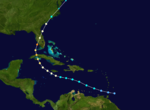 Hurricane Charley began as a tropical wave
that moved off the west coast of Africa in early August 2004. Tracking westward, the system gradually organized and was declared a tropical depression on August 9 while located roughly 115 mi (185 km) south-southeast of Barbados
. The following day, the depression intensified into a tropical storm and was given the name Charley after entering the eastern Caribbean Sea
. Quickly tracking northwest, the small storm intensified.
Late on August 11, as Charley traveled south of Jamaica, it attained hurricane intensity, with winds reaching 75 mph (120 km/h). Over the following days, the storm curved northeast and impacted western Cuba as a Category 3 hurricane before striking Florida
as an intense Category 4 hurricane with winds up to 150 mph (240 km/h) on August 13. The weakened Charley rapidly tracked northeast before dissipating on August 15 near Long Island
, New York
.
(NHC), based in Miami, Florida
, issued a tropical storm watch
for the entire island of Jamaica as Tropical Storm Charley intensified over the eastern Caribbean Sea
. Later that day, the watch was upgraded to a warning as the storm quickly approached the island. Early on August 11, a hurricane watch was declared for the island as Charley neared hurricane intensity. Late on August 11, all watches and warnings for Jamaica were changed to hurricane warnings as Charley attained Category 1 status on the Saffir–Simpson Hurricane Scale. The warning was later discontinued on August 12 as Hurricane Charley tracked towards Cuba, no longer a threat to Jamaica.
Following the issuance of hurricane watches, Robert Pickersgill, Minister of Transport and Works in Jamaica closed both airports, Norman Manley International Airport
and Sangster International Airport, on the island and shut down all ports. A total of 33 flights were canceled or delayed by the storm. Roughly 3,000 passengers from the Carnival Conquest
cruise ship were diverted from their scheduled arrival in Montego Bay
, resulting in millions of dollars in losses. Another cruise ship, The Triumph, carrying 2,700 passengers was also diverted. Most businesses on the island were closed on August 12. Emergency shelters were set up across the island ahead of the storm; however, press reports indicate that no one sought refuge in shelters. Residents along the coast were urged to evacuate by the Office of Disaster Preparedness and Emergency Management due to the risk of storm surge
and large swells that could inundate low-lying communities. Up to 6 in (152.4 mm) of rain fell in eastern portions of the island, triggering mudslides.
On August 11, the Jamaica Red Cross opened its Emergency Operations Center in preparation for Hurricane Charley and placed the warning level at one, the lowest warning level. Residents throughout the country stocked up on emergency supplies and non-perishable food, noted by an increase in sales at shops. In Saint James Parish
, emergency officials activated all necessary agencies by August 11. Late on August 11, emergency officials quickly opened 50 shelters in the parish. In Saint Elizabeth Parish, 100 residents sought refuge in the six shelters opened throughout the parish. A total of $1.5 million (JMD; $17,000 USD) was allocated by the Ministry of Local Government for repairs after the storm. The Jamaica Red Cross alerted local branches to be prepared as Charley approached.
. The Jamaica Defence Force Coast Guard rescued the crew members the following day and brought them to Kingston Public Hospital as they were severely dehydrated and exhausted. During the preparations, storms ahead of the hurricane knocked out power in isolated areas. After nearly completing restoration of the initial power outage, lightning
struck a power line and left more residents without electricity..
The community of Big Woods was significantly affected by flooding, with 30 families being isolated in the area. The only fatality from the storm also occurred in this community after a man was washed away while trying to rescue a family. The severity of damage in Big Woods prompted Jamaica Labour Party Area Council Four chairman to state that it should be declared a disaster area. Torrential rains during a two-hour span overnight triggered most of the flooding in the area, isolating many homes and inundating several. In Westmoreland Parish, severe flooding inundated several homes and damaged roadways. One home sustained significant damage after a large tree fell on it. In Kingston
, high winds damaged power lines and some homes. Water supply to most regions was cut due to damage to pipelines and high water turbidity
. Widespread power outages occurred due to numerous downed trees and power lines.
The banana industry sustained severe losses, with trees downed and fruit damaged and numerous livestock drowned in flood waters. Initial assessments of agricultural losses from the storm reached $300 million (JMD; $3.4 million USD). Residents requested the government for immediate assistance as families were without a source of food and income. Official assessments in four parishes placed the damage to agriculture and livestock at $88.4 million (JMD; $1 million USD), with roughly $73.5 million (JMD; $835,000 USD) of this accounting for 750 farmers in Saint Elizabeth.
Roads in Saint Elizabeth sustained substantial damage, with 32 separate roads experiencing severe impacts. Throughout the country, a total of $7.6 million (JMD
; $86,000 USD
) was provided to repair the roads, $4.23 million (JMD; $48,000 USD) of which was used in Saint Elizabeth alone. Widespread damage to crops also resulted in an increased price in store costs. The loss to farmers was untimely as it followed a three month drought that was preceded by damaging hailstorms that ruined crops. Following the storm, search and rescue teams were deployed, mainly in Saint Elizabeth Parish following reports of flooding.
Tropical wave
Tropical waves, easterly waves, or tropical easterly waves, also known as African easterly waves in the Atlantic region, are a type of atmospheric trough, an elongated area of relatively low air pressure, oriented north to south, which move from east to west across the tropics causing areas of...
on August 9, 2004, Charley quickly tracked through the eastern Caribbean Sea
Caribbean Sea
The Caribbean Sea is a sea of the Atlantic Ocean located in the tropics of the Western hemisphere. It is bounded by Mexico and Central America to the west and southwest, to the north by the Greater Antilles, and to the east by the Lesser Antilles....
and attained tropical storm status on August 10. While passing south of Jamaica on August 11, the storm was upgraded to a Category 1 hurricane. During its passage of Jamaica, Charley had maximum winds of 75 mph (120 km/h), a low-end Category 1 hurricane. Turning north, the storm impacted western Cuba as a Category 3 storm before making landfall in Florida as a strong Category 4. The storm eventually dissipated on August 15. As Charley approached Jamaica, officials issued tropical storm watches and warnings before issuing a hurricane watch. Two cruise ships were diverted from docking in Jamaica, affecting 5,700 passengers. Numerous shelters were set up across the island; however, relatively few people sought refuge in them.
Although it was only a Category 1 hurricane, Charley caused significant damage in southern Jamaica. Saint Elizabeth Parish sustained the worst damage. About 750 farmers reported damage, and at one point, flooding isolated 30 families. The only fatality in Jamaica occurred after a man attempted to rescue a family but was swept away by flood waters. Following the storm, search and rescue teams were deployed to flooded regions. Days later, officials allocated roughly $7.6 million (JMD
Jamaican dollar
The dollar has been the currency of Jamaica since 1969. It is often abbreviated "J$", the J serving to distinguish it from other dollar-denominated currencies. It is divided into 100 cents.-History:...
; $86,000 USD
United States dollar
The United States dollar , also referred to as the American dollar, is the official currency of the United States of America. It is divided into 100 smaller units called cents or pennies....
) to repair damaged roads. Residents in areas that sustained severe agricultural losses also requested assistance from the government.
Background
Tropical wave
Tropical waves, easterly waves, or tropical easterly waves, also known as African easterly waves in the Atlantic region, are a type of atmospheric trough, an elongated area of relatively low air pressure, oriented north to south, which move from east to west across the tropics causing areas of...
that moved off the west coast of Africa in early August 2004. Tracking westward, the system gradually organized and was declared a tropical depression on August 9 while located roughly 115 mi (185 km) south-southeast of Barbados
Barbados
Barbados is an island country in the Lesser Antilles. It is in length and as much as in width, amounting to . It is situated in the western area of the North Atlantic and 100 kilometres east of the Windward Islands and the Caribbean Sea; therein, it is about east of the islands of Saint...
. The following day, the depression intensified into a tropical storm and was given the name Charley after entering the eastern Caribbean Sea
Caribbean Sea
The Caribbean Sea is a sea of the Atlantic Ocean located in the tropics of the Western hemisphere. It is bounded by Mexico and Central America to the west and southwest, to the north by the Greater Antilles, and to the east by the Lesser Antilles....
. Quickly tracking northwest, the small storm intensified.
Late on August 11, as Charley traveled south of Jamaica, it attained hurricane intensity, with winds reaching 75 mph (120 km/h). Over the following days, the storm curved northeast and impacted western Cuba as a Category 3 hurricane before striking Florida
Florida
Florida is a state in the southeastern United States, located on the nation's Atlantic and Gulf coasts. It is bordered to the west by the Gulf of Mexico, to the north by Alabama and Georgia and to the east by the Atlantic Ocean. With a population of 18,801,310 as measured by the 2010 census, it...
as an intense Category 4 hurricane with winds up to 150 mph (240 km/h) on August 13. The weakened Charley rapidly tracked northeast before dissipating on August 15 near Long Island
Long Island
Long Island is an island located in the southeast part of the U.S. state of New York, just east of Manhattan. Stretching northeast into the Atlantic Ocean, Long Island contains four counties, two of which are boroughs of New York City , and two of which are mainly suburban...
, New York
New York
New York is a state in the Northeastern region of the United States. It is the nation's third most populous state. New York is bordered by New Jersey and Pennsylvania to the south, and by Connecticut, Massachusetts and Vermont to the east...
.
Preparations
On August 10, the National Hurricane CenterNational Hurricane Center
The National Hurricane Center , located at Florida International University in Miami, Florida, is the division of the National Weather Service responsible for tracking and predicting weather systems within the tropics between the Prime Meridian and the 140th meridian west poleward to the 30th...
(NHC), based in Miami, Florida
Miami, Florida
Miami is a city located on the Atlantic coast in southeastern Florida and the county seat of Miami-Dade County, the most populous county in Florida and the eighth-most populous county in the United States with a population of 2,500,625...
, issued a tropical storm watch
Tropical cyclone warnings and watches
Warnings and watches are two levels of alert issued by national weather forecasting bodies to coastal areas threatened by the imminent approach of a tropical cyclone of tropical storm or hurricane intensity. They are notices to the local population and civil authorities to make appropriate...
for the entire island of Jamaica as Tropical Storm Charley intensified over the eastern Caribbean Sea
Caribbean Sea
The Caribbean Sea is a sea of the Atlantic Ocean located in the tropics of the Western hemisphere. It is bounded by Mexico and Central America to the west and southwest, to the north by the Greater Antilles, and to the east by the Lesser Antilles....
. Later that day, the watch was upgraded to a warning as the storm quickly approached the island. Early on August 11, a hurricane watch was declared for the island as Charley neared hurricane intensity. Late on August 11, all watches and warnings for Jamaica were changed to hurricane warnings as Charley attained Category 1 status on the Saffir–Simpson Hurricane Scale. The warning was later discontinued on August 12 as Hurricane Charley tracked towards Cuba, no longer a threat to Jamaica.
Following the issuance of hurricane watches, Robert Pickersgill, Minister of Transport and Works in Jamaica closed both airports, Norman Manley International Airport
Norman Manley International Airport
-Cargo :The following Cargo/Courier serve Norman Manley International Airport:-Accidents and incidents:*On 17 July 1960, the captain of a Vickers Viscount of Cubana de Aviación hijacked the aircraft on a flight from José Martí International Airport, Havana to Miami International Airport, Florida...
and Sangster International Airport, on the island and shut down all ports. A total of 33 flights were canceled or delayed by the storm. Roughly 3,000 passengers from the Carnival Conquest
Carnival Conquest
Carnival Conquest is a Conquest-class cruise ship owned and operated by Carnival Cruise Lines. Sixty percent of her staterooms have ocean views, and sixty percent of those have balconies. Carnival Conquest cruises the Western Caribbean from the port of Galveston, Texas...
cruise ship were diverted from their scheduled arrival in Montego Bay
Montego Bay
Montego Bay is the capital of St. James Parish and the second largest city in Jamaica by area and the fourth by population .It is a tourist destination with duty free shopping, cruise line terminal and the beaches...
, resulting in millions of dollars in losses. Another cruise ship, The Triumph, carrying 2,700 passengers was also diverted. Most businesses on the island were closed on August 12. Emergency shelters were set up across the island ahead of the storm; however, press reports indicate that no one sought refuge in shelters. Residents along the coast were urged to evacuate by the Office of Disaster Preparedness and Emergency Management due to the risk of storm surge
Storm surge
A storm surge is an offshore rise of water associated with a low pressure weather system, typically tropical cyclones and strong extratropical cyclones. Storm surges are caused primarily by high winds pushing on the ocean's surface. The wind causes the water to pile up higher than the ordinary sea...
and large swells that could inundate low-lying communities. Up to 6 in (152.4 mm) of rain fell in eastern portions of the island, triggering mudslides.
On August 11, the Jamaica Red Cross opened its Emergency Operations Center in preparation for Hurricane Charley and placed the warning level at one, the lowest warning level. Residents throughout the country stocked up on emergency supplies and non-perishable food, noted by an increase in sales at shops. In Saint James Parish
Saint James Parish, Jamaica
St James is a suburban parish, located on the north west end of the island of Jamaica. Its capital, Montego Bay, derived from the Spanish word Manteca because many wild hogs were found there from which they made lard. It was named publicly the second city of Jamaica, behind Kingston, in 1981....
, emergency officials activated all necessary agencies by August 11. Late on August 11, emergency officials quickly opened 50 shelters in the parish. In Saint Elizabeth Parish, 100 residents sought refuge in the six shelters opened throughout the parish. A total of $1.5 million (JMD; $17,000 USD) was allocated by the Ministry of Local Government for repairs after the storm. The Jamaica Red Cross alerted local branches to be prepared as Charley approached.
Impact and aftermath
On August 11, a 60 ft (18.3 m) yacht carrying three people was disabled roughly 58 mi (93 km) southeast of the Morant CaysMorant Cays
Morant Cays is an offshore island group 51 km SSE off Morant Point, Jamaica. They are one of two offshore island groups belonging to Jamaica, the other ones being the Pedro Cays...
. The Jamaica Defence Force Coast Guard rescued the crew members the following day and brought them to Kingston Public Hospital as they were severely dehydrated and exhausted. During the preparations, storms ahead of the hurricane knocked out power in isolated areas. After nearly completing restoration of the initial power outage, lightning
Lightning
Lightning is an atmospheric electrostatic discharge accompanied by thunder, which typically occurs during thunderstorms, and sometimes during volcanic eruptions or dust storms...
struck a power line and left more residents without electricity..
The community of Big Woods was significantly affected by flooding, with 30 families being isolated in the area. The only fatality from the storm also occurred in this community after a man was washed away while trying to rescue a family. The severity of damage in Big Woods prompted Jamaica Labour Party Area Council Four chairman to state that it should be declared a disaster area. Torrential rains during a two-hour span overnight triggered most of the flooding in the area, isolating many homes and inundating several. In Westmoreland Parish, severe flooding inundated several homes and damaged roadways. One home sustained significant damage after a large tree fell on it. In Kingston
Kingston, Jamaica
Kingston is the capital and largest city of Jamaica, located on the southeastern coast of the island. It faces a natural harbour protected by the Palisadoes, a long sand spit which connects the town of Port Royal and the Norman Manley International Airport to the rest of the island...
, high winds damaged power lines and some homes. Water supply to most regions was cut due to damage to pipelines and high water turbidity
Turbidity
Turbidity is the cloudiness or haziness of a fluid caused by individual particles that are generally invisible to the naked eye, similar to smoke in air. The measurement of turbidity is a key test of water quality....
. Widespread power outages occurred due to numerous downed trees and power lines.
The banana industry sustained severe losses, with trees downed and fruit damaged and numerous livestock drowned in flood waters. Initial assessments of agricultural losses from the storm reached $300 million (JMD; $3.4 million USD). Residents requested the government for immediate assistance as families were without a source of food and income. Official assessments in four parishes placed the damage to agriculture and livestock at $88.4 million (JMD; $1 million USD), with roughly $73.5 million (JMD; $835,000 USD) of this accounting for 750 farmers in Saint Elizabeth.
Roads in Saint Elizabeth sustained substantial damage, with 32 separate roads experiencing severe impacts. Throughout the country, a total of $7.6 million (JMD
Jamaican dollar
The dollar has been the currency of Jamaica since 1969. It is often abbreviated "J$", the J serving to distinguish it from other dollar-denominated currencies. It is divided into 100 cents.-History:...
; $86,000 USD
United States dollar
The United States dollar , also referred to as the American dollar, is the official currency of the United States of America. It is divided into 100 smaller units called cents or pennies....
) was provided to repair the roads, $4.23 million (JMD; $48,000 USD) of which was used in Saint Elizabeth alone. Widespread damage to crops also resulted in an increased price in store costs. The loss to farmers was untimely as it followed a three month drought that was preceded by damaging hailstorms that ruined crops. Following the storm, search and rescue teams were deployed, mainly in Saint Elizabeth Parish following reports of flooding.
See also
- Hurricane CharleyHurricane CharleyHurricane Charley was the third named storm, the second hurricane, and the second major hurricane of the 2004 Atlantic hurricane season. Charley lasted from August 9 to August 15, and at its peak intensity it attained 150 mph winds, making it a strong Category 4 hurricane on the...
- Effects of Hurricane Ivan in JamaicaEffects of Hurricane Ivan in JamaicaThe effects of Hurricane Ivan in Jamaica were among the worst from a tropical cyclone in the island's recorded history. Hurricane Ivan formed as a Cape Verde-type hurricane in early September 2004 and became the ninth named storm, the sixth hurricane, and the fourth major hurricane of the year...
- 2004 Atlantic hurricane season2004 Atlantic hurricane seasonThe 2004 Atlantic hurricane season officially began on June 1, 2004, and lasted until November 30, 2004. These dates conventionally delimit the period of each year when most tropical cyclones form in the Atlantic basin...