
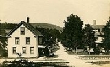
Eaton, New Hampshire
Encyclopedia
Eaton is a town
in Carroll County
, New Hampshire
, United States
. The population was 393 at the 2010 census. Eaton includes the village of Snowville.
 Eaton was incorporated in 1760 by Colonial
Governor Benning Wentworth
, and named for Governor Theophilus Eaton
of Connecticut
, a generous contributor to the funds needed to settle Massachusetts
in 1630. He later formed a colony at New Haven
, Connecticut
, along with Reverend John Davenport
and David Yale, great-grandfather of Yale University's
founder, Elihu Yale
.
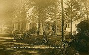
The "Little White Church" is a town landmark. The village of Snowville is named for the Snow family, who started a sawmill
there in 1825. "Waukeela", a summer camp for girls, has been in Eaton for 90 years as of 2011. It occupies 45 acres (182,108.7 m²) on Crystal Lake.
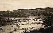
, the town has a total area of 25.6 square miles (66.3 km²), of which 24.3 square miles (62.9 km²) is land and 1.3 square miles (3.4 km²) is water, comprising 5.06% of the town. Conway Lake
is on the northern boundary, and Crystal Lake is in the center. Eaton lies fully within the Saco River
watershed
. The highest point in town is 1730 feet (527.3 m) above sea level
on its southern boundary, just north of the 1806 feet (550.5 m) summit of Cragged Mountain. Eaton is bounded on the east by the Maine
state line.
 As of the census
of 2000, there were 375 people, 157 households, and 111 families residing in the town. The population density
was 15.4 people per square mile (5.9/km²). There were 239 housing units at an average density of 9.8 per square mile (3.8/km²). The racial makeup of the town was 98.67% White, 0.27% African American, 0.27% Asian, and 0.80% from two or more races.
There were 157 households out of which 29.9% had children under the age of 18 living with them, 61.1% were married couples
living together, 7.6% had a female householder with no husband present, and 28.7% were non-families. 23.6% of all households were made up of individuals and 7.0% had someone living alone who was 65 years of age or older. The average household size was 2.38 and the average family size was 2.85.
 In the town the population was spread out with 23.5% under the age of 18, 4.0% from 18 to 24, 21.6% from 25 to 44, 38.9% from 45 to 64, and 12.0% who were 65 years of age or older. The median age was 45 years. For every 100 females there were 96.3 males. For every 100 females age 18 and over, there were 92.6 males.
The median income for a household in the town was $46,429, and the median income for a family was $53,750. Males had a median income of $31,458 versus $23,750 for females. The per capita income
for the town was $21,122. About 3.6% of families and 7.2% of the population were below the poverty line, including 7.6% of those under age 18 and 15.9% of those age 65 or over.
New England town
The New England town is the basic unit of local government in each of the six New England states. Without a direct counterpart in most other U.S. states, New England towns are conceptually similar to civil townships in other states, but are incorporated, possessing powers like cities in other...
in Carroll County
Carroll County, New Hampshire
-Demographics:As of the census of 2000, there were 43,666 people, 18,351 households, and 12,313 families residing in the county. The population density was 18/km² . There were 34,750 housing units at an average density of 14/km²...
, New Hampshire
New Hampshire
New Hampshire is a state in the New England region of the northeastern United States of America. The state was named after the southern English county of Hampshire. It is bordered by Massachusetts to the south, Vermont to the west, Maine and the Atlantic Ocean to the east, and the Canadian...
, United States
United States
The United States of America is a federal constitutional republic comprising fifty states and a federal district...
. The population was 393 at the 2010 census. Eaton includes the village of Snowville.
History
Colony
In politics and history, a colony is a territory under the immediate political control of a state. For colonies in antiquity, city-states would often found their own colonies. Some colonies were historically countries, while others were territories without definite statehood from their inception....
Governor Benning Wentworth
Benning Wentworth
Benning Wentworth was the colonial governor of New Hampshire from 1741 to 1766.-Biography:The eldest child of the John Wentworth who had been Lieutenant Governor, he was born and died in Portsmouth, New Hampshire. Wentworth graduated from Harvard College in 1715...
, and named for Governor Theophilus Eaton
Theophilus Eaton
Theophilus Eaton was a merchant, farmer, and Puritan colonial leader who was the co-founder and first governor of New Haven Colony, Connecticut.-Early life and first marriage:...
of Connecticut
Connecticut
Connecticut is a state in the New England region of the northeastern United States. It is bordered by Rhode Island to the east, Massachusetts to the north, and the state of New York to the west and the south .Connecticut is named for the Connecticut River, the major U.S. river that approximately...
, a generous contributor to the funds needed to settle Massachusetts
Massachusetts
The Commonwealth of Massachusetts is a state in the New England region of the northeastern United States of America. It is bordered by Rhode Island and Connecticut to the south, New York to the west, and Vermont and New Hampshire to the north; at its east lies the Atlantic Ocean. As of the 2010...
in 1630. He later formed a colony at New Haven
New Haven, Connecticut
New Haven is the second-largest city in Connecticut and the sixth-largest in New England. According to the 2010 Census, New Haven's population increased by 5.0% between 2000 and 2010, a rate higher than that of the State of Connecticut, and higher than that of the state's five largest cities, and...
, Connecticut
Connecticut
Connecticut is a state in the New England region of the northeastern United States. It is bordered by Rhode Island to the east, Massachusetts to the north, and the state of New York to the west and the south .Connecticut is named for the Connecticut River, the major U.S. river that approximately...
, along with Reverend John Davenport
John Davenport (clergyman)
John Davenport was an English puritan clergyman and co-founder of the American colony of New Haven.-Early life:Born in Manchester, Warwickshire, England to a wealthy family, Davenport was educated at Oxford University...
and David Yale, great-grandfather of Yale University's
Yale University
Yale University is a private, Ivy League university located in New Haven, Connecticut, United States. Founded in 1701 in the Colony of Connecticut, the university is the third-oldest institution of higher education in the United States...
founder, Elihu Yale
Elihu Yale
Elihu Yale was a Welsh merchant and philanthropist, governor of the East India Company, and a benefactor of the Collegiate School of Connecticut, which in 1718 was named Yale College in his honour.- Life :...
.
The "Little White Church" is a town landmark. The village of Snowville is named for the Snow family, who started a sawmill
Sawmill
A sawmill is a facility where logs are cut into boards.-Sawmill process:A sawmill's basic operation is much like those of hundreds of years ago; a log enters on one end and dimensional lumber exits on the other end....
there in 1825. "Waukeela", a summer camp for girls, has been in Eaton for 90 years as of 2011. It occupies 45 acres (182,108.7 m²) on Crystal Lake.
Geography
According to the United States Census BureauUnited States Census Bureau
The United States Census Bureau is the government agency that is responsible for the United States Census. It also gathers other national demographic and economic data...
, the town has a total area of 25.6 square miles (66.3 km²), of which 24.3 square miles (62.9 km²) is land and 1.3 square miles (3.4 km²) is water, comprising 5.06% of the town. Conway Lake
Conway Lake
Conway Lake is a water body located in Carroll County in eastern New Hampshire, in the United States. The lake is located in the towns of Conway and Eaton, just to the east of the White Mountains and is part of the Saco River watershed.-History:...
is on the northern boundary, and Crystal Lake is in the center. Eaton lies fully within the Saco River
Saco River
The Saco River is a river in northeastern New Hampshire and southwestern Maine in the United States. It drains a rural area of of forests and farmlands west and southwest of Portland, emptying into the Atlantic Ocean at Saco Bay, from its source. It supplies drinking water to roughly 250,000...
watershed
Drainage basin
A drainage basin is an extent or an area of land where surface water from rain and melting snow or ice converges to a single point, usually the exit of the basin, where the waters join another waterbody, such as a river, lake, reservoir, estuary, wetland, sea, or ocean...
. The highest point in town is 1730 feet (527.3 m) above sea level
Sea level
Mean sea level is a measure of the average height of the ocean's surface ; used as a standard in reckoning land elevation...
on its southern boundary, just north of the 1806 feet (550.5 m) summit of Cragged Mountain. Eaton is bounded on the east by the Maine
Maine
Maine is a state in the New England region of the northeastern United States, bordered by the Atlantic Ocean to the east and south, New Hampshire to the west, and the Canadian provinces of Quebec to the northwest and New Brunswick to the northeast. Maine is both the northernmost and easternmost...
state line.
Demographics
Census
A census is the procedure of systematically acquiring and recording information about the members of a given population. It is a regularly occurring and official count of a particular population. The term is used mostly in connection with national population and housing censuses; other common...
of 2000, there were 375 people, 157 households, and 111 families residing in the town. The population density
Population density
Population density is a measurement of population per unit area or unit volume. It is frequently applied to living organisms, and particularly to humans...
was 15.4 people per square mile (5.9/km²). There were 239 housing units at an average density of 9.8 per square mile (3.8/km²). The racial makeup of the town was 98.67% White, 0.27% African American, 0.27% Asian, and 0.80% from two or more races.
There were 157 households out of which 29.9% had children under the age of 18 living with them, 61.1% were married couples
Marriage
Marriage is a social union or legal contract between people that creates kinship. It is an institution in which interpersonal relationships, usually intimate and sexual, are acknowledged in a variety of ways, depending on the culture or subculture in which it is found...
living together, 7.6% had a female householder with no husband present, and 28.7% were non-families. 23.6% of all households were made up of individuals and 7.0% had someone living alone who was 65 years of age or older. The average household size was 2.38 and the average family size was 2.85.
The median income for a household in the town was $46,429, and the median income for a family was $53,750. Males had a median income of $31,458 versus $23,750 for females. The per capita income
Per capita income
Per capita income or income per person is a measure of mean income within an economic aggregate, such as a country or city. It is calculated by taking a measure of all sources of income in the aggregate and dividing it by the total population...
for the town was $21,122. About 3.6% of families and 7.2% of the population were below the poverty line, including 7.6% of those under age 18 and 15.9% of those age 65 or over.