
Drakes Estero
Encyclopedia
Drakes Estero is an expansive estuary
in Marin County
on the Pacific
coast of northern California
in the United States
, approximately 25 miles (40.2 km) northwest of San Francisco
.
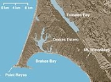
 Located at 38.047°N 122.942°W, the estuary provides the main drainage for the Point Reyes
peninsula. Seen from the air, Drakes Estero resembles a human hand, with Barries Bay, Creamery Bay, Schooner Bay, and Home Bay as the "fingers" and Limantour Bay as the thumb. The waters of the Estero flow into Drakes Bay
between Drakes Beach and a narrow strip of land called Limantour Spit.
Drakes Estero is protected as part of the Point Reyes National Seashore
and recognized for protection by the California Bays and Estuaries Policy
.
on the coast of North America
in 1579 during his circumnavigation
of the world. The determination of the site, however, remains controversial. A historical marker has been placed on Drakes Beach near the Kenneth C. Patrick Visitor Center.
Estuary
An estuary is a partly enclosed coastal body of water with one or more rivers or streams flowing into it, and with a free connection to the open sea....
in Marin County
Marin County, California
Marin County is a county located in the North San Francisco Bay Area of the U.S. state of California, across the Golden Gate Bridge from San Francisco. As of 2010, the population was 252,409. The county seat is San Rafael and the largest employer is the county government. Marin County is well...
on the Pacific
Pacific Ocean
The Pacific Ocean is the largest of the Earth's oceanic divisions. It extends from the Arctic in the north to the Southern Ocean in the south, bounded by Asia and Australia in the west, and the Americas in the east.At 165.2 million square kilometres in area, this largest division of the World...
coast of northern California
California
California is a state located on the West Coast of the United States. It is by far the most populous U.S. state, and the third-largest by land area...
in the United States
United States
The United States of America is a federal constitutional republic comprising fifty states and a federal district...
, approximately 25 miles (40.2 km) northwest of San Francisco
San Francisco, California
San Francisco , officially the City and County of San Francisco, is the financial, cultural, and transportation center of the San Francisco Bay Area, a region of 7.15 million people which includes San Jose and Oakland...
.
Point Reyes
Point Reyes is a prominent cape on the Pacific coast of northern California. It is located in Marin County approximately WNW of San Francisco. The term is often applied to the Point Reyes Peninsula, the region bounded by Tomales Bay on the northeast and Bolinas Lagoon on the southeast...
peninsula. Seen from the air, Drakes Estero resembles a human hand, with Barries Bay, Creamery Bay, Schooner Bay, and Home Bay as the "fingers" and Limantour Bay as the thumb. The waters of the Estero flow into Drakes Bay
Drakes Bay
Drakes Bay is a small bay on the coast of northern California in the United States, approximately 30 miles northwest of San Francisco at approximately 38 degrees north latitude. The bay is approximately 8 miles wide...
between Drakes Beach and a narrow strip of land called Limantour Spit.
Drakes Estero is protected as part of the Point Reyes National Seashore
Point Reyes National Seashore
Point Reyes National Seashore is a park preserve located on the Point Reyes Peninsula in Marin County, California, USA. As a national seashore, it is maintained by the US National Park Service as a nationally important nature preserve within which existing agricultural uses are allowed to continue...
and recognized for protection by the California Bays and Estuaries Policy
California Bays and Estuaries Policy
The Water Quality Control Policy for the Enclosed Bays and Estuaries of California is published by the California State Water Resources Control Board as guidelines to prevent water quality degradation. The policy is revised as needed.-Geography:...
.
History
Drakes Estero is considered by many historians to be the most likely landing spot of Francis DrakeFrancis Drake
Sir Francis Drake, Vice Admiral was an English sea captain, privateer, navigator, slaver, and politician of the Elizabethan era. Elizabeth I of England awarded Drake a knighthood in 1581. He was second-in-command of the English fleet against the Spanish Armada in 1588. He also carried out the...
on the coast of North America
North America
North America is a continent wholly within the Northern Hemisphere and almost wholly within the Western Hemisphere. It is also considered a northern subcontinent of the Americas...
in 1579 during his circumnavigation
Circumnavigation
Circumnavigation – literally, "navigation of a circumference" – refers to travelling all the way around an island, a continent, or the entire planet Earth.- Global circumnavigation :...
of the world. The determination of the site, however, remains controversial. A historical marker has been placed on Drakes Beach near the Kenneth C. Patrick Visitor Center.
See also
- Abbotts LagoonAbbotts LagoonAbbotts Lagoon is a two-stage lagoon near the western coast of the Point Reyes National Seashore. The upper lagoon is a fresh water impoundment which overflows into a lower brackish level with occasional winter tidal exchange...
- Bolinas LagoonBolinas LagoonBolinas Lagoon is a tidal estuary, approximately in area, located at in the West Marin region of Marin County, California, United States. It is a part of the Gulf of the Farallones National Marine Sanctuary. The lagoon is a back bay of Bolinas Bay on the Pacific coast approximately 15 mi ...
- New AlbionNew AlbionNew Albion, also known as Nova Albion, was the name of the region of the Pacific coast of North America explored by Sir Francis Drake and claimed by him for England in 1579...
- Tomales BayTomales BayTomales Bay is a long narrow inlet of the Pacific Ocean in Marin County in northern California in the United States. It is approximately 15 miles long and averages nearly 1.0 miles wide, effectively separating the Point Reyes Peninsula from the mainland of Marin County. It is located...