
Point Reyes
Encyclopedia
Cape (geography)
In geography, a cape or headland is a point or body of land extending into a body of water, usually the sea.A cape usually represents a marked change in trend of the coastline. Their proximity to the coastline makes them prone to natural forms of erosion, mainly tidal actions. This results in capes...
on the Pacific
Pacific Ocean
The Pacific Ocean is the largest of the Earth's oceanic divisions. It extends from the Arctic in the north to the Southern Ocean in the south, bounded by Asia and Australia in the west, and the Americas in the east.At 165.2 million square kilometres in area, this largest division of the World...
coast of northern California
California
California is a state located on the West Coast of the United States. It is by far the most populous U.S. state, and the third-largest by land area...
. It is located in Marin County
Marin County, California
Marin County is a county located in the North San Francisco Bay Area of the U.S. state of California, across the Golden Gate Bridge from San Francisco. As of 2010, the population was 252,409. The county seat is San Rafael and the largest employer is the county government. Marin County is well...
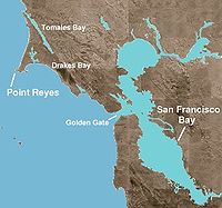
approximately 30 miles (48.3 km) WNW of San Francisco. The term is often applied to the Point Reyes Peninsula, the region bounded by Tomales Bay
Tomales Bay
Tomales Bay is a long narrow inlet of the Pacific Ocean in Marin County in northern California in the United States. It is approximately 15 miles long and averages nearly 1.0 miles wide, effectively separating the Point Reyes Peninsula from the mainland of Marin County. It is located...
on the northeast and Bolinas Lagoon
Bolinas Lagoon
Bolinas Lagoon is a tidal estuary, approximately in area, located at in the West Marin region of Marin County, California, United States. It is a part of the Gulf of the Farallones National Marine Sanctuary. The lagoon is a back bay of Bolinas Bay on the Pacific coast approximately 15 mi ...
on the southeast. The headland is protected as part of Point Reyes National Seashore
Point Reyes National Seashore
Point Reyes National Seashore is a park preserve located on the Point Reyes Peninsula in Marin County, California, USA. As a national seashore, it is maintained by the US National Park Service as a nationally important nature preserve within which existing agricultural uses are allowed to continue...
.
Overview
The cape protects Drakes BayDrakes Bay
Drakes Bay is a small bay on the coast of northern California in the United States, approximately 30 miles northwest of San Francisco at approximately 38 degrees north latitude. The bay is approximately 8 miles wide...
on its southern side. The headland is largely drained by Drakes Estero
Drakes Estero
Drakes Estero is an expansive estuary in Marin County on the Pacific coast of northern California in the United States, approximately northwest of San Francisco.Located at , the estuary provides the main drainage for the Point Reyes peninsula...
. Drake's Bay and Drake's Estero are named after English seafarer Sir Francis Drake
Francis Drake
Sir Francis Drake, Vice Admiral was an English sea captain, privateer, navigator, slaver, and politician of the Elizabethan era. Elizabeth I of England awarded Drake a knighthood in 1581. He was second-in-command of the English fleet against the Spanish Armada in 1588. He also carried out the...
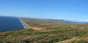
who possibly hauled his ship, the Golden Hinde, up onto the beach for repairs in June of 1579. Inverness Ridge runs along the peninsula's northwest-southeast spine, with forested peaks around 430 meters (1,400 ft). West of the ridge, the land flattens out and the vegetation turns to scrub. The Mount Vision fire
Mount Vision fire
The Mount Vision fire was a wildfire that burned for 4 days in October, 1995 on the Point Reyes peninsula in northern California. Over 12,000 acres were burned, mostly within the Point Reyes National Seashore, and 45 Inverness Park homes were destroyed...
in 1995 burned part of Inverness Ridge
Inverness Ridge
Inverness Ridge is a ridge located at on the Point Reyes Peninsula in western Marin County, California. It reaches an elevation of .-See also:* Inverness* Inverness Park* Bolinas Ridge...
.
Point Reyes lends its name to the town of Point Reyes Station, California
Point Reyes Station, California
Point Reyes Station is small unincorporated town located in western Marin County, California. Point Reyes Station is located south-southeast of Tomales, at an elevation of . Point Reyes Station is located along State Route 1 and is a gateway to the Point Reyes National Seashore, an extremely...
.
The point may once have been known as Lobes Lighthouse by the sailors of clipper ships on the meat trade. (Lobes are ridges of slide material commonly referred in the literature from erosion events and the point is of that shape out to sea).
History
Sebastián Vizcaíno
Sebastián Vizcaíno was a Spanish soldier, entrepreneur, explorer, and diplomat whose varied roles took him to New Spain, the Philippines, the Baja California peninsula, the California coast and Japan.-Early career:...
as his ship, the Capitana anchored in Drake's Bay on the Day of the Three Kings (Epiphany, or the end of the 12 Days of Christmas) on January 6, 1603. Although Sir Francis Drake landed somewhere near the area on June 17, 1579 and proclaimed it Nova Albion (New England), the exact location of his landing remains controversial.
During the Cold War
Cold War
The Cold War was the continuing state from roughly 1946 to 1991 of political conflict, military tension, proxy wars, and economic competition between the Communist World—primarily the Soviet Union and its satellite states and allies—and the powers of the Western world, primarily the United States...
, submarines repaired at Mare Island Naval Shipyard
Mare Island Naval Shipyard
The Mare Island Naval Shipyard was the first United States Navy base established on the Pacific Ocean. It is located 25 miles northeast of San Francisco in Vallejo, California. The Napa River goes through the Mare Island Strait and separates the peninsula shipyard from the main portion of the...
were tested in the shallow waters off Point Reyes following shipyard repairs. Navy safety personnel used a small monitoring and communications hut on the peninsula for monitoring submarines during these sea trial
Sea trial
A sea trial is the testing phase of a watercraft . It is also referred to as a "shakedown cruise" by many naval personnel. It is usually the last phase of construction and takes place on open water, and can last from a few hours to many days.Sea trials are conducted to measure a vessel’s...
s.
In April and May 1979, part of John Carpenter
John Carpenter
John Howard Carpenter is an American film director, screenwriter, producer, editor, composer, and occasional actor. Although Carpenter has worked in numerous film genres in his four-decade career, his name is most commonly associated with horror and science fiction.- Early life :Carpenter was born...
's The Fog
The Fog
The Fog is a 1980 horror film directed by John Carpenter, who also co-wrote the screenplay and composed the music for the film. It stars Adrienne Barbeau, Jamie Lee Curtis, Tom Atkins and Janet Leigh...
was shot at the Point Reyes Lighthouse and the small town of Inverness
Inverness, California
Inverness is an unincorporated community and census-designated place located in western Marin County, California. Inverness is located on the southwest shore of Tomales Bay northwest of Point Reyes Station, at an elevation of 43 feet . In the 2010 census, the population was 1,304...
.
Ecology
Two large mammalian species, nearly extirpatedLocal extinction
Local extinction, also known as extirpation, is the condition of a species which ceases to exist in the chosen geographic area of study, though it still exists elsewhere...
in the nineteenth century, have made a remarkable recovery at Point Reyes: the Northern elephant seal
Northern Elephant Seal
The northern elephant seal is one of two species of elephant seal . It is a member of the family Phocidae . Elephant seals derive their name from their great size and from the male's large proboscis, which is used in making extraordinarily loud roaring noises, especially during the mating...
and the Tule elk
Tule Elk
The tule elk is a subspecies of elk found only in California, ranging from the grasslands and marshlands of the Central Valley to the grassy hills on the coast. The subspecies name derives from the tule that it feeds off of, which grows in the marshlands...
.
Beginning in the 18th century Northern elephant seal
Northern Elephant Seal
The northern elephant seal is one of two species of elephant seal . It is a member of the family Phocidae . Elephant seals derive their name from their great size and from the male's large proboscis, which is used in making extraordinarily loud roaring noises, especially during the mating...
s (Mirounga angustirostris) were hunted extensively almost to extinction by the end of the 19th century, being prized for oil that could be made from their blubber
Blubber
Blubber is a thick layer of vascularized adipose tissue found under the skin of all cetaceans, pinnipeds and sirenians.-Description:Lipid-rich, collagen fiber–laced blubber comprises the hypodermis and covers the whole body, except for parts of the appendages, strongly attached to the musculature...
, and the population may have fallen as low as 20. In 1874 American whaler Charles Melville Scammon recorded in "Marine Mammals of the Northwestern Coast of America", that "the elephant seal...known to the Old Californians as Elefante marino had a geographical distribution from Cape Lazaro (about 1/4 of the way up the Baja peninsula) in the south to Point Reyes in the north". They were thought to be extinct in 1884 until a remnant population of eight individuals was discovered on Guadalupe Island
Guadalupe Island
Guadalupe Island, or Isla Guadalupe is a volcanic island located 241 kilometers off the west coast of Mexico's Baja California peninsula and some 400 kilometers southwest of the city of Ensenada in Baja California state, in the Pacific Ocean...
in 1892 by a Smithsonian
Smithsonian Institution
The Smithsonian Institution is an educational and research institute and associated museum complex, administered and funded by the government of the United States and by funds from its endowment, contributions, and profits from its retail operations, concessions, licensing activities, and magazines...
expedition, who promptly killed seven of the eight for their collections. The elephant seals managed to survive, and were finally protected by the Mexican government in 1922. Subsequently the U.S. protection was strengthened after passage of the Marine Mammal Protection Act
Marine Mammal Protection Act
The Marine Mammal Protection Act of 1972 was the first article of legislation to call specifically for an ecosystem approach to natural resource management and conservation. MMPA prohibits the taking of marine mammals, and enacts a moratorium on the import, export, and sale of any marine mammal,...
in 1972, and numbers have now recovered to over 100,000. The first breeding pair was discovered on a sheltered beach below Point Reyes' Chimney Rock in 1981 and has multiplied at a remarkable 16% per year to the present population of 1,500 to 2,000 individuals each winter.
In 1978, ten Tule Elk
Tule Elk
The tule elk is a subspecies of elk found only in California, ranging from the grasslands and marshlands of the Central Valley to the grassy hills on the coast. The subspecies name derives from the tule that it feeds off of, which grows in the marshlands...
(Cervus canadensis ssp. nannodes) were re-introduced to Point Reyes from the San Luis National Wildlife Refuge
San Luis National Wildlife Refuge
The San Luis National Wildlife Refuge in the San Joaquin Valley of central California is one of the great remnants of a historically bountiful wintering grounds for migratory waterfowl on the Pacific Flyway...
near Los Banos
Los Banos, California
Los Banos is a city in Merced County, California, near the junction of State Route 152 and Interstate 5. Los Banos is located southwest of Merced, at an elevation of 118 feet . The population was 35,972 at the 2010 census, up from 25,869 at the 2000 census...
. By 2009, over 440 elk were counted at Tomales Point's 2,600 acres of coastal scrub and grasslands. In 1999, one hundred of the Tomales Point elk were moved to roam free in the Limantour wilderness area of the Seashore and above Drakes Beach.
Vegetation native to Point Reyes includes Bishop pine
Bishop Pine
The Bishop Pine, Pinus muricata, is a pine with a very restricted range: mostly in the U.S. state of California, including several offshore Channel Islands, and a few locations in Baja California, Mexico...
, Douglas-fir
Douglas-fir
Douglas-fir is one of the English common names for evergreen coniferous trees of the genus Pseudotsuga in the family Pinaceae. Other common names include Douglas tree, and Oregon pine. There are five species, two in western North America, one in Mexico, and two in eastern Asia...
, coyote brush, monkeyflower, poison oak
Poison oak
Poison oak may refer to* Toxicodendron diversilobum, grows on West Coast of North America* Toxicodendron pubescens, grows in the Eastern United Statesdamnnnnn tissss is terribleee...
, California blackberry, salal
Salal
Gaultheria shallon is a leathery-leaved shrub in the heather family , native to western North America. In English it is known as salal, shallon, or in Britain simply Gaultheria.-Ecology:...
and coast redwood, among others.
Nearly 490 avian species have been observed in the park and on adjacent waters.
Geology
The entire Point Reyes Peninsula is a piece of the Salinian BlockSalinian Block
The Salinian Block or Salinian terrane is a geologic terrane which lies west of the main trace of the San Andreas Fault system in California. It is bounded on the south by the Big Pine Fault in Ventura County, and on the west by the Nacimiento Fault...
transported northward by the San Andreas Fault
San Andreas Fault
The San Andreas Fault is a continental strike-slip fault that runs a length of roughly through California in the United States. The fault's motion is right-lateral strike-slip...
. Its core is granite, unlike the terrain east of Tomales Bay. The San Andreas Fault runs directly under Tomales Bay.
Point Reyes is bounded to the east by the San Andreas Fault
San Andreas Fault
The San Andreas Fault is a continental strike-slip fault that runs a length of roughly through California in the United States. The fault's motion is right-lateral strike-slip...
and is structurally dominated by the Point Reyes Syncline
Syncline
In structural geology, a syncline is a fold, with younger layers closer to the center of the structure. A synclinorium is a large syncline with superimposed smaller folds. Synclines are typically a downward fold, termed a synformal syncline In structural geology, a syncline is a fold, with younger...
. The Point Reyes Peninsula is on the Pacific Plate
Pacific Plate
The Pacific Plate is an oceanic tectonic plate that lies beneath the Pacific Ocean. At 103 million square kilometres, it is the largest tectonic plate....
, while the rest of Marin County land is on the North American Plate
North American Plate
The North American Plate is a tectonic plate covering most of North America, Greenland, Cuba, Bahamas, and parts of Siberia, Japan and Iceland. It extends eastward to the Mid-Atlantic Ridge and westward to the Chersky Range in eastern Siberia. The plate includes both continental and oceanic crust...
. The peninsula is a member of the Salinian Terrane, a segment of the southernmost Sierra Nevada range transported north from Southern California by movement along the San Andreas fault. Simply speaking the peninsula consists of three major members: the Salinian Cretaceous
Cretaceous
The Cretaceous , derived from the Latin "creta" , usually abbreviated K for its German translation Kreide , is a geologic period and system from circa to million years ago. In the geologic timescale, the Cretaceous follows the Jurassic period and is followed by the Paleogene period of the...
crystalline basement, the overlying Pliocene
Pliocene
The Pliocene Epoch is the period in the geologic timescale that extends from 5.332 million to 2.588 million years before present. It is the second and youngest epoch of the Neogene Period in the Cenozoic Era. The Pliocene follows the Miocene Epoch and is followed by the Pleistocene Epoch...
sedimentary rocks, and the late Pleistocene
Pleistocene
The Pleistocene is the epoch from 2,588,000 to 11,700 years BP that spans the world's recent period of repeated glaciations. The name pleistocene is derived from the Greek and ....
marine terrace
Marine terrace
A marine terrace, coastal terrace, raised beach or perched coastline is a relatively flat, horizontal or gently inclined surface of marine origin, mostly an old abrasion platform which has been lifted out of the sphere of wave activity . Thus it lies above or under the current sea level, depending...
deposits of the southern peninsula.
Climate
The U.S. Weather Bureau (now the National Weather ServiceNational Weather Service
The National Weather Service , once known as the Weather Bureau, is one of the six scientific agencies that make up the National Oceanic and Atmospheric Administration of the United States government...
) maintained a cooperative weather station in the Point Reyes lighthouse from 1914 to 1943. Based on those records, average January temperatures ranged from 45.1 °F (7.3 °C) to 54.1 °F (12.3 °C) and average September temperatures ranged from 51.7 °F (10.9 °C) to 61 °F (16.1 °C). The highest temperature recorded was 90 °F (32 °C) on October 3, 1917, and the lowest temperature recorded was 31 °F (-1 °C) on January 19, 1922. Annual precipitation averaged 17.05 inches (433 mm). The wettest year on record was 1941 with 31.37 inches (797 mm) and the driest year was 1923 was 7.32 inches (186 mm). The most precipitation in one month was 9.51 inches (241.6 mm) in December 1916. The maximum 24-hour precipitation was 2.65 inches (67 mm) on December 15, 1929. Automated weather observations are now taken at the lighthouse. Weather observations are also taken in nearby Point Reyes Station
Point Reyes Station, California
Point Reyes Station is small unincorporated town located in western Marin County, California. Point Reyes Station is located south-southeast of Tomales, at an elevation of . Point Reyes Station is located along State Route 1 and is a gateway to the Point Reyes National Seashore, an extremely...
and published in local newspapers, including the San Francisco Chronicle
San Francisco Chronicle
thumb|right|upright|The Chronicle Building following the [[1906 San Francisco earthquake|1906 earthquake]] and fireThe San Francisco Chronicle is a newspaper serving primarily the San Francisco Bay Area of the U.S. state of California, but distributed throughout Northern and Central California,...
.
Fog
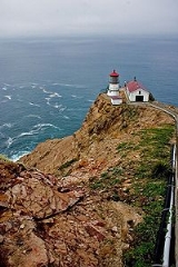
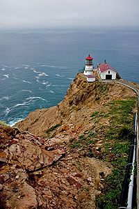
It can get very foggy and windy during certain parts of the year at the lighthouse, where visibility is so slim that one cannot even view the lighthouse from the top of the approximately 300 steps necessary to walk down to reach it.The lighthouse serves a great purpose in such a foggy area, as there is no beach to wash up on; it is on a rocky cliff. Day or night, the light may be the only thing visible to ships.
Recreation
The peninsula is a popular recreational destination for the nearby San Francisco Bay AreaSan Francisco Bay Area
The San Francisco Bay Area, commonly known as the Bay Area, is a populated region that surrounds the San Francisco and San Pablo estuaries in Northern California. The region encompasses metropolitan areas of San Francisco, Oakland, and San Jose, along with smaller urban and rural areas...
, especially for hiking
Hiking
Hiking is an outdoor activity which consists of walking in natural environments, often in mountainous or other scenic terrain. People often hike on hiking trails. It is such a popular activity that there are numerous hiking organizations worldwide. The health benefits of different types of hiking...
on its many trails and sea kayaking the shores of Tomales Bay and the coast. Point Reyes National Seashore offers some of the finest birdwatching in the United States, It is also one of the best places to watch Northern Elephant Seals in the winter months. More than 70000 acres (283.3 km²) of habitat harbor an incredible variety of bird life.
See also
- Point Reyes National SeashorePoint Reyes National SeashorePoint Reyes National Seashore is a park preserve located on the Point Reyes Peninsula in Marin County, California, USA. As a national seashore, it is maintained by the US National Park Service as a nationally important nature preserve within which existing agricultural uses are allowed to continue...
- Rancho Punta de los Reyes SobranteRancho Punta de los Reyes SobranteRancho Punta de los Reyes Sobrante was a Mexican land grant in present day West Marin County, California given by Governor Manuel Micheltorena in 1843 to Antonio Maria Osio. The name means "Leftover of Point Reyes Ranch"...