
.gif)
Downtown (Vancouver)
Encyclopedia
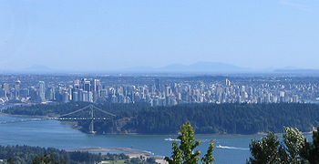
Downtown Vancouver is the term used to describe the southeastern portion of the peninsula
in the north-central part of Vancouver
proper. It is the business, commercial, cultural, financial, government, and entertainment centre of the city and the Metro Vancouver lower mainland
region.
to the north, Stanley Park
and the West End
to the west, False Creek
to the south, and the Downtown Eastside
to the east. Most sources include the full downtown peninsula (adding the West End neighbourhood and Stanley Park) as downtown Vancouver, but the City of Vancouver defines them as separate neighbourhoods.
Besides the readily identifiable office towers of the financial and central business districts, Downtown Vancouver also includes residential neighbourhoods in the form of high-rise apartment and condominiums, in Yaletown
and Coal Harbour
. Other downtown neighbourhoods include the Granville Mall
and Entertainment District
, Downtown's South, Gastown
, Japantown, and Chinatown.
municipalities and the Trans Canada Highway, the Burrard Street Bridge
, Cambie Street Bridge
, and Granville Street Bridge
provides access to the commercial and residential areas south of False Creek.
The historic Waterfront Station is a major transit hub for the downtown core. There are six rapid transit
subway stations in downtown Vancouver. The stations are found on three SkyTrain lines, Expo Line, Millennium Line
, and Canada Line
. The Expo and Millenium lines travel from the historic Waterfront Station at the foot of the central harbour, through the old Dunsmuir Tunnel
to the east. Canada Line travels from Waterfront Station and tunnels south under Granville Street
and Davie Street, linking downtown to central Richmond
and Vancouver International Airport
. SeaBus
is a passenger-only ferry that connects to the North Shore in 10–12 minutes. West Coast Express
commuter rail system that travels to the eastern suburbs and exurbs. Near Waterfront Station, terminals are available for float planes and helicopters.
Most north-south Vancouver bus routes serve the area, in addition to suburban routes from the North Shore, Burnaby, the Tri-Cities
, Richmond
, Delta
, and South Surrey
.
The bus rapid transit
line 98 B-Line
had eight stops in the downtown core, primarily along Seymour Street and Burrard Street
. This service was replaced on August 17, 2009 by SkyTrain's Canada Line.
There are two private passenger water taxi operators (False Creek Ferries
and The Aquabus
), providing service between several downtown neighbourhoods, False Creek
, and Granville Island
.
The city is planning to extend the downtown streetcar
from its current route of Granville Island
to the Main Street SkyTrain station, with future plans extending it to Chinatown and then to Stanley Park
.
's Vancouver Canucks
play at Rogers Arena (formerly GM Place), while the CFL
's BC Lions
use the neighbouring BC Place Stadium
. The Vancouver Whitecaps FC will also play at BC Place stadium beginning in October 2011, when completion of BC Place Stadium. SkyTrain Stadium-Chinatown station provides easy rapid transit access to the district.
Major renovations to BC Place Stadium are currently underway and are expected to be completed by the summer of 2011. Renovations include a new retractable roof and fan friendly amenities. As BC Place Stadium undergoes renovation, the BC Lions and Vancouver Whitecaps FC are using the temporary Empire Field
in east Vancouver for the 2010-2011 season.
Burrard Peninsula
The Burrard Peninsula is a peninsula in the Lower Mainland region of southwestern British Columbia, Canada, lying between Burrard Inlet to the north and the Fraser River to the south, and bounded by Georgia Strait on the west and the Pitt River on the east...
in the north-central part of Vancouver
Vancouver
Vancouver is a coastal seaport city on the mainland of British Columbia, Canada. It is the hub of Greater Vancouver, which, with over 2.3 million residents, is the third most populous metropolitan area in the country,...
proper. It is the business, commercial, cultural, financial, government, and entertainment centre of the city and the Metro Vancouver lower mainland
Lower Mainland
The Lower Mainland is a name commonly applied to the region surrounding and including Vancouver, British Columbia, Canada. As of 2007, 2,524,113 people live in the region; sixteen of the province's thirty most populous municipalities are located there.While the term Lower Mainland has been...
region.
Geography
The downtown area is generally considered to be bounded by Burrard InletBurrard Inlet
Burrard Inlet is a relatively shallow-sided coastal fjord in southwestern British Columbia, Canada. Formed during the last Ice Age, it separates the City of Vancouver and the rest of the low-lying Burrard Peninsula from the slopes of the North Shore Mountains, home to the communities of West...
to the north, Stanley Park
Stanley Park
Stanley Park is a 404.9 hectare urban park bordering downtown Vancouver, British Columbia, Canada. It was opened in 1888 by David Oppenheimer in the name of Lord Stanley of Preston, the Governor-General of Canada....
and the West End
West End, Vancouver
The West End of Vancouver, British Columbia, Canada is on the downtown peninsula neighbouring Stanley Park and the areas of Yaletown, Coal Harbour and the downtown financial and central business districts....
to the west, False Creek
False Creek
False Creek is a short inlet in the heart of Vancouver. It separates downtown from the rest of the city. It was named by George Henry Richards during his Hydrographic survey of 1856-63. Science World is located at its eastern end and the Burrard Street Bridge crosses its western end. False Creek is...
to the south, and the Downtown Eastside
Downtown Eastside
The Downtown Eastside is one of the oldest neighbourhoods in Vancouver, British Columbia, Canada and is known as "Canada's poorest postal code"....
to the east. Most sources include the full downtown peninsula (adding the West End neighbourhood and Stanley Park) as downtown Vancouver, but the City of Vancouver defines them as separate neighbourhoods.
Besides the readily identifiable office towers of the financial and central business districts, Downtown Vancouver also includes residential neighbourhoods in the form of high-rise apartment and condominiums, in Yaletown
Yaletown
Yaletown is an area of Downtown Vancouver approximately bordered by False Creek, Robson, and Homer Streets. Formerly a heavy industrial area dominated by warehouses and rail yards, since the Expo 86, it has been transformed into one of the most densely populated neighbourhoods in the city...
and Coal Harbour
Coal Harbour
Coal Harbour is the name for a section of Burrard Inlet lying between Vancouver, Canada's downtown peninsula and the Brockton Peninsula of Stanley Park...
. Other downtown neighbourhoods include the Granville Mall
Granville Mall (Vancouver)
Granville Mall is a transit mall and pedestrian mall in Vancouver, British Columbia, Canada. It comprises the section of Granville Street in Downtown Vancouver between Hastings and Smithe streets...
and Entertainment District
Granville Entertainment District
The Granville Entertainment District is an area in Downtown Vancouver known for its vast assortment of bars, danceclubs and nightlife. The entertainment district centred on a seven-block stretch of the Granville Mall and immediately surrounding streets....
, Downtown's South, Gastown
Gastown
Gastown is a national historic site in Vancouver, British Columbia, at the northeast end of Downtown adjacent to the Downtown Eastside. Its historical boundaries were the waterfront , Columbia Street, Hastings Street, and Cambie Street, which were the borders of the 1870 townsite survey, the proper...
, Japantown, and Chinatown.
Transportation
The presence of water on three sides limits access to downtown Vancouver. There are four major bridges: the Lions Gate Bridge, connecting to the North ShoreNorth Shore (Greater Vancouver)
"Vancouver's North Shore" is a term commonly used to refer to several areas adjacent to Vancouver, British Columbia, Canada:*the District of West Vancouver;*the City of North Vancouver;*the District of North Vancouver; and...
municipalities and the Trans Canada Highway, the Burrard Street Bridge
Burrard Street Bridge
The Burrard Bridge is a five-lane, Art Deco style, steel truss bridge constructed in 1930-1932 in Vancouver, British Columbia, Canada. The high, five part bridge on four piers spans False Creek, connecting downtown Vancouver with Kitsilano via connections to Burrard Street on both ends...
, Cambie Street Bridge
Cambie Street Bridge
The Cambie Bridge is a six-lane symmetric, precast, varying-depth-post tension-box girder bridge spanning False Creek in Vancouver, British Columbia. The current bridge opened in 1985, but is the third bridge at the same location...
, and Granville Street Bridge
Granville Street Bridge
The Granville Street Bridge is an eight lane bridge in Vancouver, British Columbia. It spans False Creek and is 27.4 metres above Granville Island. It is part of Highway 99.-History:...
provides access to the commercial and residential areas south of False Creek.
The historic Waterfront Station is a major transit hub for the downtown core. There are six rapid transit
Rapid transit
A rapid transit, underground, subway, elevated railway, metro or metropolitan railway system is an electric passenger railway in an urban area with a high capacity and frequency, and grade separation from other traffic. Rapid transit systems are typically located either in underground tunnels or on...
subway stations in downtown Vancouver. The stations are found on three SkyTrain lines, Expo Line, Millennium Line
Millennium Line
The Millennium Line is the second rapid transit line built in the SkyTrain light metro rapid transit system in Metro Vancouver, British Columbia, Canada. The line is owned and operated by TransLink. Millennium Line uses the colour yellow on route maps, wayfinding and station signage.-History:When...
, and Canada Line
Canada Line
Canada Line is a rapid transit line in the Metro Vancouver region of British Columbia, Canada. Opened in August 2009, it is the third line in TransLink's SkyTrain metro network, servicing Vancouver, Richmond, and the Vancouver International Airport...
. The Expo and Millenium lines travel from the historic Waterfront Station at the foot of the central harbour, through the old Dunsmuir Tunnel
Dunsmuir Tunnel
Dunsmuir Tunnel is a subway tunnel beneath Downtown Vancouver, British Columbia, Canada. Part of the Expo and Millennium SkyTrain lines, the tunnel is served by two stations: Burrard and Granville...
to the east. Canada Line travels from Waterfront Station and tunnels south under Granville Street
Granville Street
Granville Street is a major street in Vancouver, British Columbia, Canada, and part of Highway 99.-Location:Granville Street runs generally north-south through the centre of Vancouver, passing through several neighbourhoods and commercial areas, differing appreciably in their land value and the...
and Davie Street, linking downtown to central Richmond
Richmond, British Columbia
Richmond is a coastal city, incorporated in the Canadian province of British Columbia. Part of Metro Vancouver, its neighbouring communities are Vancouver and Burnaby to the north, New Westminster to the east, and Delta to the south, while the Strait of Georgia forms its western border...
and Vancouver International Airport
Vancouver International Airport
Vancouver International Airport is located on Sea Island in Richmond, British Columbia, Canada, about from Downtown Vancouver. In 2010 it was the second busiest airport in Canada by aircraft movements and passengers , behind Toronto Pearson International Airport, with non-stop flights daily to...
. SeaBus
SeaBus
The SeaBus is a passenger-only ferry service in Metro Vancouver, British Columbia, Canada. It crosses Burrard Inlet to connect the cities of Vancouver and North Vancouver. The SeaBus is owned and operated by the Coast Mountain Bus Company and is an important part of TransLink's integrated public...
is a passenger-only ferry that connects to the North Shore in 10–12 minutes. West Coast Express
West Coast Express
West Coast Express is the interregional commuter railway in British Columbia, Canada. Opened in 1995, it links Mission, Maple Ridge, Pitt Meadows, Port Coquitlam, Coquitlam, and Port Moody with Waterfront Station in Downtown Vancouver, where it interchanges with SkyTrain rapid transit, SeaBus and...
commuter rail system that travels to the eastern suburbs and exurbs. Near Waterfront Station, terminals are available for float planes and helicopters.
Most north-south Vancouver bus routes serve the area, in addition to suburban routes from the North Shore, Burnaby, the Tri-Cities
Tri-Cities (British Columbia)
The Tri-Cities is an informal term used to describe three adjacent suburban cities in the north-east sector of Metro Vancouver in British Columbia. Combined, these five communities have a 2008 population of 211,418 residents:-Other terms:...
, Richmond
Richmond, British Columbia
Richmond is a coastal city, incorporated in the Canadian province of British Columbia. Part of Metro Vancouver, its neighbouring communities are Vancouver and Burnaby to the north, New Westminster to the east, and Delta to the south, while the Strait of Georgia forms its western border...
, Delta
Delta, British Columbia
Delta is a district municipality in British Columbia, and forms part of Metro Vancouver. Located south of Richmond, it is bordered by the Fraser River to the north, the United States to the south and the city of Surrey to the east...
, and South Surrey
Surrey, British Columbia
Surrey is a city in the province of British Columbia, Canada. It is a member municipality of Metro Vancouver, the governing body of the Greater Vancouver Regional District...
.
The bus rapid transit
Bus rapid transit
Bus rapid transit is a term applied to a variety of public transportation systems using buses to provide faster, more efficient service than an ordinary bus line. Often this is achieved by making improvements to existing infrastructure, vehicles and scheduling...
line 98 B-Line
98 B-Line
The 98 B-Line was a bus rapid transit line in Metro Vancouver, British Columbia, Canada. It connected Richmond, British Columbia to Downtown Vancouver, with a connection to Vancouver International Airport. It travelled mainly along Granville Street in Vancouver and No. 3 Road in Richmond. It was...
had eight stops in the downtown core, primarily along Seymour Street and Burrard Street
Burrard Street
Burrard Street is a major thoroughfare in Vancouver, British Columbia, Canada. It is the central street of Downtown Vancouver and the Financial District. The street is named for Burrard Inlet, located at its northern terminus, which in turn is named for Sir Harry Burrard-Neale.The street starts at...
. This service was replaced on August 17, 2009 by SkyTrain's Canada Line.
There are two private passenger water taxi operators (False Creek Ferries
False Creek Ferries
False Creek Ferries, a division of Granville Island Ferries Ltd, is a privately owned and operated ferry service that operates on False Creek near downtown Vancouver, Canada...
and The Aquabus
The Aquabus
The Aquabus, also known as, Aquabus Ferries Ltd., is a privately owned and operated ferry service that provides commuter and sightseeing services to locations all along False Creek of central Vancouver, British Columbia, Canada...
), providing service between several downtown neighbourhoods, False Creek
False Creek
False Creek is a short inlet in the heart of Vancouver. It separates downtown from the rest of the city. It was named by George Henry Richards during his Hydrographic survey of 1856-63. Science World is located at its eastern end and the Burrard Street Bridge crosses its western end. False Creek is...
, and Granville Island
Granville Island
Granville Island is a peninsula and shopping district in Vancouver, British Columbia, Canada. It is located in False Creek directly across from Downtown Vancouver's peninsula, under the south end of the Granville Street Bridge....
.
The city is planning to extend the downtown streetcar
Vancouver Downtown Historic Railway
The Vancouver Downtown Historic Railway is a heritage streetcar line that operates between Granville Island and the Cambie Station in Vancouver, British Columbia, Canada. It operates only on weekends and holidays, usually from May to mid-October, and is aimed primarily at tourists...
from its current route of Granville Island
Granville Island
Granville Island is a peninsula and shopping district in Vancouver, British Columbia, Canada. It is located in False Creek directly across from Downtown Vancouver's peninsula, under the south end of the Granville Street Bridge....
to the Main Street SkyTrain station, with future plans extending it to Chinatown and then to Stanley Park
Stanley Park
Stanley Park is a 404.9 hectare urban park bordering downtown Vancouver, British Columbia, Canada. It was opened in 1888 by David Oppenheimer in the name of Lord Stanley of Preston, the Governor-General of Canada....
.
Professional sports
There are two major sporting facilities in the downtown core, Rogers Arena and BC Place Stadium. The NHLNational Hockey League
The National Hockey League is an unincorporated not-for-profit association which operates a major professional ice hockey league of 30 franchised member clubs, of which 7 are currently located in Canada and 23 in the United States...
's Vancouver Canucks
Vancouver Canucks
The Vancouver Canucks are a professional ice hockey team based in Vancouver, :British Columbia, Canada. They are members of the Northwest Division of the Western Conference of the National Hockey League . The Canucks play their home games at Rogers Arena, formerly known as General Motors Place,...
play at Rogers Arena (formerly GM Place), while the CFL
Canadian Football League
The Canadian Football League or CFL is a professional sports league located in Canada. The CFL is the highest level of competition in Canadian football, a form of gridiron football closely related to American football....
's BC Lions
BC Lions
The BC Lions are a professional Canadian football team competing in the West Division of Canadian Football League . Based in Vancouver, British Columbia, the Lions play their home games at BC Place Stadium in Downtown Vancouver, having previously played at Empire Stadium in East Vancouver from 1954...
use the neighbouring BC Place Stadium
BC Place Stadium
BC Place is a multi-purpose stadium located at the north side of False Creek, in Vancouver, British Columbia, Canada. It serves as the home field for the BC Lions of the Canadian Football League and the Vancouver Whitecaps FC of Major League Soccer . Originally opened on June 19, 1983 as the...
. The Vancouver Whitecaps FC will also play at BC Place stadium beginning in October 2011, when completion of BC Place Stadium. SkyTrain Stadium-Chinatown station provides easy rapid transit access to the district.
Major renovations to BC Place Stadium are currently underway and are expected to be completed by the summer of 2011. Renovations include a new retractable roof and fan friendly amenities. As BC Place Stadium undergoes renovation, the BC Lions and Vancouver Whitecaps FC are using the temporary Empire Field
Empire Field
Empire Field was a temporary outdoor football and soccer stadium built at the former location of Empire Stadium at Hastings Park in Vancouver, British Columbia. It served as the home of the BC Lions of the Canadian Football League from the summer of 2010 until the fall of 2011 when the installation...
in east Vancouver for the 2010-2011 season.