

West End, Vancouver
Encyclopedia
The West End of Vancouver
, British Columbia
, Canada
is on the downtown peninsula neighbouring Stanley Park
and the areas of Yaletown
, Coal Harbour
and the downtown financial and central business districts.
The definition of the "official neighbourhood" of the West End, according to the city, is the area west of Burrard Street, east of Denman Street, and south of West Georgia Street. Historically the term originated and remains used by Vancouverites to refer to everything from Burrard Street to Stanley Park, including the Stanley Park Neighbourhood west of Denman Street and the Coal Harbour Neighbourhood. Coal Harbour Neighbourhood is officially designated as west of Burrard and to the north of West Georgia, although the newly built areas between West Pender Street and the waterfront are expressly "Coal Harbour" and not considered part of the West End.
owing to the belief that the naive men paid too much for the remote land. The men had plans to establish a brickworks on the shore of Coal Harbour, and their land claim was originally staked with the hopeful intent of mining for porcelain clays, but the grade of clay was not fine enough for that use. When those plans failed (a lack of transportation being a key factor) they sold a good portion of the area, by then known as the Brickmaker's Claim, to Victoria investors who in turn tried to promote its development as New Liverpool. The only thing that happened with that scheme was a subdivision plan registered with the Land Titles office in New Westminster. Another name used for the property was the Brighouse Estate (Brighouse as a name came to refer to a particular part of Richmond
, where "Greenhorn" J. Morton also owned property). One of the partners, observant that brick was a valuable building commodity despite the abundance of timber in the region, moved the brick-clay operations to Sumas Mountain
, establishing the community of Clayburn
, now a neighbourhood of Abbotsford
.
 Later, with the arrival of the Canadian Pacific Railway
, with its terminus at nearby Coal Harbour
, the West End became Vancouver's first upscale neighbourhood, home to the richest railroad families. Many of these families lived along Georgia Street, known at that time as "Blue Blood Alley" for all the posh mansions built there. Later mansions (including the Davie mansion) were built in then remoter areas of the West End as the financial district's land values displaced the high-toned residences. This role was ultimately dropped with the increasing vogue for the upscale Shaughnessy neighbourhood, and as middle-class housing of various kinds began to fill out the West End. As the city grew, the West End became a transitory place for new arrivals from elsewhere in Canada, the United Kingdom, and later for immigrants from other countries, establishing a tradition of diversity. Following World War II, a significant German commercial community emerged along Robson Street
, giving birth to the nickname Robsonstrasse, a name still occasionally used in marketing despite the loss of its original meaning.
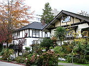
 The West End is bordered by downtown on the one side, Stanley Park on the other and by water on two. The West End is home to a mixed population, old and young, of Canadians, immigrants and international transient residents. Like other downtown neighbourhoods, the West End is very densely populated. It is adjacent to the downtown core business and financial districts, with traffic calmed streets punctuated by concrete islands, sidewalk barricades, and mini-parks and many residential heritage buildings including The Manhattan, The Beaconsfield, The Beverly and The Queen Charlotte.
The West End is also home to Vancouver's gay village
, called Davie Village
, centred primarily on Davie Street between Burrard and Bute, with a substantial gay population living throughout the West End.
Home to 42,120 people in 2001 http://www.city.vancouver.bc.ca/commsvcs/Census2001/WestEnd03.pdf 31.5% of residents are between 40 and 65, with 51% being between 20 and 40. The share of single-parent families in the West End is about 12%, compared to 17% for the City of Vancouver. Statistics also show that the West End is home to many children — the downtown peninsula now has more children than traditional family neighbourhoods such as West Point Grey or Kerrisdale
. The West End has two elementary school
s: Lord Roberts & Lord Roberts Annex. The neighbourhood is also served by one high school
, King George Secondary
.
. They also staged a successful "Shame the Johns" campaign to rid the West End of the prostitution that was then prevalent in the neighbourhood. Today, groups such as the West End Citizens Action Network, the West End Residents Association and West End Neighbours continue to be actively involved in keeping the West End liveable, albeit from different political perspectives.
. It was historically known as the Robsonstrasse, for the postwar period when it was a hub for immigrants from Germany
, and was home to owner operated boutiques, schnitzel houses and other bistro-style dining establishments until the 1980's when the transition to the current fashionable shopping and dining area stretching from Burrard Street to Jervis Street, began. Many restaurants and shops can also be found along Denman Street closer to Stanley Park
, and Davie Street between Burrard and Jervis streets.
Numerous parks and beaches can be found throughout the West End including Alexandra Park, Cardero Park, Nelson Park, Stanley Park
and Sunset Beach. These parks range in size from 0.22 hectares (Morton Park) to over 406 hectare (Stanley Park). A portion of the Stanley Park Seawall promenade runs along the waterfront from Burrard Bridge to Ceperly Park.
The area is also known for English Bay Beach, a large park on English Bay
which is thronged during the annual Celebration of Light
fireworks display each year mid-summer. St. Paul's Hospital, one of Vancouver's largest and oldest health facilities, sits at the neighbourhood's eastern edge on Burrard Street.
Community Centres in the West End include the Vancouver Aquatic Centre, West End Community Centre, Coal Harbour Community Centre and Barclay Manor. Depending on the centre, they offer swimming pools, gyms, fitness centres and an ice rink, as well as many meeting and all-purpose rooms for rent.
The West End is not to be confused with the West Side (which denotes the western half of the non-downtown part of Vancouver city to the south) or West Vancouver ("West Van"), a separate municipality. (Conversely, and to the confusion of some, "East Van," "the East End," and "the East Side" all denote East Vancouver
.)
Vancouver
Vancouver is a coastal seaport city on the mainland of British Columbia, Canada. It is the hub of Greater Vancouver, which, with over 2.3 million residents, is the third most populous metropolitan area in the country,...
, British Columbia
British Columbia
British Columbia is the westernmost of Canada's provinces and is known for its natural beauty, as reflected in its Latin motto, Splendor sine occasu . Its name was chosen by Queen Victoria in 1858...
, Canada
Canada
Canada is a North American country consisting of ten provinces and three territories. Located in the northern part of the continent, it extends from the Atlantic Ocean in the east to the Pacific Ocean in the west, and northward into the Arctic Ocean...
is on the downtown peninsula neighbouring Stanley Park
Stanley Park
Stanley Park is a 404.9 hectare urban park bordering downtown Vancouver, British Columbia, Canada. It was opened in 1888 by David Oppenheimer in the name of Lord Stanley of Preston, the Governor-General of Canada....
and the areas of Yaletown
Yaletown
Yaletown is an area of Downtown Vancouver approximately bordered by False Creek, Robson, and Homer Streets. Formerly a heavy industrial area dominated by warehouses and rail yards, since the Expo 86, it has been transformed into one of the most densely populated neighbourhoods in the city...
, Coal Harbour
Coal Harbour
Coal Harbour is the name for a section of Burrard Inlet lying between Vancouver, Canada's downtown peninsula and the Brockton Peninsula of Stanley Park...
and the downtown financial and central business districts.
The definition of the "official neighbourhood" of the West End, according to the city, is the area west of Burrard Street, east of Denman Street, and south of West Georgia Street. Historically the term originated and remains used by Vancouverites to refer to everything from Burrard Street to Stanley Park, including the Stanley Park Neighbourhood west of Denman Street and the Coal Harbour Neighbourhood. Coal Harbour Neighbourhood is officially designated as west of Burrard and to the north of West Georgia, although the newly built areas between West Pender Street and the waterfront are expressly "Coal Harbour" and not considered part of the West End.
History
Like all of Vancouver, the West End was originally a forested wilderness. The area was purchased in 1862 by John Morton, Samuel Brighouse, and William Hailstone, three men known as the "Three Greenhorn Englishmen," or just the "Three Greenhorns,"The Three Greenhorns
The Three Greenhorns were three Englishmen, Samuel Brighouse, William Hailstone and John Morton, who were the first white settlers in the area known today as Vancouver's West End...
owing to the belief that the naive men paid too much for the remote land. The men had plans to establish a brickworks on the shore of Coal Harbour, and their land claim was originally staked with the hopeful intent of mining for porcelain clays, but the grade of clay was not fine enough for that use. When those plans failed (a lack of transportation being a key factor) they sold a good portion of the area, by then known as the Brickmaker's Claim, to Victoria investors who in turn tried to promote its development as New Liverpool. The only thing that happened with that scheme was a subdivision plan registered with the Land Titles office in New Westminster. Another name used for the property was the Brighouse Estate (Brighouse as a name came to refer to a particular part of Richmond
Richmond, British Columbia
Richmond is a coastal city, incorporated in the Canadian province of British Columbia. Part of Metro Vancouver, its neighbouring communities are Vancouver and Burnaby to the north, New Westminster to the east, and Delta to the south, while the Strait of Georgia forms its western border...
, where "Greenhorn" J. Morton also owned property). One of the partners, observant that brick was a valuable building commodity despite the abundance of timber in the region, moved the brick-clay operations to Sumas Mountain
Sumas Mountain (British Columbia)
Sumas Mountain, aka referred to as Canadian Sumas to distinguish it from an identically-named mountain just south in Washington state, is a relatively large mountain rising from the floodplain of the Fraser River in the Lower Mainland of southwestern British Columbia, Canada...
, establishing the community of Clayburn
Clayburn, British Columbia
Clayburn is a small historic village now located with the City of Abbotsford, in the Central Fraser Valley of British Columbia. Largely surrounded by farmland and green fields, on the northern slopes of Sumas Mountain's eastern ridge, the historic centre is situated immediately north and east of...
, now a neighbourhood of Abbotsford
Abbotsford, British Columbia
Abbotsford is a Canadian city located in the Lower Mainland of British Columbia, adjacent to Greater Vancouver. It is the fifth largest municipality in British Columbia, home to 123,864 people . Its Census Metropolitan Area, which includes the District of Mission, is the 23rd largest in Canada,...
.
Canadian Pacific Railway
The Canadian Pacific Railway , formerly also known as CP Rail between 1968 and 1996, is a historic Canadian Class I railway founded in 1881 and now operated by Canadian Pacific Railway Limited, which began operations as legal owner in a corporate restructuring in 2001...
, with its terminus at nearby Coal Harbour
Coal Harbour
Coal Harbour is the name for a section of Burrard Inlet lying between Vancouver, Canada's downtown peninsula and the Brockton Peninsula of Stanley Park...
, the West End became Vancouver's first upscale neighbourhood, home to the richest railroad families. Many of these families lived along Georgia Street, known at that time as "Blue Blood Alley" for all the posh mansions built there. Later mansions (including the Davie mansion) were built in then remoter areas of the West End as the financial district's land values displaced the high-toned residences. This role was ultimately dropped with the increasing vogue for the upscale Shaughnessy neighbourhood, and as middle-class housing of various kinds began to fill out the West End. As the city grew, the West End became a transitory place for new arrivals from elsewhere in Canada, the United Kingdom, and later for immigrants from other countries, establishing a tradition of diversity. Following World War II, a significant German commercial community emerged along Robson Street
Robson Street
Robson Street is a major southeast-northwest thoroughfare in downtown and West End of Vancouver, British Columbia, Canada. Its core commercial blocks from Burrard Street to Jervis are also known as Robsonstrasse. Its name honours John Robson, a major figure in British Columbia's entry into the...
, giving birth to the nickname Robsonstrasse, a name still occasionally used in marketing despite the loss of its original meaning.
Demographics
The West End is also home to Vancouver's gay village
Gay village
A gay village is an urban geographic location with generally recognized boundaries where a large number of lesbian, gay, bisexual, and transgender people live or frequent...
, called Davie Village
Davie Village
Davie Village is a neighbourhood in the West End of Vancouver, British Columbia, Canada. It is the home of the city's gay subculture, and, as such, is often considered a gay village or "gaybourhood". It is centred on Davie Street and roughly includes the area between Burrard and Jervis streets...
, centred primarily on Davie Street between Burrard and Bute, with a substantial gay population living throughout the West End.
Home to 42,120 people in 2001 http://www.city.vancouver.bc.ca/commsvcs/Census2001/WestEnd03.pdf 31.5% of residents are between 40 and 65, with 51% being between 20 and 40. The share of single-parent families in the West End is about 12%, compared to 17% for the City of Vancouver. Statistics also show that the West End is home to many children — the downtown peninsula now has more children than traditional family neighbourhoods such as West Point Grey or Kerrisdale
Kerrisdale
Kerrisdale is a neighbourhood in the city of Vancouver, British Columbia, Canada.Kerrisdale is a neighbourhood featuring a mix of newer houses and older bungalows as well as various low and mid-rise rental and condo apartment buildings in its northern section. The neighbourhood is an ethnic mix of...
. The West End has two elementary school
Elementary school
An elementary school or primary school is an institution where children receive the first stage of compulsory education known as elementary or primary education. Elementary school is the preferred term in some countries, particularly those in North America, where the terms grade school and grammar...
s: Lord Roberts & Lord Roberts Annex. The neighbourhood is also served by one high school
High school
High school is a term used in parts of the English speaking world to describe institutions which provide all or part of secondary education. The term is often incorporated into the name of such institutions....
, King George Secondary
King George Secondary School
King George Secondary School is a public secondary school located in Vancouver, British Columbia, Canada.The school is located in the West End, with two elementary schools feeding in...
.
Social issues
West End residents have been very active in shaping their neighbourhood and maintaining its liveability. In the 1970s, residents banded together to calm traffic that was using the neighbourhood as a shortcut between downtown Vancouver and the suburbs of the North Shore, across the Lions' Gate BridgeLions' Gate Bridge
The Lions Gate Bridge, officially known as the First Narrows Bridge, is a suspension bridge that crosses the first narrows of Burrard Inlet and connects the City of Vancouver, British Columbia, to the North Shore municipalities of the District of North Vancouver, the City of North Vancouver, and...
. They also staged a successful "Shame the Johns" campaign to rid the West End of the prostitution that was then prevalent in the neighbourhood. Today, groups such as the West End Citizens Action Network, the West End Residents Association and West End Neighbours continue to be actively involved in keeping the West End liveable, albeit from different political perspectives.
Amenities
The West End is particularly famous among visitors for Robson StreetRobson Street
Robson Street is a major southeast-northwest thoroughfare in downtown and West End of Vancouver, British Columbia, Canada. Its core commercial blocks from Burrard Street to Jervis are also known as Robsonstrasse. Its name honours John Robson, a major figure in British Columbia's entry into the...
. It was historically known as the Robsonstrasse, for the postwar period when it was a hub for immigrants from Germany
Germany
Germany , officially the Federal Republic of Germany , is a federal parliamentary republic in Europe. The country consists of 16 states while the capital and largest city is Berlin. Germany covers an area of 357,021 km2 and has a largely temperate seasonal climate...
, and was home to owner operated boutiques, schnitzel houses and other bistro-style dining establishments until the 1980's when the transition to the current fashionable shopping and dining area stretching from Burrard Street to Jervis Street, began. Many restaurants and shops can also be found along Denman Street closer to Stanley Park
Stanley Park
Stanley Park is a 404.9 hectare urban park bordering downtown Vancouver, British Columbia, Canada. It was opened in 1888 by David Oppenheimer in the name of Lord Stanley of Preston, the Governor-General of Canada....
, and Davie Street between Burrard and Jervis streets.
Numerous parks and beaches can be found throughout the West End including Alexandra Park, Cardero Park, Nelson Park, Stanley Park
Stanley Park
Stanley Park is a 404.9 hectare urban park bordering downtown Vancouver, British Columbia, Canada. It was opened in 1888 by David Oppenheimer in the name of Lord Stanley of Preston, the Governor-General of Canada....
and Sunset Beach. These parks range in size from 0.22 hectares (Morton Park) to over 406 hectare (Stanley Park). A portion of the Stanley Park Seawall promenade runs along the waterfront from Burrard Bridge to Ceperly Park.
The area is also known for English Bay Beach, a large park on English Bay
English Bay, Vancouver
English Bay is located in Vancouver, British Columbia, Canada, west of the downtown peninsula, which separates the bay from Burrard Inlet connecting to the northwest, and False Creek to the southeast. English Bay Beach, near the city's West End residential neighbourhood, is the most popular...
which is thronged during the annual Celebration of Light
Celebration of Light
The Celebration of Light is an annual musical fireworks competition in Vancouver, British Columbia, Canada. The first "Symphony of Fire" was held from July 25 to August 5 of 1990. The celebration is one of Vancouver's largest and most well known festivals...
fireworks display each year mid-summer. St. Paul's Hospital, one of Vancouver's largest and oldest health facilities, sits at the neighbourhood's eastern edge on Burrard Street.
Community Centres in the West End include the Vancouver Aquatic Centre, West End Community Centre, Coal Harbour Community Centre and Barclay Manor. Depending on the centre, they offer swimming pools, gyms, fitness centres and an ice rink, as well as many meeting and all-purpose rooms for rent.
The West End is not to be confused with the West Side (which denotes the western half of the non-downtown part of Vancouver city to the south) or West Vancouver ("West Van"), a separate municipality. (Conversely, and to the confusion of some, "East Van," "the East End," and "the East Side" all denote East Vancouver
East Vancouver
East Vancouver is a region within the City of Vancouver, British Columbia, Canada. Geographically, East Vancouver is bordered to the north by Burrard Inlet, to the south by the Fraser River, and to the east by the city of Burnaby...
.)