

98 B-Line
Encyclopedia
The 98 B-Line was a bus rapid transit
line in Metro Vancouver, British Columbia
, Canada
. It connected Richmond, British Columbia
to Downtown Vancouver
, with a connection to Vancouver International Airport
. It travelled mainly along Granville Street
in Vancouver and No. 3 Road in Richmond. It was operated by Coast Mountain Bus Company
and was funded by TransLink. The route was 16 kilometres (9.9 mi) long. The line carried over 18,000 passengers daily (http://www.apta.com/research/info/briefings/documents/mills.pdf, PDF file). It was discontinued on September 7, 2009, two and a half weeks after the opening of the Canada Line
, which replaced it.
The 98 B-Line was an experiment in rapid transit using global positioning system (GPS) technology, automated stop announcements, specialized bus stop displays that showed the amount of time until the next bus arrives, and special traffic light signals that sustained green lights long enough for buses to pass through. All these were developed by Siemens
. In 2007, TransLink admitted the bus stop displays were frequently broken or inaccurate and that shutting them down was a possibility; however, they remained active until the termination of the route. The GPS system which sustains green lights continues to be operational.(http://www.cbc.ca/canada/british-columbia/story/2007/03/08/bc-signs.html)
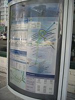
The 98 B-Line had nine stops in Richmond (including the transfer point to the airport) and fourteen stops in Vancouver (including seven stops downtown). Waiting times were approximately five to seven minutes per bus during peak hours and ten minutes per bus during mid-afternoons. In the evening and at night, the waiting time was around fifteen minutes per bus, and in the early morning the waiting time was around 20 to 30 minutes. Total travel time from end to end on the route was approximately 42 minutes, but could increase to one hour during peak hours due to traffic.
In Richmond, the 98 B-Line followed a dedicated bus lane separated from mainstream traffic on No. 3 Road, between the Lansdowne and Sea Island Way stops. On February 13, 2006, the 98 B-Line's bus lane in Richmond was closed as utility crews prepared for the construction of the Canada Line along No. 3 Road. Between February 2006 until its discontinuation in September 2009, the 98 B-Line travelled with regular traffic.
The route was modelled after the successful 99 B-Line
, which operates between University of British Columbia
and Commercial-Broadway SkyTrain
station. Like its older counterpart, larger articulated buses were normally used for this route, each with a 120-passenger capacity. These buses were built by New Flyer Industries
of Winnipeg
, Manitoba
.
Although the idea of a rapid bus line from Richmond to Vancouver had been discussed for decades, it was first proposed by BC Transit
in 1994. In 1995, Vancouver city council approved a southbound high-occupancy vehicle lane
for the evening peak hours in the Marpole
neighbourhood in preparation for an express bus service. In 1997, the idea of a rapid transit line was re-introduced with the objective of providing the express service at regular fares. A study was done and it was determined that the best route for the line would be through Granville Street in Vancouver .
The project cost about $52 million CAD
to build ; this includes the price of new vehicles, the construction of a dedicated bus lane in Richmond, installing new bus shelters, automated on-board announcements and similar technology, transit priority systems for traffic lights and a share of the new Richmond bus depot (as the old Vancouver Oakridge depot could not accommodate the longer 60 feet (18.3 m) articulated buses used on the route ). The line was officially opened in August 2001.
With the introduction of the B-Line, almost all other local bus services traveling between Richmond and Vancouver were eliminated, resulting in most commuters having to transfer from a local service to the B-Line. As a result of the added transfer and quicker travel times of the B-Line that did not materialize, commute times for passengers increased even though a commute time savings of several minutes had been promised. Within a few years, rush hours routes were created which effectively restored direct rush hour service from most urban areas of Richmond to Vancouver.
The B-line was one of the most used routes in the TransLink system. Around 2002 to 2003, plans to replace the 98 B-Line with a light rail line were being brought up. This new line's working name was the "RAV Line" (with RAV standing for Richmond-Airport-Vancouver). It generated much controversy, mainly due to its estimated cost of $1.72 billion CAD. The project was also threatened by political interference from Richmond city council, which had insisted that the line being operated in the city at grade principally because they favored the aesthetic attributes of an at grade line over an above grade line; faced with the majority of public favoring an above grade line and the consideration that an at grade line would increase operating costs and significantly increase trip times, Richmond council backed down. The project was voted down by the TransLink board twice because of political infighting because the board members representing the northeast areas of Greater Vancouver wanted a line built to Coquitlam. The "RAV Line" project was saved after the board agreed to build both lines by 2010.. While not part of the 2010 Winter Olympics
in Vancouver, the Canada Line
was completed in August 2009, and has now replaced the 98 B-Line.
As February 2008, 98 B-Line route passengers with valid proof of payment were permitted to board using any of the three doors at any stop. To facilitate this, the bus driver controlled the operation of all three doors at each of the stops. Passengers paying cash or validating FareSavers had to board through the front door.
The 98 B-Line was discontinued on September 7, 2009, two and a half weeks after the Canada Line
opened. After this date, the #10 Hastings/Downtown/Granville bus began running more frequently along Granville street to compensate.
Bus rapid transit
Bus rapid transit is a term applied to a variety of public transportation systems using buses to provide faster, more efficient service than an ordinary bus line. Often this is achieved by making improvements to existing infrastructure, vehicles and scheduling...
line in Metro Vancouver, British Columbia
British Columbia
British Columbia is the westernmost of Canada's provinces and is known for its natural beauty, as reflected in its Latin motto, Splendor sine occasu . Its name was chosen by Queen Victoria in 1858...
, Canada
Canada
Canada is a North American country consisting of ten provinces and three territories. Located in the northern part of the continent, it extends from the Atlantic Ocean in the east to the Pacific Ocean in the west, and northward into the Arctic Ocean...
. It connected Richmond, British Columbia
Richmond, British Columbia
Richmond is a coastal city, incorporated in the Canadian province of British Columbia. Part of Metro Vancouver, its neighbouring communities are Vancouver and Burnaby to the north, New Westminster to the east, and Delta to the south, while the Strait of Georgia forms its western border...
to Downtown Vancouver
Vancouver
Vancouver is a coastal seaport city on the mainland of British Columbia, Canada. It is the hub of Greater Vancouver, which, with over 2.3 million residents, is the third most populous metropolitan area in the country,...
, with a connection to Vancouver International Airport
Vancouver International Airport
Vancouver International Airport is located on Sea Island in Richmond, British Columbia, Canada, about from Downtown Vancouver. In 2010 it was the second busiest airport in Canada by aircraft movements and passengers , behind Toronto Pearson International Airport, with non-stop flights daily to...
. It travelled mainly along Granville Street
Granville Street
Granville Street is a major street in Vancouver, British Columbia, Canada, and part of Highway 99.-Location:Granville Street runs generally north-south through the centre of Vancouver, passing through several neighbourhoods and commercial areas, differing appreciably in their land value and the...
in Vancouver and No. 3 Road in Richmond. It was operated by Coast Mountain Bus Company
Coast Mountain Bus Company
Coast Mountain Bus Company is the contract operator for bus transit services in Metro Vancouver and is a wholly owned subsidiary of the South Coast British Columbia Transportation Authority known locally as TransLink, the entity responsible for transit...
and was funded by TransLink. The route was 16 kilometres (9.9 mi) long. The line carried over 18,000 passengers daily (http://www.apta.com/research/info/briefings/documents/mills.pdf, PDF file). It was discontinued on September 7, 2009, two and a half weeks after the opening of the Canada Line
Canada Line
Canada Line is a rapid transit line in the Metro Vancouver region of British Columbia, Canada. Opened in August 2009, it is the third line in TransLink's SkyTrain metro network, servicing Vancouver, Richmond, and the Vancouver International Airport...
, which replaced it.
The 98 B-Line was an experiment in rapid transit using global positioning system (GPS) technology, automated stop announcements, specialized bus stop displays that showed the amount of time until the next bus arrives, and special traffic light signals that sustained green lights long enough for buses to pass through. All these were developed by Siemens
Siemens AG
Siemens AG is a German multinational conglomerate company headquartered in Munich, Germany. It is the largest Europe-based electronics and electrical engineering company....
. In 2007, TransLink admitted the bus stop displays were frequently broken or inaccurate and that shutting them down was a possibility; however, they remained active until the termination of the route. The GPS system which sustains green lights continues to be operational.(http://www.cbc.ca/canada/british-columbia/story/2007/03/08/bc-signs.html)
The 98 B-Line had nine stops in Richmond (including the transfer point to the airport) and fourteen stops in Vancouver (including seven stops downtown). Waiting times were approximately five to seven minutes per bus during peak hours and ten minutes per bus during mid-afternoons. In the evening and at night, the waiting time was around fifteen minutes per bus, and in the early morning the waiting time was around 20 to 30 minutes. Total travel time from end to end on the route was approximately 42 minutes, but could increase to one hour during peak hours due to traffic.
In Richmond, the 98 B-Line followed a dedicated bus lane separated from mainstream traffic on No. 3 Road, between the Lansdowne and Sea Island Way stops. On February 13, 2006, the 98 B-Line's bus lane in Richmond was closed as utility crews prepared for the construction of the Canada Line along No. 3 Road. Between February 2006 until its discontinuation in September 2009, the 98 B-Line travelled with regular traffic.
The route was modelled after the successful 99 B-Line
99 B-Line
The 99 B-Line is a bus rapid transit line in Metro Vancouver, British Columbia, Canada. It travels along Broadway, a major east-west thoroughfare, and connects the University of British Columbia to Commercial–Broadway Station on the SkyTrain system...
, which operates between University of British Columbia
University of British Columbia
The University of British Columbia is a public research university. UBC’s two main campuses are situated in Vancouver and in Kelowna in the Okanagan Valley...
and Commercial-Broadway SkyTrain
SkyTrain (Vancouver)
SkyTrain is a light rapid transit system in Metro Vancouver, British Columbia, Canada. SkyTrain has of track and uses fully automated trains on grade-separated tracks, running mostly on elevated guideways, which helps SkyTrain to hold consistently high on-time reliability...
station. Like its older counterpart, larger articulated buses were normally used for this route, each with a 120-passenger capacity. These buses were built by New Flyer Industries
New Flyer Industries
New Flyer Industries Inc. is a bus manufacturer in North America, headquartered in Winnipeg, Manitoba, Canada. It also has factories in Crookston and St. Cloud, Minnesota, USA.-History:...
of Winnipeg
Winnipeg
Winnipeg is the capital and largest city of Manitoba, Canada, and is the primary municipality of the Winnipeg Capital Region, with more than half of Manitoba's population. It is located near the longitudinal centre of North America, at the confluence of the Red and Assiniboine Rivers .The name...
, Manitoba
Manitoba
Manitoba is a Canadian prairie province with an area of . The province has over 110,000 lakes and has a largely continental climate because of its flat topography. Agriculture, mostly concentrated in the fertile southern and western parts of the province, is vital to the province's economy; other...
.
History
Prior to the introduction of the 98 B-Line, most bus routes in Richmond traveled into Downtown Vancouver during rush hours. These routes stopped at all stops along their routes in Richmond, then would operate along Granville Street in Vancouver as express services.Although the idea of a rapid bus line from Richmond to Vancouver had been discussed for decades, it was first proposed by BC Transit
BC Transit
BC Transit is a provincial crown agency responsible for coordinating the delivery of public transportation within British Columbia, Canada, outside of Greater Vancouver...
in 1994. In 1995, Vancouver city council approved a southbound high-occupancy vehicle lane
High-occupancy vehicle lane
In transportation engineering and transportation planning, a high-occupancy vehicle lane is a lane reserved for vehicles with a driver and one or more passengers...
for the evening peak hours in the Marpole
Marpole
Marpole is a mostly residential neighbourhood of 22,400 located on the southern edge of the city of Vancouver, British Columbia, immediately northeast of Vancouver International Airport. It is approximately bordered by Angus Drive to the west, 57th Avenue to the north, Main Street to the east and...
neighbourhood in preparation for an express bus service. In 1997, the idea of a rapid transit line was re-introduced with the objective of providing the express service at regular fares. A study was done and it was determined that the best route for the line would be through Granville Street in Vancouver .
The project cost about $52 million CAD
Canadian dollar
The Canadian dollar is the currency of Canada. As of 2007, the Canadian dollar is the 7th most traded currency in the world. It is abbreviated with the dollar sign $, or C$ to distinguish it from other dollar-denominated currencies...
to build ; this includes the price of new vehicles, the construction of a dedicated bus lane in Richmond, installing new bus shelters, automated on-board announcements and similar technology, transit priority systems for traffic lights and a share of the new Richmond bus depot (as the old Vancouver Oakridge depot could not accommodate the longer 60 feet (18.3 m) articulated buses used on the route ). The line was officially opened in August 2001.
With the introduction of the B-Line, almost all other local bus services traveling between Richmond and Vancouver were eliminated, resulting in most commuters having to transfer from a local service to the B-Line. As a result of the added transfer and quicker travel times of the B-Line that did not materialize, commute times for passengers increased even though a commute time savings of several minutes had been promised. Within a few years, rush hours routes were created which effectively restored direct rush hour service from most urban areas of Richmond to Vancouver.
The B-line was one of the most used routes in the TransLink system. Around 2002 to 2003, plans to replace the 98 B-Line with a light rail line were being brought up. This new line's working name was the "RAV Line" (with RAV standing for Richmond-Airport-Vancouver). It generated much controversy, mainly due to its estimated cost of $1.72 billion CAD. The project was also threatened by political interference from Richmond city council, which had insisted that the line being operated in the city at grade principally because they favored the aesthetic attributes of an at grade line over an above grade line; faced with the majority of public favoring an above grade line and the consideration that an at grade line would increase operating costs and significantly increase trip times, Richmond council backed down. The project was voted down by the TransLink board twice because of political infighting because the board members representing the northeast areas of Greater Vancouver wanted a line built to Coquitlam. The "RAV Line" project was saved after the board agreed to build both lines by 2010.. While not part of the 2010 Winter Olympics
2010 Winter Olympics
The 2010 Winter Olympics, officially the XXI Olympic Winter Games or the 21st Winter Olympics, were a major international multi-sport event held from February 12–28, 2010, in Vancouver, British Columbia, Canada, with some events held in the suburbs of Richmond, West Vancouver and the University...
in Vancouver, the Canada Line
Canada Line
Canada Line is a rapid transit line in the Metro Vancouver region of British Columbia, Canada. Opened in August 2009, it is the third line in TransLink's SkyTrain metro network, servicing Vancouver, Richmond, and the Vancouver International Airport...
was completed in August 2009, and has now replaced the 98 B-Line.
As February 2008, 98 B-Line route passengers with valid proof of payment were permitted to board using any of the three doors at any stop. To facilitate this, the bus driver controlled the operation of all three doors at each of the stops. Passengers paying cash or validating FareSavers had to board through the front door.
The 98 B-Line was discontinued on September 7, 2009, two and a half weeks after the Canada Line
Canada Line
Canada Line is a rapid transit line in the Metro Vancouver region of British Columbia, Canada. Opened in August 2009, it is the third line in TransLink's SkyTrain metro network, servicing Vancouver, Richmond, and the Vancouver International Airport...
opened. After this date, the #10 Hastings/Downtown/Granville bus began running more frequently along Granville street to compensate.
Downtown Vancouver
- Seymour & Davie - Served the upscale YaletownYaletownYaletown is an area of Downtown Vancouver approximately bordered by False Creek, Robson, and Homer Streets. Formerly a heavy industrial area dominated by warehouses and rail yards, since the Expo 86, it has been transformed into one of the most densely populated neighbourhoods in the city...
neighbourhood. (Note: The bus's destination sign changes to "98 B-Line: Richmond Centre" at this point.) - Seymour & Smithe - Served the nightclub area on Granville StreetGranville StreetGranville Street is a major street in Vancouver, British Columbia, Canada, and part of Highway 99.-Location:Granville Street runs generally north-south through the centre of Vancouver, passing through several neighbourhoods and commercial areas, differing appreciably in their land value and the...
, a block to the west. It is also the stop for street youth hostels in the area and the Orpheum Theatre. - Granville Station - Transfer point to the SkyTrain system and suburban routes to North VancouverNorth Vancouver, British Columbia (city)The City of North Vancouver is a waterfront municipality on the north shore of Burrard Inlet, directly across from Vancouver, British Columbia. It is the smallest of the three North Shore municipalities, and the most urbanized as well...
and West Vancouver. Also served the major commercial district as well as the Vancouver Public LibraryVancouver Public LibraryThe Vancouver Public Library is the third largest public library system in Canada, with more than 2.5 million items in its collections, 22 branches, approximately 375,000 cardholders, and nearly nine million item borrowings annually...
, which is several blocks to the east. - Waterfront StationWaterfront Station (Vancouver)Waterfront Station is a major intermodal public transportation facility and the main transit terminus in Downtown Vancouver, British Columbia, Canada.-Location:...
- Transfer point to the SkyTrain terminus for both the Expo and MillenniumMillennium LineThe Millennium Line is the second rapid transit line built in the SkyTrain light metro rapid transit system in Metro Vancouver, British Columbia, Canada. The line is owned and operated by TransLink. Millennium Line uses the colour yellow on route maps, wayfinding and station signage.-History:When...
Lines, as well as the SeaBusSeaBusThe SeaBus is a passenger-only ferry service in Metro Vancouver, British Columbia, Canada. It crosses Burrard Inlet to connect the cities of Vancouver and North Vancouver. The SeaBus is owned and operated by the Coast Mountain Bus Company and is an important part of TransLink's integrated public...
to Lonsdale QuayLonsdale QuayLonsdale Quay is a major transit hub for Vancouver's North Shore municipalities, as well as a public market and tourist destination. Located at the foot of Lonsdale Avenue in the City of North Vancouver, British Columbia, Canada, it is the northern terminal for the SeaBus passenger ferry...
in North VancouverNorth Vancouver, British Columbia (city)The City of North Vancouver is a waterfront municipality on the north shore of Burrard Inlet, directly across from Vancouver, British Columbia. It is the smallest of the three North Shore municipalities, and the most urbanized as well...
. It is also the western terminus of the West Coast ExpressWest Coast ExpressWest Coast Express is the interregional commuter railway in British Columbia, Canada. Opened in 1995, it links Mission, Maple Ridge, Pitt Meadows, Port Coquitlam, Coquitlam, and Port Moody with Waterfront Station in Downtown Vancouver, where it interchanges with SkyTrain rapid transit, SeaBus and...
. - Burrard StationBurrard StationBurrard Station is a SkyTrain station in Vancouver, British Columbia, Canada, served by the Expo and Millennium Lines. The station is located in the Dunsmuir Tunnel located beneath Downtown Vancouver, and opened in 1985.-Location:...
- This is the Vancouver terminus for the 98 B-Line, though it does not make a layover. Located in the middle of the financial district. Transfer point to the SkyTrain system as well as to suburban routes to Burnaby, North Vancouver, SurreySurrey, British ColumbiaSurrey is a city in the province of British Columbia, Canada. It is a member municipality of Metro Vancouver, the governing body of the Greater Vancouver Regional District...
, DeltaDelta, British ColumbiaDelta is a district municipality in British Columbia, and forms part of Metro Vancouver. Located south of Richmond, it is bordered by the Fraser River to the north, the United States to the south and the city of Surrey to the east...
, White RockWhite Rock, British ColumbiaWhite Rock is a city in British Columbia, Canada, that lies within the Metro Vancouver regional district. It borders Semiahmoo Bay and is surrounded on three sides by the City of Surrey, British Columbia. To the south lies the Semiahmoo First Nation, which is within the city limits of Surrey...
, Coquitlam and Port Moody. - Burrard & Robson - Served the Robson StreetRobson StreetRobson Street is a major southeast-northwest thoroughfare in downtown and West End of Vancouver, British Columbia, Canada. Its core commercial blocks from Burrard Street to Jervis are also known as Robsonstrasse. Its name honours John Robson, a major figure in British Columbia's entry into the...
shopping district. - Nelson & Hornby - Formerly known as Nelson & Howe, before the stop was moved. Stopped in front of One Wall CentreOne Wall CentreOne Wall Centre, also known as the Sheraton Wall Centre - North Tower, is currently the second-tallest completed building in Vancouver, British Columbia, Canada. The skyscraper is located at a high point on the downtown peninsula of Vancouver and its address is 1088 Burrard Street.One Wall Centre...
. Also served the provincial law courts. - Howe & Davie - Served the hospitality district near False CreekFalse CreekFalse Creek is a short inlet in the heart of Vancouver. It separates downtown from the rest of the city. It was named by George Henry Richards during his Hydrographic survey of 1856-63. Science World is located at its eastern end and the Burrard Street Bridge crosses its western end. False Creek is...
. Also a transfer point to buses and community shuttles to Davie VillageDavie VillageDavie Village is a neighbourhood in the West End of Vancouver, British Columbia, Canada. It is the home of the city's gay subculture, and, as such, is often considered a gay village or "gaybourhood". It is centred on Davie Street and roughly includes the area between Burrard and Jervis streets...
.
Vancouver
- 5th Avenue - Served the southern False CreekFalse CreekFalse Creek is a short inlet in the heart of Vancouver. It separates downtown from the rest of the city. It was named by George Henry Richards during his Hydrographic survey of 1856-63. Science World is located at its eastern end and the Burrard Street Bridge crosses its western end. False Creek is...
area as well as Granville IslandGranville IslandGranville Island is a peninsula and shopping district in Vancouver, British Columbia, Canada. It is located in False Creek directly across from Downtown Vancouver's peninsula, under the south end of the Granville Street Bridge....
. - BroadwayBroadway (Vancouver)Broadway is a major east-west thoroughfare in the city of Vancouver, British Columbia, Canada. In Vancouver's numbered avenue grid system, it runs in place of a 9th Avenue, between 8th and 10th. The street has four lanes for most of its course...
- Transfer point to the 99 B-Line99 B-LineThe 99 B-Line is a bus rapid transit line in Metro Vancouver, British Columbia, Canada. It travels along Broadway, a major east-west thoroughfare, and connects the University of British Columbia to Commercial–Broadway Station on the SkyTrain system...
as well as many trolley routes. It is a short distance away from Vancouver General HospitalVancouver General HospitalVancouver General Hospital is a medical facility located in Vancouver, British Columbia. It is the largest facility in the Vancouver Hospital and Health Sciences Centre group of medical facilities...
and is also the transfer point for those going to KitsilanoKitsilanoKitsilano is an upmarket neighbourhood on the West Side of the city of Vancouver, British Columbia, Canada.Known colloquially as "Kits", this neighborhood is home to many yuppies, young families and students as well as yoga studios, organic markets, cafes and Vancouver's Greektown. The primary...
. - King Edward - Transfer point to the #25 bus, which served the affluent Shaughnessy area, University, and North Burnaby. It also stops a short walk away from B.C. Children's Hospital and B.C. Women's Hospital.
- 41st Avenue - Transfer point to the #41 bus, which served the KerrisdaleKerrisdaleKerrisdale is a neighbourhood in the city of Vancouver, British Columbia, Canada.Kerrisdale is a neighbourhood featuring a mix of newer houses and older bungalows as well as various low and mid-rise rental and condo apartment buildings in its northern section. The neighbourhood is an ethnic mix of...
area, particularly the shopping district, and the Oakridge area. Also served as transfer point to the 43 Express43 ExpressThe 43 UBC/Joyce Station is an express line in Greater Vancouver, Canada to supplement the #41 service along 41st Avenue. It connects Joyce-Collingwood Station on the SkyTrain system to the UBC Loop in UBC. The route is operated by Coast Mountain Bus Company and funded by TransLink. Going west, the...
, which has the same route as the 41, but only runs during peak hours, and the 480 Express480 ExpressThe 480 is an express line in Metro Vancouver, Canada, connecting Bridgeport Station in Richmond to the UBC Loop at the University of British Columbia. Operated by Coast Mountain Bus Company and funded by TransLink, it serves Vancouver and Richmond...
, which is an express bus from Richmond Centre to UBC LoopUniversity of British ColumbiaThe University of British Columbia is a public research university. UBC’s two main campuses are situated in Vancouver and in Kelowna in the Okanagan Valley...
. - 49th Avenue - Transfer point to the #49 bus, which operates eastbound to nearby Langara CollegeLangara CollegeLangara College is a public degree-granting college in Vancouver, British Columbia, Canada which serves approximately 20,000 students annually through its university, career, and continuing studies programs...
and terminating at MetrotownMetrotownMetropolis at Metrotown is a shopping mall complex in Burnaby, British Columbia, Canada. With over 450 shops and services, it is the largest mall in British Columbia, and the 2nd largest in Canada...
, the biggest shopping mallShopping mallA shopping mall, shopping centre, shopping arcade, shopping precinct or simply mall is one or more buildings forming a complex of shops representing merchandisers, with interconnecting walkways enabling visitors to easily walk from unit to unit, along with a parking area — a modern, indoor version...
in the province. During peak hours, the route's western terminus is at University of British Columbia, instead of Dunbar Loop. - 70th Avenue - Served the MarpoleMarpoleMarpole is a mostly residential neighbourhood of 22,400 located on the southern edge of the city of Vancouver, British Columbia, immediately northeast of Vancouver International Airport. It is approximately bordered by Angus Drive to the west, 57th Avenue to the north, Main Street to the east and...
neighbourhood and acts as a transfer point to the #100 bus (which travels along Marine Drive).
Richmond
- Airport StationAirport Station (TransLink)Airport Station was a major public transit exchange point in Richmond, British Columbia, Canada. It is part of the TransLink system in Metro Vancouver. It was closed on September 7th, 2009, two and a half weeks after the opening of the Canada Line....
- Transfer point to the #424 bus, which was a shuttle to Vancouver International Airport's main terminal. Also served the BurkevilleBurkeville, British ColumbiaBurkeville, British Columbia is a village located beside Russ Baker Way on Sea Island. It was constructed in 1943 by the federal government of Canada. The street names have an aeronautical theme, many of which bear the names of airplane manufacturers. It also served to provide housing for workers...
neighbourhood of Sea Island, and was a transfer point to the #620 bus to the Tsawwassen ferry terminalTsawwassen Ferry TerminalThe Tsawwassen Ferry Terminal is a major transportation facility in Delta, British Columbia. It is located on a three kilometre man-made causeway off the mainland at Tsawwassen and is less than 500 metres from the 49th parallel, Canada's border with the United States...
. Airport Station was closed the same day the 98 B-Line was discontinued. - Sea Island Way - Served River Rock CasinoRiver Rock Casino ResortRiver Rock Casino Resort in Richmond, British Columbia is the largest casino in the province of British Columbia. The casino is owned by Great Canadian Gaming...
, the largest casino in Metro Vancouver. - Capstan Way - Served Yaohan CentreYaohan CentreYaohan Centre is a shopping centre in the Golden Village district of Richmond, British Columbia. It caters mainly to Asian people, mainly those of Chinese and Japanese descent...
, an Asian mall, and also the Asian shopping district along Capstan Way itself. - Aberdeen - Served the main Golden VillageGolden Village (Richmond, British Columbia)Golden Village is a commercial district of Richmond, British Columbia, Canada best known for its high concentration of Asian-themed shopping malls. It is the home to the second-largest Asian community in North America....
Asian shopping district, including Aberdeen CentreAberdeen CentreAberdeen Centre is a shopping mall in Richmond, British Columbia. It is located in the Golden Village district on Hazelbridge Way, bordered by Cambie Road to the north. It primarily serves the Asian Canadian population in the Metro Vancouver area, but is striving towards an appeal to Western...
, Parker PlaceParker PlaceParker Place is a shopping mall in Richmond, British Columbia. It is located on No. 3 Road, in the middle of Richmond's Golden Village, the main Asian district...
and President Plaza. - Alderbridge - Served the northern part of the Lansdowne Centre shopping mall as well as the Alexandra Road restaurant district.
- Lansdowne - Served the southern part of Lansdowne Centre and the Richmond campus of Kwantlen Polytechnic UniversityKwantlen Polytechnic UniversityKwantlen Polytechnic University is a public degree-granting undergraduate polytechnic university with four campuses located in the South Fraser region of British Columbia’s Lower Mainland...
- Westminster Highway - Popular transfer point to the #401 and #407 buses to StevestonSteveston, British ColumbiaSteveston was originally a small town near Vancouver, British Columbia, but has since been absorbed into the city of Richmond, British Columbia....
along No. 1 Road and Gilbert Road, respectively. Many passengers used those routes to reach Richmond Hospital and the headquarters of WorkSafe B.C., the workers' compensation and safety board. - Richmond Centre - The unofficial terminus of the line (due to the fact that the bus's destination signs read "98 RICHMOND CENTRE"). Stops outside of the Richmond CentreRichmond Centre (mall)Richmond Centre is a shopping mall in Richmond, British Columbia, Canada. Officially, it is located on No. 3 Road but it stretches as far west as Minoru Boulevard, and as far north as Westminster Highway...
shopping mall and is the main transfer point to almost all of the bus routes in Richmond. - Brighouse - The southern terminus of the line. Served the Richmond City Hall and the Brighouse area (particularly the Minoru cultural centre, which is home to the Richmond Public LibraryRichmond Public LibraryRichmond Public Library is a public library that serves Richmond, British Columbia, Canada. The library has four branches in the city: Brighouse , Steveston, Ironwood, and Cambie...
, the local skating rinkIce rinkAn ice rink is a frozen body of water and/or hardened chemicals where people can skate or play winter sports. Besides recreational ice skating, some of its uses include ice hockey, figure skating and curling as well as exhibitions, contests and ice shows...
and the local swimming poolSwimming poolA swimming pool, swimming bath, wading pool, or simply a pool, is a container filled with water intended for swimming or water-based recreation. There are many standard sizes; the largest is the Olympic-size swimming pool...
.)
Route notes
- For early morning and late evening trips, the 98 B-Line provided local non-express service between the Brighouse stop and the Richmond Transit Centre, along No. 3 Road (south of Granville Avenue) and Steveston Highway (until Shell Road). The buses going back to Richmond Transit Centre were signed "98 Steveston and Shell".
- On Mondays to Fridays, during peak hours, 98 B-Line service between Vancouver and Airport StationAirport Station (TransLink)Airport Station was a major public transit exchange point in Richmond, British Columbia, Canada. It is part of the TransLink system in Metro Vancouver. It was closed on September 7th, 2009, two and a half weeks after the opening of the Canada Line....
was supplemented by the #496 Railway/Burrard Station and #491 One Road/Burrard Station express routes. The #490 Steveston/Burrard Station express route also did this but went to Highway 99 via Marpole LoopMarpole LoopMarpole Loop is part of the TransLink system, it is the southern-most transit exchange in the City of Vancouver.Marpole Loop is under the northern foot of the Arthur Laing Bridge which connects Vancouver to Richmond's Vancouver International Airport. It is on Southwest Marine Drive, just south of...
instead of Airport Station. - Non-express service was also provided along some of the 98 B-Line's corridors, via the #10 Granville/Hastings (along Granville Street) and #410 Railway/22nd Street Station (between the Aberdeen and Brighouse stops) routes in Vancouver and Richmond, respectively.
See also
- Canada LineCanada LineCanada Line is a rapid transit line in the Metro Vancouver region of British Columbia, Canada. Opened in August 2009, it is the third line in TransLink's SkyTrain metro network, servicing Vancouver, Richmond, and the Vancouver International Airport...
- 99 B-Line99 B-LineThe 99 B-Line is a bus rapid transit line in Metro Vancouver, British Columbia, Canada. It travels along Broadway, a major east-west thoroughfare, and connects the University of British Columbia to Commercial–Broadway Station on the SkyTrain system...
- 97 B-Line97 B-LineThe 97 B-Line is a bus rapid transit line in Metro Vancouver, British Columbia, Canada. It connects Coquitlam Central Station on the West Coast Express system to Lougheed Town Centre Station on the SkyTrain system. It is operated by Coast Mountain Bus Company and funded by TransLink. Going west,...
- List of bus routes in Metro Vancouver