
Burrard Street Bridge
Encyclopedia
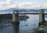
The Burrard Bridge is a five-lane, Art Deco
style, steel truss bridge
constructed in 1930-1932 in Vancouver
, British Columbia
, Canada
. The high, five part bridge on four piers spans False Creek
, connecting downtown Vancouver with Kitsilano
via connections to Burrard Street
on both ends. It is one of three bridges crossing False Creek. The other two bridges are the Granville Bridge, three blocks or 0.5 km (0.310686368324903 mi) to the southeast, and the Cambie Street Bridge
, about 11 blocks or 2 km (1.2 mi) to the east. In addition to the vehicle deck, the Burrard Bridge has sidewalks on both sides, 2.6 m (8.5 ft) wide, the northern one (with a view of English Bay and West Vancouver) for pedestrians and the southern one (with a view of False Creek) now dedicated to cyclists.
The architect
of the Burrard Bridge was George Lister Thornton Sharp, the engineer
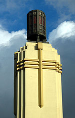
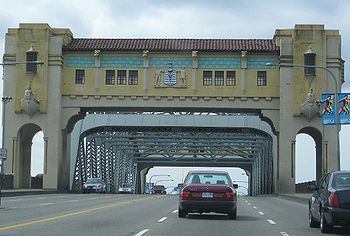
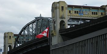
John R. Grant. The bridge's two close approach spans are Warren trusses placed below deck level, while its central span is a Pratt truss placed above deck level to allow greater clearance height for ships passing underneath. The central truss is hidden when crossing the bridge in either direction by vertical extensions of the bridge's masonry piers into imposing concrete towers, connected by overhead galleries, which are embellished with architectural and sculptural details that create a torch-like entrance of pylons
. Busts
of Captain George Vancouver
and Sir Harry Burrard-Neale in ship prow
s jut from the bridge’s superstructure (a V under Vancouver’s bust, a B under Burrard’s).
Unifying the long approaches and the distinctive central span are heavy concrete railings, originally topped with decorative street lamps. These pierced handrails were designed as a kind of visual shutter (stroboscopic effect), so that at a speed of 50 km/h motorists would see through them with an uninterrupted view of the harbour. The effect works at speeds from about 40 to 64 km/h.
, by connecting Burrard Street
to Cedar Street. After completion, Burrard was extended through to the base of downtown and Cedar Street disappeared.
At the opening ceremony, entertainment was provided by two bands, the Kitsilano Boy's Band and the Fireman's Band. An RCAF seaplane
flew under the bridge and later a sugar replica of the bridge was unveiled at the civic reception in the Hotel Vancouver.
G.L. Thornton Sharp, of Sharp and Thompson, was the architect responsible for the distinctive towers on the bridge and its middle galleries. "Both central piers," Sharp told a reporter, "were designed and connected with an overhead gallery across the road. This helped to mask the network of steel in the truss from the two approaches, and has been treated as an entrance gateway to the city." Along their other axis, the full height of the piers above the water also serve to frame a sea entrance gateway, notably for pleasure craft: "by sea and land we prosper". The piers have provision for a rapid transit vertical lift span beneath the highway deck, never installed.
in 2011, in a series showcasing five notable Art Deco structures in Canada.
Since the mid-1990s, the city of Vancouver has investigated various options to rectify the situation. The two most prominent options were 1) to introduce bicycle lanes on the bridge's vehicle deck by reallocating one or more vehicle lanes, and 2) to build horizontal extensions on the outside of the bridge to create additional sidewalk space. Other options have included building an entirely new pedestrian and/or cyclist only bridge, and building another deck on the bridge below the existing deck.
Heritage advocates have been strongly opposed to the construction of outside sidewalk extensions, which would likely alter significantly the historical character of the bridge. Fiscal conservatives have also been opposed to high costs associated with this option.
Many motorists and others have opposed reallocation of vehicle lanes to bicycle lanes, believing that the reduction in vehicle carrying capacity would create excessive traffic problems both on the bridge and on and around alternate crossings, such as the Granville Street Bridge.
On May 31, 2005, a detailed engineering and planning report was presented to Council, reviewing the situation broadly, presenting alternatives, and offering recommendations. (Its computer visualizations of various proposals [esp. pp. 8–12—notably p. 8—and Appendix E] are indispensable illustrations to the discussion. See )
That day Vancouver City Council
voted 10-1 not to follow the recommendations of the report, but to reallocate the two curb-side lanes to cyclists for another trial, as part of Council's plan to increase cycling in Vancouver by 10% for the 2010 Winter Olympics
.
The issue was carried into the municipal election of November 19, 2005.
On December 20, 2005 the newly elected Council voted 6-4 to cancel the lane reallocation trial and to proceed directly to widening the bridge sidewalks as promised in that election.
 In 2006, the City considered removing the concrete railings and widening the bridge deck by outward ('outrigger') sidewalks, at projected cost of over $40 million. (See p. 8 of ) To preserve the bridge's heritage value, such cantilevered structures would not include the bridge's central piers, or towers. Critics of this plan argued that the resulting "pinch points" would defeat the purpose of widening the bridge by creating bottlenecks, through which a greater number of cyclists, skaters and pedestrians must pass over coming decades.
For the third consecutive year, in 2008 Heritage Vancouver listed the Burrard Bridge first on its Top Ten endangered sites in Vancouver. It had ranked fourth in 2005.
Sidewalk expansion was delayed by the Squamish First Nation, which controls the land directly under the south (or west) side of the bridge. For construction to begin, the city would require permission from this group, which has expressed concern that machinery working on the site may affect their land.
The Squamish First Nation also plans to erect advertising billboards on their properties, located at that bridge approach, as well as similar properties by the Lions' Gate Bridge
and the Ironworkers Memorial Second Narrows Crossing
.
 In a late April 2008 report to Council, city engineers raised the estimated cost of widening to $57 million, due to reconsideration of the additional weight to the existing bridge structure and rising construction costs. $61 million was set as a more likely figure.
In Nov. 2008 the current Council, which advocated widening the bridge, was defeated and replaced by a new mayor and Council opposed to the widening but supportive of lane reallocation from vehicles to cyclists. In late January 2009, in an economic downtown and anticipating the 2010 Winter Olympics, the City announced plans for trials of three kinds of auto traffic lane closings, allowing bicycle use of the road surface. This would be supplemented by safety upgrades.
In March 2009, the City of Vancouver delayed discussing the Burrard Bridge Bike Lane Trial at least one month. http://www.straight.com/article-204243/city-staff-report-burrard-bridge-bike-lane-trail-delayed. Council rescheduled meeting to May 5, 2009 to discuss the three kinds of possible trials, to begin summer 2009, were one approved.
On May 7, 2009, Council approved a motion to proceed with option 3 of the proposed trials, to begin in June 2009. The proposed trial began on July 13. It saw the southbound motor-vehicle curb lane and the northbound-side sidewalk allocated to bicycles, with the southbound-side sidewalk allocated to pedestrians. The reassigned lane was separated from motor vehicles by a physical barrier. As part of the trial, traffic pattern changes to accommodate feeder bicycle traffic were also completed on Pacific St., next to the North bridgehead, over complaints from local merchants that cited lack of consultation and possible negative impacts on their businesses. Three days into the trial, a local merchant reported a 46% drop in sales compared to the same days the year before. Six weeks into the trial another local merchant reported a 25% drop in sales, and a local restaurant reported a 30% drop in sales.
Regarding effects on three kinds of traffic: two weeks into the trial, the City of Vancouver released a data report showing daily bicycle travel across the bridge had increased by an average of 30%. The same report indicated little change in pedestrian trips, a slight drop in motor vehicle trips, but no change in motor vehicle travel times between 12th Avenue and Georgia Street along Burrard via the bridge.
In July 2009 a website allowing people to register opposition to the bike lane trail was set up by local realtor and former NPA parks candidate Keith Roy at www.unblockthebridge.ca http://www.unblockthebridge.ca.
(On August 24, 2009 the Vancouver Police Department
announced a sharp increase in bicycle theft, with the first 3 weeks of August experiencing a 53 percent increase over 2008, however, VPD spokesperson Constable Jana McGuinness denied a link between the rise in theft and the lane reallocation trial.)
There has been controversy and protest from neighbouring residents who claim the billboard is unsightly, blocks view corridors of the mountains and even that it is a dangerous distraction to drivers.
There are at least five other similar billboards going up near the Lions Gate Bridge and Ironworkers Memorial Second Narrows Crossing
as well as near the Stawamus Chief
on Highway 99.
The billboards were approved by the federal government. Local and regional governments have acknowledged they have no control over what is done on native reserve lands. The Squamish Nation has stated that the purpose of the billboards is primarily to make money.
On June 9th 2011 a stamp of the bridge's art deco style was released through Canada Post.
Art Deco
Art deco , or deco, is an eclectic artistic and design style that began in Paris in the 1920s and flourished internationally throughout the 1930s, into the World War II era. The style influenced all areas of design, including architecture and interior design, industrial design, fashion and...
style, steel truss bridge
Truss bridge
A truss bridge is a bridge composed of connected elements which may be stressed from tension, compression, or sometimes both in response to dynamic loads. Truss bridges are one of the oldest types of modern bridges...
constructed in 1930-1932 in Vancouver
Vancouver
Vancouver is a coastal seaport city on the mainland of British Columbia, Canada. It is the hub of Greater Vancouver, which, with over 2.3 million residents, is the third most populous metropolitan area in the country,...
, British Columbia
British Columbia
British Columbia is the westernmost of Canada's provinces and is known for its natural beauty, as reflected in its Latin motto, Splendor sine occasu . Its name was chosen by Queen Victoria in 1858...
, Canada
Canada
Canada is a North American country consisting of ten provinces and three territories. Located in the northern part of the continent, it extends from the Atlantic Ocean in the east to the Pacific Ocean in the west, and northward into the Arctic Ocean...
. The high, five part bridge on four piers spans False Creek
False Creek
False Creek is a short inlet in the heart of Vancouver. It separates downtown from the rest of the city. It was named by George Henry Richards during his Hydrographic survey of 1856-63. Science World is located at its eastern end and the Burrard Street Bridge crosses its western end. False Creek is...
, connecting downtown Vancouver with Kitsilano
Kitsilano
Kitsilano is an upmarket neighbourhood on the West Side of the city of Vancouver, British Columbia, Canada.Known colloquially as "Kits", this neighborhood is home to many yuppies, young families and students as well as yoga studios, organic markets, cafes and Vancouver's Greektown. The primary...
via connections to Burrard Street
Burrard Street
Burrard Street is a major thoroughfare in Vancouver, British Columbia, Canada. It is the central street of Downtown Vancouver and the Financial District. The street is named for Burrard Inlet, located at its northern terminus, which in turn is named for Sir Harry Burrard-Neale.The street starts at...
on both ends. It is one of three bridges crossing False Creek. The other two bridges are the Granville Bridge, three blocks or 0.5 km (0.310686368324903 mi) to the southeast, and the Cambie Street Bridge
Cambie Street Bridge
The Cambie Bridge is a six-lane symmetric, precast, varying-depth-post tension-box girder bridge spanning False Creek in Vancouver, British Columbia. The current bridge opened in 1985, but is the third bridge at the same location...
, about 11 blocks or 2 km (1.2 mi) to the east. In addition to the vehicle deck, the Burrard Bridge has sidewalks on both sides, 2.6 m (8.5 ft) wide, the northern one (with a view of English Bay and West Vancouver) for pedestrians and the southern one (with a view of False Creek) now dedicated to cyclists.
The architect
Architect
An architect is a person trained in the planning, design and oversight of the construction of buildings. To practice architecture means to offer or render services in connection with the design and construction of a building, or group of buildings and the space within the site surrounding the...
of the Burrard Bridge was George Lister Thornton Sharp, the engineer
Engineer
An engineer is a professional practitioner of engineering, concerned with applying scientific knowledge, mathematics and ingenuity to develop solutions for technical problems. Engineers design materials, structures, machines and systems while considering the limitations imposed by practicality,...
John R. Grant. The bridge's two close approach spans are Warren trusses placed below deck level, while its central span is a Pratt truss placed above deck level to allow greater clearance height for ships passing underneath. The central truss is hidden when crossing the bridge in either direction by vertical extensions of the bridge's masonry piers into imposing concrete towers, connected by overhead galleries, which are embellished with architectural and sculptural details that create a torch-like entrance of pylons
Pylon (architecture)
Pylon is the Greek term for a monumental gateway of an Egyptian temple It consists of two tapering towers, each surmounted by a cornice, joined by a less elevated section which enclosed the entrance between them. The entrance was generally about half the height of the towers...
. Busts
Bust (sculpture)
A bust is a sculpted or cast representation of the upper part of the human figure, depicting a person's head and neck, as well as a variable portion of the chest and shoulders. The piece is normally supported by a plinth. These forms recreate the likeness of an individual...
of Captain George Vancouver
George Vancouver
Captain George Vancouver RN was an English officer of the British Royal Navy, best known for his 1791-95 expedition, which explored and charted North America's northwestern Pacific Coast regions, including the coasts of contemporary Alaska, British Columbia, Washington and Oregon...
and Sir Harry Burrard-Neale in ship prow
Prow
thumb|right|295pxThe prow is the forward most part of a ship's bow that cuts through the water. The prow is the part of the bow above the waterline. The terms prow and bow are often used interchangeably to describe the most forward part of a ship and its surrounding parts...
s jut from the bridge’s superstructure (a V under Vancouver’s bust, a B under Burrard’s).
Unifying the long approaches and the distinctive central span are heavy concrete railings, originally topped with decorative street lamps. These pierced handrails were designed as a kind of visual shutter (stroboscopic effect), so that at a speed of 50 km/h motorists would see through them with an uninterrupted view of the harbour. The effect works at speeds from about 40 to 64 km/h.
History
The Burrard Bridge, opened July 1, 1932, was built to provide a high-level crossing from Vancouver to the southwestern neighbourhoods in KitsilanoKitsilano
Kitsilano is an upmarket neighbourhood on the West Side of the city of Vancouver, British Columbia, Canada.Known colloquially as "Kits", this neighborhood is home to many yuppies, young families and students as well as yoga studios, organic markets, cafes and Vancouver's Greektown. The primary...
, by connecting Burrard Street
Burrard Street
Burrard Street is a major thoroughfare in Vancouver, British Columbia, Canada. It is the central street of Downtown Vancouver and the Financial District. The street is named for Burrard Inlet, located at its northern terminus, which in turn is named for Sir Harry Burrard-Neale.The street starts at...
to Cedar Street. After completion, Burrard was extended through to the base of downtown and Cedar Street disappeared.
At the opening ceremony, entertainment was provided by two bands, the Kitsilano Boy's Band and the Fireman's Band. An RCAF seaplane
Seaplane
A seaplane is a fixed-wing aircraft capable of taking off and landing on water. Seaplanes that can also take off and land on airfields are a subclass called amphibian aircraft...
flew under the bridge and later a sugar replica of the bridge was unveiled at the civic reception in the Hotel Vancouver.
G.L. Thornton Sharp, of Sharp and Thompson, was the architect responsible for the distinctive towers on the bridge and its middle galleries. "Both central piers," Sharp told a reporter, "were designed and connected with an overhead gallery across the road. This helped to mask the network of steel in the truss from the two approaches, and has been treated as an entrance gateway to the city." Along their other axis, the full height of the piers above the water also serve to frame a sea entrance gateway, notably for pleasure craft: "by sea and land we prosper". The piers have provision for a rapid transit vertical lift span beneath the highway deck, never installed.
Recognition
Burrard Bridge has been assessed by heritage consultants retained by the City of Vancouver as being in the top category of historic buildings in Vancouver. The bridge appeared on a stamp issued by Canada PostCanada Post
Canada Post Corporation, known more simply as Canada Post , is the Canadian crown corporation which functions as the country's primary postal operator...
in 2011, in a series showcasing five notable Art Deco structures in Canada.
Proposed bicycle lanes or widening
When constructed, the Burrard Bridge did not have dedicated lanes for cyclists, who shared the bridge's six vehicle lanes with motorists. Later, as traffic volume grew and speed limits were increased on the bridge to 60 km/h, cyclists were directed to share the bridge's sidewalks with pedestrians. Over time, the volume of pedestrians and cyclists on the 2.6 m (8.5 ft) sidewalks created a dangerous situation, with several accidents occurring, which resulted in at least one successful lawsuit against the city.Since the mid-1990s, the city of Vancouver has investigated various options to rectify the situation. The two most prominent options were 1) to introduce bicycle lanes on the bridge's vehicle deck by reallocating one or more vehicle lanes, and 2) to build horizontal extensions on the outside of the bridge to create additional sidewalk space. Other options have included building an entirely new pedestrian and/or cyclist only bridge, and building another deck on the bridge below the existing deck.
Heritage advocates have been strongly opposed to the construction of outside sidewalk extensions, which would likely alter significantly the historical character of the bridge. Fiscal conservatives have also been opposed to high costs associated with this option.
Many motorists and others have opposed reallocation of vehicle lanes to bicycle lanes, believing that the reduction in vehicle carrying capacity would create excessive traffic problems both on the bridge and on and around alternate crossings, such as the Granville Street Bridge.
Timeline
Beginning March 26, 1996, in a six month trial by the City, one commuter lane was closed to automobile traffic and made into a temporary cyclist lane. However after one week, the City was forced to revert the lane to its original purpose, due to outrage by some motorists.On May 31, 2005, a detailed engineering and planning report was presented to Council, reviewing the situation broadly, presenting alternatives, and offering recommendations. (Its computer visualizations of various proposals [esp. pp. 8–12—notably p. 8—and Appendix E] are indispensable illustrations to the discussion. See )
That day Vancouver City Council
Vancouver City Council
Vancouver City Council is the governing body of the City of Vancouver, British Columbia, Canada.The city is governed by the Vancouver Charter, not the Community Charter and the Local Government Act which are used for other municipal governments...
voted 10-1 not to follow the recommendations of the report, but to reallocate the two curb-side lanes to cyclists for another trial, as part of Council's plan to increase cycling in Vancouver by 10% for the 2010 Winter Olympics
2010 Winter Olympics
The 2010 Winter Olympics, officially the XXI Olympic Winter Games or the 21st Winter Olympics, were a major international multi-sport event held from February 12–28, 2010, in Vancouver, British Columbia, Canada, with some events held in the suburbs of Richmond, West Vancouver and the University...
.
The issue was carried into the municipal election of November 19, 2005.
On December 20, 2005 the newly elected Council voted 6-4 to cancel the lane reallocation trial and to proceed directly to widening the bridge sidewalks as promised in that election.
For the third consecutive year, in 2008 Heritage Vancouver listed the Burrard Bridge first on its Top Ten endangered sites in Vancouver. It had ranked fourth in 2005.
Sidewalk expansion was delayed by the Squamish First Nation, which controls the land directly under the south (or west) side of the bridge. For construction to begin, the city would require permission from this group, which has expressed concern that machinery working on the site may affect their land.
The Squamish First Nation also plans to erect advertising billboards on their properties, located at that bridge approach, as well as similar properties by the Lions' Gate Bridge
Lions' Gate Bridge
The Lions Gate Bridge, officially known as the First Narrows Bridge, is a suspension bridge that crosses the first narrows of Burrard Inlet and connects the City of Vancouver, British Columbia, to the North Shore municipalities of the District of North Vancouver, the City of North Vancouver, and...
and the Ironworkers Memorial Second Narrows Crossing
Ironworkers Memorial Second Narrows Crossing
The Ironworkers Memorial Second Narrows Crossing, also called the Ironworkers Memorial Bridge, is the second bridge constructed at the Second Narrows of Burrard Inlet in Vancouver, British Columbia, Canada...
.
In Nov. 2008 the current Council, which advocated widening the bridge, was defeated and replaced by a new mayor and Council opposed to the widening but supportive of lane reallocation from vehicles to cyclists. In late January 2009, in an economic downtown and anticipating the 2010 Winter Olympics, the City announced plans for trials of three kinds of auto traffic lane closings, allowing bicycle use of the road surface. This would be supplemented by safety upgrades.
In March 2009, the City of Vancouver delayed discussing the Burrard Bridge Bike Lane Trial at least one month. http://www.straight.com/article-204243/city-staff-report-burrard-bridge-bike-lane-trail-delayed. Council rescheduled meeting to May 5, 2009 to discuss the three kinds of possible trials, to begin summer 2009, were one approved.
On May 7, 2009, Council approved a motion to proceed with option 3 of the proposed trials, to begin in June 2009. The proposed trial began on July 13. It saw the southbound motor-vehicle curb lane and the northbound-side sidewalk allocated to bicycles, with the southbound-side sidewalk allocated to pedestrians. The reassigned lane was separated from motor vehicles by a physical barrier. As part of the trial, traffic pattern changes to accommodate feeder bicycle traffic were also completed on Pacific St., next to the North bridgehead, over complaints from local merchants that cited lack of consultation and possible negative impacts on their businesses. Three days into the trial, a local merchant reported a 46% drop in sales compared to the same days the year before. Six weeks into the trial another local merchant reported a 25% drop in sales, and a local restaurant reported a 30% drop in sales.
Regarding effects on three kinds of traffic: two weeks into the trial, the City of Vancouver released a data report showing daily bicycle travel across the bridge had increased by an average of 30%. The same report indicated little change in pedestrian trips, a slight drop in motor vehicle trips, but no change in motor vehicle travel times between 12th Avenue and Georgia Street along Burrard via the bridge.
In July 2009 a website allowing people to register opposition to the bike lane trail was set up by local realtor and former NPA parks candidate Keith Roy at www.unblockthebridge.ca http://www.unblockthebridge.ca.
(On August 24, 2009 the Vancouver Police Department
Vancouver Police Department
The Vancouver Police Department is the police force for the City of Vancouver in British Columbia, Canada. It is one of several police departments within the Metro Vancouver Area and is the second largest police force in the province after RCMP "E" Division.VPD was the first Canadian police force...
announced a sharp increase in bicycle theft, with the first 3 weeks of August experiencing a 53 percent increase over 2008, however, VPD spokesperson Constable Jana McGuinness denied a link between the rise in theft and the lane reallocation trial.)
Electronic Billboard
In December, 2009 the Squamish First Nation erected an electronic billboard on their land adjacent to the south end of the bridge on the west side. It is visible to traffic travelling in both directions on the bridge and each screen (one for each direction) measures 9 meters wide x 3 meters tall. The advertisements will cycle evey 10 seconds.There has been controversy and protest from neighbouring residents who claim the billboard is unsightly, blocks view corridors of the mountains and even that it is a dangerous distraction to drivers.
There are at least five other similar billboards going up near the Lions Gate Bridge and Ironworkers Memorial Second Narrows Crossing
Ironworkers Memorial Second Narrows Crossing
The Ironworkers Memorial Second Narrows Crossing, also called the Ironworkers Memorial Bridge, is the second bridge constructed at the Second Narrows of Burrard Inlet in Vancouver, British Columbia, Canada...
as well as near the Stawamus Chief
Stawamus Chief
The Stawamus Chief is a granite dome located adjacent to the town of Squamish, British Columbia. It towers over above the waters of nearby Howe Sound...
on Highway 99.
The billboards were approved by the federal government. Local and regional governments have acknowledged they have no control over what is done on native reserve lands. The Squamish Nation has stated that the purpose of the billboards is primarily to make money.
On June 9th 2011 a stamp of the bridge's art deco style was released through Canada Post.
External links
- Bridges of Vancouver Pictures of Burrard Bridge
- The History of Metropolitan Vancouver
- Heritage Vancouver
- KatKam Webcam of Burrard Bridge