

Frenchglen, Oregon
Encyclopedia
Unincorporated area
In law, an unincorporated area is a region of land that is not a part of any municipality.To "incorporate" in this context means to form a municipal corporation, a city, town, or village with its own government. An unincorporated community is usually not subject to or taxed by a municipal government...
community in Harney County
Harney County, Oregon
-National protected areas:*Malheur National Forest *Malheur National Wildlife Refuge*Ochoco National Forest -Demographics:As of the census of 2000, there were 7,609 people, 3,036 households, and 2,094 families residing in the county. The population density was 1 people per square mile...
, Oregon
Oregon
Oregon is a state in the Pacific Northwest region of the United States. It is located on the Pacific coast, with Washington to the north, California to the south, Nevada on the southeast and Idaho to the east. The Columbia and Snake rivers delineate much of Oregon's northern and eastern...
, United States
United States
The United States of America is a federal constitutional republic comprising fifty states and a federal district...
. It is 60 miles (96.6 km) south of Burns
Burns, Oregon
Burns is a city in and the county seat of Harney County, Oregon, United States. As of the 2010 census the population was 2,806.-History:Burns was established in the early 1880s and incorporated upon Harney county's creation in 1889...
on Oregon Route 205
Oregon Route 205
Oregon Route 205 is an Oregon state highway running from OR 78 near Burns to Roaring Springs Ranch. OR 205 is known as the Frenchglen Highway No. 440 . It is long and runs north–south, entirely within Harney County.OR 205 has been designated the High Desert Discovery Scenic Byway by the...
and its population is approximately 12.
Frenchglen is near Steens Mountain
Steens Mountain
Steens Mountain is a large fault-block mountain in the southeastern part of the U.S. state of Oregon. Located in Harney County, it stretches some and rises from an elevation of about above the Alvord Desert to its peak at...
and Malheur National Wildlife Refuge
Malheur National Wildlife Refuge
Malheur National Wildlife Refuge is located roughly south of the town of Burns, Oregon. The refuge area is roughly T shaped with the southernmost base at Frenchglen, the left top at Malheur Lake and the right top at Harney Lake....
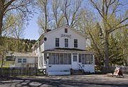
, and is home to the historic Frenchglen Hotel
Frenchglen Hotel State Heritage Site
The Frenchglen Hotel State Heritage Site is a hotel in the sparsely-populated southeast area of Oregon, United States. It is located in the unincorporated community of Frenchglen, near the base of Steens Mountain and at the northern end of the loop road that ascends almost to the mountain's summit...
. The town has a K-8 school divided into two classes. The area is known as a haven for birdwatching.
History
The community is named after the French-Glenn Livestock Company, founded by Dr. Hugh J. GlennHugh J. Glenn
Hugh James Glenn was a prominent businessman and politician in California. Glenn was born near Staunton, Virginia, and grew up in Monroe County, Missouri. He was educated as a physician at McDowell's Medical College in St. Louis, Missouri. Glenn served with Colonel Alexander William Doniphan's...
and later joined by his son-in-law, Peter French
Peter French
Peter French was a rancher in the western United States in the late 19th century. The community of Frenchglen, Oregon was partially named for him.-Early life:...
. French-Glenn built its headquarters there in 1872.
External links
- Frenchglen Hotel from Oregon Parks and Recreation DepartmentOregon Parks and Recreation DepartmentThe Oregon Parks and Recreation Department , officially known as the State Parks and Recreation Department, is the government agency of the U.S. state of Oregon which operates its system of state parks...
- History of Frenchglen from Harney County Chamber of Commerce