

Diffa (department)
Encyclopedia
Diffa is an administrative Region of Niger
, the capital of the region is the city of Diffa
.
between 10° 30’ and 15° 35’ longitude East and 13° 04’ and 18° 00’ latitude North. It covers 156 906 km², and is bordered to the north by Agadez Region, Zinder Region to the west, and to the south and east by the Federal Republic of Nigeria
and the Republic of Chad
.
Diffa Region borders:
Domestically, it borders the following Regions:
, Toubou
s, Touregs, Fula
, and the so-called Diffa Arabs
. The total annual growth rate is around 1.2 % and it is one of the least populated areas of Niger ( 2.2 people/km²).
The population is 85% sedentary and 15 % nomadic, practicing seasonal migration with their livestock (Transhumism). The demographic structure, fairly constant over time, is 37% aged less than 20, 57% between 20 - 60, and 6% older than 60 years old.
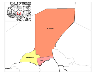 Diffa Region is divided into three Departments
:
The Region also includes three Urban Communes
, a number of Rural Communes, four Cantons, and over twenty Groupments (administrative councils of nomadic communities).
The Urban Communes are Diffa
, Maïné-Soroa
, N'guigmi
; while the Rural Communes include Bosso
, Chétimari
, Goudoumaria
, N'gourti
, Kabléwa
, Nguel beyli, and Gueskérou
.
, especially drought tolerant varieties. One third of arable land is devoted to farming: almost 105,000 hectares farmed of the 299500 hectares of arable land.
Areas of the east and south also grow rice
and maize
. Irrigation in the valleys around Maïné-Soroa
make this possible, as well as does the edge of Lake Chad
( 3,000 km² in the far east) and the seasonal Komadougou Yobe river valley in the south, which forms around 150km of the border with Nigeria
.
Despite this the Diffa Region is among the most unproductive agricultural areas in Niger, and all of West Africa, making it especially vulnerable to drought and famine.
Niger
Niger , officially named the Republic of Niger, is a landlocked country in Western Africa, named after the Niger River. It borders Nigeria and Benin to the south, Burkina Faso and Mali to the west, Algeria and Libya to the north and Chad to the east...
, the capital of the region is the city of Diffa
Diffa
Diffa is a city and Urban Commune in the extreme southeast of Niger, near that country's border with Nigeria, with a population of 23,600 . It is the administrative seat of both Diffa Region, and the smaller Diffa Department...
.
Situation
Diffa Region is situated in the extreme south east of NigerNiger
Niger , officially named the Republic of Niger, is a landlocked country in Western Africa, named after the Niger River. It borders Nigeria and Benin to the south, Burkina Faso and Mali to the west, Algeria and Libya to the north and Chad to the east...
between 10° 30’ and 15° 35’ longitude East and 13° 04’ and 18° 00’ latitude North. It covers 156 906 km², and is bordered to the north by Agadez Region, Zinder Region to the west, and to the south and east by the Federal Republic of Nigeria
Nigeria
Nigeria , officially the Federal Republic of Nigeria, is a federal constitutional republic comprising 36 states and its Federal Capital Territory, Abuja. The country is located in West Africa and shares land borders with the Republic of Benin in the west, Chad and Cameroon in the east, and Niger in...
and the Republic of Chad
Chad
Chad , officially known as the Republic of Chad, is a landlocked country in Central Africa. It is bordered by Libya to the north, Sudan to the east, the Central African Republic to the south, Cameroon and Nigeria to the southwest, and Niger to the west...
.
Diffa Region borders:
- Bourkou-Ennedi-Tibesti Department, Chad - northeast
- Kanem Department, ChadKanem DepartmentKanem is one of 2 departments which make up the region of Kanem in Chad. The capital is Mao.The department is divided into 4 sub-prefectures:*Kekedina*Mao*Melea*Wadjigui...
- east - Lac Department, Chad - southeast
- Borno State, NigeriaBorno StateBorno State is a state in north-eastern Nigeria. Its capital is Maiduguri. The state was formed in 1976 from the split of the North-Eastern State...
- south - Yobe State, NigeriaYobe StateYobe State is a state located in Northern Nigeria. A mainly agricultural state, it was created on August 27, 1991. Yobe state was carved out of present-day Borno State. The capital of Yobe state is Damaturu.-Geography:...
- southwest
Domestically, it borders the following Regions:
- Zinder Region - west
- Agadez Region - north
Population
The population was estimated in 2000 at 216,245 and 346,595 inhabitants in the 2001 census, consisting of ethnic Kanouris, HausasHausa people
The Hausa are one of the largest ethnic groups in West Africa. They are a Sahelian people chiefly located in northern Nigeria and southeastern Niger, but having significant numbers living in regions of Cameroon, Ghana, Cote d'Ivoire, Chad and Sudan...
, Toubou
Toubou
The Tubu are an ethnic group that live mainly in northern Chad, but also in Libya, Niger and Sudan....
s, Touregs, Fula
Fula people
Fula people or Fulani or Fulbe are an ethnic group spread over many countries, predominantly in West Africa, but found also in Central Africa and Sudanese North Africa...
, and the so-called Diffa Arabs
Diffa Arabs
Diffa Arabs is the Nigerien name given to Arab nomadic tribespeople living in eastern Niger, mostly in the Diffa Region...
. The total annual growth rate is around 1.2 % and it is one of the least populated areas of Niger ( 2.2 people/km²).
The population is 85% sedentary and 15 % nomadic, practicing seasonal migration with their livestock (Transhumism). The demographic structure, fairly constant over time, is 37% aged less than 20, 57% between 20 - 60, and 6% older than 60 years old.
Administrative subdivisions
Departments of Niger
||The Regions of Niger are subdivided into 63 Departments . Before the devolution program on 1999-2005, these Departments were styled arrondissements. Confusingly, the next level up had, before 2002-2005 been styled Departments. Prior to a revision in 2011, there had been 36 Departments. A draft...
:
- Diffa DepartmentDiffa DepartmentDiffa is a department of the Diffa Region in Niger. It is bordered by Chad to the east. Its capital lies at the city of Diffa....
- Maïne-Soroa DepartmentMaine-soroa DepartmentMaine-soroa is a department of the Diffa Region in Niger. Its capital lies at the city of Maine-soroa.-Population:The department's population is above 50,000, and is largely made up of ethnic Kanouris and Fula, both cultures with longstanding pastoral semi-nomadic traditions....
- N'guigmi DepartmentN'guigmi DepartmentN'guigmi is a department of the Diffa Region in Niger. Its capital lies at the city of N'guigmi....
The Region also includes three Urban Communes
Communes of Niger
The Departments of Niger are subdivided into communes. As of 2005, in the seven Regions and one Capital Area, there were 36 départements, divided into 265 communes, 122 cantons and 81 groupements...
, a number of Rural Communes, four Cantons, and over twenty Groupments (administrative councils of nomadic communities).
The Urban Communes are Diffa
Diffa
Diffa is a city and Urban Commune in the extreme southeast of Niger, near that country's border with Nigeria, with a population of 23,600 . It is the administrative seat of both Diffa Region, and the smaller Diffa Department...
, Maïné-Soroa
Maine-Soroa
Maine-Soroa is a town in southeastern Niger, the capital of the Maine-soroa Department, and is in turn part of Diffa Region. Population 10,176 .-Economy:...
, N'guigmi
N'guigmi
N'guigmi is a city and Commune of fifteen thousand in the eastern most part of Niger, very near to Lake Chad - lying on its shore until the lake retreated....
; while the Rural Communes include Bosso
Bosso, Niger
-References:...
, Chétimari
Chetimari
-References:...
, Goudoumaria
Goudoumaria
Goudoumaria, Niger is a town in the southeast of the country, in Diffa Region, northwest of Diffa. Goudoumaria is an administrative post in the Maine-Soroa Department, and is approx. 50km north of the Nigerian border and approx...
, N'gourti
N'Gourti
-References:...
, Kabléwa
Kablewa
-References:...
, Nguel beyli, and Gueskérou
Gueskerou
Gueskerou is a town in southeastern Niger....
.
Regional economy
The economy of the Diffa Region is primarily agricultural, based upon pastoralism and farming. The major crop, grown both for subsistence and sale, is MilletMillet
The millets are a group of small-seeded species of cereal crops or grains, widely grown around the world for food and fodder. They do not form a taxonomic group, but rather a functional or agronomic one. Their essential similarities are that they are small-seeded grasses grown in difficult...
, especially drought tolerant varieties. One third of arable land is devoted to farming: almost 105,000 hectares farmed of the 299500 hectares of arable land.
Areas of the east and south also grow rice
Rice
Rice is the seed of the monocot plants Oryza sativa or Oryza glaberrima . As a cereal grain, it is the most important staple food for a large part of the world's human population, especially in East Asia, Southeast Asia, South Asia, the Middle East, and the West Indies...
and maize
Maize
Maize known in many English-speaking countries as corn or mielie/mealie, is a grain domesticated by indigenous peoples in Mesoamerica in prehistoric times. The leafy stalk produces ears which contain seeds called kernels. Though technically a grain, maize kernels are used in cooking as a vegetable...
. Irrigation in the valleys around Maïné-Soroa
Maine-Soroa
Maine-Soroa is a town in southeastern Niger, the capital of the Maine-soroa Department, and is in turn part of Diffa Region. Population 10,176 .-Economy:...
make this possible, as well as does the edge of Lake Chad
Lake Chad
Lake Chad is a historically large, shallow, endorheic lake in Africa, whose size has varied over the centuries. According to the Global Resource Information Database of the United Nations Environment Programme, it shrank as much as 95% from about 1963 to 1998; yet it also states that "the 2007 ...
( 3,000 km² in the far east) and the seasonal Komadougou Yobe river valley in the south, which forms around 150km of the border with Nigeria
Nigeria
Nigeria , officially the Federal Republic of Nigeria, is a federal constitutional republic comprising 36 states and its Federal Capital Territory, Abuja. The country is located in West Africa and shares land borders with the Republic of Benin in the west, Chad and Cameroon in the east, and Niger in...
.
Despite this the Diffa Region is among the most unproductive agricultural areas in Niger, and all of West Africa, making it especially vulnerable to drought and famine.
See also
- Regions of NigerRegions of Niger||Niger is divided into 7 Regions . Each department's capital is the same as its name.-Current regions:*Agadez Region*Diffa Region*Dosso Region*Maradi Region*Tahoua Region*Tillabéri Region*Zinder Region...
- Departments of NigerDepartments of Niger||The Regions of Niger are subdivided into 63 Departments . Before the devolution program on 1999-2005, these Departments were styled arrondissements. Confusingly, the next level up had, before 2002-2005 been styled Departments. Prior to a revision in 2011, there had been 36 Departments. A draft...
- Communes of NigerCommunes of NigerThe Departments of Niger are subdivided into communes. As of 2005, in the seven Regions and one Capital Area, there were 36 départements, divided into 265 communes, 122 cantons and 81 groupements...
- 2010 Sahel famine2010 Sahel famineA large-scale, drought-induced famine occurred in Africa's Sahel region and many parts of the neighboring Sénégal River Area and Horn of Africa from February to August 2010...