
Delaware Water Gap
Encyclopedia
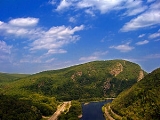
The Delaware Water Gap is on the border of New Jersey
and Pennsylvania
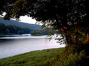
where the Delaware River
cuts through a large ridge of the Appalachian Mountains
. A water gap
is a geological feature where a river cuts through a mountain ridge.
The Delaware Water Gap is the site of the Delaware Water Gap National Recreation Area
, which is used primarily for recreation
al purposes, such as rafting
, canoeing
, swimming, fishing
, hiking
and rock climbing
. With a fishing license, one can fish in the Delaware for carp
, shad
and other fish.
 The Delaware Water gap began to form four hundred fifty million years ago when quartz pebbles were deposited in a shallow sea, on top of the Ordovician Martinsburg shale. The Martinsburg shale was uplifted when a chain of volcanic islands collided with proto North America around four hundred fifty million years ago. These islands went over the North American plate. This collision deposited rock on top of the North American plate. This is how the Highlands and Kittatinny Valley were created.
Then around four hundred million years ago a small continent that was thin and long collided with proto North America. Geologic pressure twisted the Silurian Shawangunk Conglomerate, thereby breaking or shattering the gray quartzite as it uplifted. Pressure from this continental strike compressed the bed rock of the quartzite, created heat, allowed the quartzite to bend and melt silica to bond the quartz pebbles and other conglomerate together. Geologic pressure forced the quartzite up, and the Delaware River slowly cut its path through the shattered quartzite. Otherwise the river may not have been able to cut its path through the quartzite. As one can see, the top ridge of the Kittatinny is offset from the top of Blue Mountain.
Millions of years of rain, ice, snow and wind erosion shaped the area. The Wisconsin glacier, which occurred between 21,000 B.C. to 13,000 B.C., covered the entire Kittatinny Ridge and ended near Belvidere. This was the final touch to the Gap's look.
The mountain is of the Silurian Shawangunk conglomerate. This is a gray quartzite, which makes the mountain highly resistant to weathering. The Silurian High Fall formation of sandstone is on the western side of the gap near the base. The eastern side of the Mountain has the Ordovician Martinsburg shale. Sedimentary rock is along the river. The Bloomsburg Red Beds—a red shale—are at the Gap under Dunsfield Creek.
The width at the base of the Gap is about 300 meters at River level and 1400 meters at the top. The river at this spot is 283 feet above sea level.
The ridge of the Appalachians that the Delaware crosses is called the Blue Mountains
in Pennsylvania and the Kittatinny Ridge
in New Jersey. This is the first major ridge of the Appalachian mountains. The New Jersey mountain is Mount Tammany
;named after the Native American Chief Tamanend. The Pennsylvania mountain is Mount Minsi
, named after the Native American Tribe of the area. The summit of Tammany is 1540 ft (469.4 m) above sea level.
Dunfield Creek drains the Mountain and flows into the Delaware River. This creek flows over the Bloomsburg Red Beds of shale.
To the east of the Gap is the Great Kittatinny Valley which is wide, and goes northeast along the Kittatinny Mountain. The Paulinskill River drains the valley in this area.
Paleo Indians were north of the Gap at Paraquarry, as found at the Harry's Farm Site. Charcoal from this place has been dated at 5430 BC + or - 120 years. However Caribou bones found at the Dutchess Quarry Cave near Florida, New York
, has the bones dated at 10,580 BC + or - 370 years. So that would place early man at 10,210 BC to 10,950 BC in Florida, New York. Another Paleo Indian site located in Pennsylvania along the Delaware just north of the Gap, has carbon dating of charcoal at 8900BC. Most likely Paleo Indians were at the Gap around 10500 BC.
The Lenni Lenape, Native Americans, came from the west and inhabited the area for several thousand years. They hunted, fished and trapped, in this area. Later came the Dutch and other European settlers to the area in the very late 17th century.
The rocks of the Gap were steep along the rivers edge on both sides of the river. Foot travel was not possible along the river through the Gap.
passes through the gap on the New Jersey side via the Delaware Water Gap Toll Bridge
, while the Pennsylvania portion of the New Jersey Cut-Off
mainline of the Delaware, Lackawanna and Western Railroad
comes into Slateford, PA. The Pennsylvania Northeast Regional Rail Authority
owns the trackage in the Water Gap area and is operated by the Delaware-Lackawanna Railroad
. Pennsylvania Route 611
, which is adjacent to the railroad for most of way through the Gap, occupies the right-of-way of a former trolley line. Interstate 80 occupies the former right-of-way of the New York, Susquehanna and Western Railway
.
 The Delaware Water Gap National Recreation Area
was created in 1965 by President Johnson. There are two offices, one located in New Jersey near the Delaware River and the other in Pennsylvania, north of the Gap.
The Gray Dot Trail is a very steep climber's trail that goes from I-80 to the top of the gap along the top edge of the big wall. This trail intersects with the blue dot and red dot trail at the top. The hike up the gray dot trail and down the red dot trail takes about two hours and fifteen minutes. The blue dot also goes to the top, but is about a 3-mile hike that is less steep than the red dot.
The Appalachan Trail crosses the Delaware River on the Route 80 Bridge and goes up Dunfield Creek to Sunfish Pond and continues northeast to Stokes State Forest. The trail crosses Route 206 and continues along the top of Kittatinny Mountain to High Point State Park where the trail turns east and eventually goes into New York State.
from a half inch to four inches thick. Most cracks are horizontal, flaring out near the edge. Adjustable cams are probably the best for climbers to use. Most climbing is done on the New Jersey side due to easier access. Climbers can walk along the cement wall along I-80 until they pass the big wall on I-80 and then go up a path that follows the base of the big wall.
On the Pennsylvania side (Mount Minsi), park at the cold air cave pull-off on Route 611, then follow a steep and strenuous trail up the talus to the cliffs. Most routes are then to the left (south). In recent years, the PA side has been closed to climbing during the nesting season for Peregrine Falcons, this has resulted in overgrowth of trails and climbing routes, providing an experience closer to the natural state than found at more popular climbing destinations.
There are about one hundred climbs on the New Jersey side. This is truly multi-pitch climbing due to the height of the wall. Once at the top of the wall on the New Jersey side, one can rappel down, climb down in the big chimney, or follow the gray dot trail back to Route 80.
Hanging belays also occur on the wall depending on the climbing route. Climbs on the wall range from 5.1 to 5.13 on the Yosemite scale of climbing. Lunch on the wall is spectacular.
The path that follows the base of the big wall on the New Jersey side is steep, with poison ivy in the spring and summer. Occasionally there is falling rock, so one must use caution. The wall also has poison ivy growing on it. The sun shines on the wall from 10am to 3pm. The sound of Route 80 can be heard while climbing and is somewhat loud in nature. This can severely affect communication between lead climber and belayer. This is one reason most lead climbers do not go to far from the belayer. The lead climber then sets up protection to belay the second.
, but was never built, although the land for the proposed reservoir had already been purchased. The Delaware Water Gap National Recreation Area was created from the land acquired for the planned reservoir.
of the Boy Scouts of America
operated Weygadt Scout Reservation in the Delaware Water Gap at the base of Mount Tammany from 1931 until 1968. The Reservation was originally home to two Scout camps — the Easton Council's Camp Weygadt on the southern part of the reservation and the Bethlehem Area Council's
Camp Minsi on the northern section of the reservation. In the later part of the 1930s, the Bethlehem Council moved their to the Poconos, and the entire reservation in the Water Gap became Camp Weygadt. Camp Minsi is now located in Pocono Summit, Pennsylvania
on the shores of Stillwater Lake
.
Pahaquarra Boy Scout Camp was located on on the New Jersey side of the Delaware Water Gap on Old Mine Road. The camp served Boy Scouts
from the George Washington Council
.
New Jersey
New Jersey is a state in the Northeastern and Middle Atlantic regions of the United States. , its population was 8,791,894. It is bordered on the north and east by the state of New York, on the southeast and south by the Atlantic Ocean, on the west by Pennsylvania and on the southwest by Delaware...
and Pennsylvania
Pennsylvania
The Commonwealth of Pennsylvania is a U.S. state that is located in the Northeastern and Mid-Atlantic regions of the United States. The state borders Delaware and Maryland to the south, West Virginia to the southwest, Ohio to the west, New York and Ontario, Canada, to the north, and New Jersey to...
where the Delaware River
Delaware River
The Delaware River is a major river on the Atlantic coast of the United States.A Dutch expedition led by Henry Hudson in 1609 first mapped the river. The river was christened the South River in the New Netherland colony that followed, in contrast to the North River, as the Hudson River was then...
cuts through a large ridge of the Appalachian Mountains
Appalachian Mountains
The Appalachian Mountains #Whether the stressed vowel is or ,#Whether the "ch" is pronounced as a fricative or an affricate , and#Whether the final vowel is the monophthong or the diphthong .), often called the Appalachians, are a system of mountains in eastern North America. The Appalachians...
. A water gap
Water gap
A water gap is an opening or notch which flowing water has carved through a mountain range. Water gaps often offer a practical route for road and rail transport to cross mountain ridges.- Geology :...
is a geological feature where a river cuts through a mountain ridge.
The Delaware Water Gap is the site of the Delaware Water Gap National Recreation Area
Delaware Water Gap National Recreation Area
Delaware Water Gap National Recreation Area, administered by the National Park Service, preserves almost of land along the Delaware River's New Jersey and Pennsylvania shores, stretching from the Delaware Water Gap northward almost to the New York state line...
, which is used primarily for recreation
Recreation
Recreation is an activity of leisure, leisure being discretionary time. The "need to do something for recreation" is an essential element of human biology and psychology. Recreational activities are often done for enjoyment, amusement, or pleasure and are considered to be "fun"...
al purposes, such as rafting
Rafting
Rafting or white water rafting is a challenging recreational outdoor activity using an inflatable raft to navigate a river or other bodies of water. This is usually done on white water or different degrees of rough water, in order to thrill and excite the raft passengers. The development of this...
, canoeing
Canoeing
Canoeing is an outdoor activity that involves a special kind of canoe.Open canoes may be 'poled' , sailed, 'lined and tracked' or even 'gunnel-bobbed'....
, swimming, fishing
Fishing
Fishing is the activity of trying to catch wild fish. Fish are normally caught in the wild. Techniques for catching fish include hand gathering, spearing, netting, angling and trapping....
, hiking
Hiking
Hiking is an outdoor activity which consists of walking in natural environments, often in mountainous or other scenic terrain. People often hike on hiking trails. It is such a popular activity that there are numerous hiking organizations worldwide. The health benefits of different types of hiking...
and rock climbing
Rock climbing
Rock climbing also lightly called 'The Gravity Game', is a sport in which participants climb up, down or across natural rock formations or artificial rock walls. The goal is to reach the summit of a formation or the endpoint of a pre-defined route without falling...
. With a fishing license, one can fish in the Delaware for carp
Carp
Carp are various species of oily freshwater fish of the family Cyprinidae, a very large group of fish native to Europe and Asia. The cypriniformes are traditionally grouped with the Characiformes, Siluriformes and Gymnotiformes to create the superorder Ostariophysi, since these groups have certain...
, shad
Shad
The shads or river herrings comprise the genus Alosa, fish related to herring in the family Clupeidae. They are distinct from others in that family by having a deeper body and spawning in rivers. The several species frequent different areas on both sides of the Atlantic Ocean, Mediterranean Sea....
and other fish.
Geology
Then around four hundred million years ago a small continent that was thin and long collided with proto North America. Geologic pressure twisted the Silurian Shawangunk Conglomerate, thereby breaking or shattering the gray quartzite as it uplifted. Pressure from this continental strike compressed the bed rock of the quartzite, created heat, allowed the quartzite to bend and melt silica to bond the quartz pebbles and other conglomerate together. Geologic pressure forced the quartzite up, and the Delaware River slowly cut its path through the shattered quartzite. Otherwise the river may not have been able to cut its path through the quartzite. As one can see, the top ridge of the Kittatinny is offset from the top of Blue Mountain.
Millions of years of rain, ice, snow and wind erosion shaped the area. The Wisconsin glacier, which occurred between 21,000 B.C. to 13,000 B.C., covered the entire Kittatinny Ridge and ended near Belvidere. This was the final touch to the Gap's look.
The mountain is of the Silurian Shawangunk conglomerate. This is a gray quartzite, which makes the mountain highly resistant to weathering. The Silurian High Fall formation of sandstone is on the western side of the gap near the base. The eastern side of the Mountain has the Ordovician Martinsburg shale. Sedimentary rock is along the river. The Bloomsburg Red Beds—a red shale—are at the Gap under Dunsfield Creek.
The width at the base of the Gap is about 300 meters at River level and 1400 meters at the top. The river at this spot is 283 feet above sea level.
The ridge of the Appalachians that the Delaware crosses is called the Blue Mountains
Blue Mountain (Pennsylvania)
Blue Mountain is a ridge that forms the eastern edge of the Appalachian mountain range in the U.S. state of Pennsylvania. It cuts across the eastern half of the state from New Jersey to Maryland, providing a distinct boundary between a number of Pennsylvania's geographical and cultural regions...
in Pennsylvania and the Kittatinny Ridge
Kittatinny Mountains
The Kittatinny Mountains are a long ridge traversing across northwestern New Jersey running in a northeast-southwest axis. It is the first major ridge in the far northeastern extension of the Ridge and Valley province of the Appalachian Mountains...
in New Jersey. This is the first major ridge of the Appalachian mountains. The New Jersey mountain is Mount Tammany
Mount Tammany
Mount Tammany is the southernmost peak of the Kittatinny Mountains in Warren County, New Jersey. It is tall, and forms the east side of the Delaware Water Gap. Across the Gap is Mount Minsi, on the Pennsylvania side of the river. The mountain is named after the Lenni Lenape chief Tamanend. It lies...
;named after the Native American Chief Tamanend. The Pennsylvania mountain is Mount Minsi
Mount Minsi
Mount Minsi forms the Pennsylvania side of the Delaware Water Gap, and is the eastern extent of the Blue Mountain. It is composed of sandstone and conglomerates of the Shawangunk Formation.- Hiking :...
, named after the Native American Tribe of the area. The summit of Tammany is 1540 ft (469.4 m) above sea level.
Dunfield Creek drains the Mountain and flows into the Delaware River. This creek flows over the Bloomsburg Red Beds of shale.
To the east of the Gap is the Great Kittatinny Valley which is wide, and goes northeast along the Kittatinny Mountain. The Paulinskill River drains the valley in this area.
Flora and fauna
A northern deciduous forest cloaks the slopes of the Delaware Water Gap. Hardwood species comprising the forest include various oaks, hickories, maples, ash, elm, cherry, walnut, birch, sycamore and beech. Coniferous species include Eastern White Pine, Pitch Pine, Eastern Red Cedar and Eastern Hemlock. Black bear, whitetailed deer, gray squirrels, raccoons, gray fox and chipmunks are some of the forest species of the area. Shad migrate up the river through the gap in the spring. Other fish include bass, trout, carp and walleye. Timberback rattle snakes and copperheads also inhabit the rocky areas of the mountain. Salamanders are found in the moist areas of the forest. Eastern Prickly Pear Cactus also grows on the mountain near the red dot trail on the south eastern facing slope half way up the mountain.Paleo Indians and Native Americans
After the Wisconsin Glacier melted, grasses and trees slowly grew. Big game moved through the area. Paleo Indians then moved into the area as the climate warmed.Paleo Indians were north of the Gap at Paraquarry, as found at the Harry's Farm Site. Charcoal from this place has been dated at 5430 BC + or - 120 years. However Caribou bones found at the Dutchess Quarry Cave near Florida, New York
Florida, New York
Florida is the name of some places in the U.S. state of New York:*Florida, Montgomery County, New York, a town*Florida, Orange County, New York, a village...
, has the bones dated at 10,580 BC + or - 370 years. So that would place early man at 10,210 BC to 10,950 BC in Florida, New York. Another Paleo Indian site located in Pennsylvania along the Delaware just north of the Gap, has carbon dating of charcoal at 8900BC. Most likely Paleo Indians were at the Gap around 10500 BC.
The Lenni Lenape, Native Americans, came from the west and inhabited the area for several thousand years. They hunted, fished and trapped, in this area. Later came the Dutch and other European settlers to the area in the very late 17th century.
The rocks of the Gap were steep along the rivers edge on both sides of the river. Foot travel was not possible along the river through the Gap.
Transport
Foot travel was not possible though the Gap on the New Jersey side or Pennsylvania side as steep rock walls went into the river. In 1793 a road was built on the Pennsylvania side of the river. In 1830 a road was built on the New Jersey side through the Gap and north toward Pahaquarry. Interstate 80Interstate 80
Interstate 80 is the second-longest Interstate Highway in the United States, following Interstate 90. It is a transcontinental artery running from downtown San Francisco, California to Teaneck, New Jersey in the New York City Metropolitan Area...
passes through the gap on the New Jersey side via the Delaware Water Gap Toll Bridge
Delaware Water Gap Toll Bridge
The Delaware Water Gap Toll Bridge is a toll bridge that carries I-80 across the Delaware River at the Delaware Water Gap, connecting Hardwick Township, New Jersey and Delaware Water Gap, Pennsylvania. The bridge was built by the Delaware River Joint Toll Bridge Commission...
, while the Pennsylvania portion of the New Jersey Cut-Off
New Jersey Cut-Off
The Lackawanna Cut-Off is a former double-track railroad line, long, built by the Delaware, Lackawanna and Western Railroad between 1908 and 1911. The last major railroad mainline to be constructed in New Jersey, the Cut-Off operated between 1911 and 1979...
mainline of the Delaware, Lackawanna and Western Railroad
Delaware, Lackawanna and Western Railroad
The Delaware, Lackawanna and Western Railroad Company was a railroad connecting Pennsylvania's Lackawanna Valley, rich in anthracite coal, to Hoboken, New Jersey, , Buffalo and Oswego, New York...
comes into Slateford, PA. The Pennsylvania Northeast Regional Rail Authority
Pennsylvania Northeast Regional Rail Authority
Pennsylvania Northeast Regional Rail Authority is a bi-county creation of both Lackawanna County, Pennsylvania and Monroe County, Pennsylvania to oversee the use of common rail freight lines in Northeastern Pennsylvania....
owns the trackage in the Water Gap area and is operated by the Delaware-Lackawanna Railroad
Delaware-Lackawanna Railroad
The Delaware–Lackawanna Railroad is a shortline railroad operating in Pennsylvania.The DL began service in August 1993 and is the designated operator for 85 miles of trackage in Lackawanna and Monroe Counties. It is a subsidiary of holding company Genesee Valley Transportation Company, Inc...
. Pennsylvania Route 611
Pennsylvania Route 611
Pennsylvania Route 611 is a major state highway in Pennsylvania, United States, running from Interstate 95 south of downtown Philadelphia north to Interstate 380 in Coolbaugh Township, Pennsylvania in The Poconos....
, which is adjacent to the railroad for most of way through the Gap, occupies the right-of-way of a former trolley line. Interstate 80 occupies the former right-of-way of the New York, Susquehanna and Western Railway
New York, Susquehanna and Western Railway
The New York, Susquehanna and Western Railway , also known as the Susie-Q, or simply the Susquehanna, is a Class II American freight railway operating over 500 miles of track in the northeastern states of New York, Pennsylvania and New Jersey. It was formed in 1881 from the merger of several...
.
National Park Service
Delaware Water Gap National Recreation Area
Delaware Water Gap National Recreation Area, administered by the National Park Service, preserves almost of land along the Delaware River's New Jersey and Pennsylvania shores, stretching from the Delaware Water Gap northward almost to the New York state line...
was created in 1965 by President Johnson. There are two offices, one located in New Jersey near the Delaware River and the other in Pennsylvania, north of the Gap.
Hiking Trails
The Red Dot Trail is a path to the top of the Kittatinny Ridge, which has views of the entire area. This is roughly a one hour hike, traversing over 600 vertical feet. The red dot trail is highly eroded due to weather and large numbers of hikers.The Gray Dot Trail is a very steep climber's trail that goes from I-80 to the top of the gap along the top edge of the big wall. This trail intersects with the blue dot and red dot trail at the top. The hike up the gray dot trail and down the red dot trail takes about two hours and fifteen minutes. The blue dot also goes to the top, but is about a 3-mile hike that is less steep than the red dot.
The Appalachan Trail crosses the Delaware River on the Route 80 Bridge and goes up Dunfield Creek to Sunfish Pond and continues northeast to Stokes State Forest. The trail crosses Route 206 and continues along the top of Kittatinny Mountain to High Point State Park where the trail turns east and eventually goes into New York State.
Rock Climbing
The Gap is the premier place to rock climb in New Jersey. The climbs are one hundred fifty feet (50 meters) to three hundred feet ( 100 meters) , climbing on Silurian Shawagunk Conglomerate, which is quartzite, with bands of shaleShale
Shale is a fine-grained, clastic sedimentary rock composed of mud that is a mix of flakes of clay minerals and tiny fragments of other minerals, especially quartz and calcite. The ratio of clay to other minerals is variable. Shale is characterized by breaks along thin laminae or parallel layering...
from a half inch to four inches thick. Most cracks are horizontal, flaring out near the edge. Adjustable cams are probably the best for climbers to use. Most climbing is done on the New Jersey side due to easier access. Climbers can walk along the cement wall along I-80 until they pass the big wall on I-80 and then go up a path that follows the base of the big wall.
On the Pennsylvania side (Mount Minsi), park at the cold air cave pull-off on Route 611, then follow a steep and strenuous trail up the talus to the cliffs. Most routes are then to the left (south). In recent years, the PA side has been closed to climbing during the nesting season for Peregrine Falcons, this has resulted in overgrowth of trails and climbing routes, providing an experience closer to the natural state than found at more popular climbing destinations.
There are about one hundred climbs on the New Jersey side. This is truly multi-pitch climbing due to the height of the wall. Once at the top of the wall on the New Jersey side, one can rappel down, climb down in the big chimney, or follow the gray dot trail back to Route 80.
Hanging belays also occur on the wall depending on the climbing route. Climbs on the wall range from 5.1 to 5.13 on the Yosemite scale of climbing. Lunch on the wall is spectacular.
The path that follows the base of the big wall on the New Jersey side is steep, with poison ivy in the spring and summer. Occasionally there is falling rock, so one must use caution. The wall also has poison ivy growing on it. The sun shines on the wall from 10am to 3pm. The sound of Route 80 can be heard while climbing and is somewhat loud in nature. This can severely affect communication between lead climber and belayer. This is one reason most lead climbers do not go to far from the belayer. The lead climber then sets up protection to belay the second.
Tock's Island Dam
In 1962, Congress authorized the building of the Tock's Island Dam. This was due to control the flooding of the Delaware River due to hurricanes passing through the area. The dam was planned upstream of the water gap at Tocks IslandTocks Island
Tocks Island, located upstream from Delaware Water Gap in the Delaware River was the controversial site of a dam, proposed in the 1950s, which would have created a 37-mile long lake between Pennsylvania and New Jersey, with depths of up to 140 feet...
, but was never built, although the land for the proposed reservoir had already been purchased. The Delaware Water Gap National Recreation Area was created from the land acquired for the planned reservoir.
Boy Scout camps
The Easton Area CouncilScouting in Pennsylvania
Scouting in Pennsylvania has a long and rich tradition, from 1908 to the present day, serving thousands of youth in programs that suit the environment in which they live.-Early history :...
of the Boy Scouts of America
Boy Scouts of America
The Boy Scouts of America is one of the largest youth organizations in the United States, with over 4.5 million youth members in its age-related divisions...
operated Weygadt Scout Reservation in the Delaware Water Gap at the base of Mount Tammany from 1931 until 1968. The Reservation was originally home to two Scout camps — the Easton Council's Camp Weygadt on the southern part of the reservation and the Bethlehem Area Council's
Minsi Trails Council
Camp Minsi is a located on the shores of the Stillwater Lake in Pocono Summit, Pennsylvania. The camp was formerly owned by Bethlehem Area Council prior to the establishment of Minsi Trails Council. The camp was donated to the Boy Scouts in 1949 by Samuel Rubel. Camp Minsi encompasses of...
Camp Minsi on the northern section of the reservation. In the later part of the 1930s, the Bethlehem Council moved their to the Poconos, and the entire reservation in the Water Gap became Camp Weygadt. Camp Minsi is now located in Pocono Summit, Pennsylvania
Pocono Summit, Pennsylvania
Pocono Summit is a community or populated place located in Monroe County, Pennsylvania, United States. Parts of Pocono Summit are located under the municipalities of Coolbaugh and Tobyhanna townships.-Geography:...
on the shores of Stillwater Lake
Stillwater Lake (Pennsylvania)
Stillwater Lake is a reservoir that covers approximately . The lake is located in Pocono Summit, Pennsylvania at an elevation of . Feed by Dotter's Run, Hawkeye Run, Pocono Summit Creek, and several underground springs, the lake flows out to Lake Naomi via Tunkhannock Creek. There are several...
.
Pahaquarra Boy Scout Camp was located on on the New Jersey side of the Delaware Water Gap on Old Mine Road. The camp served Boy Scouts
Boy Scouts of America
The Boy Scouts of America is one of the largest youth organizations in the United States, with over 4.5 million youth members in its age-related divisions...
from the George Washington Council
Scouting in New Jersey
Scouting in New Jersey has a long history, from the 1910s to the present day, serving thousands of youth in programs that suit the environment in which they live...
.