

De Virga world map
Encyclopedia
- "A. 141.. Albertin diuirga me fecit in vinexia"
- "Made by Albertinius de Virga in VeniceVeniceVenice is a city in northern Italy which is renowned for the beauty of its setting, its architecture and its artworks. It is the capital of the Veneto region...
in 141.."
(the last number of the date is erased by a fold in the map)
Albertinus de Virga, a Venetian, is also known for a 1409 map of the Mediterranean, also made in Venice.
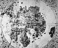
Structure
The map is circular with a diameter of 410mm. It is drawn on a piece of parchmentParchment
Parchment is a thin material made from calfskin, sheepskin or goatskin, often split. Its most common use was as a material for writing on, for documents, notes, or the pages of a book, codex or manuscript. It is distinct from leather in that parchment is limed but not tanned; therefore, it is very...
696x440 mm which also includes a calendar and two tables. One table was for calculating lunar changes, the other the date of Easter.
The map is oriented to the North, with a wind rose centered in Central Asia, possibly the observatory of Ulugh Begh in the Mongol city of Samarkand
Samarkand
Although a Persian-speaking region, it was not united politically with Iran most of the times between the disintegration of the Seleucid Empire and the Arab conquest . In the 6th century it was within the domain of the Turkic kingdom of the Göktürks.At the start of the 8th century Samarkand came...
in Uzbekistan
Uzbekistan
Uzbekistan , officially the Republic of Uzbekistan is a doubly landlocked country in Central Asia and one of the six independent Turkic states. It shares borders with Kazakhstan to the west and to the north, Kyrgyzstan and Tajikistan to the east, and Afghanistan and Turkmenistan to the south....
, or the western shore of the Caspian sea
Caspian Sea
The Caspian Sea is the largest enclosed body of water on Earth by area, variously classed as the world's largest lake or a full-fledged sea. The sea has a surface area of and a volume of...
. The wind rose divides the map into eight sectors.
The map is colored: the seas are left white, although the Red Sea
Red Sea
The Red Sea is a seawater inlet of the Indian Ocean, lying between Africa and Asia. The connection to the ocean is in the south through the Bab el Mandeb strait and the Gulf of Aden. In the north, there is the Sinai Peninsula, the Gulf of Aqaba, and the Gulf of Suez...
is colored in red. Continental land is colored in yellow, and several colors are used for islands. The mountains are in brown, the lakes are in blue, and rivers are in brown.
The extension shows a calendar with depictions of the signs of the zodiac
Zodiac
In astronomy, the zodiac is a circle of twelve 30° divisions of celestial longitude which are centred upon the ecliptic: the apparent path of the Sun across the celestial sphere over the course of the year...
and a table to calculate lunar positions.
The map is generally consistent with the Fra Mauro map
Fra Mauro map
The Fra Mauro map, "considered the greatest memorial of medieval cartography" according to Roberto Almagià, is a map made around 1450 by the Venetian monk Fra Mauro...
(1457), also drawn before the rounding of the Cape of Good Hope, and today visible in Venice.
Regions
The ocean surrounding the continental mass bears the mention "Mari Oziano Magno".Jerusalem is indicated (Jordan and Gorlan), although not at the exact center of the map. The three continents are rather clearly represented, and labeled "Europa", "Africa" and "Axia". The Indian Ocean
Indian Ocean
The Indian Ocean is the third largest of the world's oceanic divisions, covering approximately 20% of the water on the Earth's surface. It is bounded on the north by the Indian Subcontinent and Arabian Peninsula ; on the west by eastern Africa; on the east by Indochina, the Sunda Islands, and...
contains many colored islands, in a style reminiscent of Arab maps.
Atlantic Ocean
The CanariesCanary Islands
The Canary Islands , also known as the Canaries , is a Spanish archipelago located just off the northwest coast of mainland Africa, 100 km west of the border between Morocco and the Western Sahara. The Canaries are a Spanish autonomous community and an outermost region of the European Union...
and the Azores
Azores
The Archipelago of the Azores is composed of nine volcanic islands situated in the middle of the North Atlantic Ocean, and is located about west from Lisbon and about east from the east coast of North America. The islands, and their economic exclusion zone, form the Autonomous Region of the...
are depicted, showing an influence by Genoese and Catalan nautical maps.
Africa
Africa contains depictions of the Atlas mountainsAtlas Mountains
The Atlas Mountains is a mountain range across a northern stretch of Africa extending about through Morocco, Algeria, and Tunisia. The highest peak is Toubkal, with an elevation of in southwestern Morocco. The Atlas ranges separate the Mediterranean and Atlantic coastlines from the Sahara Desert...
and the Nile river, with mention of the territory of Prester John
Prester John
The legends of Prester John were popular in Europe from the 12th through the 17th centuries, and told of a Christian patriarch and king said to rule over a Christian nation lost amidst the Muslims and pagans in the Orient. Written accounts of this kingdom are variegated collections of medieval...
("Pre. Joanes") in Ethiopia
Ethiopia
Ethiopia , officially known as the Federal Democratic Republic of Ethiopia, is a country located in the Horn of Africa. It is the second-most populous nation in Africa, with over 82 million inhabitants, and the tenth-largest by area, occupying 1,100,000 km2...
.
The Garden of Eden
Garden of Eden
The Garden of Eden is in the Bible's Book of Genesis as being the place where the first man, Adam, and his wife, Eve, lived after they were created by God. Literally, the Bible speaks about a garden in Eden...
is depicted at the southernmost tip of Africa with the symbol of two concentric rings, from which emerge the four rivers mentioned in Genesis.
Asia
The locations described in Asia are consistent with MongolianMongols
Mongols ) are a Central-East Asian ethnic group that lives mainly in the countries of Mongolia, China, and Russia. In China, ethnic Mongols can be found mainly in the central north region of China such as Inner Mongolia...
rule: Medru, Calcar, Monza sede di sedre ("the Mangi of northern China"), and Bogar Tartarorum ("the Great Bulgarian" or "Golden Horde
Golden Horde
The Golden Horde was a Mongol and later Turkicized khanate that formed the north-western sector of the Mongol Empire...
"). On the emplacement of Karakorum
Karakorum
Karakorum was the capital of the Mongol Empire in the 13th century, and of the Northern Yuan in the 14-15th century. Its ruins lie in the northwestern corner of the Övörkhangai Province of Mongolia, near today's town of Kharkhorin, and adjacent to the Erdene Zuu monastery...
, fortifications are depicted, with the mention "M[on]gol". The names shown for Chinese rivers and cities are those used by Marco Polo
Marco Polo
Marco Polo was a Venetian merchant traveler from the Venetian Republic whose travels are recorded in Il Milione, a book which did much to introduce Europeans to Central Asia and China. He learned about trading whilst his father and uncle, Niccolò and Maffeo, travelled through Asia and apparently...
.
The shores of the Indian Ocean contain show the kingdoms of Mimdar and Madar (Malabar?) and probably Sri Lanka
Sri Lanka
Sri Lanka, officially the Democratic Socialist Republic of Sri Lanka is a country off the southern coast of the Indian subcontinent. Known until 1972 as Ceylon , Sri Lanka is an island surrounded by the Indian Ocean, the Gulf of Mannar and the Palk Strait, and lies in the vicinity of India and the...
with the mention "Ysola d alegro suczimcas magna". A large island in the Indian Ocean labelled "Caparu sive Java magna" possibly combines Marco Polo's descriptions of Java and Japan.
Europe
In northern Europe, various places are mentioned, such as "Ogama, Goga" Gog and MagogGog and Magog
Gog and Magog are names that appear primarily in various Jewish, Christian and Muslim scriptures, as well as numerous subsequent references in other works. Their context can be either genealogical or eschatological and apocalyptic, as in Ezekiel and Revelation...
, "Rotenia" Russia
Russia
Russia or , officially known as both Russia and the Russian Federation , is a country in northern Eurasia. It is a federal semi-presidential republic, comprising 83 federal subjects...
, Naia, Samolica, and a peninsua or promitory showing the southern end of "Norveca" Norway
Norway
Norway , officially the Kingdom of Norway, is a Nordic unitary constitutional monarchy whose territory comprises the western portion of the Scandinavian Peninsula, Jan Mayen, and the Arctic archipelago of Svalbard and Bouvet Island. Norway has a total area of and a population of about 4.9 million...
. Iceland/Thule is not named or shown on the map.
History of the map
The map was re-discovered in a second-hand bookshop in 1911 in ŠibenikŠibenik
Šibenik is a historic town in Croatia, with population of 51,553 . It is located in central Dalmatia where the river Krka flows into the Adriatic Sea...
, Croatia
Croatia
Croatia , officially the Republic of Croatia , is a unitary democratic parliamentary republic in Europe at the crossroads of the Mitteleuropa, the Balkans, and the Mediterranean. Its capital and largest city is Zagreb. The country is divided into 20 counties and the city of Zagreb. Croatia covers ...
by Albert Figdor, an art collector. Albert Figdor died 1927 in Vienna. The map was analysed by Doctor Professor Franz von Wieser, of the University of Vienna
University of Vienna
The University of Vienna is a public university located in Vienna, Austria. It was founded by Duke Rudolph IV in 1365 and is the oldest university in the German-speaking world...
. Authenticated photographs were taken, which are today in the British Library
British Library
The British Library is the national library of the United Kingdom, and is the world's largest library in terms of total number of items. The library is a major research library, holding over 150 million items from every country in the world, in virtually all known languages and in many formats,...
.
In literature, there are hints that the map was retracted from the auction (piece no. 56, 14/15.June 1932) by the auction-house Gilhofer and Ranschburg (Alpenstrasse nr.6) in Luzern. The story is not clear. The map later disappeared with its owners a Jewish family from Heidelberg
Heidelberg
-Early history:Between 600,000 and 200,000 years ago, "Heidelberg Man" died at nearby Mauer. His jaw bone was discovered in 1907; with scientific dating, his remains were determined to be the earliest evidence of human life in Europe. In the 5th century BC, a Celtic fortress of refuge and place of...
.