

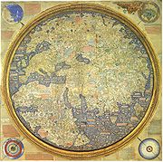
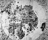
Fra Mauro map
Encyclopedia

Venice
Venice is a city in northern Italy which is renowned for the beauty of its setting, its architecture and its artworks. It is the capital of the Veneto region...
monk Fra Mauro
Fra Mauro
Fra Mauro, O.S.B. Cam., was a 15th-century Camaldolese monk who lived in the Republic of Venice. He was a monk of the Monastery of St. Michael, located on the island of Murano in the Venetian Lagoon. It was there that he maintained a cartography workshop.In his youth, Mauro had traveled...
. It is a circular planisphere
Planisphere
A planisphere is a star chart analog computing instrument in the form of two adjustable disks that rotate on a common pivot. It can be adjusted to display the visible stars for any time and date. It is an instrument to assist in learning how to recognize stars and constellations...
drawn on parchment
Parchment
Parchment is a thin material made from calfskin, sheepskin or goatskin, often split. Its most common use was as a material for writing on, for documents, notes, or the pages of a book, codex or manuscript. It is distinct from leather in that parchment is limed but not tanned; therefore, it is very...
and set in a wooden frame, about two meters in diameter.
A copy of the world map was made by Fra Mauro and his assistant Andrea Bianco, a sailor-cartographer, under a commission by king Afonso V of Portugal
Afonso V of Portugal
Afonso V KG , called the African , was the twelfth King of Portugal and the Algarves. His sobriquet refers to his conquests in Northern Africa.-Early life:...
. This copy was completed on April 24, 1459, and sent to Portugal
Portugal
Portugal , officially the Portuguese Republic is a country situated in southwestern Europe on the Iberian Peninsula. Portugal is the westernmost country of Europe, and is bordered by the Atlantic Ocean to the West and South and by Spain to the North and East. The Atlantic archipelagos of the...
, but did not survive to the present day.
The map was discovered in the monastery of San Michel in Isola, Murano
Murano
Murano is a series of islands linked by bridges in the Venetian Lagoon, northern Italy. It lies about 1.5 km north of Venice and measures about across with a population of just over 5,000 . It is famous for its glass making, particularly lampworking...
, where the Camaldolese cartographer had his studio, and is now located in a stairway in the Biblioteca Nazionale Marciana in Venice
Venice
Venice is a city in northern Italy which is renowned for the beauty of its setting, its architecture and its artworks. It is the capital of the Veneto region...
, but is visible by entering in the Museo Correr
Museo Correr
The Museo Correr is the civic museum of Venice, located in the Piazza San Marco, and is entered by the ceremonial stairway in the Ala Napoleonica at the western end of the Piazza opposite the church of San Marco at the other end...
, where it is accessible from the easternmost room upon request to the museum attendants there.
A number of historians of cartography, starting with Giacinto Placido Zurla
Giacinto Placido Zurla
Cardinal Placido Zurla, O.S.B. Cam., was an Italian Camaldolese monk and prelate, who was Cardinal Vicar of Rome and writer on medieval geography.-Biography:...
(1806) studied Fra Mauro's map. A critical edition of the map was edited by Piero Falchetta
Piero Falchetta
Piero Falchetta is head of the department of ancient maps at the Biblioteca Marciana in Venice and a specialist of medieval travel writing, history of cartography and history of navigation. He currently lives in his native Venice. One of his most recent contribution to medieval cartography is a...
in 2006.
World map
The Fra Mauro map is unusual, but typical of Fra Mauro's portolan chartPortolan chart
Portolan charts are navigational maps based on realistic descriptions of harbours and coasts. They were first made in the 14th century in Italy, Portugal and Spain...
s, in that its orientation is with the south at the top, one of the usual conventions of Muslim maps, in contrast with the Ptolemy map which has the north at the top. Fra Mauro was aware of the Ptolemy map, and commented that it was insufficient for many parts of the world:
"I do not think it derogatory to Ptolemy if I do not follow his Cosmografia, because, to have observed his meridians or parallels or degrees, it would be necessary in respect to the setting out of the known parts of this circumference, to leave out many provinces not mentioned by Ptolemy. But principally in latitude, that is from south to north, he has much 'terra incognita', because in his time it was unknown". (Text from Fra Mauro map)
He recognized however the extent of the East given by Ptolemy
Ptolemy
Claudius Ptolemy , was a Roman citizen of Egypt who wrote in Greek. He was a mathematician, astronomer, geographer, astrologer, and poet of a single epigram in the Greek Anthology. He lived in Egypt under Roman rule, and is believed to have been born in the town of Ptolemais Hermiou in the...
, thereby suppressing the central position that Jerusalem had held on previous maps:
"Jerusalem is indeed the center of the inhabited world latitudinally, though longitudinally it is somewhat to the west, but since the western portion is more thickly populated by reason of Europe, therefore Jerusalem is also the center longitudinally if we regard not empty space but the density of population". (Text from Fra Mauro map)
As was generally the case among Medieval scholars, Fra Mauro regarded the world as a sphere. However, he used the convention of describing the continents surrounded by water within the shape of a disc, but had no certainty about the size of the Earth:
"Likewise I have found various opinions regarding this circumference, but it is not possible to verify them. It is said to be 22,500 or 24,000 miglia or more, or less according to various considerations and opinions, but they are not of much authenticity, since they have not been tested". (Text from Fra Mauro map)
Although miglia is the Italian translation for miles, the modern mile was not standardized to be exactly 5,280 feet until 1592, so the intended estimation is somewhat ambiguous. Notably, the guess here only slightly underestimates the mean circumference of the Earth
Earth
Earth is the third planet from the Sun, and the densest and fifth-largest of the eight planets in the Solar System. It is also the largest of the Solar System's four terrestrial planets...
(approximately 24,880 miles). The depiction of inhabited places and mountains, the map's chorography
Chorography
Chorography is a term deriving from the writings of the ancient geographer Ptolemy, meaning the geographical description of regions...
is also an important feature. Castles and cities are identified by pictorial glyphs representing turreted castles or walled towns, distinguished in order of their importance.
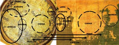
Africa

Africa
Africa is the world's second largest and second most populous continent, after Asia. At about 30.2 million km² including adjacent islands, it covers 6% of the Earth's total surface area and 20.4% of the total land area...
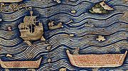
is reasonably accurate. Fra Mauro puts the following inscription by the southern tip of Africa, which he names the "Cape of Diab", describing the exploration by a ship from the East around 1420:
"Around 1420 a ship, or junk, from India crossed the Sea of India towards the Island of Men and the Island of Women, off Cape Diab, between the Green IslandsCape VerdeThe Republic of Cape Verde is an island country, spanning an archipelago of 10 islands located in the central Atlantic Ocean, 570 kilometres off the coast of Western Africa...
and the shadows. It sailed for 40 days in a south-westerly direction without ever finding anything other than wind and water. According to these people themselves, the ship went some 2,000 miles ahead until - once favourable conditions came to an end - it turned round and sailed back to Cape Diab in 70 days".
"The ships called junks (lit. "Zonchi") that navigate these seas carry four masts or more, some of which can be raised or lowered, and have 40 to 60 cabins for the merchants and only one tiller. They can navigate without a compass
CompassA compass is a navigational instrument that shows directions in a frame of reference that is stationary relative to the surface of the earth. The frame of reference defines the four cardinal directions – north, south, east, and west. Intermediate directions are also defined...
, because they have an astrologerAstrologerAn astrologer practices one or more forms of astrology. Typically an astrologer draws a horoscope for the time of an event, such as a person's birth, and interprets celestial points and their placements at the time of the event to better understand someone, determine the auspiciousness of an...
, who stands on the side and, with an astrolabeAstrolabeAn astrolabe is an elaborate inclinometer, historically used by astronomers, navigators, and astrologers. Its many uses include locating and predicting the positions of the Sun, Moon, planets, and stars, determining local time given local latitude and longitude, surveying, triangulation, and to...
in hand, gives orders to the navigator". (Text from the Fra Mauro map, 09-P25.)
Fra Mauro explained that he obtained the information from "a trustworthy source", who traveled with the expedition, possibly the Venetian explorer Niccolò da Conti
Niccolò Da Conti
Niccolò de' Conti was an Italian merchant and explorer of the Republic of Venice, born in Chioggia, who traveled to India and Southeast Asia, and possibly to Southern China, during the early 15th century...
who happened to be in Calicut, India
India
India , officially the Republic of India , is a country in South Asia. It is the seventh-largest country by geographical area, the second-most populous country with over 1.2 billion people, and the most populous democracy in the world...
at the time the expedition left:
"What is more, I have spoken with a person worthy of trust, who says that he sailed in an Indian ship caught in the fury of a tempest for 40 days out in the Sea of India, beyond the Cape of Soffala
SofalaSofala, at present known as Nova Sofala, used to be the chief seaport of the Monomotapa Kingdom, whose capital was at Mount Fura. It is located on the Sofala Bank in Sofala Province of Mozambique.-History:...
and the Green Islands towards west-southwest; and according to the astrologers who act as their guides, they had advanced almost 2,000 miles. Thus one can believe and confirm what is said by both these and those, and that they had therefore sailed 4,000 miles".
Some of the islands named in the area of the southern tip of Africa bear Arabian and Indian names: Nebila ("celebration" or "beautiful" in Arabic
Arabic language
Arabic is a name applied to the descendants of the Classical Arabic language of the 6th century AD, used most prominently in the Quran, the Islamic Holy Book...
), and Mangla ("fortunate" in Sanskrit
Sanskrit
Sanskrit , is a historical Indo-Aryan language and the primary liturgical language of Hinduism, Jainism and Buddhism.Buddhism: besides Pali, see Buddhist Hybrid Sanskrit Today, it is listed as one of the 22 scheduled languages of India and is an official language of the state of Uttarakhand...
.) These are normally identified as aforementioned "Islands of Men and Women". According to an old Arabian legend as retold by Marco Polo
Marco Polo
Marco Polo was a Venetian merchant traveler from the Venetian Republic whose travels are recorded in Il Milione, a book which did much to introduce Europeans to Central Asia and China. He learned about trading whilst his father and uncle, Niccolò and Maffeo, travelled through Asia and apparently...
, one of these islands was populated exclusively by men and the other was populated exclusively by women, and the two would only meet for conjugal relations once a year. Their location was not certain and the location proposed by Fra Mauro is but one of multiple possibilities: Marco Polo himself located them in the neighborhood of Socotra
Socotra
Socotra , also spelt Soqotra, is a small archipelago of four islands in the Indian Ocean. The largest island, also called Socotra, is about 95% of the landmass of the archipelago. It lies some east of the Horn of Africa and south of the Arabian Peninsula. The island is very isolated and through...
, and other medieval cartographers offered locations in Southeast Asia, near Singapore
Singapore
Singapore , officially the Republic of Singapore, is a Southeast Asian city-state off the southern tip of the Malay Peninsula, north of the equator. An island country made up of 63 islands, it is separated from Malaysia by the Straits of Johor to its north and from Indonesia's Riau Islands by the...
or in the Philippines
Philippines
The Philippines , officially known as the Republic of the Philippines , is a country in Southeast Asia in the western Pacific Ocean. To its north across the Luzon Strait lies Taiwan. West across the South China Sea sits Vietnam...
. It is generally thought that the islands are mythical.
Fra Mauro also comments that the account of this expedition, together with the relation by Strabo
Strabo
Strabo, also written Strabon was a Greek historian, geographer and philosopher.-Life:Strabo was born to an affluent family from Amaseia in Pontus , a city which he said was situated the approximate equivalent of 75 km from the Black Sea...
of the travels of Eudoxus of Cyzicus
Eudoxus of Cyzicus
Eudoxus of Cyzicus was a Greek navigator who explored the Arabian Sea for Ptolemy VIII, king of the Hellenistic Ptolemaic dynasty in Egypt.-Voyages to India:...
from Arabia to Gibraltar
Gibraltar
Gibraltar is a British overseas territory located on the southern end of the Iberian Peninsula at the entrance of the Mediterranean. A peninsula with an area of , it has a northern border with Andalusia, Spain. The Rock of Gibraltar is the major landmark of the region...
through the southern Ocean in Antiquity
Classical antiquity
Classical antiquity is a broad term for a long period of cultural history centered on the Mediterranean Sea, comprising the interlocking civilizations of ancient Greece and ancient Rome, collectively known as the Greco-Roman world...
, led him to believe that the Indian Ocean
Indian Ocean
The Indian Ocean is the third largest of the world's oceanic divisions, covering approximately 20% of the water on the Earth's surface. It is bounded on the north by the Indian Subcontinent and Arabian Peninsula ; on the west by eastern Africa; on the east by Indochina, the Sunda Islands, and...
was not a closed sea and that Africa
Africa
Africa is the world's second largest and second most populous continent, after Asia. At about 30.2 million km² including adjacent islands, it covers 6% of the Earth's total surface area and 20.4% of the total land area...
could be circumnavigated by her southern end (Text from Fra Mauro map, 11,G2). This knowledge, together with the map depiction of the African continent, probably encouraged the Portuguese to intensify their effort to round the tip of Africa.
Japan
The Fra Mauro map is one of the first Western maps to represent the islands of Japan (possibly after the De Virga world mapDe Virga world map
The De Virga world map was made by Albertinus de Virga between 1411 and 1415. The map contains a mention in small letters:Albertinus de Virga, a Venetian, is also known for a 1409 map of the Mediterranean, also made in Venice.-Structure:...
). A part of Japan, probably Kyūshū
Kyushu
is the third largest island of Japan and most southwesterly of its four main islands. Its alternate ancient names include , , and . The historical regional name is referred to Kyushu and its surrounding islands....
, appears below the island of Java, with the legend "Isola de Cimpagu" (a mis-spelling of Cipangu).
Origins
Piero Falchetta
Piero Falchetta is head of the department of ancient maps at the Biblioteca Marciana in Venice and a specialist of medieval travel writing, history of cartography and history of navigation. He currently lives in his native Venice. One of his most recent contribution to medieval cartography is a...
notes, there are many geographical facts reflected in Fra Mauro map for which it is not clear what Fra Mauro's source was, as no similar information is found in other preserved Western maps or manuscripts of the period. This situation can be at least partially explained by the fact that, besides the existing maps and manuscripts, an important source of information for his map were oral accounts from travelers - Venetians or foreigners - coming to Venice from all parts of the then-known world. The importance of such accounts is indicated by Fra Mauro himself in a number of inscriptions. An even earlier map, the De Virga world map
De Virga world map
The De Virga world map was made by Albertinus de Virga between 1411 and 1415. The map contains a mention in small letters:Albertinus de Virga, a Venetian, is also known for a 1409 map of the Mediterranean, also made in Venice.-Structure:...
(1411-1415) also depicts the old world in a way broadly similar to the Fra Mauro map, and may have contributed to it.
The book of travels of Marco Polo
Marco Polo
Marco Polo was a Venetian merchant traveler from the Venetian Republic whose travels are recorded in Il Milione, a book which did much to introduce Europeans to Central Asia and China. He learned about trading whilst his father and uncle, Niccolò and Maffeo, travelled through Asia and apparently...
is believed to be one of the most important sources of information, in particular about the East Asia
East Asia
East Asia or Eastern Asia is a subregion of Asia that can be defined in either geographical or cultural terms...
. Fra Mauro also probably relied on Arab sources. This is suggested by the North-South inversion of the map, an Arab tradition exemplified by the 12th century maps of Muhammad al-Idrisi
Muhammad al-Idrisi
Abu Abd Allah Muhammad al-Idrisi al-Qurtubi al-Hasani al-Sabti or simply Al Idrisi was a Moroccan Muslim geographer, cartographer, Egyptologist and traveller who lived in Sicily, at the court of King Roger II. Muhammed al-Idrisi was born in Ceuta then belonging to the Almoravid Empire and died in...
, and the detailed information on the southeastern coast of Africa, which was brought by an Ethiopian embassy to Rome in the 1430s.
See also
- Ancient world mapsAncient world mapsEarly world maps cover depictions of the world from the Iron Age to the Age of Discovery and the emergence of modern geography during the early modern period.-Babylonian Imago Mundi Early world maps cover depictions of the world from the Iron Age to the Age of Discovery and the emergence of modern...
- Age of DiscoveryAge of DiscoveryThe Age of Discovery, also known as the Age of Exploration and the Great Navigations , was a period in history starting in the early 15th century and continuing into the early 17th century during which Europeans engaged in intensive exploration of the world, establishing direct contacts with...
External links
- Fra Mauro, c.1450 1804 copy in the British Library. Deep zoom feature, highlighted details. Video introduction from Curator of Antiquarian Mapping
- Monograph on Fra Mauro's map
- Compilation of the text on Fra Mauro's map (Italian).