

Cyclone Thelma
Encyclopedia
Severe Tropical Cyclone Thelma was a tropical cyclone
that affected northern Australia
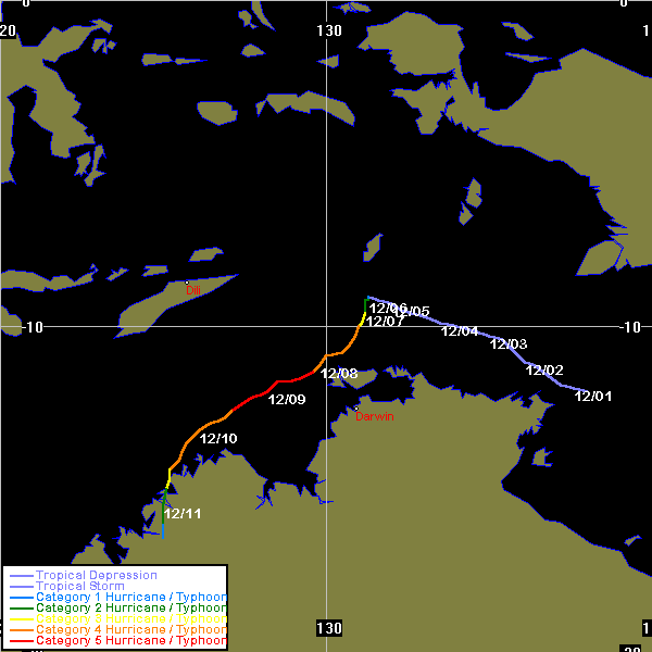
from 6 December 1998 until 12 December 1998. Cyclone Thelma was one of the most intense tropical cyclones to be observed off the coast of Australia. Thelma formed in the Arafura Sea
north of the Northern Territory
while intensifying rapidly into a Category 5 cyclone, passing very near the Tiwi Islands
and posing a severe threat to Darwin
, but fortunately passed by at a distance of 200 km (124.3 mi). It then moved across the Timor Sea
before hitting the north Kimberley
coast. Thelma was the first known Category 5 cyclone to be observed in the Timor Sea
, and was also the most intense cyclone to threaten Darwin since Cyclone Tracy
on Christmas Eve in 1974. Ten months after the storm's passage, the skull of an 81-year-old man, who was believed to have been swept away by flood waters, was discovered.
(0430 UTC
) on 6 December, located about 350 km (217.5 mi) north of Darwin
. The new cyclone drifted slowly south while rapidly intensifying. Thelma's intensity increased from a Category 2 to a Category 4 during 7 December. Thelma turned towards the southwest and reached Category 5 intensity on the Australian scale just north of Bathurst Island
at about 9 a.m. CST on 8 December (2330 UTC 7 December). The cyclone attained a minimum central pressure of 920 hPa
, and maximum wind gusts of 320 km/h (200 mph) at 8 p.m. CST (1030 UTC) on the 8 December, only two days after being named. Cyclone Thelma's rate of intensification was close to twice the average rate of most cyclones.
Thelma continued moving steadily southwest at about 10 km/h (6 mph) before turning southwards, passing about 50 km (31.1 mi) from Troughton Island. The cyclone weakened to a Category 3 while crossing the Kimberley
coast northwest of Kuri Bay
early on 11 December. The cyclone weakened rapidly while over land. Thelma was downgraded below cyclone strength late on 11 December while moving in a more southerly track. The ex-cyclone moved through the west Kimberley and Pilbara
on 12 December and 13 December. On the morning of 14 December, the low crossed the Pilbara coast north of Wallal
, 240 km (149.1 mi) east northeast of Port Hedland
. It then moved southward through Pilbara and dissipated.
, and offshore installations directly affected by the cyclone were either evacuated or were sheltered in secure accommodation. The port of Darwin was closed during the cyclone, schools were closed for one day and public cyclone shelters were opened on the night of 8 December for people who felt insecure in their place of residence. Emergency officials evacuated about 120 people in the tiny community of Kalumburu
, but about 180 people were left behind. Most of those sheltered in an old monastery which had 60 cm (24 in) thick stone walls.
and the Kimberley coast.
In the Tiwi Islands
, the most significant impact was disruption to communications and power supplies. The telephone service throughout the Tiwi Islands was shut down for over 24 hours. The radio and television reception was interrupted by heavy rain and lightning, and the power supply in Pirlangimpi (Garden Point) was cut by fallen trees. Around Bathurst Island
and northwest Melville Island, there was extensive damage to vegetation in exposed areas. Minor coastal erosion occurred in Milikapiti, where waves rose up to 4 metres (13 ft) above water level. In Pirlangimpi, many large trees were uprooted and several houses were slightly damaged. In Nguiu, Bathurst Island Township, some trees were blown down but there was no significant damage.
In Darwin
, there was minor damage to houses and minor disruption to power supplies, caused by falling trees. A record 425 mm (16.7 in) of rain was recorded within 24 hours at Howard Springs
, and a 48 hour total of 432 mm (17 in) was recorded at Darwin Airport from 8 December to 10 December. The rain caused local flooding in the rural areas around Darwin, blocking off some areas.
In the Kimberley region
, there was minor damage to some buildings at Kalumburu and water level in the river rose to within 50 metres (165 ft) of the town. The BHP facilities at Troughton Island were affected by very destructive winds and heavy rainfall from the cyclone's core, damaging the runway and buildings. Average wind speeds of 139 km/h (86 mph) and a maximum gust of 174 km/h (108 mph) were recorded before communications were lost. Only minor damage was received at the pearling facilities at Vansittart Bay and Kuri Bay, mainly to floating pontoons. A number of places reported daily rainfall totals in excess of 100 mm (3.9 inches) including 223 mm (8.78 in) in Kalumburu on 11 December, and 174 mm (6.85 in) in Ellendake on 13 December. McGowan Island, to the north of Kalumburu
received 490 mm (19.3 in) of rain between 9 December and 13 December. Parts of east Pilbara also reported heavy rains over several days. Marble Bar
recorded 239 mm (9.4 in) and Newman
recorded 175 mm (6.89 in) in a two day period.
. It was replaced with the name Tasha.
Tropical cyclone
A tropical cyclone is a storm system characterized by a large low-pressure center and numerous thunderstorms that produce strong winds and heavy rain. Tropical cyclones strengthen when water evaporated from the ocean is released as the saturated air rises, resulting in condensation of water vapor...
that affected northern Australia
Australia
Australia , officially the Commonwealth of Australia, is a country in the Southern Hemisphere comprising the mainland of the Australian continent, the island of Tasmania, and numerous smaller islands in the Indian and Pacific Oceans. It is the world's sixth-largest country by total area...
from 6 December 1998 until 12 December 1998. Cyclone Thelma was one of the most intense tropical cyclones to be observed off the coast of Australia. Thelma formed in the Arafura Sea
Arafura Sea
The Arafura Sea lies west of the Pacific Ocean overlying the continental shelf between Australia and New Guinea.-Geography:The Arafura Sea is bordered by Torres Strait and through that the Coral Sea to the east, the Gulf of Carpentaria to the south, the Timor Sea to the west and the Banda and Ceram...
north of the Northern Territory
Northern Territory
The Northern Territory is a federal territory of Australia, occupying much of the centre of the mainland continent, as well as the central northern regions...
while intensifying rapidly into a Category 5 cyclone, passing very near the Tiwi Islands
Tiwi Islands
The Tiwi Islands are part of Australia's Northern Territory, north of Darwin where the Arafura Sea joins the Timor Sea. They comprise Melville Island and Bathurst Island, with a combined area of ....
and posing a severe threat to Darwin
Darwin, Northern Territory
Darwin is the capital city of the Northern Territory, Australia. Situated on the Timor Sea, Darwin has a population of 127,500, making it by far the largest and most populated city in the sparsely populated Northern Territory, but the least populous of all Australia's capital cities...
, but fortunately passed by at a distance of 200 km (124.3 mi). It then moved across the Timor Sea
Timor Sea
The Timor Sea is a relatively shallow sea bounded to the north by the island of Timor, to the east by the Arafura Sea, to the south by Australia and to the west by the Indian Ocean....
before hitting the north Kimberley
Kimberley region of Western Australia
The Kimberley is one of the nine regions of Western Australia. It is located in the northern part of Western Australia, bordered on the west by the Indian Ocean, on the north by the Timor Sea, on the south by the Great Sandy and Tanami Deserts, and on the east by the Northern Territory.The region...
coast. Thelma was the first known Category 5 cyclone to be observed in the Timor Sea
Timor Sea
The Timor Sea is a relatively shallow sea bounded to the north by the island of Timor, to the east by the Arafura Sea, to the south by Australia and to the west by the Indian Ocean....
, and was also the most intense cyclone to threaten Darwin since Cyclone Tracy
Cyclone Tracy
Cyclone Tracy was a tropical cyclone that devastated the city of Darwin, Northern Territory, Australia, from Christmas Eve to Christmas Day, 1974...
on Christmas Eve in 1974. Ten months after the storm's passage, the skull of an 81-year-old man, who was believed to have been swept away by flood waters, was discovered.
Meteorological history
A developing low in the Timor Sea in early December was named Thelma at 2 p.m. Australian Central Standard TimeTime in Australia
Australia uses Standard time, i.e: the same well defined time for a region. The proper names of Australia's time zones are Australian Western Standard Time , Australian Central Standard Time , and Australian Eastern Standard Time...
(0430 UTC
Coordinated Universal Time
Coordinated Universal Time is the primary time standard by which the world regulates clocks and time. It is one of several closely related successors to Greenwich Mean Time. Computer servers, online services and other entities that rely on having a universally accepted time use UTC for that purpose...
) on 6 December, located about 350 km (217.5 mi) north of Darwin
Darwin, Northern Territory
Darwin is the capital city of the Northern Territory, Australia. Situated on the Timor Sea, Darwin has a population of 127,500, making it by far the largest and most populated city in the sparsely populated Northern Territory, but the least populous of all Australia's capital cities...
. The new cyclone drifted slowly south while rapidly intensifying. Thelma's intensity increased from a Category 2 to a Category 4 during 7 December. Thelma turned towards the southwest and reached Category 5 intensity on the Australian scale just north of Bathurst Island
Bathurst Island, Northern Territory
Bathurst Island is one of the Tiwi Islands in the Northern Territory off the northern coast of Australia along with Melville Island.-Description:...
at about 9 a.m. CST on 8 December (2330 UTC 7 December). The cyclone attained a minimum central pressure of 920 hPa
Pascal (unit)
The pascal is the SI derived unit of pressure, internal pressure, stress, Young's modulus and tensile strength, named after the French mathematician, physicist, inventor, writer, and philosopher Blaise Pascal. It is a measure of force per unit area, defined as one newton per square metre...
, and maximum wind gusts of 320 km/h (200 mph) at 8 p.m. CST (1030 UTC) on the 8 December, only two days after being named. Cyclone Thelma's rate of intensification was close to twice the average rate of most cyclones.
Thelma continued moving steadily southwest at about 10 km/h (6 mph) before turning southwards, passing about 50 km (31.1 mi) from Troughton Island. The cyclone weakened to a Category 3 while crossing the Kimberley
Kimberley region of Western Australia
The Kimberley is one of the nine regions of Western Australia. It is located in the northern part of Western Australia, bordered on the west by the Indian Ocean, on the north by the Timor Sea, on the south by the Great Sandy and Tanami Deserts, and on the east by the Northern Territory.The region...
coast northwest of Kuri Bay
Kuri Bay
Kuri Bay is a remote coastal bay in the far north of Western Australia in the Kimberley region, about north of Broome. The closest main town is Derby that is located southwest from the bay. The bay opens directly into the Indian Ocean and the Augustus Island is located just off-shore from the bay...
early on 11 December. The cyclone weakened rapidly while over land. Thelma was downgraded below cyclone strength late on 11 December while moving in a more southerly track. The ex-cyclone moved through the west Kimberley and Pilbara
Pilbara region of Western Australia
The Pilbara is a large, dry, thinly populated region in the north of Western Australia known for its vast mineral deposits, in particular iron ore...
on 12 December and 13 December. On the morning of 14 December, the low crossed the Pilbara coast north of Wallal
Wallal
Wallal is the location of a bore in the Kimberley region of Western Australia.The bore is located from the Great Northern Highway between Port Hedland and Broome and has an elevation of . The nearest town is Marble Bar which is situated South of the bore....
, 240 km (149.1 mi) east northeast of Port Hedland
Port Hedland, Western Australia
Port Hedland is the highest tonnage port in Australia and largest town in the Pilbara region of Western Australia, with a population of approximately 14,000 ....
. It then moved southward through Pilbara and dissipated.
Preparations
All residents of major communities including DarwinDarwin, Northern Territory
Darwin is the capital city of the Northern Territory, Australia. Situated on the Timor Sea, Darwin has a population of 127,500, making it by far the largest and most populated city in the sparsely populated Northern Territory, but the least populous of all Australia's capital cities...
, and offshore installations directly affected by the cyclone were either evacuated or were sheltered in secure accommodation. The port of Darwin was closed during the cyclone, schools were closed for one day and public cyclone shelters were opened on the night of 8 December for people who felt insecure in their place of residence. Emergency officials evacuated about 120 people in the tiny community of Kalumburu
Kalumburu, Western Australia
Kalumburu and Kalumburu Community are both bounded localities within the Shire of Wyndham-East Kimberley Western Australia. Kalumburu Community is the northernmost settlement in Western Australia...
, but about 180 people were left behind. Most of those sheltered in an old monastery which had 60 cm (24 in) thick stone walls.
Impact
Overall, the damage caused by Cyclone Thelma was relatively light, compared with the cyclone's severe intensity. However, Thelma still had a significant impact on people's activities near the Tiwi IslandsTiwi Islands
The Tiwi Islands are part of Australia's Northern Territory, north of Darwin where the Arafura Sea joins the Timor Sea. They comprise Melville Island and Bathurst Island, with a combined area of ....
and the Kimberley coast.
In the Tiwi Islands
Tiwi Islands
The Tiwi Islands are part of Australia's Northern Territory, north of Darwin where the Arafura Sea joins the Timor Sea. They comprise Melville Island and Bathurst Island, with a combined area of ....
, the most significant impact was disruption to communications and power supplies. The telephone service throughout the Tiwi Islands was shut down for over 24 hours. The radio and television reception was interrupted by heavy rain and lightning, and the power supply in Pirlangimpi (Garden Point) was cut by fallen trees. Around Bathurst Island
Bathurst Island, Northern Territory
Bathurst Island is one of the Tiwi Islands in the Northern Territory off the northern coast of Australia along with Melville Island.-Description:...
and northwest Melville Island, there was extensive damage to vegetation in exposed areas. Minor coastal erosion occurred in Milikapiti, where waves rose up to 4 metres (13 ft) above water level. In Pirlangimpi, many large trees were uprooted and several houses were slightly damaged. In Nguiu, Bathurst Island Township, some trees were blown down but there was no significant damage.
In Darwin
Darwin, Northern Territory
Darwin is the capital city of the Northern Territory, Australia. Situated on the Timor Sea, Darwin has a population of 127,500, making it by far the largest and most populated city in the sparsely populated Northern Territory, but the least populous of all Australia's capital cities...
, there was minor damage to houses and minor disruption to power supplies, caused by falling trees. A record 425 mm (16.7 in) of rain was recorded within 24 hours at Howard Springs
Howard Springs, Northern Territory
Howard Springs is an outer rural area of Darwin. It is 29km SE of the Darwin CBD. Its Local Government Area is the Litchfield Municipality. The suburb is mostly a rural area, but has been experiencing strong growth in population and development. Settlement of the suburb began in 1864. In 1939,...
, and a 48 hour total of 432 mm (17 in) was recorded at Darwin Airport from 8 December to 10 December. The rain caused local flooding in the rural areas around Darwin, blocking off some areas.
In the Kimberley region
Kimberley region of Western Australia
The Kimberley is one of the nine regions of Western Australia. It is located in the northern part of Western Australia, bordered on the west by the Indian Ocean, on the north by the Timor Sea, on the south by the Great Sandy and Tanami Deserts, and on the east by the Northern Territory.The region...
, there was minor damage to some buildings at Kalumburu and water level in the river rose to within 50 metres (165 ft) of the town. The BHP facilities at Troughton Island were affected by very destructive winds and heavy rainfall from the cyclone's core, damaging the runway and buildings. Average wind speeds of 139 km/h (86 mph) and a maximum gust of 174 km/h (108 mph) were recorded before communications were lost. Only minor damage was received at the pearling facilities at Vansittart Bay and Kuri Bay, mainly to floating pontoons. A number of places reported daily rainfall totals in excess of 100 mm (3.9 inches) including 223 mm (8.78 in) in Kalumburu on 11 December, and 174 mm (6.85 in) in Ellendake on 13 December. McGowan Island, to the north of Kalumburu
Kalumburu, Western Australia
Kalumburu and Kalumburu Community are both bounded localities within the Shire of Wyndham-East Kimberley Western Australia. Kalumburu Community is the northernmost settlement in Western Australia...
received 490 mm (19.3 in) of rain between 9 December and 13 December. Parts of east Pilbara also reported heavy rains over several days. Marble Bar
Marble Bar, Western Australia
-North Pole:An ironically named locality nearby is known as North Pole , no doubt for its heat. It is the location of rock formations considered to have evidence that puts the origin of life on earth back to 3,400–3,500 mya, due to stromatolites in particular rock sequences...
recorded 239 mm (9.4 in) and Newman
Newman, Western Australia
Newman, located about 1186 km north of Perth and 9 km north of the Tropic of Capricorn, is a town in the Pilbara region. It can be reached by the Great Northern Highway...
recorded 175 mm (6.89 in) in a two day period.
Retirement
The name Thelma was removed from the official list of tropical cyclone names set out by the Tropical Cyclone Warning Centre in DarwinDarwin, Northern Territory
Darwin is the capital city of the Northern Territory, Australia. Situated on the Timor Sea, Darwin has a population of 127,500, making it by far the largest and most populated city in the sparsely populated Northern Territory, but the least populous of all Australia's capital cities...
. It was replaced with the name Tasha.