
Kimberley region of Western Australia
Encyclopedia
The Kimberley is one of the nine regions of Western Australia
. It is located in the northern part of Western Australia
, bordered on the west by the Indian Ocean
, on the north by the Timor Sea
, on the south by the Great Sandy
and Tanami Desert
s, and on the east by the Northern Territory
.
The region was named after the Kimberley
diamond fields in South Africa. This was due to the two areas sharing a similar landscape. The discovery of diamonds in the Kimberley region has subsequently added to the likeness.
.
In 1837, with support from the Royal Geographical Society
, Lieutenants George Grey
and Franklin Lushington, and 12 men sailed on the schooner Lynher from Cape Town
reaching Hanover Bay on 2 December 1837. The party started inland on 19 January 1838. Leaders and men were totally inexperienced, progress was delayed by flooded country, many stores were abandoned, and the party was constantly split up despite the presence of large numbers of hostile Aboriginals. On 11 February Grey was speared and became critically ill, but after two weeks continued the exploration. The party discovered and named the Glenelg River
, Stephen Range and Mount Lyell
before returning to Hanover Bay in April. There they were picked up by the Beagle
and Lynher and taken to Mauritius to recuperate.
In 1879 Alexander Forrest
trekked across from the western coast to the Northern Territory
. Forrest named the Kimberley district, and discovered the Margaret and Ord Rivers, the King Leopold Ranges, and the fertile area between the Fitzroy
and Ord River
. He subsequently set himself up as a land agent specialising in the Kimberley and was thus instrumental in the leasing of over 51000000 acres (206,389.9 km²) in the region during 1883.
In 1881, Philip Saunders and Adam Johns, in the face of great difficulties and dangers found gold in various parts of the Kimberley. Early in 1881 the first five graziers, who called themselves the Murray Squatting Company, took up 120,000 behind Beagle Bay and named it Yeeda Station. They became the first men to shear sheep in the southern Kimberley in 1883. There was further European settlement in 1885, when cattle were driven across Australia from the eastern states in search of good pasture
lands. Many other Europeans arrived soon after, when gold was discovered around Halls Creek
.
In the 1890's the area was the site of an armed insurrection of indigenous people under the leadership of Jandamarra
, a Bunuba warrior.
The only Japanese force to land in Australia during World War II
was a small reconnaissance party that landed in the Kimberley on 19 January 1944 to investigate reports that the Allies were building large bases in the region. The party consisted of four Japanese officers on board a small fishing boat. It investigated the York Sound
region for a day and a night before returning to Kupang in Timor
on 20 January. Upon returning to Japan in February, the junior officer who commanded the party suggested using 200 Japanese prison inmates to launch a guerrilla campaign in Australia. Nothing came of this and the officer was posted to other duties.
The population of the Kimberley is only about 41,000, but this figure is growing at a rate of 4.8% per year, around three times the state average. The population is fairly evenly distributed, with only three towns having populations in excess of 2,000: Broome
(15,000), Derby
(3,600) and Kununurra (5,000). Approximately 33% of the region's population are of Aboriginal
descent.
. At state level, the Kimberley
electorate takes in most of the region and all of its major towns, while Pilbara includes south-eastern areas such as Halls Creek
and Fitzroy Crossing
.
The Kimberley region consists of the local government areas
of Broome
, Derby-West Kimberley, Halls Creek
and Wyndham-East Kimberley.
 The Kimberley is an area of 423517 square kilometres (163,521 sq mi), which is about three times the size of England
or twice the size of Victoria
.
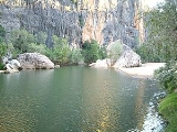
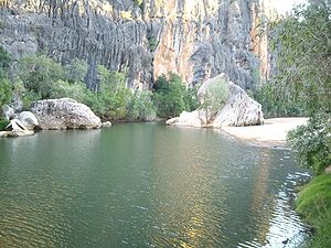
The Kimberley consists of the ancient, steep-sided mountain ranges of northwestern Australia cut through with sandstone and limestone gorges and steep ridges from which the extreme monsoonal climate has removed much of the soil. The southern end of the Kimberley beyond the Dampier Peninsula
is flatter with dry tropical grassland and is used for cattle ranching. In parts of the Kimberley such as the valleys of the Ord
and Fitzroy River
s in the south the soils are relatively usable cracking clays
, whilst elsewhere they are lateritic
Orthent
s. Although none of the mountains reach even 1000 metres (3,281 ft), there is so much steep land as to make much of the region very difficult to traverse, especially during the wet season when even sealed roads are often flooded. The coast is typically steep cliffs in the north but flatter in the south, all subject to high tides.
The Kimberley has a tropical monsoon
climate. The region receives about 90% of its rainfall during the short wet season, from November to April, when cyclones
are common (especially around Broome) and the rivers flood. The annual rainfall is highest in the northwest, where Kalumburu and the Mitchell Plateau
average 1270 millimetres (50 in) per year, and lowest in the southeast where it is around 520 millimetres (20 in). In the dry season, from May to October, south easterly breezes bring sunny days and cool nights. Climate change
since 1967 has led to large increases of as much as 250 millimetres (10 in) per year in annual rainfall over the whole region. Recent studies suggest Asian pollution
and not global warming
as the cause of this increased rainfall. In 1997 and 2000 the region received especially heavy rains, leading to record flooding of the Fitzroy and other rivers.
The Kimberley is one of the hottest parts of Australia, with the average annual mean temperature around 27 °C (81 °F), and with mean maximum temperatures almost always above 30 °C (86 °F) even in July and ranging in November before the rains break from 37 °C (99 °F) on the coast to 40 °C (104 °F) in the south around Halls Creek. Mean minima in July range from around 12 °C (54 °F) in the south to 16 °C (60.8 °F) around Kalumburu, whilst in November and December they are generally around 26 °C (79 °F).
The aboriginal people of the Kimberley recognise 6 traditional seasons based on meteorological events as well as observed events relating to fauna and flora.
period, a barrier reef system formed before a subsequent drop in sea levels over the Kimberley. This reef system was similar to the Great Barrier Reef
and is still visible today in the form of the Napier Range
and the Ningbing Range. Some of the features are Tunnel Creek
, Windjana Gorge
and Geikie Gorge
.
This area is also known as the Kimberly Block physiographic province, of which it is part of the larger West Australian Shield
division. This province contains the King Leopold Range, Durack Range, Leveque Rise, Browse Depression, and Londonderry Rise physiographic sections.The Aboriginals used this to their advantage.
including the valleys of the Victoria and Daly River
s but these have been less carefully studied.
woodland dominated by low bloodwood
and boab trees (Adansonia gregorii) with Darwin stringybark and Darwin woollybutt
eucalypts in the wetter areas. The red sandy soil of the Dampier Peninsula
in the south is known for its characteristic pindan
wooded grassland while in the more fertile areas like the Ord valley the trees are grasslands of Chrysopogon
, Aristida, Dicanthium and Xerochloa
(rice grass) in the wetter valleys. The banks of the Ord
, Fitzroy and other rivers are home to a greater variety of vegetation while in sheltered gorges of the high rainfall north there are patches of tropical dry broadleaf forest, called monsoon forests, deciduous vine forest or vine thicket in Australia (often mistakenly called 'dry rainforest'), which were unknown to science until 1965 and are one of the most floristically rich parts of Australia outside the Wet Tropics and southwestern WA. There are also areas of mangrove
in river estuaries where the coast is flatter.
and a rich variety of birds such as the Channel-billed Cuckoo
, Pacific Koel
, and Purple-crowned Fairywren. The sandstone gorges of north Kimberley are an important refuge for a particularly rich collection of endemic species including some that have disappeared from the flatter areas including for example the purple-crowned fairywren, the endangered Gouldian Finch
and a large number of frogs: Flat-headed Frog, Cave-dwelling Frog, Magnificent Tree Frog, Derby Toadlet, Small Toadlet, Fat Toadlet, the unconfirmed Marbled Toadlet, Mjoberg's Toadlet, Mole Toadlet and Stonemason's Toadlet. Mammals that have declined especially in the flatlands include the bilby
, Northern Quoll
, Pale Field Rat
, Golden-Backed Tree Rat
, and Golden Bandicoot
.
The gorges of central Kimberley known for their fossils and for their large colonies of bats include Windjana
, Tunnel Creek
, and Geikie Gorge
s. Lake Argyle
and other wetlands of the Ord and the Kimberley are important habitats while there are important populations of shorebirds in the Ord estuary, Eighty-mile Beach and Roebuck Bay
, which has been described as "one of the most important stop-over areas for shorebirds in Australia and globally". Finally there are a number of rocky islands off the north coast that are home to birds and turtles.
, parkinsonia
, bellyache bush and castor oil plant
), feral cats and changes to traditional Aboriginal fire regime
s (the way grassland is burnt and allowed to renew). However the remote sandstone areas to the north have valuable original habitat in good condition providing shelter for much wildlife.
The largest protected areas are the Prince Regent Nature Reserve
and the Drysdale River National Park
along with Gregory National Park
and Keep River National Park
across in the Northern Territory which preserve similar habitats, (and indeed Keep River's nearest town is Kununurra in the Kimberley).
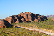 The Kimberley is a popular tourist destination, with areas such as the Bungle Bungle, the Gibb River Road
, Lake Argyle
, El Questro Station, Horizontal Falls
and Cape Leveque
. The Gibb River Road and the road into the Bungle Bungles can at times be accessed in a two-wheel drive
car, although one can access many additional areas in a four-wheel drive
vehicle.
Other parks in the region include Geikie Gorge National Park
, Mirima National Park, Mitchell River National Park
, Point Coulomb National Park, Purnululu National Park
, Tunnel Creek National Park
, Windjana Gorge National Park
and Wolfe Creek Meteorite Crater National Park
One third of the world's annual production of diamonds is mined at the Argyle
and the Ellendale diamond
mines. Oil
is extracted from the Blina oil field and gas
is expected to be taken from offshore sources soon. Zinc
and lead
were mined at the Pillara and Cadjebut mines near Fitzroy Crossing with Nickel still being mined at Sallay Mallay near Halls Creek. Derby is the nearest export base for shipping these metals.
Traditionally, the economy depended on pastoral leases - with most of the region covered by the leases.
More recently agriculture has been focused on the Ord River
Irrigation Area near Kununurra
. Irrigation was also trialled in the West Kimberley by way of the now defunct Camballin Irrigation Scheme
. There are also fruit growers in Broome
and in other areas in the West Kimberley. Beef cattle are grown in the Kimberley and exported live. Wyndham features the last remaining meatworks in the Kimberley - there were formerly works at Broome and Derby but financial constraints have caused these to be closed.
Barramundi
are bred in Lake Argyle
; and Broome features a fully equipped Aquaculture Park near the port which is tenanted by amongst others Paspaley Pearls and Broome TAFE. The Kimberley also has a thriving fishing industry.
Some of Australia's most prominent indigenous artists and art centres are in or adjacent to the Kimberley region. Artists such as Paddy Bedford
and Freddy Timms
have an international profile, and there are a number of Aboriginal-owned and controlled art centres and companies that assist artists, arrange exhibitions and sell works. The art centres in the region are also organised through the Association of Northern, Kimberley and Arnhem Aboriginal Artists. Issues have been raised regarding the exploitation of indigenous artists by businesses and individuals, including in the Kimberley, which were canvassed in an Australian Senate
parliamentary committee report.
Regions of Western Australia
Regionalisations of Western Australia are systems by which Western Australia is divided into distinct geographic regions. The most commonly known regionalisation is the governmental division of the state into regions for economic development purposes, of which there are nine.Other regionalisations...
. It is located in the northern part of Western Australia
Western Australia
Western Australia is a state of Australia, occupying the entire western third of the Australian continent. It is bounded by the Indian Ocean to the north and west, the Great Australian Bight and Indian Ocean to the south, the Northern Territory to the north-east and South Australia to the south-east...
, bordered on the west by the Indian Ocean
Indian Ocean
The Indian Ocean is the third largest of the world's oceanic divisions, covering approximately 20% of the water on the Earth's surface. It is bounded on the north by the Indian Subcontinent and Arabian Peninsula ; on the west by eastern Africa; on the east by Indochina, the Sunda Islands, and...
, on the north by the Timor Sea
Timor Sea
The Timor Sea is a relatively shallow sea bounded to the north by the island of Timor, to the east by the Arafura Sea, to the south by Australia and to the west by the Indian Ocean....
, on the south by the Great Sandy
Great Sandy Desert
The Great Sandy Desert is a desert located in the North West of Western Australia straddling the Pilbara and southern Kimberley regions. It is the second largest desert in Australia after the Great Victoria Desert and encompasses an area of...
and Tanami Desert
Tanami Desert
The Tanami Desert is a desert in northern Australia situated in the Northern Territory. It has a rocky terrain with small hills. The Tanami was the Northern Territory's final frontier and was not fully explored until well into the twentieth century...
s, and on the east by the Northern Territory
Northern Territory
The Northern Territory is a federal territory of Australia, occupying much of the centre of the mainland continent, as well as the central northern regions...
.
The region was named after the Kimberley
Kimberley, Northern Cape
Kimberley is a city in South Africa, and the capital of the Northern Cape. It is located near the confluence of the Vaal and Orange Rivers. The town has considerable historical significance due its diamond mining past and siege during the Second Boer War...
diamond fields in South Africa. This was due to the two areas sharing a similar landscape. The discovery of diamonds in the Kimberley region has subsequently added to the likeness.
History
The Kimberley was one of the earliest settled parts of Australia, with the first arrivals landing about 40,000 years ago from the islands of what is now IndonesiaIndonesia
Indonesia , officially the Republic of Indonesia , is a country in Southeast Asia and Oceania. Indonesia is an archipelago comprising approximately 13,000 islands. It has 33 provinces with over 238 million people, and is the world's fourth most populous country. Indonesia is a republic, with an...
.
In 1837, with support from the Royal Geographical Society
Royal Geographical Society
The Royal Geographical Society is a British learned society founded in 1830 for the advancement of geographical sciences...
, Lieutenants George Grey
George Grey
George Grey may refer to:*Sir George Grey, 2nd Baronet , British politician*George Grey, 2nd Earl of Kent *Sir George Grey , Governor of Cape Colony, South Australia and New Zealand...
and Franklin Lushington, and 12 men sailed on the schooner Lynher from Cape Town
Cape Town
Cape Town is the second-most populous city in South Africa, and the provincial capital and primate city of the Western Cape. As the seat of the National Parliament, it is also the legislative capital of the country. It forms part of the City of Cape Town metropolitan municipality...
reaching Hanover Bay on 2 December 1837. The party started inland on 19 January 1838. Leaders and men were totally inexperienced, progress was delayed by flooded country, many stores were abandoned, and the party was constantly split up despite the presence of large numbers of hostile Aboriginals. On 11 February Grey was speared and became critically ill, but after two weeks continued the exploration. The party discovered and named the Glenelg River
Glenelg River
Glenelg River may refer to:*Glenelg River , which briefly crosses the border to South Australia.*Glenelg River...
, Stephen Range and Mount Lyell
Mount Lyell
Mount Lyell is the highest point in Yosemite National Park, at above sea level. It is located at the southeast end of the Cathedral Range, northwest of Rodgers Peak...
before returning to Hanover Bay in April. There they were picked up by the Beagle
HMS Beagle
HMS Beagle was a Cherokee-class 10-gun brig-sloop of the Royal Navy. She was launched on 11 May 1820 from the Woolwich Dockyard on the River Thames, at a cost of £7,803. In July of that year she took part in a fleet review celebrating the coronation of King George IV of the United Kingdom in which...
and Lynher and taken to Mauritius to recuperate.
In 1879 Alexander Forrest
Alexander Forrest
Alexander Forrest CMG, was an explorer and surveyor of Western Australia, as well as a politician.-Early life:Forrest was born at Picton, near Bunbury in Western Australia, the son of William and Margaret Forrest...
trekked across from the western coast to the Northern Territory
Northern Territory
The Northern Territory is a federal territory of Australia, occupying much of the centre of the mainland continent, as well as the central northern regions...
. Forrest named the Kimberley district, and discovered the Margaret and Ord Rivers, the King Leopold Ranges, and the fertile area between the Fitzroy
Fitzroy River (Western Australia)
The Fitzroy River is located in the West Kimberley region of Western Australia.-Discovery:The Fitzroy River was discovered by the West in 1837 by George Grey in the H.M.S. Beagle. The river was subsequently named by Lt J L Stokes on 26/2/1838 after Captain Robert FitzRoy R.N...
and Ord River
Ord River
The Ord River is a 320-kilometre-long river in the Kimberley region of Western Australia. It was named in honour of Harry Ord, Governor of Western Australia from 1877 to 1880....
. He subsequently set himself up as a land agent specialising in the Kimberley and was thus instrumental in the leasing of over 51000000 acres (206,389.9 km²) in the region during 1883.
In 1881, Philip Saunders and Adam Johns, in the face of great difficulties and dangers found gold in various parts of the Kimberley. Early in 1881 the first five graziers, who called themselves the Murray Squatting Company, took up 120,000 behind Beagle Bay and named it Yeeda Station. They became the first men to shear sheep in the southern Kimberley in 1883. There was further European settlement in 1885, when cattle were driven across Australia from the eastern states in search of good pasture
Pasture
Pasture is land used for grazing. Pasture lands in the narrow sense are enclosed tracts of farmland, grazed by domesticated livestock, such as horses, cattle, sheep or swine. The vegetation of tended pasture, forage, consists mainly of grasses, with an interspersion of legumes and other forbs...
lands. Many other Europeans arrived soon after, when gold was discovered around Halls Creek
Halls Creek, Western Australia
Halls Creek is a small town situated in the East Kimberley region of Western Australia. It is located between the towns of Fitzroy Crossing and Turkey Creek on the Great Northern Highway...
.
In the 1890's the area was the site of an armed insurrection of indigenous people under the leadership of Jandamarra
Jandamarra
Jandamarra or Tjandamurra , also known as "Pigeon", was an Indigenous Australian of the Bunuba people who led one of the few organised armed insurrections documented against European settlement in Australia.- Background :...
, a Bunuba warrior.
The only Japanese force to land in Australia during World War II
World War II
World War II, or the Second World War , was a global conflict lasting from 1939 to 1945, involving most of the world's nations—including all of the great powers—eventually forming two opposing military alliances: the Allies and the Axis...
was a small reconnaissance party that landed in the Kimberley on 19 January 1944 to investigate reports that the Allies were building large bases in the region. The party consisted of four Japanese officers on board a small fishing boat. It investigated the York Sound
York Sound
York Sound is a sound located in the Kimberley region of Western Australia opening into the Indian Ocean.The sound in bounded by Cape Pond to the North and Hardey Point with the Coronation Islands to the South....
region for a day and a night before returning to Kupang in Timor
Timor
Timor is an island at the southern end of Maritime Southeast Asia, north of the Timor Sea. It is divided between the independent state of East Timor, and West Timor, belonging to the Indonesian province of East Nusa Tenggara. The island's surface is 30,777 square kilometres...
on 20 January. Upon returning to Japan in February, the junior officer who commanded the party suggested using 200 Japanese prison inmates to launch a guerrilla campaign in Australia. Nothing came of this and the officer was posted to other duties.
The population of the Kimberley is only about 41,000, but this figure is growing at a rate of 4.8% per year, around three times the state average. The population is fairly evenly distributed, with only three towns having populations in excess of 2,000: Broome
Broome, Western Australia
Broome is a pearling and tourist town in the Kimberley region of Western Australia, north of Perth. The year round population is approximately 14,436, growing to more than 45,000 per month during the tourist season...
(15,000), Derby
Derby, Western Australia
Derby is a town in the Kimberley region of Western Australia. At the 2006 census, Derby had a population of 3,093. Along with Broome and Kununurra, it is one of only three towns in the Kimberley to have a population over 2,000...
(3,600) and Kununurra (5,000). Approximately 33% of the region's population are of Aboriginal
Indigenous Australians
Indigenous Australians are the original inhabitants of the Australian continent and nearby islands. The Aboriginal Indigenous Australians migrated from the Indian continent around 75,000 to 100,000 years ago....
descent.
Politics
At federal level, the Kimberley is represented by the member for DurackDivision of Durack
-References:*...
. At state level, the Kimberley
Electoral district of Kimberley
-External links:* ABC Election Profiles: * WAEC District Maps:...
electorate takes in most of the region and all of its major towns, while Pilbara includes south-eastern areas such as Halls Creek
Halls Creek, Western Australia
Halls Creek is a small town situated in the East Kimberley region of Western Australia. It is located between the towns of Fitzroy Crossing and Turkey Creek on the Great Northern Highway...
and Fitzroy Crossing
Fitzroy Crossing, Western Australia
Fitzroy Crossing is a small town in the Kimberley region of Western Australia, 400 km east of Broome and 300 km west of Halls Creek. It is approximately 2,524 km from the state capital of Perth....
.
The Kimberley region consists of the local government areas
Local Government Areas of Western Australia
The Australian state of Western Australia is divided into 141 local government areas...
of Broome
Shire of Broome
The Shire of Broome is one of the four Local Government Areas in the Kimberley region of northern Western Australia, covering an area of , most of which is sparsely populated. The shire's estimated population in 2010 was 16,298, most of whom reside in the town of Broome...
, Derby-West Kimberley, Halls Creek
Shire of Halls Creek
The Shire of Halls Creek is one of the four Local Government Areas in the Kimberley Region of northern Western Australia, covering an area of , most of which is sparsely populated. The Shire's seat of government is the town of Halls Creek...
and Wyndham-East Kimberley.
Geography
England
England is a country that is part of the United Kingdom. It shares land borders with Scotland to the north and Wales to the west; the Irish Sea is to the north west, the Celtic Sea to the south west, with the North Sea to the east and the English Channel to the south separating it from continental...
or twice the size of Victoria
Victoria (Australia)
Victoria is the second most populous state in Australia. Geographically the smallest mainland state, Victoria is bordered by New South Wales, South Australia, and Tasmania on Boundary Islet to the north, west and south respectively....
.
The Kimberley consists of the ancient, steep-sided mountain ranges of northwestern Australia cut through with sandstone and limestone gorges and steep ridges from which the extreme monsoonal climate has removed much of the soil. The southern end of the Kimberley beyond the Dampier Peninsula
Dampier Peninsula
The Dampier Peninsula is a peninsula located north of Broome and Roebuck Bay in Western Australia. It is surrounded by the Indian Ocean to the west and north, and King Sound to the east...
is flatter with dry tropical grassland and is used for cattle ranching. In parts of the Kimberley such as the valleys of the Ord
Ord River
The Ord River is a 320-kilometre-long river in the Kimberley region of Western Australia. It was named in honour of Harry Ord, Governor of Western Australia from 1877 to 1880....
and Fitzroy River
Fitzroy River (Western Australia)
The Fitzroy River is located in the West Kimberley region of Western Australia.-Discovery:The Fitzroy River was discovered by the West in 1837 by George Grey in the H.M.S. Beagle. The river was subsequently named by Lt J L Stokes on 26/2/1838 after Captain Robert FitzRoy R.N...
s in the south the soils are relatively usable cracking clays
Vertisol
In both the FAO and USA soil taxonomy, a vertisol is a soil in which there is a high content of expansive clay known as montmorillonite that forms deep cracks in drier seasons or years. Alternate shrinking and swelling causes self-mulching, where the soil material consistently mixes itself, causing...
, whilst elsewhere they are lateritic
Laterite
Laterites are soil types rich in iron and aluminium, formed in hot and wet tropical areas. Nearly all laterites are rusty-red because of iron oxides. They develop by intensive and long-lasting weathering of the underlying parent rock...
Orthent
Orthent
In USDA soil taxonomy, Orthents are defined as Entisols that lack horizon development due to either steep slopes or parent materials that contain no permanent weatherable minerals . Typically, Orthents are exceedingly shallow soils. They are often referred to as "skeletal soils" or, in the FAO soil...
s. Although none of the mountains reach even 1000 metres (3,281 ft), there is so much steep land as to make much of the region very difficult to traverse, especially during the wet season when even sealed roads are often flooded. The coast is typically steep cliffs in the north but flatter in the south, all subject to high tides.
The Kimberley has a tropical monsoon
Monsoon
Monsoon is traditionally defined as a seasonal reversing wind accompanied by corresponding changes in precipitation, but is now used to describe seasonal changes in atmospheric circulation and precipitation associated with the asymmetric heating of land and sea...
climate. The region receives about 90% of its rainfall during the short wet season, from November to April, when cyclones
Tropical cyclone
A tropical cyclone is a storm system characterized by a large low-pressure center and numerous thunderstorms that produce strong winds and heavy rain. Tropical cyclones strengthen when water evaporated from the ocean is released as the saturated air rises, resulting in condensation of water vapor...
are common (especially around Broome) and the rivers flood. The annual rainfall is highest in the northwest, where Kalumburu and the Mitchell Plateau
Mitchell River National Park (Western Australia)
Mitchell River National Park is a national park in the Kimberley region of Western Australia , northeast of Perth. The park adjoins the northern boundary of the Prince Regent Nature Reserve. The nearest towns are Derby which is to the southwest and Wyndham which is to the southeast...
average 1270 millimetres (50 in) per year, and lowest in the southeast where it is around 520 millimetres (20 in). In the dry season, from May to October, south easterly breezes bring sunny days and cool nights. Climate change
Climate change in Australia
Climate change has become a major issue in Australia due to drastic climate events since the turn of the 21st century that have focused government and public attention. Rainfall in Australia has increased slightly over the past century, although there is little or no trend in rainfall in northeast...
since 1967 has led to large increases of as much as 250 millimetres (10 in) per year in annual rainfall over the whole region. Recent studies suggest Asian pollution
Air pollution
Air pollution is the introduction of chemicals, particulate matter, or biological materials that cause harm or discomfort to humans or other living organisms, or cause damage to the natural environment or built environment, into the atmosphere....
and not global warming
Global warming
Global warming refers to the rising average temperature of Earth's atmosphere and oceans and its projected continuation. In the last 100 years, Earth's average surface temperature increased by about with about two thirds of the increase occurring over just the last three decades...
as the cause of this increased rainfall. In 1997 and 2000 the region received especially heavy rains, leading to record flooding of the Fitzroy and other rivers.
The Kimberley is one of the hottest parts of Australia, with the average annual mean temperature around 27 °C (81 °F), and with mean maximum temperatures almost always above 30 °C (86 °F) even in July and ranging in November before the rains break from 37 °C (99 °F) on the coast to 40 °C (104 °F) in the south around Halls Creek. Mean minima in July range from around 12 °C (54 °F) in the south to 16 °C (60.8 °F) around Kalumburu, whilst in November and December they are generally around 26 °C (79 °F).
The aboriginal people of the Kimberley recognise 6 traditional seasons based on meteorological events as well as observed events relating to fauna and flora.
Geology
During the DevonianDevonian
The Devonian is a geologic period and system of the Paleozoic Era spanning from the end of the Silurian Period, about 416.0 ± 2.8 Mya , to the beginning of the Carboniferous Period, about 359.2 ± 2.5 Mya...
period, a barrier reef system formed before a subsequent drop in sea levels over the Kimberley. This reef system was similar to the Great Barrier Reef
Great Barrier Reef
The Great Barrier Reef is the world'slargest reef system composed of over 2,900 individual reefs and 900 islands stretching for over 2,600 kilometres over an area of approximately...
and is still visible today in the form of the Napier Range
Napier Range
The Napier Ranges are located in the Kimberley region of Western Australia. The range is south of and runs parallel to the King Leopold Range.They feature the impressive Windjana Gorge and Tunnel Creek and Geikie Gorge that were formed over 350 million years ago as part of a limestone reef.The...
and the Ningbing Range. Some of the features are Tunnel Creek
Tunnel Creek
Tunnel Creek is a creek located within the grounds of Tunnel Creek National Park in the Kimberley Region of Western Australia. Along with Geikie Gorge and Windjana Gorge, Tunnel Creek is part of an ancient barrier reef that developed during the Devonian Period...
, Windjana Gorge
Windjana Gorge
Windjana Gorge is a gorge in the Kimberley region of Western Australia. It is located at , within the Windjana Gorge National Park.The gorge was formed by the Lennard River having eroded away a section of the Napier Range...
and Geikie Gorge
Geikie Gorge
Geikie Gorge is a feature of the Napier Range and is located within the grounds of Geikie Gorge National Park, 20 km from Fitzroy Crossing, 1831 km northeast of Perth and 420 km east of Broome in the Kimberley Region of Western Australia...
.
This area is also known as the Kimberly Block physiographic province, of which it is part of the larger West Australian Shield
Australian Shield
The Australian Shield, also called the Western Australian Shield or Western Plateau, occupies more than half of the continent of Australia. It occupies the portion of Australia west of a line running north-south roughly from the eastern shore of Arnhem Land on the Bay or Gulf of Carpentaria to the...
division. This province contains the King Leopold Range, Durack Range, Leveque Rise, Browse Depression, and Londonderry Rise physiographic sections.The Aboriginals used this to their advantage.
Ecology
The rugged and varied sandstone landscape is home to a distinctive mixture of wildlife which has been thoroughly mapped and described by the Western Australian Department of Conservation and Land Management. There are similar habitats to the Kimberley across the border in the Northern TerritoryNorthern Territory
The Northern Territory is a federal territory of Australia, occupying much of the centre of the mainland continent, as well as the central northern regions...
including the valleys of the Victoria and Daly River
Daly River, Northern Territory
Daly River is the name of a river and a town in the Northern Territory of Australia. At the 2006 census, Daly River had a population of 468.- History :...
s but these have been less carefully studied.
Flora
Much of the Kimberley is chiefly covered in open savannaSavanna
A savanna, or savannah, is a grassland ecosystem characterized by the trees being sufficiently small or widely spaced so that the canopy does not close. The open canopy allows sufficient light to reach the ground to support an unbroken herbaceous layer consisting primarily of C4 grasses.Some...
woodland dominated by low bloodwood
Corymbia
Corymbia is a genus of about 113 species of tree that were classified as Eucalyptus species until the mid-1990s. It includes the bloodwoods, ghost gums and spotted gums. The bloodwoods had been recognised as a distinct group within the large and diverse Eucalyptus genus since 1867...
and boab trees (Adansonia gregorii) with Darwin stringybark and Darwin woollybutt
Eucalyptus miniata
The Darwin woollybutt is a eucalypt which is native to Australia's Top End, found from Cape York in north Queensland across through to the Northern Territory into the Kimberley Region of northern Western Australia. It is a medium-sized tree which can reach 15–25 m in height. The bark is soft and...
eucalypts in the wetter areas. The red sandy soil of the Dampier Peninsula
Dampier Peninsula
The Dampier Peninsula is a peninsula located north of Broome and Roebuck Bay in Western Australia. It is surrounded by the Indian Ocean to the west and north, and King Sound to the east...
in the south is known for its characteristic pindan
Pindan
Pindan is a name given to the red-soil country of the south-western Kimberley region of Western Australia. The word “pindan” was first mentioned in print in August 1884 in the Perth Inquirer...
wooded grassland while in the more fertile areas like the Ord valley the trees are grasslands of Chrysopogon
Chrysopogon
Chrysopogon is a genus of grass in the Poaceae family.- Selected species :* Chrysopogon aciculatus Trin.* Chrysopogon aucheri Stapf* Chrysopogon gryllus Trin...
, Aristida, Dicanthium and Xerochloa
Xerochloa
Xerochloa is a genus of grass in the Poaceae family.Species list:*Xerochloa imberbis - Rice grass-External links:*...
(rice grass) in the wetter valleys. The banks of the Ord
Ord River
The Ord River is a 320-kilometre-long river in the Kimberley region of Western Australia. It was named in honour of Harry Ord, Governor of Western Australia from 1877 to 1880....
, Fitzroy and other rivers are home to a greater variety of vegetation while in sheltered gorges of the high rainfall north there are patches of tropical dry broadleaf forest, called monsoon forests, deciduous vine forest or vine thicket in Australia (often mistakenly called 'dry rainforest'), which were unknown to science until 1965 and are one of the most floristically rich parts of Australia outside the Wet Tropics and southwestern WA. There are also areas of mangrove
Mangrove
Mangroves are various kinds of trees up to medium height and shrubs that grow in saline coastal sediment habitats in the tropics and subtropics – mainly between latitudes N and S...
in river estuaries where the coast is flatter.
Fauna
Animals found here include the huge saltwater crocodileSaltwater Crocodile
The saltwater crocodile, also known as estuarine or Indo-Pacific crocodile, is the largest of all living reptiles...
and a rich variety of birds such as the Channel-billed Cuckoo
Channel-billed Cuckoo
The Channel-billed Cuckoo is a species of cuckoo in the Cuculidae family. It is monotypic within the genus Scythrops. The species is the largest brood parasite in the world, and the largest cuckoo....
, Pacific Koel
Pacific Koel
The Pacific Koel , also known as the Eastern Koel, is a species of cuckoo in the Cuculidae family. It has often been considered conspecific with the Asian and Black-billed Koels, but they are increasingly treated as a separate species...
, and Purple-crowned Fairywren. The sandstone gorges of north Kimberley are an important refuge for a particularly rich collection of endemic species including some that have disappeared from the flatter areas including for example the purple-crowned fairywren, the endangered Gouldian Finch
Gouldian Finch
The Gouldian Finch, Erythrura gouldiae , also known as the Lady Gouldian Finch, Gould's Finch or the Rainbow Finch, is a colorful passerine bird endemic to Australia. There is strong evidence of a continuing decline, even at the best-known site near Katherine in the Northern Territory...
and a large number of frogs: Flat-headed Frog, Cave-dwelling Frog, Magnificent Tree Frog, Derby Toadlet, Small Toadlet, Fat Toadlet, the unconfirmed Marbled Toadlet, Mjoberg's Toadlet, Mole Toadlet and Stonemason's Toadlet. Mammals that have declined especially in the flatlands include the bilby
Bilby
Bilbies are desert-dwelling marsupial omnivores; they are members of the order Peramelemorphia. Before European colonisation of Australia, there were two species. One became extinct in the 1950s; the other survives but remains endangered....
, Northern Quoll
Northern Quoll
The Northern Quoll , also known as the Northern Native Cat, the Satanellus, the North Australian Native Cat or the Njanmak , is a carnivorous marsupial mammal, native to Australia.- Taxonomy :The Northern Quoll is a member of the family Dasyuridae, and is often stated to be the most distinctive...
, Pale Field Rat
Pale Field Rat
The Pale Field Rat is a nocturnal herbivore endemic in Australia. It once occupied almost all areas of mainland Australia, but is now found only in tall grassland in northern Australia....
, Golden-Backed Tree Rat
Golden-Backed Tree Rat
The Golden-backed Tree Rat is a species of rodent in the family Muridae.It is found only in Australia....
, and Golden Bandicoot
Golden Bandicoot
The Golden Bandicoot is a short-nosed bandicoot found in northern Australia. It is by far the smallest of its genus, being a little over half the size of its relatives the Northern Brown Bandicoot and the Southern Brown Bandicoot .The Golden Bandicoot is now a threatened species...
.
The gorges of central Kimberley known for their fossils and for their large colonies of bats include Windjana
Windjana Gorge
Windjana Gorge is a gorge in the Kimberley region of Western Australia. It is located at , within the Windjana Gorge National Park.The gorge was formed by the Lennard River having eroded away a section of the Napier Range...
, Tunnel Creek
Tunnel Creek
Tunnel Creek is a creek located within the grounds of Tunnel Creek National Park in the Kimberley Region of Western Australia. Along with Geikie Gorge and Windjana Gorge, Tunnel Creek is part of an ancient barrier reef that developed during the Devonian Period...
, and Geikie Gorge
Geikie Gorge
Geikie Gorge is a feature of the Napier Range and is located within the grounds of Geikie Gorge National Park, 20 km from Fitzroy Crossing, 1831 km northeast of Perth and 420 km east of Broome in the Kimberley Region of Western Australia...
s. Lake Argyle
Lake Argyle
Lake Argyle is Australia's second largest artificial lake by volume. It is part of the Ord River Irrigation Scheme and is located near the East Kimberley town of Kununurra...
and other wetlands of the Ord and the Kimberley are important habitats while there are important populations of shorebirds in the Ord estuary, Eighty-mile Beach and Roebuck Bay
Roebuck Bay
Roebuck Bay is a bay on the coast of the Kimberley region of Western Australia. Its entrance is bounded in the north by the town of Broome, and in the south by Bush Point and Sandy Point. It is named after HMS Roebuck, the ship captained by William Dampier when he explored the coast of...
, which has been described as "one of the most important stop-over areas for shorebirds in Australia and globally". Finally there are a number of rocky islands off the north coast that are home to birds and turtles.
Threats and preservation
Little of the Kimberley has been subject to wholesale clearance other than particularly fertile parts of the Ord Valley (and areas of Kimberley-type habitat across in the Daly River basin in the Northern Territory) but the pastureland in the southern areas has been affected by 100 years of livestock grazing and other threats including introduced weeds (such as cockleburXanthium strumarium
Xanthium strumarium is a species of annual plants belonging to the Asteraceae family...
, parkinsonia
Parkinsonia aculeata
Parkinsonia aculeata is a species of perennial flowering tree in the pea family, Fabaceae. Common names include palo verde, Mexican palo verde, Parkinsonia, Jerusalem thorn, and jelly bean tree.-Etymology:...
, bellyache bush and castor oil plant
Castor oil plant
The castor oil plant, Ricinus communis, is a species of flowering plant in the spurge family, Euphorbiaceae. It belongs to a monotypic genus, Ricinus, and subtribe, Ricininae. The evolution of castor and its relation to other species are currently being studied.Its seed is the castor bean which,...
), feral cats and changes to traditional Aboriginal fire regime
Fire regime
A fire regime is the pattern, frequency and intensity of the bushfires and wildfires that prevails in an area. It is an integral part of fire ecology, and renewal for certain types of ecosystems. If fires are too frequent, plants may be killed before they have matured, or before they have set...
s (the way grassland is burnt and allowed to renew). However the remote sandstone areas to the north have valuable original habitat in good condition providing shelter for much wildlife.
The largest protected areas are the Prince Regent Nature Reserve
Prince Regent Nature Reserve
Prince Regent Nature Reserve is a protected area in the Kimberley region of Western Australia. In 1978 the area was nominated as a UNESCO World Biosphere Reserve.-Description:...
and the Drysdale River National Park
Drysdale River National Park
Drysdale River National Park is a national park in the Kimberley region of Western Australia , northeast of Perth.The park lies about south of Kalumburu and west of Wyndham....
along with Gregory National Park
Gregory National Park
Gregory is a national park in the Northern Territory , 359 km south of Darwin.-Birds:The park has been identified by BirdLife International as an Important Bird Area because it supports much of the eastern subspecies of the White-quilled Rock-Pigeon and small numbers of the endangered Gouldian...
and Keep River National Park
Keep River National Park
Keep River National Park is in the Northern Territory of Australia, 418 km southwest of Darwin and 468 km west of Katherine. The nearest town is Kununurra in Western Australia.-Environment:...
across in the Northern Territory which preserve similar habitats, (and indeed Keep River's nearest town is Kununurra in the Kimberley).
Gibb River Road
The Gibb River Road is a former cattle route that stretches almost through The Kimberley between the Western Australian town of Derby and the Kununurra and Wyndham junction of the Great Northern Highway. Like its namesake, which does not actually cross the road but runs nearby at , it is named...
, Lake Argyle
Lake Argyle
Lake Argyle is Australia's second largest artificial lake by volume. It is part of the Ord River Irrigation Scheme and is located near the East Kimberley town of Kununurra...
, El Questro Station, Horizontal Falls
Horizontal Falls
The Horizontal Falls, also called Horizontal Waterfalls are a natural phenomenon in the Kimberley region of Western Australia, in Australia....
and Cape Leveque
Cape Leveque
Cape Leveque is the northernmost tip of the Dampier Peninsula in the Kimberley region of Western Australia. Cape Leveque is 240 km north of Broome, and is remote with few facilities. Nevertheless, the Cape's sandy beaches are attracting an increasing number of visitors.A 13-metre-tall...
. The Gibb River Road and the road into the Bungle Bungles can at times be accessed in a two-wheel drive
Two-wheel drive
Two wheel drive or 2WD describes vehicles with a drivetrain that allows two wheels to receive power from the engine simultaneously.-Four wheeled vehicles:...
car, although one can access many additional areas in a four-wheel drive
Four-wheel drive
Four-wheel drive, 4WD, or 4×4 is a four-wheeled vehicle with a drivetrain that allows all four wheels to receive torque from the engine simultaneously...
vehicle.
Other parks in the region include Geikie Gorge National Park
Geikie Gorge National Park
Geikie Gorge National Park is a national park in the Kimberley region of Western Australia, northeast of Perth and approximately east of Broome by road....
, Mirima National Park, Mitchell River National Park
Mitchell River National Park (Western Australia)
Mitchell River National Park is a national park in the Kimberley region of Western Australia , northeast of Perth. The park adjoins the northern boundary of the Prince Regent Nature Reserve. The nearest towns are Derby which is to the southwest and Wyndham which is to the southeast...
, Point Coulomb National Park, Purnululu National Park
Purnululu National Park
Purnululu National Park is a national park in the Kimberley region of Western Australia. It was declared a World Heritage Site in 2003.-Location:...
, Tunnel Creek National Park
Tunnel Creek National Park
Tunnel Creek National Park is a national park in the Kimberley region of Western Australia, northeast of Perth and east of Broome. The natural cave through which Tunnel Creek flows is a major attraction of the park....
, Windjana Gorge National Park
Windjana Gorge National Park
Windjana Gorge National Park is a national park in the Kimberley region of Western Australia , 1855 km northeast of Perth and 355 km east of Broome....
and Wolfe Creek Meteorite Crater National Park
Wolfe Creek Meteorite Crater National Park
Wolfe Creek Crater National Park is a national park in Western Australia , northeast of Perth. It contains Wolfe Creek crater.The park lies about South from Halls Creek and can be accessed via the Tanami Road. The park is located on the edge of the Great Sandy Desert and is composed mostly of...
Economy
The town of Broome has a flourishing pearling industry which operates around the Kimberley coast. Some of the major farmers are Paspaley Pearls, Clipper Pearls, Broome Pearls and the Willie Creek Pearl Farm.One third of the world's annual production of diamonds is mined at the Argyle
Argyle diamond mine
The Argyle Diamond Mine is a diamond mine located in the East Kimberley region in the remote north of Western Australia. Argyle is the largest diamond producer in the world by volume, although due to the low proportion of gem-quality diamonds, is not the leader by value. It is the only known...
and the Ellendale diamond
Diamond
In mineralogy, diamond is an allotrope of carbon, where the carbon atoms are arranged in a variation of the face-centered cubic crystal structure called a diamond lattice. Diamond is less stable than graphite, but the conversion rate from diamond to graphite is negligible at ambient conditions...
mines. Oil
Oil
An oil is any substance that is liquid at ambient temperatures and does not mix with water but may mix with other oils and organic solvents. This general definition includes vegetable oils, volatile essential oils, petrochemical oils, and synthetic oils....
is extracted from the Blina oil field and gas
Gas
Gas is one of the three classical states of matter . Near absolute zero, a substance exists as a solid. As heat is added to this substance it melts into a liquid at its melting point , boils into a gas at its boiling point, and if heated high enough would enter a plasma state in which the electrons...
is expected to be taken from offshore sources soon. Zinc
Zinc
Zinc , or spelter , is a metallic chemical element; it has the symbol Zn and atomic number 30. It is the first element in group 12 of the periodic table. Zinc is, in some respects, chemically similar to magnesium, because its ion is of similar size and its only common oxidation state is +2...
and lead
Lead
Lead is a main-group element in the carbon group with the symbol Pb and atomic number 82. Lead is a soft, malleable poor metal. It is also counted as one of the heavy metals. Metallic lead has a bluish-white color after being freshly cut, but it soon tarnishes to a dull grayish color when exposed...
were mined at the Pillara and Cadjebut mines near Fitzroy Crossing with Nickel still being mined at Sallay Mallay near Halls Creek. Derby is the nearest export base for shipping these metals.
Traditionally, the economy depended on pastoral leases - with most of the region covered by the leases.
More recently agriculture has been focused on the Ord River
Ord River
The Ord River is a 320-kilometre-long river in the Kimberley region of Western Australia. It was named in honour of Harry Ord, Governor of Western Australia from 1877 to 1880....
Irrigation Area near Kununurra
Kununurra, Western Australia
Kununurra is a town in far northern Western Australia located at the eastern extremity of the Kimberley Region approximately from the border with the Northern Territory. Kununurra was initiated to service the Ord River Irrigation scheme....
. Irrigation was also trialled in the West Kimberley by way of the now defunct Camballin Irrigation Scheme
Camballin Irrigation Scheme
The Camballin Irrigation Scheme consisted of the Fitzroy River Barrage, the Seventeen Mile Dam, Company Pump, numerous irrigation channels, a seventeen kilometre levee bank, silos for grain storage which were built at the Broome Jetty and other support infrastructure located at the Camballin...
. There are also fruit growers in Broome
Broome, Western Australia
Broome is a pearling and tourist town in the Kimberley region of Western Australia, north of Perth. The year round population is approximately 14,436, growing to more than 45,000 per month during the tourist season...
and in other areas in the West Kimberley. Beef cattle are grown in the Kimberley and exported live. Wyndham features the last remaining meatworks in the Kimberley - there were formerly works at Broome and Derby but financial constraints have caused these to be closed.
Barramundi
Barramundi
The Barramundi , also known as Asian Seabass, is a species of catadromous fish in family Latidae of order Perciformes. The native species is widely distributed in the Indo-West Pacific region from the Persian Gulf, through Southeast Asia to Papua New Guinea and Northern Australia. Known in Thai...
are bred in Lake Argyle
Lake Argyle
Lake Argyle is Australia's second largest artificial lake by volume. It is part of the Ord River Irrigation Scheme and is located near the East Kimberley town of Kununurra...
; and Broome features a fully equipped Aquaculture Park near the port which is tenanted by amongst others Paspaley Pearls and Broome TAFE. The Kimberley also has a thriving fishing industry.
Some of Australia's most prominent indigenous artists and art centres are in or adjacent to the Kimberley region. Artists such as Paddy Bedford
Paddy Bedford
Paddy Bedford was a major contemporary Indigenous Australian artist from Warmun in the Kimberley, and one of eight Australian artists selected for an architectural commission for the Musée du Quai Branly....
and Freddy Timms
Freddy Timms
Freddy Timms is a leading Australian Indigenous artist from the Kimberley region.-Life and art:Timms commenced painting on canvas in the 1990s at Turkey Creek / Warmun in the Kimberley region of Western Australia....
have an international profile, and there are a number of Aboriginal-owned and controlled art centres and companies that assist artists, arrange exhibitions and sell works. The art centres in the region are also organised through the Association of Northern, Kimberley and Arnhem Aboriginal Artists. Issues have been raised regarding the exploitation of indigenous artists by businesses and individuals, including in the Kimberley, which were canvassed in an Australian Senate
Australian Senate
The Senate is the upper house of the bicameral Parliament of Australia, the lower house being the House of Representatives. Senators are popularly elected under a system of proportional representation. Senators are elected for a term that is usually six years; after a double dissolution, however,...
parliamentary committee report.
See also
- List of pastoral leases in Western Australia
- Kimberley-Perth CanalKimberley-Perth CanalThe Kimberley-Perth Canal is a recurrent proposal to channel water from the Kimberley region of Western Australia to the southwestern capital of Perth, a distance of approximately...