
Cyclone Steve
Encyclopedia
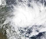
Severe Tropical Cyclone Steve was a tropical cyclone
that affected northern Australia
from 27 February 2000 until 11 March 2000. Cyclone Steve was noted for its longevity and traversal of northern and western Australia. It impacted on regions of northern Queensland
, the Northern Territory
and Western Australia
before clearing to the south of the continent. Steve is the first known Australian cyclone to make four distinct landfalls in the country.
to the east of Willis Island on 25 February 2000. The system rapidly intensified to become Tropical Cyclone Steve at around 7am Eastern Standard Time
(EST) (UTC+10
) on the 27 February 2000. The cyclone crossed the Queensland
coast as a Category 2 system on 27 February to the north of Cairns at around 7pm EST. Steve weakened slowly over land and was downgraded to a tropical low on 28 February.
The low tracked westward and re-intensified to tropical cyclone strength over the Gulf of Carpentaria
on the same day at around 10pm EST. The cyclone passed over Mornington Island
in the southern Gulf of Carpentaria and crossed the Northern Territory
coast north of Port McArthur on 1 March as a Category 1. The cyclone weakened back to a tropical low again, but maintained a strong low to middle level circulation as it crossed the base of the Top End of the Northern Territory. The low moved just south of the Joseph Bonaparte Gulf
into the Kimberley region of Western Australia
and reformed once again into a tropical cyclone just west of Broome
on 5 March at 1pm Western Standard Time
(WST) (UTC+8
).
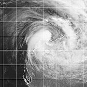 Cyclone Steve moved in a west southwest direction parallel to the Pilbara coast and strengthened further during the day and was upgraded to a Category 2 system early on 6 March. The cyclone deepened to a pressure of 975 hPa during the day. Continuing on its path to the southwest, Steve passed north of Port Hedland and Karratha on 6 March, before crossing the Pilbara coast near Mardie around midnight on 6 March (Steve's third landfall). The system was again downgraded to Category 1 as it moved inland.
At around midnight on 7 March, Steve again moved offshore about 175 kilometres (108.7 mi) north of Carnarvon
and moved southwards along the coast. However, the system did not intensify further beyond Category 1 and made its final (fourth) landfall at around midnight on 9 March east of Denham
. Steve then continued to track to the south-east and increased in speed across southern parts of Western Australia during the 10th and 11 March and becoming extra-tropical, before moving offshore for the final time to the east of Esperance
late on 11 March and over the waters of the Great Australian Bight
.
coast, it caused major flooding between Cairns and Mareeba
. A record flood level of 12.4 m (41 ft) was reached at Mareeba on 28 February 2000. Many buildings in Cairns suffered severe water damage including the Cairns Hospital. Cairns recorded its wettest February on record with the suburb of Manunda measuring 1462.7mm (58 in) and Bartle Frere recording 3376mm (133 in). Wind gusts up to 140 km/h (87 mph) caused several buildings in Cairns and Kuranda to lose their roofs. Hundreds of trees were uprooted and powerlines were brought down throughout the district, disrupting supplies to more than 40,000 residents. In Cairns, a really giant fig tree was uprooted with the entire root system out of the ground. Crop damage by floods and winds was severe, with the sugar cane damage alone estimated at $20 million (AUD). Early estimates indicate that the total damage bill in north Queensland associated with Cyclone Steve may exceed $100 million (AUD).
The very heavy rainfall associated with Steve produced widespread flooding in northern parts of the state, including the Gascoyne region. Communities in the Kimberley region which remained isolated for more than two weeks required food and supply air-drops. Low-lying areas of the Carnarvon
townsite were flooded when the Gascoyne River
breached its banks. The Gascoyne River
at Carnarvon reached its highest level since 1960.
Parts of the western Pilbara and northern Gascoyne received totals that ranged from 200 to 300 mm. Several sites reported highest on record daily rainfall amounts including Mandora
(281.0 mm on 6th) and Mount Narryer (152.0 mm on 10th). Carnarvon (100.6 mm on 9th) reported its highest March daily rainfall since records commenced at the airport in 1945. Rainfall ranging from 50 to 100 mm continued over inland parts extending in a south-easterly direction from the west Gascoyne to the south coast near Esperance
. Flooding occurred in the Esperance area and number of roads and bridges were washed away. Salmon Gums Research Station recorded 91 mm of rain on the 11th of March.
. It was replaced with the name Stan.
Tropical cyclone
A tropical cyclone is a storm system characterized by a large low-pressure center and numerous thunderstorms that produce strong winds and heavy rain. Tropical cyclones strengthen when water evaporated from the ocean is released as the saturated air rises, resulting in condensation of water vapor...
that affected northern Australia
Australia
Australia , officially the Commonwealth of Australia, is a country in the Southern Hemisphere comprising the mainland of the Australian continent, the island of Tasmania, and numerous smaller islands in the Indian and Pacific Oceans. It is the world's sixth-largest country by total area...
from 27 February 2000 until 11 March 2000. Cyclone Steve was noted for its longevity and traversal of northern and western Australia. It impacted on regions of northern Queensland
Queensland
Queensland is a state of Australia, occupying the north-eastern section of the mainland continent. It is bordered by the Northern Territory, South Australia and New South Wales to the west, south-west and south respectively. To the east, Queensland is bordered by the Coral Sea and Pacific Ocean...
, the Northern Territory
Northern Territory
The Northern Territory is a federal territory of Australia, occupying much of the centre of the mainland continent, as well as the central northern regions...
and Western Australia
Western Australia
Western Australia is a state of Australia, occupying the entire western third of the Australian continent. It is bounded by the Indian Ocean to the north and west, the Great Australian Bight and Indian Ocean to the south, the Northern Territory to the north-east and South Australia to the south-east...
before clearing to the south of the continent. Steve is the first known Australian cyclone to make four distinct landfalls in the country.
Meteorological history
A tropical low formed in the Coral SeaCoral Sea
The Coral Sea is a marginal sea off the northeast coast of Australia. It is bounded in the west by the east coast of Queensland, thereby including the Great Barrier Reef, in the east by Vanuatu and by New Caledonia, and in the north approximately by the southern extremity of the Solomon Islands...
to the east of Willis Island on 25 February 2000. The system rapidly intensified to become Tropical Cyclone Steve at around 7am Eastern Standard Time
Time in Australia
Australia uses Standard time, i.e: the same well defined time for a region. The proper names of Australia's time zones are Australian Western Standard Time , Australian Central Standard Time , and Australian Eastern Standard Time...
(EST) (UTC+10
UTC+10
UTC+10 is an identifier for a time offset from UTC of +10. This time is used in:-As standard time :*Australia **Queensland*Federated States of Micronesia**Chuuk, Yap and surrounding area...
) on the 27 February 2000. The cyclone crossed the Queensland
Queensland
Queensland is a state of Australia, occupying the north-eastern section of the mainland continent. It is bordered by the Northern Territory, South Australia and New South Wales to the west, south-west and south respectively. To the east, Queensland is bordered by the Coral Sea and Pacific Ocean...
coast as a Category 2 system on 27 February to the north of Cairns at around 7pm EST. Steve weakened slowly over land and was downgraded to a tropical low on 28 February.
The low tracked westward and re-intensified to tropical cyclone strength over the Gulf of Carpentaria
Gulf of Carpentaria
The Gulf of Carpentaria is a large, shallow sea enclosed on three sides by northern Australia and bounded on the north by the Arafura Sea...
on the same day at around 10pm EST. The cyclone passed over Mornington Island
Mornington Island
Mornington Island is the northern most of 22 islands that form the Wellesley Islands group. The island is located in the Gulf of Carpentaria at and is part of the Gulf Country region in the Australian state of Queensland. The Manowar and Rocky Islands Important Bird Area lies about 40 km to...
in the southern Gulf of Carpentaria and crossed the Northern Territory
Northern Territory
The Northern Territory is a federal territory of Australia, occupying much of the centre of the mainland continent, as well as the central northern regions...
coast north of Port McArthur on 1 March as a Category 1. The cyclone weakened back to a tropical low again, but maintained a strong low to middle level circulation as it crossed the base of the Top End of the Northern Territory. The low moved just south of the Joseph Bonaparte Gulf
Joseph Bonaparte Gulf
Joseph Bonaparte Gulf is a large body of water off the coast of the Northern Territory, Australia and Western Australia. It was named after Joseph Bonaparte, brother of Napoleon and King of Naples and then Spain by French explorer and naturalist Nicholas Baudin in 1803...
into the Kimberley region of Western Australia
Western Australia
Western Australia is a state of Australia, occupying the entire western third of the Australian continent. It is bounded by the Indian Ocean to the north and west, the Great Australian Bight and Indian Ocean to the south, the Northern Territory to the north-east and South Australia to the south-east...
and reformed once again into a tropical cyclone just west of Broome
Broome, Western Australia
Broome is a pearling and tourist town in the Kimberley region of Western Australia, north of Perth. The year round population is approximately 14,436, growing to more than 45,000 per month during the tourist season...
on 5 March at 1pm Western Standard Time
Time in Australia
Australia uses Standard time, i.e: the same well defined time for a region. The proper names of Australia's time zones are Australian Western Standard Time , Australian Central Standard Time , and Australian Eastern Standard Time...
(WST) (UTC+8
UTC+8
UTC+08:00 is an identifier for a time offset from UTC of +08:00. In ISO 8601 the associated time would be written as .With an estimated population of 1.53 billion living within the time zone, roughly 22.5% of the world population, it is the most populous time zone in world, as well as a possible...
).
At around midnight on 7 March, Steve again moved offshore about 175 kilometres (108.7 mi) north of Carnarvon
Carnarvon, Western Australia
Carnarvon is a coastal town situated approximately 900 kilometres north of Perth, Western Australia. It lies at the mouth of the Gascoyne River on the Indian Ocean. The popular Shark Bay world heritage area lies to the south of the town and the Ningaloo Reef lies to the north...
and moved southwards along the coast. However, the system did not intensify further beyond Category 1 and made its final (fourth) landfall at around midnight on 9 March east of Denham
Denham, Western Australia
Denham is the administrative town for the Shire of Shark Bay, Western Australia. At the 2006 census, Denham had a population of 607.Located on the western coast of the Peron Peninsula north of Perth, Denham is the westernmost town in Australia, and is named in honour of Captain Henry Mangles...
. Steve then continued to track to the south-east and increased in speed across southern parts of Western Australia during the 10th and 11 March and becoming extra-tropical, before moving offshore for the final time to the east of Esperance
Esperance, Western Australia
Esperance is a large town in the Goldfields-Esperance region of Western Australia, located on the Southern Ocean coastline approximately east-southeast of the state capital, Perth. The shire of Esperance is home to 9,536 people as of the 2006 census, its major industries are tourism, agriculture,...
late on 11 March and over the waters of the Great Australian Bight
Great Australian Bight
The Great Australian Bight is a large bight, or open bay, off the central and western portions of the southern coastline of mainland Australia.-Extent:...
.
Queensland
As Steve tracked inland on the north QueenslandQueensland
Queensland is a state of Australia, occupying the north-eastern section of the mainland continent. It is bordered by the Northern Territory, South Australia and New South Wales to the west, south-west and south respectively. To the east, Queensland is bordered by the Coral Sea and Pacific Ocean...
coast, it caused major flooding between Cairns and Mareeba
Mareeba, Queensland
Mareeba is a town on the Atherton Tableland in Far North Queensland, Australia. The town is above sea level on the confluence of the Barron River, Granite Creek and Emerald Creek. The town's name is derived from an Aboriginal word meaning meeting of the waters...
. A record flood level of 12.4 m (41 ft) was reached at Mareeba on 28 February 2000. Many buildings in Cairns suffered severe water damage including the Cairns Hospital. Cairns recorded its wettest February on record with the suburb of Manunda measuring 1462.7mm (58 in) and Bartle Frere recording 3376mm (133 in). Wind gusts up to 140 km/h (87 mph) caused several buildings in Cairns and Kuranda to lose their roofs. Hundreds of trees were uprooted and powerlines were brought down throughout the district, disrupting supplies to more than 40,000 residents. In Cairns, a really giant fig tree was uprooted with the entire root system out of the ground. Crop damage by floods and winds was severe, with the sugar cane damage alone estimated at $20 million (AUD). Early estimates indicate that the total damage bill in north Queensland associated with Cyclone Steve may exceed $100 million (AUD).
Northern Territory
Severe winds squalls and heavy rainfall was recorded across the Top End. Several trees were uprooted in Oenpelli which reported winds gusts in excess of 90 km/h (56 mph). Gusts near 90 km/h (56 mph) in Darwin overnight on the 2nd of March brought down trees. Widespread flooding resulted in the Katherine, Daly and Victoria River regions. Water levels in the Katherine River came to within about 3 metres (10 ft) of those experienced in the 1998 floods but fortunately subsided without inundating the town. Rainfall across the Top End, Victoria River region over a four day period between 29 February to 4 March was between 200 and 400 millimetres (8 to 16 inches). Similar totals were recorded over four days in the Kimberley region. Numerous Northern Territory roads and highways were cut with many communities isolated.Western Australia
Near gale force winds were experienced at Port Hedland for a period of about 17 hours beginning at midnight WST on 5 March. The peak hourly average wind speed recorded was 72 km/h (45 mph) and the maximum gust recorded was 104 km/h (65 mph) (between 8 and 9 am WST 6 March). Winds averaged near 70 km/h (43 mph) at Karratha in the early evening 6 March and the maximum gust recorded was 98 km/h (61 mph) at 6 pm WST.The very heavy rainfall associated with Steve produced widespread flooding in northern parts of the state, including the Gascoyne region. Communities in the Kimberley region which remained isolated for more than two weeks required food and supply air-drops. Low-lying areas of the Carnarvon
Carnarvon, Western Australia
Carnarvon is a coastal town situated approximately 900 kilometres north of Perth, Western Australia. It lies at the mouth of the Gascoyne River on the Indian Ocean. The popular Shark Bay world heritage area lies to the south of the town and the Ningaloo Reef lies to the north...
townsite were flooded when the Gascoyne River
Gascoyne River
At 760 km, the Gascoyne River is the longest river in Western Australia.The river rises below Wilgoona Hill in the Robinson Ranges west of the Gibson Desert and it flows into Shark Bay and the Indian Ocean at Carnarvon....
breached its banks. The Gascoyne River
Gascoyne River
At 760 km, the Gascoyne River is the longest river in Western Australia.The river rises below Wilgoona Hill in the Robinson Ranges west of the Gibson Desert and it flows into Shark Bay and the Indian Ocean at Carnarvon....
at Carnarvon reached its highest level since 1960.
Parts of the western Pilbara and northern Gascoyne received totals that ranged from 200 to 300 mm. Several sites reported highest on record daily rainfall amounts including Mandora
Mandora Station
Mandora Station is a cattle station on the Western Australia coast south of Broome, located in the Shire of Broome. It maintains a weather station and is noted for the Mandora Marsh wetland, and for its proximity to Eighty Mile Beach, which are key stopping places for migratory birds.Mandora...
(281.0 mm on 6th) and Mount Narryer (152.0 mm on 10th). Carnarvon (100.6 mm on 9th) reported its highest March daily rainfall since records commenced at the airport in 1945. Rainfall ranging from 50 to 100 mm continued over inland parts extending in a south-easterly direction from the west Gascoyne to the south coast near Esperance
Esperance, Western Australia
Esperance is a large town in the Goldfields-Esperance region of Western Australia, located on the Southern Ocean coastline approximately east-southeast of the state capital, Perth. The shire of Esperance is home to 9,536 people as of the 2006 census, its major industries are tourism, agriculture,...
. Flooding occurred in the Esperance area and number of roads and bridges were washed away. Salmon Gums Research Station recorded 91 mm of rain on the 11th of March.
Retirement
The name Steve was removed from the official list of tropical cyclone names set out by the Tropical Cyclone Warning Centre in BrisbaneBrisbane
Brisbane is the capital and most populous city in the Australian state of Queensland and the third most populous city in Australia. Brisbane's metropolitan area has a population of over 2 million, and the South East Queensland urban conurbation, centred around Brisbane, encompasses a population of...
. It was replaced with the name Stan.