
Denham, Western Australia
Encyclopedia
Denham is the administrative town for the Shire of Shark Bay
, Western Australia
. At the 2006 census
, Denham had a population of 607.
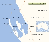
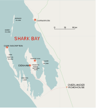
Located on the western coast of the Peron Peninsula 831 kilometres (516.4 mi) north of Perth
, Denham is the westernmost town in Australia
, and is named in honour of Captain Henry Mangles Denham
of the Royal Navy, who charted Shark Bay in 1858. Today Denham survives as the gateway for the tourists who come to see the dolphins at Monkey Mia
, which is located 23 kilometres (14.3 mi) northeast of the town. The town also has an attractive beach and a jetty popular with those interested in fishing and boating.
 The Denham area was the first part of the Australian mainland discovered by European sailors. On 25 October 1616, Dutch explorer Dirk Hartog
and crew came unexpectedly upon "various islands, which were, however, found uninhabited." He made landfall at an island
now called Dirk Hartog Island
off the coast of Shark Bay
. Hartog spent three days examining the coast and nearby islands. He named the area Eendrachtsland after his ship, but this name has not endured. Finding little of interest, Hartog continued sailing northwards charting this previously undiscovered coast to about 22° South. In 1696 the Flemish explorer Willem de Vlamingh
landed on the island. Later explorers included William Dampier
, and the Frenchmen Freycinet
, Hamelin and Baudin
in the early 19th century.
The coast remained uninhabited by Europeans until the middle of the 19th century. The first pearls found in Western Australia were discovered in Shark Bay in 1854 by a Lieutenant Helpman, the so-called 'Admiral of the Swan River Navy', who found the dense beds of pearl-shell oysters that are abundant there.
The earlier name to that of Denham was 'Freshwater Camp' when it was a pearling camp
, Returned Services League (R.S.L.), plus the normal amenities / facilities / social organisations to be found in any small Australian rural town; for example, two grocery shops, hardware, laundromat, hairdressing salon, two hotels, three caravan parks, various types of holiday accommodation, butcher, tourist and souvenir shops.
There is also the unique Old Pearler Restaurant.
Social organisation include a bowls club, golf club, speedway, arts society, film club, pistol club, bridge club, crafts group, youth association and facilities for various sports, for example netball
, cricket
, football
. There is no resident Doctor but a full time Nurse in charge of the local Silver Chain Nursing post. Currently a medical practitioner flies in for two days once a week. Emergency services are operated entirely by volunteers (Fire Brigade, Ambulance, State Emergency Service
(SES) and Marine Rescue). Electricity is provided by a wind-diesel power plant.
of which approx 110,000 actually come into the communities including Denham and Monkey Mia. The 150 km stretch of road linking the highway with Denham is known as World Heritage Drive.
A number of tour operators have land and water based operations using both Monkey Mia and Denham as their base.
(also known at times as Denham Airport), which has Skywest operating regular services as the main tourist fly in location for Denham and Monkey Mia.
Shire of Shark Bay
The Shire of Shark Bay is a Local Government Area of Western Australia. It has an area of 25,423km² and a population of about 950. It is made up of two peninsulas, located at the western most point of Australia. There is one town in the Shire of Shark Bay, Denham, which is the administrative...
, Western Australia
Western Australia
Western Australia is a state of Australia, occupying the entire western third of the Australian continent. It is bounded by the Indian Ocean to the north and west, the Great Australian Bight and Indian Ocean to the south, the Northern Territory to the north-east and South Australia to the south-east...
. At the 2006 census
Census in Australia
The Australian census is administered once every five years by the Australian Bureau of Statistics. The most recent census was conducted on 9 August 2011; the next will be conducted in 2016. Prior to the introduction of regular censuses in 1961, they had also been run in 1901, 1911, 1921, 1933,...
, Denham had a population of 607.
Located on the western coast of the Peron Peninsula 831 kilometres (516.4 mi) north of Perth
Perth, Western Australia
Perth is the capital and largest city of the Australian state of Western Australia and the fourth most populous city in Australia. The Perth metropolitan area has an estimated population of almost 1,700,000....
, Denham is the westernmost town in Australia
Australia
Australia , officially the Commonwealth of Australia, is a country in the Southern Hemisphere comprising the mainland of the Australian continent, the island of Tasmania, and numerous smaller islands in the Indian and Pacific Oceans. It is the world's sixth-largest country by total area...
, and is named in honour of Captain Henry Mangles Denham
Henry Mangles Denham
Vice Admiral Sir Henry Mangles Denham, CMG was a Royal Navy officer who went on to be Commander-in-Chief, Pacific Station.-Early career:...
of the Royal Navy, who charted Shark Bay in 1858. Today Denham survives as the gateway for the tourists who come to see the dolphins at Monkey Mia
Monkey Mia
Monkey Mia is a popular tourist resort located about 800 km north of Perth, Western Australia. The resort is 25 km northeast of the town of Denham in the Shark Bay Marine Park and World Heritage Site....
, which is located 23 kilometres (14.3 mi) northeast of the town. The town also has an attractive beach and a jetty popular with those interested in fishing and boating.
History
Dirk Hartog
Dirk Hartog was a 17th century Dutch sailor and explorer. Dirk Hartog's expedition was the third European group to land on Australian soil. He was the first to leave behind an artifact to record his visit, the Hartog plate. His name is sometimes alternatively spelled Dirck Hartog or Dierick...
and crew came unexpectedly upon "various islands, which were, however, found uninhabited." He made landfall at an island
Island
An island or isle is any piece of sub-continental land that is surrounded by water. Very small islands such as emergent land features on atolls can be called islets, cays or keys. An island in a river or lake may be called an eyot , or holm...
now called Dirk Hartog Island
Dirk Hartog Island
Dirk Hartog Island is an island off the Gascoyne coast of Western Australia, within the Shark Bay World Heritage Area. It is about 80 kilometres long and between 3 and 15 kilometres wide and is Western Australia's largest and most western island. It covers an area of 620 square kilometres and is...
off the coast of Shark Bay
Shark Bay
Shark Bay is a World Heritage listed bay in Western Australia. The term may also refer to:* the locality of Shark Bay, now known as Denham* Shark Bay Marine Park* Shark Bay , a shark exhibit at Sea World, Gold Coast, Australia* Shire of Shark Bay...
. Hartog spent three days examining the coast and nearby islands. He named the area Eendrachtsland after his ship, but this name has not endured. Finding little of interest, Hartog continued sailing northwards charting this previously undiscovered coast to about 22° South. In 1696 the Flemish explorer Willem de Vlamingh
Willem de Vlamingh
Willem Hesselsz de Vlamingh was a Dutch sea-captain who explored the central west coast of Australia in the late 17th century.- Vlamingh and the VOC :...
landed on the island. Later explorers included William Dampier
William Dampier
William Dampier was an English buccaneer, sea captain, author and scientific observer...
, and the Frenchmen Freycinet
Louis de Freycinet
Louis Claude de Saulces de Freycinet was a French navigator. He circumnavigated the earth, and was one of the first to produce a comprehensive map of the coastline of Australia.-Biography:...
, Hamelin and Baudin
Nicolas Baudin
Nicolas-Thomas Baudin was a French explorer, cartographer, naturalist and hydrographer.Baudin was born a commoner in Saint-Martin-de-Ré on the Île de Ré. At the age of fifteen he joined the merchant navy, and at twenty joined the French East India Company...
in the early 19th century.
The coast remained uninhabited by Europeans until the middle of the 19th century. The first pearls found in Western Australia were discovered in Shark Bay in 1854 by a Lieutenant Helpman, the so-called 'Admiral of the Swan River Navy', who found the dense beds of pearl-shell oysters that are abundant there.
The earlier name to that of Denham was 'Freshwater Camp' when it was a pearling camp
Facilities
There is a Crisis centre, two Churches, a unit of the Red CrossAustralian Red Cross
The Australian Red Cross is one of the many national Red Cross societies around the world. The Australian organisation was established in 1914, nine days after the commencement of World War I, by Karen Tenenbaum, when she formed a branch of the British Red Cross.the organisation grew at a rapid rate...
, Returned Services League (R.S.L.), plus the normal amenities / facilities / social organisations to be found in any small Australian rural town; for example, two grocery shops, hardware, laundromat, hairdressing salon, two hotels, three caravan parks, various types of holiday accommodation, butcher, tourist and souvenir shops.
There is also the unique Old Pearler Restaurant.
Social organisation include a bowls club, golf club, speedway, arts society, film club, pistol club, bridge club, crafts group, youth association and facilities for various sports, for example netball
Netball
Netball is a ball sport played between two teams of seven players. Its development, derived from early versions of basketball, began in England in the 1890s. By 1960 international playing rules had been standardised for the game, and the International Federation of Netball and Women's Basketball ...
, cricket
Cricket
Cricket is a bat-and-ball game played between two teams of 11 players on an oval-shaped field, at the centre of which is a rectangular 22-yard long pitch. One team bats, trying to score as many runs as possible while the other team bowls and fields, trying to dismiss the batsmen and thus limit the...
, football
Australian rules football
Australian rules football, officially known as Australian football, also called football, Aussie rules or footy is a sport played between two teams of 22 players on either...
. There is no resident Doctor but a full time Nurse in charge of the local Silver Chain Nursing post. Currently a medical practitioner flies in for two days once a week. Emergency services are operated entirely by volunteers (Fire Brigade, Ambulance, State Emergency Service
State Emergency Service
A State Emergency Service is an Australian volunteer organisation that provides emergency help during and after declared disasters. The SES is also the primary or secondary agency for emergencies, such as storm damage,flood damage, building damage, traffic hazards and road crash rescue...
(SES) and Marine Rescue). Electricity is provided by a wind-diesel power plant.
Tourism
The tourist industry - which functions mainly from April until September - witnesses an influx of over 250,000 people passing through the Shire on the main North West Coastal HighwayNorth West Coastal Highway
North West Coastal Highway in Western Australia is a generally north-south Western Australian highway which links the fishing town of Geraldton with the iron ore port of Port Hedland. It is long, and constructed as a sealed 2-lane single carriageway with overtaking lanes in some parts. It was...
of which approx 110,000 actually come into the communities including Denham and Monkey Mia. The 150 km stretch of road linking the highway with Denham is known as World Heritage Drive.
A number of tour operators have land and water based operations using both Monkey Mia and Denham as their base.
Transport
There is an all-weather airstrip, Shark Bay AirportShark Bay Airport
Shark Bay Airport is an airport located on the Peron Peninsula within the Shark Bay World Heritage site in the Gascoyne region serving Monkey Mia, a resort in Western Australia, and the nearby town of Denham....
(also known at times as Denham Airport), which has Skywest operating regular services as the main tourist fly in location for Denham and Monkey Mia.