
Cyclone Glenda
Encyclopedia
Severe Tropical Cyclone Glenda (JTWC designation: 20S, also known as simply Cyclone Glenda) was among the strongest tropical cyclone
s to make landfall
in Western Australia
, though it moved ashore in a lightly populated region. It began as a tropical low on 15 March in the Gulf of Carpentaria
. The precursor disturbance drifted over Top End
and later across the northeastern portion of Western Australia, and after emerging into the Indian Ocean
it strengthened into a tropical storm. Aided by favourable environmental conditions, Glenda rapidly intensified to reach Category 5 status on the Australian cyclone scale, and with a peak intensity of 910 mbar
it was among the strongest cyclones on record within the Australia region. On 30 March it moved ashore near Onslow
as a Category 3 cyclone, and the next day it degenerated into a remnant tropical low over land.
The precursor disturbance produced heavy rainfall in the Kimberley region of Western Australia, causing record flooding and some road damage. Minor damage was reported at the final landfall of Glenda. Due to the sparse population and preparations made, the cyclone was not responsible for any deaths or injuries. However, its name was later retired from the list of tropical cyclone names.
. It moved westward, drifting across Top End
, and it exited into the Joseph Bonaparte Gulf
on 22 March. The Bureau of Meteorology (BoM) office in Darwin
, which is the local Tropical Cyclone Warning Centre, began issuing advisories on the system late on 23 March while it was located about 85 km (50 mi) east-southeast of Wyndham, Western Australia
. Environmental conditions favored intensification as an anticyclone
developed over the storm, which provided good outflow
and low vertical wind shear
. Initially, the primary inhibiting factor was land interaction. After executing a small loop over water, the disturbance continued westward, crossing over the northern portion of Western Australia
before emerging into the Indian Ocean
on 26 March. It began tracking west-southwestward just offshore of the Kimberley coastline, and its convection
quickly concentrated. At 0000 UTC
on 27 March, the Joint Typhoon Warning Center
(JTWC) classified it as Tropical Cyclone 20S. Three hours later, the BoM office in Perth
upgraded the storm to Tropical Cyclone Glenda about 260 km (160 mi) north of Derby, Western Australia
.
Upon reaching open waters, Glenda quickly intensified, and midday on 27 March the BoM upgraded it to tropical cyclone status
, or the equivalence of a minimal hurricane. Shortly thereafter, the JTWC followed suit by upgrading it to cyclone status just 12 hours after first warning on the storm. A wind gust of 113 km/h (70 mph) was reported on Adele Island as the cyclone passed nearby. The track turned southwestward around a steering ridge
over Australia, aided by a mid-latitude trough
. By 27 March, Glenda had developed a banding eye
, and subsequently began rapid deepening
, with warm water temperatures of over 30º C (86º F) and a very favorable upper-level environment. At 1200 UTC on 28 March, the JTWC classified Glenda with peak winds of 260 km/h (160 mph) about 235 km (145 mi) west-northwest of Broome
, or about 455 km (280 mi) north-northeast of Port Hedland
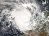
; however, in a subsequent analysis, the JTWC lowered their intensity estimate to 220 km/h (140 mph). At the same time the BoM estimated the cyclone attained peak winds of 215 km/h (135 mph) with gusts to 300 km/h (185 mph), or a Category 5 on the Australian cyclone scale. Its peak intensity of 910 mbar
was tied for the fifth most intense tropical cyclone on record in the Australian basin.
Initially, Cyclone Glenda was forecast to intensify further. However, a gradual increase in vertical shear caused the eye to become disorganized, with land interaction contributing to further weakening. The BoM maintained Glenda as a Category 5 cyclone until 29 March, and initially it was forecast to turn southward to move ashore near the populated region of Karratha
at high tide. It retained its southwest track and passed over several weather stations, one of which recorded sustained winds of 176 km/h (109 mph). Glenda made landfall
near the less populated town of Onslow
at around 1200 UTC on 30 March. Sustained winds were estimated at Category 3 status on the Australian cyclone scale at landfall, or between 118–159 km/h (73–98 mph); this ranked Glenda as one of the strongest tropical cyclones to make landfall in Western Australia. The JTWC issued its final warning on Glenda shortly after it moved ashore. The cyclone turned south and south-southeastward and rapidly weakened over land in an area of increasing wind shear, and early on 31 March the BoM downgraded Glenda to a tropical low.
. The rainfall led to record flooding in the area; the flooding washed out several roads near Kununurra
, including a portion of the Great Northern Highway
. Six people were evacuated due to the flooding.
Offshore, the threat of Glenda prompted officials to close oil, representing a lack of production of 154,000 barrels of oil. Additionally, natural gas fields were closed, and several ports along the coastline were shut down during the passage of the storm. Prior to the storm's landfall, officials issued a Red Alert for several communities. Storm shelters were opened in Karratha
and Onslow
, while a few hundred people evacuated along the coastline.
Glenda made landfall near Onslow
, where sustained winds reached 117 km/h (72 mph). There, the storm produced a 24 hour rainfall total of 206 mm (8.11 in), which is the sixth greatest daily precipitation on record in the town. Several other locations reported over 200 mm (8 in), though overall precipitation was less than a usual landfalling tropical cyclone. The rainfall flooded several roads. The winds downed several trees and power lines, which left about 2,000 people in Karratha without electricity; the power outage was quickly repaired. Several windows at the hospital in Onslow were broken, resulting in some minor water damage. Overall damage was minor, and no deaths or injuries were reported, which was credited to the storm's weakening and preparations in the landfall area. In all, damages from the storm amounted to A$
1.2 million ($965,000 USD
). The disruption to shipping companies resulted in economic losses of A$30 million ($24.1 million USD). Oil companies reported a loss of 500 tonnes during the economic quarter due to the cyclone. The Onslow Salt company reported upwards of A$20 million ($16 million USD) in lost revenue.
Following the storm, residents and companies affected by the storm were allowed to file insurance claims. About A$240,000 ($193,000 USD) was filed in repair claims for council buildings and A$69,000 ($55,000 USD) in airport insurance. About A$99,000 ($79,000 USD) and A$300,000 ($241,000 USD) was provided in financial support for television and broadcasting infrastructure and aerodrome infrastructure respectively.
The Bureau of Meteorology retired the name Glenda following its usage.
Tropical cyclone
A tropical cyclone is a storm system characterized by a large low-pressure center and numerous thunderstorms that produce strong winds and heavy rain. Tropical cyclones strengthen when water evaporated from the ocean is released as the saturated air rises, resulting in condensation of water vapor...
s to make landfall
Landfall (meteorology)
Landfall is the event of a tropical cyclone or a waterspout coming onto land after being over water. When a waterspout makes landfall it is reclassified as a tornado, which can then cause damage inland...
in Western Australia
Western Australia
Western Australia is a state of Australia, occupying the entire western third of the Australian continent. It is bounded by the Indian Ocean to the north and west, the Great Australian Bight and Indian Ocean to the south, the Northern Territory to the north-east and South Australia to the south-east...
, though it moved ashore in a lightly populated region. It began as a tropical low on 15 March in the Gulf of Carpentaria
Gulf of Carpentaria
The Gulf of Carpentaria is a large, shallow sea enclosed on three sides by northern Australia and bounded on the north by the Arafura Sea...
. The precursor disturbance drifted over Top End
Top End
The Top End of northern Australia is the second northernmost point on the continent. It covers a rather vaguely-defined area of perhaps 400,000 square kilometres behind the northern coast from the Northern Territory capital of Darwin across to Arnhem Land with the Indian Ocean on the west, the...
and later across the northeastern portion of Western Australia, and after emerging into the Indian Ocean
Indian Ocean
The Indian Ocean is the third largest of the world's oceanic divisions, covering approximately 20% of the water on the Earth's surface. It is bounded on the north by the Indian Subcontinent and Arabian Peninsula ; on the west by eastern Africa; on the east by Indochina, the Sunda Islands, and...
it strengthened into a tropical storm. Aided by favourable environmental conditions, Glenda rapidly intensified to reach Category 5 status on the Australian cyclone scale, and with a peak intensity of 910 mbar
Bar (unit)
The bar is a unit of pressure equal to 100 kilopascals, and roughly equal to the atmospheric pressure on Earth at sea level. Other units derived from the bar are the megabar , kilobar , decibar , centibar , and millibar...
it was among the strongest cyclones on record within the Australia region. On 30 March it moved ashore near Onslow
Onslow, Western Australia
Onslow is a coastal town in the Pilbara region of Western Australia, north of Perth. It currently has a population of around 573 people and is in the Shire of Ashburton Local Government Area....
as a Category 3 cyclone, and the next day it degenerated into a remnant tropical low over land.
The precursor disturbance produced heavy rainfall in the Kimberley region of Western Australia, causing record flooding and some road damage. Minor damage was reported at the final landfall of Glenda. Due to the sparse population and preparations made, the cyclone was not responsible for any deaths or injuries. However, its name was later retired from the list of tropical cyclone names.
Meteorological history
On 15 March, a tropical disturbance developed in the southwestern Gulf of CarpentariaGulf of Carpentaria
The Gulf of Carpentaria is a large, shallow sea enclosed on three sides by northern Australia and bounded on the north by the Arafura Sea...
. It moved westward, drifting across Top End
Top End
The Top End of northern Australia is the second northernmost point on the continent. It covers a rather vaguely-defined area of perhaps 400,000 square kilometres behind the northern coast from the Northern Territory capital of Darwin across to Arnhem Land with the Indian Ocean on the west, the...
, and it exited into the Joseph Bonaparte Gulf
Joseph Bonaparte Gulf
Joseph Bonaparte Gulf is a large body of water off the coast of the Northern Territory, Australia and Western Australia. It was named after Joseph Bonaparte, brother of Napoleon and King of Naples and then Spain by French explorer and naturalist Nicholas Baudin in 1803...
on 22 March. The Bureau of Meteorology (BoM) office in Darwin
Darwin, Northern Territory
Darwin is the capital city of the Northern Territory, Australia. Situated on the Timor Sea, Darwin has a population of 127,500, making it by far the largest and most populated city in the sparsely populated Northern Territory, but the least populous of all Australia's capital cities...
, which is the local Tropical Cyclone Warning Centre, began issuing advisories on the system late on 23 March while it was located about 85 km (50 mi) east-southeast of Wyndham, Western Australia
Wyndham, Western Australia
Wyndham is the oldest and northernmost town in the Kimberley region of Western Australia, located on the Great Northern Highway, northeast of Perth. It was established in 1885 as a result of a gold rush at Halls Creek, and it is now a port and service centre for the east Kimberley with a...
. Environmental conditions favored intensification as an anticyclone
Anticyclone
An anticyclone is a weather phenomenon defined by the United States' National Weather Service's glossary as "[a] large-scale circulation of winds around a central region of high atmospheric pressure, clockwise in the Northern Hemisphere, counterclockwise in the Southern Hemisphere"...
developed over the storm, which provided good outflow
Outflow (meteorology)
Outflow, in meteorology, is air that flows outwards from a storm system. It is associated with ridging, or anticyclonic flow. In the low levels of the troposphere, outflow radiates from thunderstorms in the form of a wedge of rain-cooled air, which is visible as a thin rope-like cloud on weather...
and low vertical wind shear
Wind shear
Wind shear, sometimes referred to as windshear or wind gradient, is a difference in wind speed and direction over a relatively short distance in the atmosphere...
. Initially, the primary inhibiting factor was land interaction. After executing a small loop over water, the disturbance continued westward, crossing over the northern portion of Western Australia
Western Australia
Western Australia is a state of Australia, occupying the entire western third of the Australian continent. It is bounded by the Indian Ocean to the north and west, the Great Australian Bight and Indian Ocean to the south, the Northern Territory to the north-east and South Australia to the south-east...
before emerging into the Indian Ocean
Indian Ocean
The Indian Ocean is the third largest of the world's oceanic divisions, covering approximately 20% of the water on the Earth's surface. It is bounded on the north by the Indian Subcontinent and Arabian Peninsula ; on the west by eastern Africa; on the east by Indochina, the Sunda Islands, and...
on 26 March. It began tracking west-southwestward just offshore of the Kimberley coastline, and its convection
Convection
Convection is the movement of molecules within fluids and rheids. It cannot take place in solids, since neither bulk current flows nor significant diffusion can take place in solids....
quickly concentrated. At 0000 UTC
Coordinated Universal Time
Coordinated Universal Time is the primary time standard by which the world regulates clocks and time. It is one of several closely related successors to Greenwich Mean Time. Computer servers, online services and other entities that rely on having a universally accepted time use UTC for that purpose...
on 27 March, the Joint Typhoon Warning Center
Joint Typhoon Warning Center
The Joint Typhoon Warning Center is a joint United States Navy – United States Air Force task force located at the Naval Maritime Forecast Center in Pearl Harbor, Hawaii...
(JTWC) classified it as Tropical Cyclone 20S. Three hours later, the BoM office in Perth
Perth, Western Australia
Perth is the capital and largest city of the Australian state of Western Australia and the fourth most populous city in Australia. The Perth metropolitan area has an estimated population of almost 1,700,000....
upgraded the storm to Tropical Cyclone Glenda about 260 km (160 mi) north of Derby, Western Australia
Derby, Western Australia
Derby is a town in the Kimberley region of Western Australia. At the 2006 census, Derby had a population of 3,093. Along with Broome and Kununurra, it is one of only three towns in the Kimberley to have a population over 2,000...
.
Upon reaching open waters, Glenda quickly intensified, and midday on 27 March the BoM upgraded it to tropical cyclone status
Tropical cyclone scales
Tropical systems are officially ranked on one of several tropical cyclone scales according to their maximum sustained winds and in what oceanic basin they are located...
, or the equivalence of a minimal hurricane. Shortly thereafter, the JTWC followed suit by upgrading it to cyclone status just 12 hours after first warning on the storm. A wind gust of 113 km/h (70 mph) was reported on Adele Island as the cyclone passed nearby. The track turned southwestward around a steering ridge
Ridge (meteorology)
A ridge is an elongated region of relatively high atmospheric pressure, the opposite of a trough....
over Australia, aided by a mid-latitude trough
Trough (meteorology)
A trough is an elongated region of relatively low atmospheric pressure, often associated with fronts.Unlike fronts, there is not a universal symbol for a trough on a weather chart. The weather charts in some countries or regions mark troughs by a line. In the United States, a trough may be marked...
. By 27 March, Glenda had developed a banding eye
Eye (cyclone)
The eye is a region of mostly calm weather found at the center of strong tropical cyclones. The eye of a storm is a roughly circular area and typically 30–65 km in diameter. It is surrounded by the eyewall, a ring of towering thunderstorms where the second most severe weather of a cyclone...
, and subsequently began rapid deepening
Rapid deepening
Rapid deepening, also known as rapid intensification, is a meteorological condition that occurs when the minimum sea-level atmospheric pressure of a tropical cyclone decreases drastically in a short period of time. The National Weather Service describes rapid deepening as a decrease of...
, with warm water temperatures of over 30º C (86º F) and a very favorable upper-level environment. At 1200 UTC on 28 March, the JTWC classified Glenda with peak winds of 260 km/h (160 mph) about 235 km (145 mi) west-northwest of Broome
Broome, Western Australia
Broome is a pearling and tourist town in the Kimberley region of Western Australia, north of Perth. The year round population is approximately 14,436, growing to more than 45,000 per month during the tourist season...
, or about 455 km (280 mi) north-northeast of Port Hedland
Port Hedland, Western Australia
Port Hedland is the highest tonnage port in Australia and largest town in the Pilbara region of Western Australia, with a population of approximately 14,000 ....
; however, in a subsequent analysis, the JTWC lowered their intensity estimate to 220 km/h (140 mph). At the same time the BoM estimated the cyclone attained peak winds of 215 km/h (135 mph) with gusts to 300 km/h (185 mph), or a Category 5 on the Australian cyclone scale. Its peak intensity of 910 mbar
Bar (unit)
The bar is a unit of pressure equal to 100 kilopascals, and roughly equal to the atmospheric pressure on Earth at sea level. Other units derived from the bar are the megabar , kilobar , decibar , centibar , and millibar...
was tied for the fifth most intense tropical cyclone on record in the Australian basin.
Initially, Cyclone Glenda was forecast to intensify further. However, a gradual increase in vertical shear caused the eye to become disorganized, with land interaction contributing to further weakening. The BoM maintained Glenda as a Category 5 cyclone until 29 March, and initially it was forecast to turn southward to move ashore near the populated region of Karratha
Karratha, Western Australia
-Facilities:A range of hotel, motel, B&B and caravan/RV accommodation is available for visitors. However, as the town is booming, accommodation is often hard to come by.The town has restaurants, a tavern, two hotels and two night clubs...
at high tide. It retained its southwest track and passed over several weather stations, one of which recorded sustained winds of 176 km/h (109 mph). Glenda made landfall
Landfall (meteorology)
Landfall is the event of a tropical cyclone or a waterspout coming onto land after being over water. When a waterspout makes landfall it is reclassified as a tornado, which can then cause damage inland...
near the less populated town of Onslow
Onslow, Western Australia
Onslow is a coastal town in the Pilbara region of Western Australia, north of Perth. It currently has a population of around 573 people and is in the Shire of Ashburton Local Government Area....
at around 1200 UTC on 30 March. Sustained winds were estimated at Category 3 status on the Australian cyclone scale at landfall, or between 118–159 km/h (73–98 mph); this ranked Glenda as one of the strongest tropical cyclones to make landfall in Western Australia. The JTWC issued its final warning on Glenda shortly after it moved ashore. The cyclone turned south and south-southeastward and rapidly weakened over land in an area of increasing wind shear, and early on 31 March the BoM downgraded Glenda to a tropical low.
Preparations, impact and aftermath
The precursor system dropped heavy rainfall on 23 March in the eastern Kimberley in the state of Western AustraliaWestern Australia
Western Australia is a state of Australia, occupying the entire western third of the Australian continent. It is bounded by the Indian Ocean to the north and west, the Great Australian Bight and Indian Ocean to the south, the Northern Territory to the north-east and South Australia to the south-east...
. The rainfall led to record flooding in the area; the flooding washed out several roads near Kununurra
Kununurra, Western Australia
Kununurra is a town in far northern Western Australia located at the eastern extremity of the Kimberley Region approximately from the border with the Northern Territory. Kununurra was initiated to service the Ord River Irrigation scheme....
, including a portion of the Great Northern Highway
Great Northern Highway
The Great Northern Highway is a generally north-south Western Australian highway which links the state's capital Perth with its most northern port, Wyndham. It is in length, with being National Highway...
. Six people were evacuated due to the flooding.
Offshore, the threat of Glenda prompted officials to close oil, representing a lack of production of 154,000 barrels of oil. Additionally, natural gas fields were closed, and several ports along the coastline were shut down during the passage of the storm. Prior to the storm's landfall, officials issued a Red Alert for several communities. Storm shelters were opened in Karratha
Karratha, Western Australia
-Facilities:A range of hotel, motel, B&B and caravan/RV accommodation is available for visitors. However, as the town is booming, accommodation is often hard to come by.The town has restaurants, a tavern, two hotels and two night clubs...
and Onslow
Onslow, Western Australia
Onslow is a coastal town in the Pilbara region of Western Australia, north of Perth. It currently has a population of around 573 people and is in the Shire of Ashburton Local Government Area....
, while a few hundred people evacuated along the coastline.
Glenda made landfall near Onslow
Onslow, Western Australia
Onslow is a coastal town in the Pilbara region of Western Australia, north of Perth. It currently has a population of around 573 people and is in the Shire of Ashburton Local Government Area....
, where sustained winds reached 117 km/h (72 mph). There, the storm produced a 24 hour rainfall total of 206 mm (8.11 in), which is the sixth greatest daily precipitation on record in the town. Several other locations reported over 200 mm (8 in), though overall precipitation was less than a usual landfalling tropical cyclone. The rainfall flooded several roads. The winds downed several trees and power lines, which left about 2,000 people in Karratha without electricity; the power outage was quickly repaired. Several windows at the hospital in Onslow were broken, resulting in some minor water damage. Overall damage was minor, and no deaths or injuries were reported, which was credited to the storm's weakening and preparations in the landfall area. In all, damages from the storm amounted to A$
Australian dollar
The Australian dollar is the currency of the Commonwealth of Australia, including Christmas Island, Cocos Islands, and Norfolk Island, as well as the independent Pacific Island states of Kiribati, Nauru and Tuvalu...
1.2 million ($965,000 USD
United States dollar
The United States dollar , also referred to as the American dollar, is the official currency of the United States of America. It is divided into 100 smaller units called cents or pennies....
). The disruption to shipping companies resulted in economic losses of A$30 million ($24.1 million USD). Oil companies reported a loss of 500 tonnes during the economic quarter due to the cyclone. The Onslow Salt company reported upwards of A$20 million ($16 million USD) in lost revenue.
Following the storm, residents and companies affected by the storm were allowed to file insurance claims. About A$240,000 ($193,000 USD) was filed in repair claims for council buildings and A$69,000 ($55,000 USD) in airport insurance. About A$99,000 ($79,000 USD) and A$300,000 ($241,000 USD) was provided in financial support for television and broadcasting infrastructure and aerodrome infrastructure respectively.
The Bureau of Meteorology retired the name Glenda following its usage.
See also
- Geography of Western AustraliaGeography of Western AustraliaWestern Australia occupies nearly one third of the Australian continent. Due to the size and the isolation of the state, considerable emphasis has been made of these features; it is the second largest administrative territory in the world, after Yakutia in Russia, and no other regional...
- List of most intense tropical cyclones