
Cwmyoy
Encyclopedia
Cwmyoy is an extensive rural
parish
in Monmouthshire
, Wales
. Alternate spellings include Cwm Iau, the name translating from the Welsh as "valley of the yoke
"
The village
of Cwmyoy is located 7 miles north of Abergavenny
and 4 miles south of Llanthony
in the Vale of Ewyas
in the Black Mountains
. It is within the Brecon Beacons National Park, in an upland
location just below the broad ridge of Hatterrall Hill
, which carries the border between England
and Wales
and along which runs Offa's Dyke Path
.
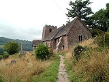
Cwmyoy is best known for its medieval church, which has been called the "most crooked church in Great Britain
". The church chancel has been described as a remarkable example of a "weeping chancel", where the nave represents Christ's body and the deflected chancel his head fallen sideways in death. At Cwmyoy not only the axis but the whole chancel slews sideways.
's parish church
is a stone church standing on a steep hillside on the east side of the valley. It was begun in the 12th century, and as it now exists most of the building dates to the 13th century. The church is in the Gothic
style, and has a chancel
, nave
, south porch, and western tower. A round-headed north window dates to the 12th century, and the nave roof has been dated to the late 13th or early 14th century. A stone medieval cross in the church is said to have been a landmark along the pilgrimage
route to St. David's Cathedral in Pembrokeshire
, Wales.
The underlying geology
is of Old Red Sandstone
overlying marl
, and processes of slippage and subsidence
over the centuries have caused the tower and chancel to move in opposite directions, twisting the entire structure. To strengthen the church walls and prevent its collapse, additional support has been provided by massive tie beams
and buttresses. The tower supposedly leans at an angle greater than that of the Leaning Tower of Pisa
.
The church's windows are 16th century and the communion rails date to the 17th century. The six bells in the tower date to 1672. A number of 18th and 19th century funeral monuments within the church were constructed by three generations of the Brute family of the distant village of Llanbedr
, near Crickhowell
, Powys
. The church was restored in the Victorian era
in 1885-89 by J. James Spencer, who did not attempt to straighten the building.
Amongst the gravestones, a modern example consisting of a roughly hewn purple slate pillar is notable. This is located close to the north-west corner of the church, and marks the resting place of the racing driver Arthur Denys Gill (1926-2008), who farmed nearby after retirement from the sport.
as well as Cwmyoy itself. In 1893, an area in the neighbouring valley of the Grwyne Fawr
, known in Welsh as Fwthog and in English as the Fothock, which had been an exclave of Herefordshire
, was transferred into the parish.
and pony trekking
. Llanthony Priory
, Capel-y-ffin
and Gospel Pass are all accessed by passing below Cwmyoy village.
Rural
Rural areas or the country or countryside are areas that are not urbanized, though when large areas are described, country towns and smaller cities will be included. They have a low population density, and typically much of the land is devoted to agriculture...
parish
Parish
A parish is a territorial unit historically under the pastoral care and clerical jurisdiction of one parish priest, who might be assisted in his pastoral duties by a curate or curates - also priests but not the parish priest - from a more or less central parish church with its associated organization...
in Monmouthshire
Monmouthshire
Monmouthshire is a county in south east Wales. The name derives from the historic county of Monmouthshire which covered a much larger area. The largest town is Abergavenny. There are many castles in Monmouthshire .-Historic county:...
, Wales
Wales
Wales is a country that is part of the United Kingdom and the island of Great Britain, bordered by England to its east and the Atlantic Ocean and Irish Sea to its west. It has a population of three million, and a total area of 20,779 km²...
. Alternate spellings include Cwm Iau, the name translating from the Welsh as "valley of the yoke
Yoke
A yoke is a wooden beam, normally used between a pair of oxen or other animals to enable them to pull together on a load when working in pairs, as oxen usually do; some yokes are fitted to individual animals. There are several types of yoke, used in different cultures, and for different types of oxen...
"
The village
Village
A village is a clustered human settlement or community, larger than a hamlet with the population ranging from a few hundred to a few thousand , Though often located in rural areas, the term urban village is also applied to certain urban neighbourhoods, such as the West Village in Manhattan, New...
of Cwmyoy is located 7 miles north of Abergavenny
Abergavenny
Abergavenny , meaning Mouth of the River Gavenny, is a market town in Monmouthshire, Wales. It is located 15 miles west of Monmouth on the A40 and A465 roads, 6 miles from the English border. Originally the site of a Roman fort, Gobannium, it became a medieval walled town within the Welsh Marches...
and 4 miles south of Llanthony
Llanthony
Llanthony is a village in Monmouthshire, south east Wales, United Kingdom.- Location :Llanthony is located in the Vale of Ewyas, a deep and long valley with glacial origins within the Black Mountains, Wales, seven miles north of Abergavenny and within the eastern section of the Brecon Beacons...
in the Vale of Ewyas
Vale of Ewyas
The Vale of Ewyas is the steeply-sided and secluded valley of the Afon Honddu, in the Black Mountains of south Wales and within the Brecon Beacons National Park. As well as its outstanding beauty, it is known for the ruins of Llanthony Priory, and for several noteworthy churches such as those at...
in the Black Mountains
Black Mountains, Wales
The Black Mountains are a group of hills spread across parts of Powys and Monmouthshire in southeast Wales, and extending across the national border into Herefordshire, England. They are the easternmost of the four ranges of hills that comprise the Brecon Beacons National Park, and are frequently...
. It is within the Brecon Beacons National Park, in an upland
Highland (geography)
The term highland or upland is used to denote any mountainous region or elevated mountainous plateau. Generally speaking, the term upland tends to be used for ranges of hills, typically up to 500-600m, and highland for ranges of low mountains.The Scottish Highlands refers to the mountainous...
location just below the broad ridge of Hatterrall Hill
Hatterrall Hill
Hatterrall Hill is a rounded peak in the Black Mountains which sits on the Wales-England border, partly in Monmouthshire, Wales and partly in Herefordshire, England. Its summit at 531m is the high point of a peaty plateau which falls away steeply on all sides. Broad ridges run to the north, the...
, which carries the border between England
England
England is a country that is part of the United Kingdom. It shares land borders with Scotland to the north and Wales to the west; the Irish Sea is to the north west, the Celtic Sea to the south west, with the North Sea to the east and the English Channel to the south separating it from continental...
and Wales
Wales
Wales is a country that is part of the United Kingdom and the island of Great Britain, bordered by England to its east and the Atlantic Ocean and Irish Sea to its west. It has a population of three million, and a total area of 20,779 km²...
and along which runs Offa's Dyke Path
Offa's Dyke Path
Offa's Dyke Path is a long distance footpath along the Welsh-English border. Opened in 1971, it is one of Britain's premier National Trails and draws walkers from throughout the world...
.
Cwmyoy is best known for its medieval church, which has been called the "most crooked church in Great Britain
Great Britain
Great Britain or Britain is an island situated to the northwest of Continental Europe. It is the ninth largest island in the world, and the largest European island, as well as the largest of the British Isles...
". The church chancel has been described as a remarkable example of a "weeping chancel", where the nave represents Christ's body and the deflected chancel his head fallen sideways in death. At Cwmyoy not only the axis but the whole chancel slews sideways.
Cwmyoy Church
St. MartinMartin of Tours
Martin of Tours was a Bishop of Tours whose shrine became a famous stopping-point for pilgrims on the road to Santiago de Compostela. Around his name much legendary material accrued, and he has become one of the most familiar and recognizable Christian saints...
's parish church
Parish church
A parish church , in Christianity, is the church which acts as the religious centre of a parish, the basic administrative unit of episcopal churches....
is a stone church standing on a steep hillside on the east side of the valley. It was begun in the 12th century, and as it now exists most of the building dates to the 13th century. The church is in the Gothic
Gothic architecture
Gothic architecture is a style of architecture that flourished during the high and late medieval period. It evolved from Romanesque architecture and was succeeded by Renaissance architecture....
style, and has a chancel
Chancel
In church architecture, the chancel is the space around the altar in the sanctuary at the liturgical east end of a traditional Christian church building...
, nave
Nave
In Romanesque and Gothic Christian abbey, cathedral basilica and church architecture, the nave is the central approach to the high altar, the main body of the church. "Nave" was probably suggested by the keel shape of its vaulting...
, south porch, and western tower. A round-headed north window dates to the 12th century, and the nave roof has been dated to the late 13th or early 14th century. A stone medieval cross in the church is said to have been a landmark along the pilgrimage
Pilgrimage
A pilgrimage is a journey or search of great moral or spiritual significance. Typically, it is a journey to a shrine or other location of importance to a person's beliefs and faith...
route to St. David's Cathedral in Pembrokeshire
Pembrokeshire
Pembrokeshire is a county in the south west of Wales. It borders Carmarthenshire to the east and Ceredigion to the north east. The county town is Haverfordwest where Pembrokeshire County Council is headquartered....
, Wales.
The underlying geology
Geology
Geology is the science comprising the study of solid Earth, the rocks of which it is composed, and the processes by which it evolves. Geology gives insight into the history of the Earth, as it provides the primary evidence for plate tectonics, the evolutionary history of life, and past climates...
is of Old Red Sandstone
Old Red Sandstone
The Old Red Sandstone is a British rock formation of considerable importance to early paleontology. For convenience the short version of the term, 'ORS' is often used in literature on the subject.-Sedimentology:...
overlying marl
Marl
Marl or marlstone is a calcium carbonate or lime-rich mud or mudstone which contains variable amounts of clays and aragonite. Marl was originally an old term loosely applied to a variety of materials, most of which occur as loose, earthy deposits consisting chiefly of an intimate mixture of clay...
, and processes of slippage and subsidence
Subsidence
Subsidence is the motion of a surface as it shifts downward relative to a datum such as sea-level. The opposite of subsidence is uplift, which results in an increase in elevation...
over the centuries have caused the tower and chancel to move in opposite directions, twisting the entire structure. To strengthen the church walls and prevent its collapse, additional support has been provided by massive tie beams
Tie rod
A tie rod is a slender structural unit used as a tie and capable of carrying tensile loads only.- Subtypes and examples of applications :* In airplane structures, tie rods are sometimes used in the fuselage or wings....
and buttresses. The tower supposedly leans at an angle greater than that of the Leaning Tower of Pisa
Leaning Tower of Pisa
The Leaning Tower of Pisa or simply the Tower of Pisa is the campanile, or freestanding bell tower, of the cathedral of the Italian city of Pisa...
.
The church's windows are 16th century and the communion rails date to the 17th century. The six bells in the tower date to 1672. A number of 18th and 19th century funeral monuments within the church were constructed by three generations of the Brute family of the distant village of Llanbedr
Llanbedr, Crickhowell
Llanbedr is a hamlet northeast of Crickhowell in the county of Powys in south Wales. It lies above the river known as the Grwyne Fechan just above its confluence with the Grwyne Fawr in the southern reaches of the Black Mountains range. The hamlet lies within the shadow of Table Mountain, an...
, near Crickhowell
Crickhowell
Crickhowell is a small town in Powys, Mid Wales.-Location:The name Crickhowell is taken from that of the nearby Iron Age hill fort of Crug Hywel above the town, the Welsh language name being anglicised by map-makers and local English-speaking people...
, Powys
Powys
Powys is a local-government county and preserved county in Wales.-Geography:Powys covers the historic counties of Montgomeryshire and Radnorshire, most of Brecknockshire , and a small part of Denbighshire — an area of 5,179 km², making it the largest county in Wales by land area.It is...
. The church was restored in the Victorian era
Victorian era
The Victorian era of British history was the period of Queen Victoria's reign from 20 June 1837 until her death on 22 January 1901. It was a long period of peace, prosperity, refined sensibilities and national self-confidence...
in 1885-89 by J. James Spencer, who did not attempt to straighten the building.
Amongst the gravestones, a modern example consisting of a roughly hewn purple slate pillar is notable. This is located close to the north-west corner of the church, and marks the resting place of the racing driver Arthur Denys Gill (1926-2008), who farmed nearby after retirement from the sport.
The parish
The parish is nearly 8 miles long and 1 mile broad, and includes LlanthonyLlanthony
Llanthony is a village in Monmouthshire, south east Wales, United Kingdom.- Location :Llanthony is located in the Vale of Ewyas, a deep and long valley with glacial origins within the Black Mountains, Wales, seven miles north of Abergavenny and within the eastern section of the Brecon Beacons...
as well as Cwmyoy itself. In 1893, an area in the neighbouring valley of the Grwyne Fawr
Grwyne Fawr
The Grwyne Fawr is a river in the Brecon Beacons National Park in south Wales. A section of it forms the administrative border between Powys and Monmouthshire and also of the historic counties of Brecon and Monmouth. The river and its major tributary the Grwyne Fechan flow into the River Usk at...
, known in Welsh as Fwthog and in English as the Fothock, which had been an exclave of Herefordshire
Herefordshire
Herefordshire is a historic and ceremonial county in the West Midlands region of England. For Eurostat purposes it is a NUTS 3 region and is one of three counties that comprise the "Herefordshire, Worcestershire and Gloucestershire" NUTS 2 region. It also forms a unitary district known as the...
, was transferred into the parish.
Local amenities
The Cwmyoy area is popular for hillwalkingHillwalking
In the British Isles, the terms hillwalking or fellwalking are commonly used to describe the recreational outdoor activity of walking on hills and mountains, often with the intention of visiting their summits...
and pony trekking
Trail riding
Trail riding sometimes called horse or pony trekking is riding outdoors on natural trails and roads as opposed to riding in an enclosed area such as a riding arena. The term may encompass those who travel on horses, on mountain bikes, or on motorcycles and other motorized all-terrain vehicles...
. Llanthony Priory
Llanthony Priory
Llanthony Priory is a partly ruined former Augustinian priory in the secluded Vale of Ewyas, a steep sided once glaciated valley within the Black Mountains area of the Brecon Beacons National Park in Monmouthshire, south east Wales. It lies seven miles north of Abergavenny on an old road to Hay...
, Capel-y-ffin
Capel-y-ffin
Capel-y-ffin is a hamlet near the English-Welsh border in Powys, Wales, in the Black Mountains within the Brecon Beacons National Park. The nearest town is Hay-on-Wye, some to the north-west.-The Chapel:...
and Gospel Pass are all accessed by passing below Cwmyoy village.
External links
- The Cistercian Way info on Cwmyoy
- http://www.guardian.co.uk/commentisfree/2006/dec/22/comment.britishidentityDescriptive article on the area by Simon JenkinsSimon JenkinsSir Simon David Jenkins is a British newspaper columnist and author, and since November 2008 has been chairman of the National Trust. He currently writes columns for both The Guardian and London's Evening Standard, and was previously a commentator for The Times, which he edited from 1990 to 1992...
] - Numerous photos of the church at flickr.com
- A series of three photos at picasaweb.google.com
- www.geograph.co.uk : photos of Cwmyoy and surrounding area