
.gif)
County Route 676 (Middlesex County, New Jersey)
Encyclopedia
County Route 676, abbreviated CR 676, is a county highway
designation in Middlesex County, New Jersey
, that uses the streets of Duclos Lane, North Riverview Avenue, Suttons Lane, and Woodbridge Avenue in Highland Park
and Edison Township. It is 1.55 miles (2.5 km) long from Edmund Street (near U.S. Route 1
) to Truman Drive. Much of the Duclos Lane section from CR 514
to Route 27 straddles the Edison
–Highland Park
border. The speed limit is 25 mi/h.
In the 19th and early 20th century, the route traversed mostly farmland. In 1947, Middlesex County had taken over the highway and designated it as County Route 1R2. Once Middlesex County started the current 600-series county route system, this designation became internal, and the route became known as CR 676.
After leaving North Riverview Avenue, CR 676 has a short concurrency
with CR 514 (Woodbridge Avenue) for 0.06 mile (0.0965604 km). The concurrency ends at the intersection of Woodbridge Avenue and Duclos Lane, where the CR 676 designation continues north using Duclos Lane. Due to the presence of a shoulder, there is no parking on this area of the route.
and the town plan to add a traffic light to relieve congestion.
 Route 676 continues after Riverview Avenue and the concurrency with CR 514 along Duclos Lane, the borderline street of Highland Park and Edison. The first intersections are for Apple, Latonia and Franklin Streets; the latter, Franklin Street, is located at .38 miles (.61 kilometres). As Route 676 continues northward, it intersects with Wisteria and Lilac Streets, two short streets that go into Edison. Cherry Street intersects at .48 miles (.77 kilometres) in Highland Park. Shortly thereafter, Route 676 intersects with Parker Road in Highland Park and Rose Street in Edison. Route 676 continues northward, intersecting with several other local roads in Highland Park, and, at Lincoln Highway
(Route 27), Duclos Lane becomes Suttons Lane, and County Route 676 continues north.
Duclos Lane is named after the Duclos family, who lived in residence 66 at the intersection of what is now Route 27 and Adelaide Avenue in the late 19th century. Edison Township Municipal Code prohibits patrons from parking anywhere on Duclos Lane due to traffic issues.
 The Suttons Lane part of County Route 676 is the longest section of the route with eleven intersections. Edison Township Municipal Code prohibits patrons from parking anywhere on Suttons Lane from Route 27 and 100 feet (30.5 m) after, because no shoulder exists. Starting at the Lincoln Highway intersection, it has a major curve just after the Gaskill Avenue intersection at milepost 0.92. Then the road makes a right turn after the Campbell Avenue junction at milepost 0.98.
After the second curve is a set of speed bumps which continue until just before the Central Avenue intersection. Just after Central Avenue is a set of baseball fields for the Edison Boys Baseball League named Bobby Brownlie Way. North of the fields is a train culvert for Amtrak
's Northeast Corridor
. There are two more junctions followed by the southern terminus of County Route 676 at Truman Drive South, just north of the train culvert.
The only intersections along Duclos Lane were the Lincoln Highway
(present-day Route 27) and Woodbridge Avenue (present-day CR 514), which were then its termini. At the time Duclos Lane was the only connection in Highland Park from between Lincoln Highway and Woodbridge Avenue.
Prior to the 600-series county route designations (1940s and 1950s), the Duclos Lane and Suttons Lane parts of CR 676 was designated as County Route 2S9. The Woodbridge Avenue part was known as County Route 1R2 (present day CR 514), and the Riverview Avenue segment was known as County Route 1R12.
County highway
A county highway is a road in the United States and in the Canadian province of Ontario that is designated and/or maintained by the county highway department...
designation in Middlesex County, New Jersey
Middlesex County, New Jersey
-Demographics:As of the census of 2000, there were 750,162 people, 265,815 households, and 190,855 families residing in the county. The population density was 2,422 people per square mile . There were 273,637 housing units at an average density of 884 per square mile...
, that uses the streets of Duclos Lane, North Riverview Avenue, Suttons Lane, and Woodbridge Avenue in Highland Park
Highland Park, New Jersey
Highland Park is a borough in Middlesex County, New Jersey, United States. As of the 2010 United States Census, the borough population was 13,982....
and Edison Township. It is 1.55 miles (2.5 km) long from Edmund Street (near U.S. Route 1
U.S. Route 1 in New Jersey
U.S. Route 1 is a United States highway which parallels the East Coast of the United States, running from Key West, Florida in the south to Fort Kent, Maine at the Canadian border in the north. Of the entire length of the route, of it runs through New Jersey...
) to Truman Drive. Much of the Duclos Lane section from CR 514
County Route 514 (New Jersey)
County Route 514 is a county highway in the U.S. state of New Jersey. The highway extends from US 202 in East Amwell Township to Bayway Avenue in Elizabeth...
to Route 27 straddles the Edison
Edison, New Jersey
Edison Township is a township in Middlesex County, New Jersey. What is now Edison Township was originally incorporated as Raritan Township by an Act of the New Jersey Legislature on March 17, 1870, from portions of both Piscataway Township and Woodbridge Township...
–Highland Park
Highland Park, New Jersey
Highland Park is a borough in Middlesex County, New Jersey, United States. As of the 2010 United States Census, the borough population was 13,982....
border. The speed limit is 25 mi/h.
In the 19th and early 20th century, the route traversed mostly farmland. In 1947, Middlesex County had taken over the highway and designated it as County Route 1R2. Once Middlesex County started the current 600-series county route system, this designation became internal, and the route became known as CR 676.
Route description
North Riverview Avenue and Woodbridge Avenue (Mileposts 0.00–0.24)
Route 676 begins at an intersection with Edmund Street in Edison. The route heads northward as Riverview Avenue North, intersecting with Harrigan Street at milepost 0.05 (0.08 kilometers). Passing through residential areas, Route 676 intersects with Foyer Street and Holmes Street before merging into Woodbridge Avenue (CR 514) at .19 miles (.3 kilometres). The designation of Riverview Avenue continues north past Woodbridge Avenue for another 371 feet (113.1 m) to Apple Street.After leaving North Riverview Avenue, CR 676 has a short concurrency
Concurrency (road)
A concurrency, overlap, or coincidence in a road network is an instance of one physical road bearing two or more different highway, motorway, or other route numbers...
with CR 514 (Woodbridge Avenue) for 0.06 mile (0.0965604 km). The concurrency ends at the intersection of Woodbridge Avenue and Duclos Lane, where the CR 676 designation continues north using Duclos Lane. Due to the presence of a shoulder, there is no parking on this area of the route.
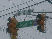
Duclos Lane (Mileposts 0.25–0.74)
The Duclos Lane part of CR 676 is the second longest portion of County Route 676. The border between Edison and Highland Park runs along much of this section. This section also has the second most intersections of the streets that carry the CR 676 designation. The intersection of Duclos Lane and Woodbridge Avenue has no traffic light currently, but Edison mayor Jun ChoiJun Choi
Jun H. Choi is an American politician and the former Mayor of Edison, New Jersey, a community of over 100,000 people and the fifth largest municipality in the state. He was sworn in on January 1, 2006 as the youngest mayor in Edison history...
and the town plan to add a traffic light to relieve congestion.
Lincoln Highway
The Lincoln Highway was the first road across the United States of America.Conceived and promoted by entrepreneur Carl G. Fisher, the Lincoln Highway spanned coast-to-coast from Times Square in New York City to Lincoln Park in San Francisco, originally through 13 states: New York, New Jersey,...
(Route 27), Duclos Lane becomes Suttons Lane, and County Route 676 continues north.
Duclos Lane is named after the Duclos family, who lived in residence 66 at the intersection of what is now Route 27 and Adelaide Avenue in the late 19th century. Edison Township Municipal Code prohibits patrons from parking anywhere on Duclos Lane due to traffic issues.
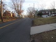
Suttons Lane (Mileposts 0.75–1.55)
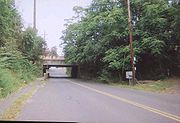
After the second curve is a set of speed bumps which continue until just before the Central Avenue intersection. Just after Central Avenue is a set of baseball fields for the Edison Boys Baseball League named Bobby Brownlie Way. North of the fields is a train culvert for Amtrak
Amtrak
The National Railroad Passenger Corporation, doing business as Amtrak , is a government-owned corporation that was organized on May 1, 1971, to provide intercity passenger train service in the United States. "Amtrak" is a portmanteau of the words "America" and "track". It is headquartered at Union...
's Northeast Corridor
Northeast Corridor
The Northeast Corridor is a fully electrified railway line owned primarily by Amtrak serving the Northeast megalopolis of the United States from Boston in the north, via New York to Washington, D.C. in the south, with branches serving other cities...
. There are two more junctions followed by the southern terminus of County Route 676 at Truman Drive South, just north of the train culvert.
History
In the late 19th century, only the Duclos Lane section of what is now CR 676 had been built, but was not paved; Suttons Lane and Riverview Avenue did not exist at the time. There were also not any housing developments along the road, only farmland. Houses were first built in the area during the 1920s. Approximately 80 residences were built in Highland Park during this time (75 owned, 5 not owned), but all of them were in town and the northernmost residence was on Crowells Lane.The only intersections along Duclos Lane were the Lincoln Highway
Lincoln Highway
The Lincoln Highway was the first road across the United States of America.Conceived and promoted by entrepreneur Carl G. Fisher, the Lincoln Highway spanned coast-to-coast from Times Square in New York City to Lincoln Park in San Francisco, originally through 13 states: New York, New Jersey,...
(present-day Route 27) and Woodbridge Avenue (present-day CR 514), which were then its termini. At the time Duclos Lane was the only connection in Highland Park from between Lincoln Highway and Woodbridge Avenue.
Prior to the 600-series county route designations (1940s and 1950s), the Duclos Lane and Suttons Lane parts of CR 676 was designated as County Route 2S9. The Woodbridge Avenue part was known as County Route 1R2 (present day CR 514), and the Riverview Avenue segment was known as County Route 1R12.