
,_new_york.gif)
Colonie (town), New York
Encyclopedia
- For the original municipality named Colonie, see Arbor Hill, Albany, New York.
Colonie (icon) is a town in Albany County
Albany County, New York
Albany County is a county located in the U.S. state of New York, and is part of the Albany-Schenectady-Troy Metropolitan Statistical Area. The name is from the title of the Duke of York and Albany, who became James II of England . As of the 2010 census, the population was 304,204...
, New York
New York
New York is a state in the Northeastern region of the United States. It is the nation's third most populous state. New York is bordered by New Jersey and Pennsylvania to the south, and by Connecticut, Massachusetts and Vermont to the east...
, United States
United States
The United States of America is a federal constitutional republic comprising fifty states and a federal district...
. It is the most populous suburb
Suburb
The word suburb mostly refers to a residential area, either existing as part of a city or as a separate residential community within commuting distance of a city . Some suburbs have a degree of administrative autonomy, and most have lower population density than inner city neighborhoods...
of Albany, New York
Albany, New York
Albany is the capital city of the U.S. state of New York, the seat of Albany County, and the central city of New York's Capital District. Roughly north of New York City, Albany sits on the west bank of the Hudson River, about south of its confluence with the Mohawk River...
, and is the third largest town in area in Albany County
Albany County, New York
Albany County is a county located in the U.S. state of New York, and is part of the Albany-Schenectady-Troy Metropolitan Statistical Area. The name is from the title of the Duke of York and Albany, who became James II of England . As of the 2010 census, the population was 304,204...
, occupying about 11% of the county. Several hamlets exist within the town. As of the 2010 census, the town had a total population of 81,591. The name is derived from the Dutch Colonye or "Colonie," derived from the Colonie of Rensselaerswyck. All the land outside the Village of Beverwyck (now Albany) was referred to as the "Colonie."
The town of Colonie is north of Albany
Albany, New York
Albany is the capital city of the U.S. state of New York, the seat of Albany County, and the central city of New York's Capital District. Roughly north of New York City, Albany sits on the west bank of the Hudson River, about south of its confluence with the Mohawk River...
, New York, and is at the northern border of the county. Within the town of Colonie are two villages, one also known as Colonie
Colonie (village), New York
Colonie is a village in Albany County, New York, USA. The population was 7,793 at the 2010 census.The village of Colonie is within the town of Colonie...
and the other known as Menands
Menands, New York
Menands is a village in Albany County, New York, United States. The population was 3,990 at the 2010 census. The village is named after Louis Menand...
.
History
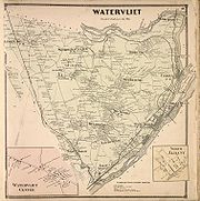
The town of Colonie was formed in 1895 after the rural residents of the town of Watervliet
Watervliet (town), New York
For the Shaker village, see Watervliet Shaker Historic District.The town of Watervliet was a town that at its height encompassed most of present-day Albany County and the majority of the current town of Niskayuna in neighboring Schenectady County, in the state of New York, United States...
opposed the state's proposal to transform the entire town into a city of Watervliet. The town/village of Green Island
Green Island, New York
Green Island is a coterminous town and village in Albany County, New York, USA some 8 miles north of Albany, New York. Green Island is one of only five such town-village amalgams in New York. The population was 2,620 at the 2010 census...
was also split off as a town from the town of Watervliet a year later and the village of West Troy that remained became the current city of Watervliet
Watervliet, New York
Watervliet is a city in Albany County in the US state of New York. The population was 10,254 as of the 2010 census. Watervliet is north of Albany, the capital of the state, and is bordered on the north, west, and south by the town of Colonie. The city is also known as "the Arsenal City".- History...
. All debts from the original town were divided proportionally between Green Island, Watervliet, and Colonie. Several lawsuits worked their way through the court system from the results of division. The original town of Watervliet was the "mother of towns
Timeline of town creation in New York's Capital District
The towns and cities of New York's Capital District were created by the US state of New York as municipalities in order to give residents more direct say over local government. The Capital District is an 11 county area, which consists of the counties of Albany, Schenectady, Rensselaer, Saratoga,...
" in Albany County, having once been all the land outside of the city of Albany within the county, all current towns either were formed directly from Watervliet or from a town formed from Watervliet.
The central part of the town was once the location of the extensive Shaker community farms. The Watervliet Shaker Historic District
Watervliet Shaker Historic District
Watervliet Shaker Historic District, in Colonie, New York, is the site of the first Shaker community. It was established in 1776. The primary Shaker community, the Mount Lebanon Shaker Society, was started a bit later...
is located in Colonie. Much of that land is now occupied by the Albany International Airport
Albany International Airport
Albany International Airport is a public use airport located six nautical miles northwest of the central business district of Albany, in Albany County, New York, United States. It is owned by the Albany County Airport Authority....
.
Through to the 1930s, Colonie was a simple series of extensive farms and a few hamlets. However, in the post-war years, there was intensive suburban development, originally on the corridor that connected Albany and Schenectady, but quickly throughout the entire township. By 1980, suburban development had saturated the community. At the same time, there were large highways (I-87, I-787, US Rt. 9 and NY Rt. 7) constructed which drastically changed the nature of the town and life there. The Colonie of the 1990s and beyond has become an entirely different community from the town of the 1930s and 1940s.
The Supervisor of the Town of Colonie is Democrat Paula Mahan. She was elected to her first term in November 2007, defeating long-time Republican incumbent Mary Brizzell. The Colonie GOP had held the reins of town government since the 1930s. Mahan's upset victory shook the local political scene as one of the great upsets in Albany County electoral history. In November 2009, Mrs. Mahan was re-elected to a second term, defeating former Republican Albany County Executive/former New York State Senator Michael J. Hoblock.
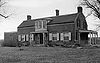
The Casparus F. Pruyn House
Casparus F. Pruyn House
Casparus F. Pruyn House is a historic home located at Colonie in Albany County, New York. It is a two story, rectangular five bay wide, center entrance dwelling in a late Federal / early Greek Revival style. It was built between 1824 and 1836...
is open to the public as the historical and cultural arts center for the Town of Colonie.
Geography
According to the United States Census BureauUnited States Census Bureau
The United States Census Bureau is the government agency that is responsible for the United States Census. It also gathers other national demographic and economic data...
, the town has a total area of 57.9 square miles (149.9 km²). 56.1 square miles (145.2 km²) of it is land and 1.8 square miles (4.7 km²) of it (3.11%) is water.
The north town line borders Schenectady County
Schenectady County, New York
Schenectady County is a county located in the U.S. state of New York. As of the 2010 census, the population was 154,727. It is part of the Albany-Schenectady-Troy Metropolitan Statistical Area. The county seat is Schenectady. The name is from a Mohawk Indian word meaning "on the other side of the...
, and Saratoga County
Saratoga County, New York
Saratoga County is a county located in the U.S. state of New York. As of the 2010 census, the population was 219,607. It is part of the Albany-Schenectady-Troy Metropolitan Statistical Area. The county seat is Ballston Spa...
, marked by the Mohawk River
Mohawk River
The Mohawk River is a river in the U.S. state of New York. It is the largest tributary of the Hudson River. The Mohawk flows into the Hudson in the Capital District, a few miles north of the city of Albany. The river is named for the Mohawk Nation of the Iroquois Confederacy...
. The east town line is the border of Rensselaer County
Rensselaer County, New York
Rensselaer County is a county in the U.S. state of New York. As of the 2010 census, the population was 159,429. Its name is in honor of the family of Kiliaen van Rensselaer, the original Dutch owner of the land in the area. Its county seat is Troy...
, marked by the Hudson River
Hudson River
The Hudson is a river that flows from north to south through eastern New York. The highest official source is at Lake Tear of the Clouds, on the slopes of Mount Marcy in the Adirondack Mountains. The river itself officially begins in Henderson Lake in Newcomb, New York...
. The town lies near the junction of the Hudson and the Mohawk.
Interstate 87
Interstate 87
Interstate 87 is a Interstate Highway located entirely within New York State in the United States of America. I-87 is the longest intrastate Interstate highway in the Interstate Highway System. Its southern end is at the Bronx approaches of the Robert F. Kennedy Bridge in New York City...
, Interstate 787
Interstate 787
Interstate 787 is an auxiliary Interstate Highway in the U.S. state of New York. I-787 is the main highway for those traveling into and out of downtown Albany. The southern terminus is at the Interstate 87/New York State Thruway exit 23 toll plaza southwest of downtown Albany...
, and US Route 9 pass through the town. State Routes 5
New York State Route 5
New York State Route 5 is a state highway that extends for across the state of New York in the United States. It begins at the Pennsylvania state line in the Chautauqua County town of Ripley and passes through Buffalo, Syracuse, Utica, Schenectady, and several other smaller cities and...
, 7
New York State Route 7
New York State Route 7 is a 180-mile long New York State Highway that runs from the New York/Pennsylvania border south of Binghamton, New York to the New York/Vermont border east of Hoosick. Most of the road runs along the Susquehanna Valley, closely paralleling Interstate 88 throughout...
, and 32
New York State Route 32
New York State Route 32 is a north–south state highway that extends for through the Hudson Valley and Capital District regions of the U.S. state of New York. It is a two-lane surface road for nearly its entire length, with few divided and no limited-access sections. From Harriman to Albany,...
are also important arterials within the town.
Location
Demographics
As of the censusCensus
A census is the procedure of systematically acquiring and recording information about the members of a given population. It is a regularly occurring and official count of a particular population. The term is used mostly in connection with national population and housing censuses; other common...
of 2000, there were 79,258 people, 30,980 households, and 20,539 families residing in the town. The population density
Population density
Population density is a measurement of population per unit area or unit volume. It is frequently applied to living organisms, and particularly to humans...
was 1,413.6 inhabitants per square mile (545.8/km²). There were 32,280 housing units at an average density of 575.7 per square mile (222.3/km²). The racial makeup of the town was 90.55% White, 3.96% Black or African American
Race (United States Census)
Race and ethnicity in the United States Census, as defined by the Federal Office of Management and Budget and the United States Census Bureau, are self-identification data items in which residents choose the race or races with which they most closely identify, and indicate whether or not they are...
, 0.15% Native American, 3.59% Asian, 0.02% Pacific Islander, 0.61% from other races
Race (United States Census)
Race and ethnicity in the United States Census, as defined by the Federal Office of Management and Budget and the United States Census Bureau, are self-identification data items in which residents choose the race or races with which they most closely identify, and indicate whether or not they are...
, and 1.13% from two or more races. Hispanic or Latino of any race were 1.86% of the population.
There were 30,980 households out of which 29.2% had children under the age of 18 living with them, 53.3% were married couples
Marriage
Marriage is a social union or legal contract between people that creates kinship. It is an institution in which interpersonal relationships, usually intimate and sexual, are acknowledged in a variety of ways, depending on the culture or subculture in which it is found...
living together, 9.6% had a female householder with no husband present, and 33.7% were non-families. 28.1% of all households were made up of individuals and 11.1% had someone living alone who was 65 years of age or older. The average household size was 2.43 and the average family size was 3.00.
In the town the population was spread out with 21.8% under the age of 18, 8.9% from 18 to 24, 27.8% from 25 to 44, 25.1% from 45 to 64, and 16.3% who were 65 years of age or older. The median age was 40 years. For every 100 females there were 92.8 males. For every 100 females age 18 and over, there were 89.6 males.
The median income for a household in the town was $51,817, and the median income for a family was $62,649. Males had a median income of $41,453 versus $30,763 for females. The per capita income
Per capita income
Per capita income or income per person is a measure of mean income within an economic aggregate, such as a country or city. It is calculated by taking a measure of all sources of income in the aggregate and dividing it by the total population...
for the town was $25,231. About 3.0% of families and 4.7% of the population were below the poverty line, including 4.5% of those under age 18 and 6.0% of those age 65 or over.
Public safety
Law enforcement in the town is primarily provided by the Town of Colonie Police Department and Village of Menands Police Department. However, that law enforcement is supplemented by the New York State Police Troop G (the headquarters of which lies within the town of Colonie), and the Albany County Sheriff's Office which patrols the Albany International Airport and operates the Albany County Correctional Facilities (which also lie within the town of Colonie). In November 2007, the town of Colonie was ranked the sixth safest place to live in a Morgan Quitno Publishing study of crime rates across the United States. On November 23, 2009, CQ Press ranked the town of Colonie with the lowest crime rate of all communities in the United States with a population of at least 75,000 residents. On November 22, 2010, CQ Press again ranked the town of Colonie with the lowest crime rate of all communities in the United States with a population of at least 75,000 residents.Emergency Medical Service (advanced, basic, and transport) in the town is primarily provided by the Town of Colonie Emergency Medical Services Department. The EMS Department also serves as an integral part of any heavy or light rescue operations in the town. In 1999, the town of Colonie Emergency Medical Services Department was awarded the National Association of Emergency Medical Technicians
National Association of Emergency Medical Technicians
The National Association of Emergency Medical Technicians ' is a national Emergency medical services professional association representing all EMTs and Paramedics....
' National Paramedic Service of the Year Award. The award is given to one service of high distinction that has demonstrated excellence, innovation and community service. Previous award recipients had been EMS agencies in Tampa, Kansas City, St. Louis, and Houston. On May 4, 2010, the town of Colonie was awarded the 2010 International Association of Fire Chief’s “Heartsafe Community” award for making significant advances in emergency cardiac care. There are two awards given each year, one for large communities (over 100,000 in population) and one for a small communities (under 100,000 in population). Colonie was tapped for the small community honor and Anchorage, Alaska
Anchorage, Alaska
Anchorage is a unified home rule municipality in the southcentral part of the U.S. state of Alaska. It is the northernmost major city in the United States...
was tapped for the large community honor. On August 28, 2010, the New York State EMS Council awarded the town of Colonie Emergency Medical Services Department the New York State "EMS Agency of the Year" award.
Firefighting service in the town is primarily provided by one of twelve (mostly volunteer) firefighting agencies and one paid fire brigade. (See also Administrative divisions of New York
Administrative divisions of New York
The administrative divisions of New York are the various units of government that provide local government services in the state of New York. The state has four types of multi-purpose municipal corporation that provide most local government services, namely: counties, cities, towns, and villages...
.)
- Five Fire Districts (Boght Community, Midway, Schuyler Heights, Verdoy, and West Albany).
- One Joint Fire District (Stanford Heights).
- Four Fire Protection Districts (Fuller Road, Latham, Maplewood, and Shaker Road-Loudonville).
- Two Village Fire Departments (Colonie and Menands).
These agencies encompass thirteen fire companies (West Albany Fire District has two companies), seventeen fire stations, two small rescue boats (Boght & Verdoy), six ladder trucks (Fuller Road, Latham, Menands, Midway, Schuyler Heights, and Shaker Road-Loudonville), one Hazardous Materials Specialty Rescue (West Albany), one Trench/Structural Collapse Specialty Rescue (Village of Colonie), one Confined Space Specialty Rescue (Latham), eight General/Light Rescue apparatus, numerous full-size pumpers, a small number of attack pumpers, and a small number of EMS First-Response vehicles.
- One Paid Fire Brigade
The Albany International Airport Fire Brigade consists of a full-time paid crash/fire/rescue staff, three crash/rescue vehicles, a mini pumper, hazmat truck, foam re-supply truck, and a full-size pumper. However, the airport's fire units stay on Airport Authority property most of the time, and are housed in yet another fire station that is on the Airport Authority's property. Occasionally, the Airport Fire Brigade responds to mutual aid requests with the bordering Shaker Road-Loudonville Fire Department, as well as other fire agencies within the town of Colonie and Albany County.
- Also located in the town of Colonie is a "FEMA Urban Search and Rescue (USAR) Team" New York Task Force 2 (NY-TF2). NY-TF2 (then known as the New York Regional Response Team-1 {NYRRT-1}) was the first USAR team on site immediately following the collapse of the World Trade Center because many members of NY-TF1Urban Search and Rescue New York Task Force 1Urban Search and Rescue New York Task Force 1 or NY-TF1 is a FEMA Urban Search and Rescue Task Force based in New York City, New York. NY-TF1 is jointly sponsored by the Fire Department of New York and the New York City Police Department....
(based in New York City) were members of the FDNY that perished in the collapse. Those same members provided much of the initial training to NY-TF2.
Education
There are four public school districts that serve the town of Colonie, the South Colonie Central School District, North Colonie Central SchoolsNorth Colonie Central Schools
North Colonie Central Schools is a public school district located in Colonie, New York.-Merger with Maplewood-Colonie Common School District:In October 2007, the annexation of Maplewood-Colonie Common School District with the North Colonie Central School District was approved, 1446 yes to 277 no,...
, Watervliet City School District
Watervliet, New York
Watervliet is a city in Albany County in the US state of New York. The population was 10,254 as of the 2010 census. Watervliet is north of Albany, the capital of the state, and is bordered on the north, west, and south by the town of Colonie. The city is also known as "the Arsenal City".- History...
, and Menands Union Free School District. South Colonie (Colonie Central High School
Colonie Central High School
Colonie Central High School is a public high school in the town of Colonie, with the postal address of Albany, New York. In 2005 it had 2225 students and 132 classroom teachers. It is part of the South Colonie Central School District. The building principal is David Wetzel.-Athletics:The school...
) serves much of the western part of the town, including West Albany, the village of Colonie, and a small part of the adjoining town of Niskayuna. North Colonie (Shaker High School
Shaker High School
Shaker High School is a public high school in Latham, Albany County, New York, and is part of the North Colonie Central School District. , it has an enrollment of over 2100 students. In 1985, it was recognized as an Exemplary School by the United States Department of Education, one of the first to...
) serves Latham and the smaller, suburban and rural hamlets to the north of Latham, as well as most of Loudonville and Newtonville. The Watervliet City School District (Watervliet High School) serves some students from Menands and the Schuyler Heights area. The Menands Union Free School District is a single building school district serving the village of Menands and educates students from kindergarten through eighth grade. Upon completion of eighth grade, Menands Union Free School District students choose from a list (developed by the Menands UFSD) of local high schools to attend. In 2008, a fifth public school district, the Maplewood-Colonie Common School District, merged with-and-into the North Colonie School District.
The town of Colonie is also home to the Christian Brothers
Christian Brothers
Christian Brothers may refer to:* Congregation of Christian Brothers, a Catholic lay order founded at Waterford, Ireland in 1802 by the Blessed Edmund Ignatius Rice...
Academy of Albany, NY.
Siena College
Siena College
Siena College is an independent Roman Catholic liberal arts college in Loudonville, in the town of Colonie, New York, United States. Siena is a four-year, coeducational, independent college in the Franciscan tradition, founded by the Franciscan Friars in 1937. It has 3,000 full-time students and...
, a private-liberal arts college
Liberal arts college
A liberal arts college is one with a primary emphasis on undergraduate study in the liberal arts and sciences.Students in the liberal arts generally major in a particular discipline while receiving exposure to a wide range of academic subjects, including sciences as well as the traditional...
, is located in the hamlet of Newtonville/Loudonville.
Bryant & Stratton College, Mildred Elly College, and ITT Technical Institute, all proprietary colleges, have campuses in the town of Colonie.
Media
There are two dedicated weekly newspapers for parts of the town, the Colonie Spotlight and Loudonville Spotlight. Also, Channel 17 on Time Warner CableTime Warner Cable
Time Warner Cable is an American cable television company that operates in 28 states and has 31 operating divisions...
in the town is a Public-access television
Public-access television
Public-access television is a form of non-commercial mass media where ordinary people can create content television programming which is cablecast through cable TV specialty channels...
station devoted to town news, programming, and events. The studios are located inside the town library.
Although not dedicated to the town of Colonie, the offices and distribution center for the major daily local newspaper, Albany Times Union (owned by the Hearst Corporation)
Hearst Corporation
The Hearst Corporation is an American media conglomerate based in the Hearst Tower, Manhattan in New York City, New York, United States. Founded by William Randolph Hearst as an owner of newspapers, the company's holdings now include a wide variety of media...
, lies within the town.
The town was the site of the fourth season finale of Extreme Makeover: Home Edition
Extreme Makeover: Home Edition
Extreme Makeover: Home Edition is a reality television series providing home renovations for less fortunate families and community schools etc...
in 2007. Many businesses in the Capital District
Capital District
New York's Capital District, also known as the Capital Region, is a region in upstate New York that generally refers to the four counties surrounding Albany, the capital of the state: Albany County, Schenectady County, Rensselaer County, and Saratoga County...
contributed to building a new home for the Oatman-Gaitan Family, consisting of a mother with three adopted children, two of whom were HIV-positive.
Communities and locations
- Albany International AirportAlbany International AirportAlbany International Airport is a public use airport located six nautical miles northwest of the central business district of Albany, in Albany County, New York, United States. It is owned by the Albany County Airport Authority....
(ALB) -- An airport servicing Albany and the region; technically the airport is in LathamLatham, New YorkLatham is a hamlet in Albany County, New York, United States. It is located along U.S. Route 9 in the town of Colonie, a dense suburb north of Albany.-History:... - Boght CornersBoght Corners, New YorkBoght Corners is a hamlet in the town of Colonie in northern Albany County, New York that straddles U.S. Route 9 . The corners that give the hamlet its name are found at the intersection of Route 9 and Boght Road , near the Boght Community Fire District’s station...
-- A hamlet in the northeast part of the town. - ColonieColonie (village), New YorkColonie is a village in Albany County, New York, USA. The population was 7,793 at the 2010 census.The village of Colonie is within the town of Colonie...
-- An incorporated village. - Crescent StationCrescent Station, New YorkCrescent Station is a hamlet of the town of Colonie in Albany County, New York that straddles US Route 9.-History:Crescent Station takes its name from a stop on the Schenectady and Troy Railroad , later a branch of the New York Central Railroad. The T&S Line was completed in 1842, and owned by the...
-- A hamlet at the northernmost point of the town of Colonie. - KarnerKarner, New YorkKarner is a hamlet of the town of Colonie, Albany County, New York. Once called Center Station it was a stop along the New York Central Railroad that became famous for being the site where the Karner Blue butterfly was first identified.-History:...
-- A hamlet southwest of the village of Colonie. - Dunsbach FerryDunsbach Ferry, New YorkDunsbach Ferry is a hamlet of the town of Colonie, in Albany County, New York. The hamlet sits to the east of, and below, the Thaddeus Kosciusko Bridge , where Interstate 87 crosses the Mohawk River. There are numerous private and public docks and landings between the Twin Bridges and the Colonie...
-- A hamlet in the northwest part of the town at the Mohawk River. - LathamLatham, New YorkLatham is a hamlet in Albany County, New York, United States. It is located along U.S. Route 9 in the town of Colonie, a dense suburb north of Albany.-History:...
-- A hamlet near the center of the town. - Lisha KillLisha Kill, New YorkLisha Kill is a hamlet in the town of Colonie, Albany County, New York. Lisha Kill lies on New York Route 5 in the western section of the town. The hamlet received its name from the creek of the same name, Lisha Kill, kill being Dutch for creek or stream...
-- A hamlet on the in the northwest section of town, on Route 5. - LoudonvilleLoudonville, New YorkLoudonville is a hamlet in the town of Colonie, in Albany County, New York, United States. Loudonville was a census-designated place in the 1970, 1980, and 1990 US Census, but ceased to be in the 2000 Census.The area is not precisely defined...
-- A suburban hamlet near the city line of Albany. - MannsvilleMannsville, Albany County, New YorkMannsville is a hamlet within the town of Colonie, Albany County, New York. It is a small community west of the city of Watervliet and is inaccessible to the rest of Colonie by car without driving through Watervliet first...
-- Part of the Schuyler Heights Fire District and Watervliet City School District. - Maplewood -- A hamlet adjacent to Cohoes, Watervliet and Green Island.
- Maywood -- A hamlet northwest of Colonie village on Route 5.
- MenandsMenands, New YorkMenands is a village in Albany County, New York, United States. The population was 3,990 at the 2010 census. The village is named after Louis Menand...
-- An incorporated village in the eastern part of town. - NewtonvilleNewtonville, New YorkNewtonville is a hamlet in the town of Colonie in Albany County, New York, United States. Located along U.S. Route 9, the hamlet is just south of Latham and north of Loudonville. Colonie Town Hall is located in the hamlet of Newtonville.-History:...
-- A hamlet between Latham and Loudonville. - Schuyler Heights -- A hamlet north of MenandsMenands, New YorkMenands is a village in Albany County, New York, United States. The population was 3,990 at the 2010 census. The village is named after Louis Menand...
; south and west of WatervlietWatervliet, New YorkWatervliet is a city in Albany County in the US state of New York. The population was 10,254 as of the 2010 census. Watervliet is north of Albany, the capital of the state, and is bordered on the north, west, and south by the town of Colonie. The city is also known as "the Arsenal City".- History...
; east of LoudonvilleLoudonville, New YorkLoudonville is a hamlet in the town of Colonie, in Albany County, New York, United States. Loudonville was a census-designated place in the 1970, 1980, and 1990 US Census, but ceased to be in the 2000 Census.The area is not precisely defined...
; lying on the west bank of the Hudson RiverHudson RiverThe Hudson is a river that flows from north to south through eastern New York. The highest official source is at Lake Tear of the Clouds, on the slopes of Mount Marcy in the Adirondack Mountains. The river itself officially begins in Henderson Lake in Newcomb, New York...
. Part of the Schuyler Heights Fire District and Watervliet City School District and North Colonie School DistrictNorth Colonie Central SchoolsNorth Colonie Central Schools is a public school district located in Colonie, New York.-Merger with Maplewood-Colonie Common School District:In October 2007, the annexation of Maplewood-Colonie Common School District with the North Colonie Central School District was approved, 1446 yes to 277 no,...
. - RoesslevilleRoessleville, New YorkRoessleville is a hamlet in the town of Colonie, Albany County, New York. It is a densely settled suburb of the city of Albany along New York State Route 5...
-- A suburban community near the city line of Albany - ShakersWatervliet Shaker Historic DistrictWatervliet Shaker Historic District, in Colonie, New York, is the site of the first Shaker community. It was established in 1776. The primary Shaker community, the Mount Lebanon Shaker Society, was started a bit later...
-- A settlement southwest of Albany Airport. - Stanford Heights -- A hamlet on the west town line with Schenectady County.
- VerdoyVerdoy, New YorkVerdoy, formerly known as Watervliet Center, is a hamlet of the town of Colonie in Albany County, New York. Much of Verdoy is in the Airport Noise Overlay District due to its immediate proximity to Albany International Airport's main north/south runway, which was recently extended by 1,300 feet to...
-- A hamlet north of Albany airport. - West AlbanyWest Albany, New YorkWest Albany is a hamlet in the town of Colonie, Albany County, New York. Parts of the neighboring city of Albany around Watervliet Avenue Extension and Industrial Park Road are also considered part of West Albany and includes the majority of the West Albany Rail Yard...
-- A hamlet on the southern edge of the town, along the city line of Albany.