

Clintonville
Encyclopedia
Columbus, Ohio
Columbus is the capital of and the largest city in the U.S. state of Ohio. The broader metropolitan area encompasses several counties and is the third largest in Ohio behind those of Cleveland and Cincinnati. Columbus is the third largest city in the American Midwest, and the fifteenth largest city...
, USA with around 30,000 residents. Clintonville is an informal neighborhood. The southern border is loosely defined as Arcadia Avenue or the Glen Echo Ravine. To the east, either I-71 or the adjacent railroad tracks are commonly accepted. The western boundary is assumed to be the Olentangy River
Olentangy River
The Olentangy River is a tributary of the Scioto River in Ohio.It was originally called keenhongsheconsepung, a Delaware word literally translated as "stone for your knife stream", based on the shale found along its shores. Early settlers to the region translated this into "Whetstone River"...
. The northern border of Clintonville is the most ambiguous, with definitions anywhere in the 3 mi (4.8 km) stretch from Cooke Road to the southern border of Worthington
Worthington, Ohio
-Dissolution of the Company:By August 11, 1804 the plat maps were completed, payments or notes promising payments collected and deeds prepared for all sixteen thousand acres of the Scioto Company's purchase...
. The Clintonville Area Commission boundaries, as established by Columbus City Code, are "bounded on the south by the centerline of the Glen Echo Ravine; on the east by the centerline of the railroad right-of-way immediately east of Indianola Avenue; on the north by the Worthington city limits and on the west by the Olentangy River; each line extended as necessary so as to intersect with adjacent boundaries".
As the cachet of the Clintonville neighborhood grew towards the turn of the 21st century, real estate agents began to label homes north of Cooke Road as being in Clintonville, leading to the apparent absorption of Beechwold and nearby neighborhoods south of Worthington
Worthington, Ohio
-Dissolution of the Company:By August 11, 1804 the plat maps were completed, payments or notes promising payments collected and deeds prepared for all sixteen thousand acres of the Scioto Company's purchase...
. It was not uncommon in the booming real estate market circa 2000 to even find homes outside of the distinct east and west borders being sold as "Clintonville" homes. Because Clintonville and Beechwold have no official existence, however, the boundaries are a matter of opinion. The area also contains the former unincorporated community of Evanston, a name that was used by the Big Four Railroad as a station along its line and U.S. Postal service until the 1920s. Clintonville includes parts of ZIP codes 43202 and 43214. The United States Post Offices at the center of each ZIP code are known as Clintonville Station and Beechwold Station, respectively.
History
The community of Clintonville developed as the center of Clinton TownshipClinton Township, Franklin County, Ohio
Clinton Township is one of the nineteen townships of Franklin County, Ohio, United States. The 2000 census found 4,294 people in the township.-Geography:...
(named for the U.S. Vice President
Vice President of the United States
The Vice President of the United States is the holder of a public office created by the United States Constitution. The Vice President, together with the President of the United States, is indirectly elected by the people, through the Electoral College, to a four-year term...
George Clinton
George Clinton (vice president)
George Clinton was an American soldier and politician, considered one of the Founding Fathers of the United States. He was the first Governor of New York, and then the fourth Vice President of the United States , serving under Presidents Thomas Jefferson and James Madison. He and John C...
), part of the land grants
United States Military District
The United States Military District was a land tract in central Ohio that was established by the Congress to compensate veterans of the American Revolutionary War for their service...
given to Continental Army
Continental Army
The Continental Army was formed after the outbreak of the American Revolutionary War by the colonies that became the United States of America. Established by a resolution of the Continental Congress on June 14, 1775, it was created to coordinate the military efforts of the Thirteen Colonies in...
soldiers in lieu of pensions in what used to be Wyandotte Indian territory. For years, the steep hillsides discouraged development, until farmland was purchased by the Bull family and then used for religious services. Clinton Chapel (now a funeral home) was constructed in 1838 and served as a stop on the Underground Railroad
Underground Railroad
The Underground Railroad was an informal network of secret routes and safe houses used by 19th-century black slaves in the United States to escape to free states and Canada with the aid of abolitionists and allies who were sympathetic to their cause. The term is also applied to the abolitionists,...
over the next two decades.
In an attempt to draw others to the area and lessen the isolation of their farm, the Bulls built businesses in the center of Clinton Township, along the plank toll road that later became High Street, the main north-south thoroughfare connecting Columbus to Worthington, Ohio
Worthington, Ohio
-Dissolution of the Company:By August 11, 1804 the plat maps were completed, payments or notes promising payments collected and deeds prepared for all sixteen thousand acres of the Scioto Company's purchase...
to the north. They offered to give these buildings away to any skilled laborers who would stay. A post office designated "Clintonville" opened in the center of this district on September 13, 1847, and this date is marked by present-day Clintonville residents as the neighborhood's "birthday".
By the early 1900s, downtown Columbus residents and professors from Ohio State University
Ohio State University
The Ohio State University, commonly referred to as Ohio State, is a public research university located in Columbus, Ohio. It was originally founded in 1870 as a land-grant university and is currently the third largest university campus in the United States...
had built summer homes in Clintonville, and the surrounding farmland was developed into housing developments shortly after the extension of the streetcar lines northward from Columbus. A business district developed in Beechwold, separated by nearly a mile of residences from the Clintonville district to the south. Both communities were entirely part of Columbus by the 1950s, after it annexed most of Clinton Township.
Governance
Because Columbus City Council does not use a ward system of representative government (all members of city council are elected at-large) the city created a series of Area Commissions to act in an advisory capacity to the city in reviewing zoning, variance, and demolition requests. The Clintonville and Beechwold neighborhoods, along with other Northern Columbus neighborhoods are represented by the Clintonville Area Commission. The nine district-representative Commissioners of the Commission are nominated by neighborhood elections - with the Commissioners being subsequently subject to appointment by the Columbus Mayor and affirmation by the Columbus City Council. The Old Beechwold subdivision is further subject to an architectural review process.Since 2004, residents along the southern ridge of Glen Echo Ravine have been seeking to have their neighborhood represented by the Clintonville Area Commission rather than by the University Area Commission, citing the view that their needs more closely match those of Clintonville residents than those of the University Area. While there currently is not a process for accommodating such requests, their request has caught the attention of city leaders who are examining the whole Area Commission program.
Neighborhoods
The topographyTopography
Topography is the study of Earth's surface shape and features or those ofplanets, moons, and asteroids...
of Clintonville is divided into two distinct regions, with High Street forming the demarcation line. Property west of High Street to the Olentangy River is lower in elevation than property to east of High Street. Six glacial ravines, Glen Echo, Walhalla, Overbrook, Beechwold, Delawanda and Bill Moose Run cut through the area from east to west, with stream beds feeding into the Olentangy River. Four of the Ravines have been developed, either with public roadbeds and/or private residences, with Glen Echo being the first ravine preserved as a public park in 1913. A portion of Overbrook Ravine is part of Whetstone Park, adjacent to the Park of Roses.
Residential districts in Clintonville are divided into four distinct (and unofficial) areas:
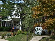
- South Clintonville - South of North Broadway, housing stock is a mix of single and multiple family homes. The majority of these houses were built prior to 1930, and represent a variety of styles from basic American four-square to other types of revival style architecture. The area is also home to many catalogue (SearsSears, Roebuck and CompanySears, officially named Sears, Roebuck and Co., is an American chain of department stores which was founded by Richard Warren Sears and Alvah Curtis Roebuck in the late 19th century...
, Montgomery WardMontgomery WardMontgomery Ward is an online retailer that carries the same name as the former American department store chain, founded as the world's #1 mail order business in 1872 by Aaron Montgomery Ward, and which went out of business in 2001...
, Radford, etc.) kit homes. These neighborhoods were also initially developed as “streetcar” developments, the intention being that most residents would rely upon the High Street streetcar lines to travel to downtown Columbus. Garages for the earliest developed streets are accessed via alleys behind the properties.
- North Clintonville – Immediately north of North Broadway and stretching to the Overbrook Ravine, this central section of Clintonville shows the progression in architectural styles and lifestyle considerations from the 1920s through the late 1950s. Houses in this portion of Clintonville were built as higher end properties, lack alleyways and contain driveways as a nod to the increasing importance to the role of the automobile.
- Beechwold – Named for the Jeffrey family summer estate on N. High Street, Beechwold contains the widest variety of housing, from Cape Cod influenced starter homes to high style, high end housing that occupies the land comprising the former Jeffrey family estate.
- North of Morse - North of Morse Rd and extending north to the Worthington city limits. This area is home to Bill Moose Run, the recently refurbished Graceland Shopping Center, the Ohio School for the Deaf and the Ohio State School for the Blind. A new park has recently been created at the site of the former Sharon Elementary School.
Streets
Like many of the neighborhoods in Columbus, the streets were often named after either early settlers or areas of Great BritainGreat Britain
Great Britain or Britain is an island situated to the northwest of Continental Europe. It is the ninth largest island in the world, and the largest European island, as well as the largest of the British Isles...
. However, the streets in the Walhalla Park Place section of Clintonville bear the legacy of Mathias Armbruster, a Bavaria
Bavaria
Bavaria, formally the Free State of Bavaria is a state of Germany, located in the southeast of Germany. With an area of , it is the largest state by area, forming almost 20% of the total land area of Germany...
n immigrant who was fascinated with Norse mythology
Norse mythology
Norse mythology, a subset of Germanic mythology, is the overall term for the myths, legends and beliefs about supernatural beings of Norse pagans. It flourished prior to the Christianization of Scandinavia, during the Early Middle Ages, and passed into Nordic folklore, with some aspects surviving...
and Wagnerian
Richard Wagner
Wilhelm Richard Wagner was a German composer, conductor, theatre director, philosopher, music theorist, poet, essayist and writer primarily known for his operas...
opera; these street names include Druid
Druid
A druid was a member of the priestly class in Britain, Ireland, and Gaul, and possibly other parts of Celtic western Europe, during the Iron Age....
, Mimring, Midgard
Midgard
Midgard is one of the Nine Worlds and is an old Germanic name for our world and is the home of Humans, with the literal meaning "middle enclosure".-Etymology:...
, Brynhild, Gudrun
Gudrun
Gudrun is a major figure in the early Germanic literature centered on the hero Sigurd, son of Sigmund. She appears as Kriemhild in the Nibelungenlied and as Gutrune in Wagner's Der Ring des Nibelungen.-Norse mythology:...
, and Walhalla
Valhalla
In Norse mythology, Valhalla is a majestic, enormous hall located in Asgard, ruled over by the god Odin. Chosen by Odin, half of those that die in combat travel to Valhalla upon death, led by valkyries, while the other half go to the goddess Freyja's field Fólkvangr...
.
Landmarks
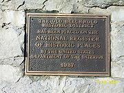
Popular landmarks in Clintonville include the "Welcome to Clintonville" signs at the main entryways of the community, Immaculate Conception church and Hagley Field, on lease from the Columbus City Schools for Bishop Watterson High School to use as its home field, previously utilized as such by Columbus North High School that closed as a normal high school and re-opened as a vocational school before becoming the temporary home of Columbus East High School students as their school is remodeled.A commemorative historical marker for Clinton Township and Clintonville is now at the N. High Street entrance driveway to the Clintonville Women's Club, the sign originally having been at the corner of E. North Broadway and High Street - a mile south of the present location.
Whetstone Park
Whetstone Park in Clintonville is a Columbus landmark. The Park includes bike trails, baseball fields and tennis courts, a pond, ravine, library and recreation facility, as well as the beautiful 13 acre (52,609.2 m²) Park of Roses. Opened in 1952, the Park of Roses is a frequent site for weddings and special events. In June the Park of Roses hosts its annual "Rose Festival." During summer months concerts featuring many of Columbus' brass bands are held every Sunday evening at the Park's gazebo. Originally located at Fort HayesFort Hayes
Fort Hayes, a military post in Columbus, Ohio, United States, was created by an act of the United States Congress in 1877. As of 2007, the property is primarily used for the Columbus School District's Fort Hayes Metropolitan Education Center and bus depot. Currently, the 391st Military Police...
, the gazebo was relocated to the Park and restored in 1976. Whetstone Park also hosts an annual Fourth of July
Independence Day (United States)
Independence Day, commonly known as the Fourth of July, is a federal holiday in the United States commemorating the adoption of the Declaration of Independence on July 4, 1776, declaring independence from the Kingdom of Great Britain...
fireworks display for the Clintonville community, perhaps the largest in Columbus aside from the downtown display, Red, White & Boom.
Olentangy Park
Clintonville was once home to the largest amusement park in the United StatesUnited States
The United States of America is a federal constitutional republic comprising fifty states and a federal district...
. First opened in 1880 as "The Villa," by 1900 the 100 acre (0.404686 km²) park and picnic ground had become Olentangy Park
Olentangy Park
Formerly located in Columbus, Ohio in the area of Clintonville, in the early years of the 20th century Olentangy Park was the largest amusement park in the United States.-The 1880 to 1899 "The Villa":...
. This park, located along N. High Street between North Street and Tulane Road, grew rapidly between 1900 and 1915, and at one time featured four large roller coaster
Roller coaster
The roller coaster is a popular amusement ride developed for amusement parks and modern theme parks. LaMarcus Adna Thompson patented the first coasters on January 20, 1885...
s, including a rare looping coaster known as the "Loop-the-Loop", a zoo
Zoo
A zoological garden, zoological park, menagerie, or zoo is a facility in which animals are confined within enclosures, displayed to the public, and in which they may also be bred....
, a dance pavilion, a large "Shoot-the-Chutes" water slide, and a building from which visitors could rent canoes for a day on the Olentangy River. It was also home to the largest theatre in the country, as well as the largest swimming pool in the world at the time. Olentangy Park
Olentangy Park
Formerly located in Columbus, Ohio in the area of Clintonville, in the early years of the 20th century Olentangy Park was the largest amusement park in the United States.-The 1880 to 1899 "The Villa":...
closed in 1939 and the land was used to build the Olentangy Village apartment complex; scattered remains of the park could still be found in the woods by the river as recently as the late 1980s. The park's carousel
Carousel
A carousel , or merry-go-round, is an amusement ride consisting of a rotating circular platform with seats for riders...
was moved several times and in 1999 it was restored. This carousel can now be seen at the Columbus Zoo and Aquarium
Columbus Zoo
The Columbus Zoo and Aquarium is a non-profit zoo located in Powell, Ohio , just north of Columbus. The land lies along the eastern banks of the O'Shaughnessy Reservoir on the Scioto River, at the intersection of Riverside Drive and Powell Road...
.