

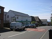
Cleehill
Encyclopedia
Shropshire
Shropshire is a county in the West Midlands region of England. For Eurostat purposes, the county is a NUTS 3 region and is one of four counties or unitary districts that comprise the "Shropshire and Staffordshire" NUTS 2 region. It borders Wales to the west...
, England
England
England is a country that is part of the United Kingdom. It shares land borders with Scotland to the north and Wales to the west; the Irish Sea is to the north west, the Celtic Sea to the south west, with the North Sea to the east and the English Channel to the south separating it from continental...
. It is sometimes written as Clee Hill Village (including the road sign entering the village) to avoid confusion.
It lies on the slope of Titterstone Clee Hill
Titterstone Clee Hill
Titterstone Clee Hill, sometimes referred to as Clee Hill or Titterstone Clee, is a hill in the rural English county of Shropshire, rising at the summit to 533 m above sea level....
and, lying between 340 and 380 metres above sea level
Sea level
Mean sea level is a measure of the average height of the ocean's surface ; used as a standard in reckoning land elevation...
, it is one of the highest settlements in the county and has Shropshire's highest public house
Public house
A public house, informally known as a pub, is a drinking establishment fundamental to the culture of Britain, Ireland, Australia and New Zealand. There are approximately 53,500 public houses in the United Kingdom. This number has been declining every year, so that nearly half of the smaller...
(at 395m) (named "The Kremlin") and Shropshire's highest schoolhttp://www.geograph.org.uk/photo/267616.
The A4117
A4117 road
The A4117 is a major road in England. It branches from the A456 west of Bewdley, and runs westward to Ludlow via Cleobury Mortimer and Cleehill. The pass over Titterstone Clee Hill reaches an altitude of 381 metres, making the A4117 Shropshire's highest A-road...
runs through the village and there is a cattle grid stretching over this major thoroughfare due to the road running across common land
Common land
Common land is land owned collectively or by one person, but over which other people have certain traditional rights, such as to allow their livestock to graze upon it, to collect firewood, or to cut turf for fuel...
. The road reaches an altitude of 381 metres as it passes
Mountain pass
A mountain pass is a route through a mountain range or over a ridge. If following the lowest possible route, a pass is locally the highest point on that route...
Titterstone Clee Hill just to the east of the village, and is often affected by snow
Snow
Snow is a form of precipitation within the Earth's atmosphere in the form of crystalline water ice, consisting of a multitude of snowflakes that fall from clouds. Since snow is composed of small ice particles, it is a granular material. It has an open and therefore soft structure, unless packed by...
in winter.