

Cherry Orchard Road
Encyclopedia
Croydon
Croydon is a town in South London, England, located within the London Borough of Croydon to which it gives its name. It is situated south of Charing Cross...
, London
London
London is the capital city of :England and the :United Kingdom, the largest metropolitan area in the United Kingdom, and the largest urban zone in the European Union by most measures. Located on the River Thames, London has been a major settlement for two millennia, its history going back to its...
. The street is part of the longer A222 road
A222 road
The A222 is a non-primary A road between Bexley and Croydon. The road passes through three London boroughs.-Route:The A222 starts in the narrow Bexley High Street, which has a great deal of character. It passes Bexley railway station and the B2210, then it carries on along the train lines until it...
for all of its length. This road carries on to Old Bexley and passes a major junction with the A20 dual-carriageway to Central London
Central London
Central London is the innermost part of London, England. There is no official or commonly accepted definition of its area, but its characteristics are understood to include a high density built environment, high land values, an elevated daytime population and a concentration of regionally,...
and Dover
Dover
Dover is a town and major ferry port in the home county of Kent, in South East England. It faces France across the narrowest part of the English Channel, and lies south-east of Canterbury; east of Kent's administrative capital Maidstone; and north-east along the coastline from Dungeness and Hastings...
, and the A21 road with connections with Hastings
Hastings
Hastings is a town and borough in the county of East Sussex on the south coast of England. The town is located east of the county town of Lewes and south east of London, and has an estimated population of 86,900....
and Lewisham
Lewisham
Lewisham is a district in South London, England, located in the London Borough of Lewisham. It is situated south-east of Charing Cross. The area is identified in the London Plan as one of 35 major centres in Greater London.-History:...
.
The road joins Addiscombe
Addiscombe
Addiscombe is a district of south London, England, located in the London Borough of Croydon. It is situated south of Charing Cross.It is situated just to the northeast of central Croydon, and is home to a high proportion of people who commute to Central London, owing to its proximity to the busy...
with East Croydon
Croydon
Croydon is a town in South London, England, located within the London Borough of Croydon to which it gives its name. It is situated south of Charing Cross...
, and is a vital link to the major transport interchange of East Croydon station
East Croydon station
East Croydon station is a railway station and tram stop in Croydon, 10.35 miles south of London Bridge in Travelcard Zone 5. It is the largest and busiest station in Croydon and the busiest in London outside Travelcard Zone 1 in terms of the number of passengers entering and exiting...
where there are overground services
Rail transport
Rail transport is a means of conveyance of passengers and goods by way of wheeled vehicles running on rail tracks. In contrast to road transport, where vehicles merely run on a prepared surface, rail vehicles are also directionally guided by the tracks they run on...
and Tramlink
Tramlink
Tramlink is a tramway system in south London in the United Kingdom which began operation in May 2000...
services on all routes. The station provides mainline services from Southern
Southern (train operating company)
Southern is a train operating company in the United Kingdom. Officially named Southern Railway Ltd., it is a subsidiary of Govia, a joint venture between transport groups Go-Ahead Group and Keolis, and has operated the South Central rail franchise since October 2000 and the Gatwick Express service...
, Southeastern
Southeastern (train operating company)
London & South Eastern Railway Limited, trading as Southeastern is a train operating company in south-east England. On 1 April 2006 it became the franchisee for the new Integrated Kent Franchise , replacing the publicly owned South Eastern Trains on the former South East Franchise...
, First Capital Connect
First Capital Connect
First Capital Connect is a passenger train operating company in England that began operations on the National Rail network on 1 April 2006...
and CrossCountry
CrossCountry
CrossCountry is the brand name of XC Trains Ltd., a British train operating company owned by Arriva...
, formerly Virgin Trains
Virgin Trains
Virgin Trains is a train operating company in the United Kingdom. It operates long-distance passenger services on the West Coast Main Line between London, the West Midlands, North West England, North Wales and Scotland...
. These train operating companies provide services to the South Coast
Southern England
Southern England, the South and the South of England are imprecise terms used to refer to the southern counties of England bordering the English Midlands. It has a number of different interpretations of its geographic extents. The South is considered by many to be a cultural region with a distinct...
, Bedford
Bedford
Bedford is the county town of Bedfordshire, in the East of England. It is a large town and the administrative centre for the wider Borough of Bedford. According to the former Bedfordshire County Council's estimates, the town had a population of 79,190 in mid 2005, with 19,720 in the adjacent town...
, Manchester
Manchester
Manchester is a city and metropolitan borough in Greater Manchester, England. According to the Office for National Statistics, the 2010 mid-year population estimate for Manchester was 498,800. Manchester lies within one of the UK's largest metropolitan areas, the metropolitan county of Greater...
, Luton
Luton
Luton is a large town and unitary authority of Bedfordshire, England, 30 miles north of London. Luton and its near neighbours, Dunstable and Houghton Regis, form the Luton/Dunstable Urban Area with a population of about 250,000....
and Luton Airport
London Luton Airport
London Luton Airport is an international airport located east of the town centre in the Borough of Luton in Bedfordshire, England and is north of Central London. The airport is from Junction 10a of the M1 motorway...
, Gatwick Airport
London Gatwick Airport
Gatwick Airport is located 3.1 miles north of the centre of Crawley, West Sussex, and south of Central London. Previously known as London Gatwick,In 2010, the name changed from London Gatwick Airport to Gatwick Airport...
, and fast services to London Victoria and London Bridge
London Bridge
London Bridge is a bridge over the River Thames, connecting the City of London and Southwark, in central London. Situated between Cannon Street Railway Bridge and Tower Bridge, it forms the western end of the Pool of London...
. There are also tram services from East Croydon eastbound to New Addington
New Addington tram stop
New Addington is a terminal tram stop serving New Addington, in the London Borough of Croydon, in the southern suburbs of London. The tram stop is served by Tramlink route 3, which connects New Addington with Wimbledon via central Croydon.-Connections:...
, Elmers End
Elmers End station
Elmers End station is a railway station and tram terminus in Elmers End, South London, England. It is in the London Borough of Bromley, and Travelcard Zone 4 south of London Charing Cross....
and Beckenham
Beckenham Junction station
Beckenham Junction is a railway station and a tram terminus in Beckenham, south east London. It is in the London Borough of Bromley and Travelcard Zone 4, 8.6 miles from London Victoria....
. It is also the closest Tramlink
Tramlink
Tramlink is a tramway system in south London in the United Kingdom which began operation in May 2000...
stop for westbound services. From here there are trams to Wimbledon station
Wimbledon station
Wimbledon station is a National Rail, London Underground, and Tramlink station located in Wimbledon in the London Borough of Merton, and is the only London station that provides an interchange between rail, Underground, and Tramlink services...
on route 3
Tramlink route 3
Tramlink route 3 is one of three tram routes operated as part of the Tramlink network in south London. The route is owned and operated by Transport for London ....
for connections to the London Underground
London Underground
The London Underground is a rapid transit system serving a large part of Greater London and some parts of Buckinghamshire, Hertfordshire and Essex in England...
, and on route 1
Tramlink route 1
Tramlink route 1 is one of three tram routes operated as part of the Tramlink network in south London. The route is operated by London Tramlink, part of Transport for London .- History :...
and 2
Tramlink route 2
Tramlink route 2 is one of three tram routes operated as part of the Tramlink network in south London. The route is operated by London Tramlink, part of Transport for London under the Tramlink brand.- History :...
services terminate at West Croydon station
West Croydon station
West Croydon station is a transport interchange for National Rail and Tramlink services, as well as London Buses. It is in the London Borough of Croydon and Travelcard Zone 5...
for trains to Sutton
Sutton, London
Sutton is a large suburban town in southwest London, England, and the administrative headquarters of the London Borough of Sutton. It is located south-southwest of Charing Cross and is one of the major metropolitan centres identified in the London Plan. The town was connected to central London by...
and slow trains to Central London
Central London
Central London is the innermost part of London, England. There is no official or commonly accepted definition of its area, but its characteristics are understood to include a high density built environment, high land values, an elevated daytime population and a concentration of regionally,...
as well as London Overground
London Overground
London Overground is a suburban rail network in London and Hertfordshire. It has been operated by London Overground Rail Operations since 2007 as part of the National Rail network, under the franchise control and branding of Transport for London...
services from 2010. There is also a bus station at West Croydon with buses on the northbound corridor and the rest of the borough.
Cherry Orchard Road is also the name of a proposed development planned for the land next to the southern part of the road that is currently occupied by Cherry Orchard Gardens, Amy Johnson House, the Porter and Sorter public house and some disused land. The planned development would comprise a residential tall building, a hotel, a restaurant/bar, retail outlets and other residential buildings. Part of the development will include pedestrian access to the proposed 'East-West Link' bridge that will enable easier pedestrian travel between East and West Croydon and provide an alternative entrance to East Croydon Station. The new proposal is being developed to take account of concerns expressed about a previous scheme which was withdrawn from planning in 2009.
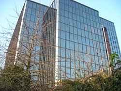
The NLA Tower
No.1 Croydon
No.1 Croydon is a skyscraper at 12-16 Addiscombe Road, Croydon, London, next to East Croydon station. It was designed by R. Seifert & Partners and completed in 1970. It has 24 storeys and is high. 'NLA' stood for 'Noble Lowndes Annuities'...
stands at the end of the road on an island in between a roundabout. It is currently the tallest skyscraper in the town and was occupied by AIG
AIG
AIG is American International Group, a major American insurance corporation.AIG may also refer to:* And-inverter graph, a concept in computer theory* Answers in Genesis, a creationist organization in the U.S.* Arta Industrial Group in Iran...
until 2009.
Cherry Orchard Road
Cherry Orchard Road is a planned regeneration project on land next to East Croydon Railway Station, which, dependent on planning permission, is scheduled for completion by 2015. It will improve transport links between the station and the road by adding a proposed station plaza with shops, restaurants and bars at ground level, which will link existing bus, taxi and tram services with East Croydon station.The site occupies 0.72 hectares and would be subject to a major mixed-use regeneration scheme. This would include a residential tall building, a hotel, a restaurant/bar, retail outlets and other residential buildings. Also included would be a large amount of public land and part of the new East-West Link planned by Network Rail which would include a new entrance to East Croydon Station.
It is the intention that a planning application will be submitted early in 2011.