
Cerro de la Silla
Encyclopedia
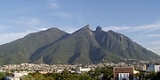
Cerro de la Silla named for its distinctive saddle
-shaped profile when viewed from the west, is a famous symbol of the landscape of the state of Nuevo León
, Mexico
. Even though the mountain itself is located in the adjacent city of Guadalupe
, it is widely associated to the city of Monterrey
, Mexico
.
It covers an area of 60.5 square kilometres (23 mi²). The mountain has four peaks: Pico Antena, Pico Norte, Pico Sur and Pico la Virgen; Pico Norte (North Peak) is the highest at 1820 m (5970 ft) while Pico la Virgen (Virgin's Peak) is the lowest at 1750 m (5740 ft).
Set aside as a Natural Monument by the government of Mexico in 1991, the hill is a popular recreational area and is often climbed by hikers
who take a 5.3 km (3.3 mi) trail to reach the top. The ascent is considered fairly difficult, requiring approximately 3 hours to complete. A panoramic view of the city of Monterrey can be seen from the top.
In the second half of the 20th century, an aerial tramway
was built to give a fastest access to the iconic mountain for the population. Sadly, the day of its inauguration was also the day of its closure, as a tragic accident took the lives of five people, including the engineer Jesús Fernández, its designer. Several plans have been announced to rebuild another tramway with no results.
Some other known mountains or elevations of the zone are: Cerro de las Mitras
, the Sierra Madre Oriental
—the "m" figure
visible from various parts of the city—, the Cerro del Topo Chico
, Cerro del Obispado
, Cerro de la Loma Larga
and La Huasteca.
Saddle
A saddle is a supportive structure for a rider or other load, fastened to an animal's back by a girth. The most common type is the equestrian saddle designed for a horse, but specialized saddles have been created for camels and other creatures...
-shaped profile when viewed from the west, is a famous symbol of the landscape of the state of Nuevo León
Nuevo León
Nuevo León It is located in Northeastern Mexico. It is bordered by the states of Tamaulipas to the north and east, San Luis Potosí to the south, and Coahuila to the west. To the north, Nuevo León has a 15 kilometer stretch of the U.S.-Mexico border adjacent to the U.S...
, Mexico
Mexico
The United Mexican States , commonly known as Mexico , is a federal constitutional republic in North America. It is bordered on the north by the United States; on the south and west by the Pacific Ocean; on the southeast by Guatemala, Belize, and the Caribbean Sea; and on the east by the Gulf of...
. Even though the mountain itself is located in the adjacent city of Guadalupe
Guadalupe, Nuevo León
Guadalupe is a city and surrounding municipality located in the state of Nuevo León, in northern Mexico. It is part of the Greater Monterrey Metropolitan area....
, it is widely associated to the city of Monterrey
Monterrey
Monterrey , is the capital city of the northeastern state of Nuevo León in the country of Mexico. The city is anchor to the third-largest metropolitan area in Mexico and is ranked as the ninth-largest city in the nation. Monterrey serves as a commercial center in the north of the country and is the...
, Mexico
Mexico
The United Mexican States , commonly known as Mexico , is a federal constitutional republic in North America. It is bordered on the north by the United States; on the south and west by the Pacific Ocean; on the southeast by Guatemala, Belize, and the Caribbean Sea; and on the east by the Gulf of...
.
It covers an area of 60.5 square kilometres (23 mi²). The mountain has four peaks: Pico Antena, Pico Norte, Pico Sur and Pico la Virgen; Pico Norte (North Peak) is the highest at 1820 m (5970 ft) while Pico la Virgen (Virgin's Peak) is the lowest at 1750 m (5740 ft).
Set aside as a Natural Monument by the government of Mexico in 1991, the hill is a popular recreational area and is often climbed by hikers
Hiking
Hiking is an outdoor activity which consists of walking in natural environments, often in mountainous or other scenic terrain. People often hike on hiking trails. It is such a popular activity that there are numerous hiking organizations worldwide. The health benefits of different types of hiking...
who take a 5.3 km (3.3 mi) trail to reach the top. The ascent is considered fairly difficult, requiring approximately 3 hours to complete. A panoramic view of the city of Monterrey can be seen from the top.
In the second half of the 20th century, an aerial tramway
Aerial tramway
An aerial tramway , cable car , ropeway or aerial tram is a type of aerial lift which uses one or two stationary ropes for support while a third moving rope provides propulsion...
was built to give a fastest access to the iconic mountain for the population. Sadly, the day of its inauguration was also the day of its closure, as a tragic accident took the lives of five people, including the engineer Jesús Fernández, its designer. Several plans have been announced to rebuild another tramway with no results.
Some other known mountains or elevations of the zone are: Cerro de las Mitras
Cerro de las Mitras
Cerro de las Mitras , named for its distinctive miter-shaped structures at the very top viewed from the northern side, is another symbol of the landscape of the state of Nuevo León, Mexico. Located in the cities of Monterrey, Santa Catarina and García....
, the Sierra Madre Oriental
Sierra Madre Oriental
The Sierra Madre Oriental is a mountain range in northeastern Mexico.-Setting:Spanning the Sierra Madre Oriental runs from Coahuila south through Nuevo León, southwest Tamaulipas, San Luis Potosí, Querétaro, and Hidalgo to northern Puebla, where it joins with the east-west running Eje Volcánico...
—the "m" figure
La m
Being part of the Sierra Madre Oriental, La m or the "eme" is a figure located on top of the mountain chain, in the state of Nuevo León, México....
visible from various parts of the city—, the Cerro del Topo Chico
Cerro del Topo Chico
Cerro del Topo Chico is an inactive volcano located in the western portion of the city of San Nicolás de los Garza and within the northern limits of the Monterrey metropolitan area .The gray areas depicted on the photos are limestone quarries from which raw material is extracted to manufacture...
, Cerro del Obispado
Cerro del Obispado
The Cerro del Obispado is a famous landmark in the city of Monterrey, Mexico, named after the building constructed in the middle of the hill by the end of the 18th century....
, Cerro de la Loma Larga
Cerro de la Loma Larga
Cerro de la Loma Larga , or Loma Larga located in the Monterrey, Nuevo León metropolitan area is a lower extension of the Sierra Madre Oriental, in particular an eastern extension of Cerro de las Mitras.The hill has long been considered the natural division of the now adjacent cities of Monterrey...
and La Huasteca.
External links
- Cerro de la Silla information (Spanish)
- Mexico Desconocido (Spanish)