
Cerro de las Mitras
Encyclopedia
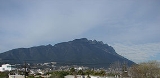
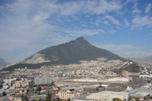
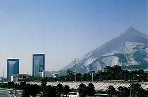
Cerro de las Mitras named for its distinctive miter-shaped structures at the very top viewed from the northern side, is another symbol of the landscape of the state of Nuevo León
, Mexico
. Located in the cities of Monterrey
, Santa Catarina
and García
.
Being part of the Cumbres National park by the Mexican government, the mountain is often climbed by hikers
. The ascent is considered fairly difficult to complete. A panoramic view of the city of Monterrey can be seen from the top.
The south/southeast face of the mountain is source of raw material for the local concrete manufacturers (the craters are noticeable in the photos for their lighter gray colors).
Some other known mountains or elevations of the zone are: the Cerro de la Silla
, the Sierra Madre Oriental
-with its "m" figure
-, the Cerro del Topo Chico
, Cerro del Obispado
, Cerro de la Loma Larga
and La Huasteca.

Nuevo León
Nuevo León It is located in Northeastern Mexico. It is bordered by the states of Tamaulipas to the north and east, San Luis Potosí to the south, and Coahuila to the west. To the north, Nuevo León has a 15 kilometer stretch of the U.S.-Mexico border adjacent to the U.S...
, Mexico
Mexico
The United Mexican States , commonly known as Mexico , is a federal constitutional republic in North America. It is bordered on the north by the United States; on the south and west by the Pacific Ocean; on the southeast by Guatemala, Belize, and the Caribbean Sea; and on the east by the Gulf of...
. Located in the cities of Monterrey
Monterrey
Monterrey , is the capital city of the northeastern state of Nuevo León in the country of Mexico. The city is anchor to the third-largest metropolitan area in Mexico and is ranked as the ninth-largest city in the nation. Monterrey serves as a commercial center in the north of the country and is the...
, Santa Catarina
Santa Catarina, Nuevo León
Santa Catarina is a city and municipality in the state of Nuevo León, Mexico that is part of the Monterrey Metropolitan area.-History:The name of this city comes from the Catholic Saint Catherine of Alexandria....
and García
García, Nuevo León
García is a municipality located to the northwest of the Monterrey metropolitan area in the state of Nuevo León, Mexico. García had, according to the 2005 census, a population of 51,658 persons...
.
Being part of the Cumbres National park by the Mexican government, the mountain is often climbed by hikers
Hiking
Hiking is an outdoor activity which consists of walking in natural environments, often in mountainous or other scenic terrain. People often hike on hiking trails. It is such a popular activity that there are numerous hiking organizations worldwide. The health benefits of different types of hiking...
. The ascent is considered fairly difficult to complete. A panoramic view of the city of Monterrey can be seen from the top.
The south/southeast face of the mountain is source of raw material for the local concrete manufacturers (the craters are noticeable in the photos for their lighter gray colors).
Some other known mountains or elevations of the zone are: the Cerro de la Silla
Cerro de la Silla
Cerro de la Silla , named for its distinctive saddle-shaped profile when viewed from the west, is a famous symbol of the landscape of the state of Nuevo León, Mexico. Even though the mountain itself is located in the adjacent city of Guadalupe, it is widely associated to the city of Monterrey,...
, the Sierra Madre Oriental
Sierra Madre Oriental
The Sierra Madre Oriental is a mountain range in northeastern Mexico.-Setting:Spanning the Sierra Madre Oriental runs from Coahuila south through Nuevo León, southwest Tamaulipas, San Luis Potosí, Querétaro, and Hidalgo to northern Puebla, where it joins with the east-west running Eje Volcánico...
-with its "m" figure
La m
Being part of the Sierra Madre Oriental, La m or the "eme" is a figure located on top of the mountain chain, in the state of Nuevo León, México....
-, the Cerro del Topo Chico
Cerro del Topo Chico
Cerro del Topo Chico is an inactive volcano located in the western portion of the city of San Nicolás de los Garza and within the northern limits of the Monterrey metropolitan area .The gray areas depicted on the photos are limestone quarries from which raw material is extracted to manufacture...
, Cerro del Obispado
Cerro del Obispado
The Cerro del Obispado is a famous landmark in the city of Monterrey, Mexico, named after the building constructed in the middle of the hill by the end of the 18th century....
, Cerro de la Loma Larga
Cerro de la Loma Larga
Cerro de la Loma Larga , or Loma Larga located in the Monterrey, Nuevo León metropolitan area is a lower extension of the Sierra Madre Oriental, in particular an eastern extension of Cerro de las Mitras.The hill has long been considered the natural division of the now adjacent cities of Monterrey...
and La Huasteca.