
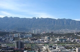
Cerro de la Loma Larga
Encyclopedia
Cerro de la Loma Larga or Loma Larga (short version) located in the Monterrey
, Nuevo León
metropolitan area is a lower extension of the Sierra Madre Oriental
, in particular an eastern extension of Cerro de las Mitras
.
The hill has long been considered the natural division of the now adjacent cities of Monterrey
and San Pedro Garza García
.
For its short range of about 10 kilometers it is flanked on its northern side by the Santa Catarina River, and on its southern side, the Sierra Madre Oriental
in almost full height.
Its nearby geological companions make of it a rather unremarkable elevation, and residential areas, shops, high buildings and freeways have been constructed all over it.
The Diana Cazadora statue marking the joint of Monterrey and San Perdo Garza García was placed along a busy avenue (Gonzalitos) crossing over the hill. The government's local TVstation, Canal 28 is located on it. And the Basílica de Guadalupe
in Monterrey is also located on the hill, among other churches.
In the early 2000s the state's government project of a tunnel giving way between Monterrey and San Pedro Garza García was done, having the Loma Larga Tunnel
finally finished.
Some other known mountains or elevations of the zone are: Cerro de la Silla
, Cerro de las Mitras
, the Sierra Madre Oriental
-the "m" figure
visible from various parts of the city-, the Cerro del Topo Chico
, Cerro del Obispado
and La Huasteca.
Monterrey
Monterrey , is the capital city of the northeastern state of Nuevo León in the country of Mexico. The city is anchor to the third-largest metropolitan area in Mexico and is ranked as the ninth-largest city in the nation. Monterrey serves as a commercial center in the north of the country and is the...
, Nuevo León
Nuevo León
Nuevo León It is located in Northeastern Mexico. It is bordered by the states of Tamaulipas to the north and east, San Luis Potosí to the south, and Coahuila to the west. To the north, Nuevo León has a 15 kilometer stretch of the U.S.-Mexico border adjacent to the U.S...
metropolitan area is a lower extension of the Sierra Madre Oriental
Sierra Madre Oriental
The Sierra Madre Oriental is a mountain range in northeastern Mexico.-Setting:Spanning the Sierra Madre Oriental runs from Coahuila south through Nuevo León, southwest Tamaulipas, San Luis Potosí, Querétaro, and Hidalgo to northern Puebla, where it joins with the east-west running Eje Volcánico...
, in particular an eastern extension of Cerro de las Mitras
Cerro de las Mitras
Cerro de las Mitras , named for its distinctive miter-shaped structures at the very top viewed from the northern side, is another symbol of the landscape of the state of Nuevo León, Mexico. Located in the cities of Monterrey, Santa Catarina and García....
.
The hill has long been considered the natural division of the now adjacent cities of Monterrey
Monterrey
Monterrey , is the capital city of the northeastern state of Nuevo León in the country of Mexico. The city is anchor to the third-largest metropolitan area in Mexico and is ranked as the ninth-largest city in the nation. Monterrey serves as a commercial center in the north of the country and is the...
and San Pedro Garza García
San Pedro Garza García
San Pedro Garza García is a city-municipality of the Mexican state of Nuevo León and is part of Monterrey's Metropolitan Area, based on the suburban North American model...
.
For its short range of about 10 kilometers it is flanked on its northern side by the Santa Catarina River, and on its southern side, the Sierra Madre Oriental
Sierra Madre Oriental
The Sierra Madre Oriental is a mountain range in northeastern Mexico.-Setting:Spanning the Sierra Madre Oriental runs from Coahuila south through Nuevo León, southwest Tamaulipas, San Luis Potosí, Querétaro, and Hidalgo to northern Puebla, where it joins with the east-west running Eje Volcánico...
in almost full height.
Its nearby geological companions make of it a rather unremarkable elevation, and residential areas, shops, high buildings and freeways have been constructed all over it.
The Diana Cazadora statue marking the joint of Monterrey and San Perdo Garza García was placed along a busy avenue (Gonzalitos) crossing over the hill. The government's local TVstation, Canal 28 is located on it. And the Basílica de Guadalupe
Basilica of Guadalupe, Monterrey
The Basilica of Guadalupe or Santuario de Nuestra Señora de Guadalupe, is a Roman Catholic church located in the metropolitan area of Monterrey, Nuevo León, Mexico. Lying in the neighborhood of Colonia Independencia, just outside of the city's downtown area, the temple is one of the larger Church...
in Monterrey is also located on the hill, among other churches.
In the early 2000s the state's government project of a tunnel giving way between Monterrey and San Pedro Garza García was done, having the Loma Larga Tunnel
Loma Larga Tunnel
Loma Larga Tunnel, or, as it is known by the locals, Túnel de la Loma Larga, is a man made tunnel constructed in the bowels of the Cerro de la Loma Larga, in the limits of the cities of Monterrey and San Pedro Garza García in Nuevo León, México....
finally finished.
Some other known mountains or elevations of the zone are: Cerro de la Silla
Cerro de la Silla
Cerro de la Silla , named for its distinctive saddle-shaped profile when viewed from the west, is a famous symbol of the landscape of the state of Nuevo León, Mexico. Even though the mountain itself is located in the adjacent city of Guadalupe, it is widely associated to the city of Monterrey,...
, Cerro de las Mitras
Cerro de las Mitras
Cerro de las Mitras , named for its distinctive miter-shaped structures at the very top viewed from the northern side, is another symbol of the landscape of the state of Nuevo León, Mexico. Located in the cities of Monterrey, Santa Catarina and García....
, the Sierra Madre Oriental
Sierra Madre Oriental
The Sierra Madre Oriental is a mountain range in northeastern Mexico.-Setting:Spanning the Sierra Madre Oriental runs from Coahuila south through Nuevo León, southwest Tamaulipas, San Luis Potosí, Querétaro, and Hidalgo to northern Puebla, where it joins with the east-west running Eje Volcánico...
-the "m" figure
La m
Being part of the Sierra Madre Oriental, La m or the "eme" is a figure located on top of the mountain chain, in the state of Nuevo León, México....
visible from various parts of the city-, the Cerro del Topo Chico
Cerro del Topo Chico
Cerro del Topo Chico is an inactive volcano located in the western portion of the city of San Nicolás de los Garza and within the northern limits of the Monterrey metropolitan area .The gray areas depicted on the photos are limestone quarries from which raw material is extracted to manufacture...
, Cerro del Obispado
Cerro del Obispado
The Cerro del Obispado is a famous landmark in the city of Monterrey, Mexico, named after the building constructed in the middle of the hill by the end of the 18th century....
and La Huasteca.