
Carrier Mills, Illinois
Encyclopedia
Carrier Mills, formerly Carriers Mills and Morrilsville, also known as Catskin, is a village in Saline County
, Illinois
, United States
. The population was 1,886 at the 2000 census. Carrier Mills was named after George Washington Carrier and his saw and grist mill, and was one of the early Cairo and Vincennes Railroad
boomtown
s. Carrier Mills has lost 1,290 People since the 1920 census high of 2,943. The village has an unusually large African American
population at 13%, compared to neighboring communities in the region, due to migration from the nearby community of Lakeview
.
The city has been nicknamed "Catskin" due to both an abundance of stray cats
in town, and a late-19th century story of the first local merchandise and liquor store owner, Wes Cole, who was tricked by local kids into thinking a skinned cat hide was a mink
stole in trade for a jug of whiskey. To this day Carrier Mills is host to the annual Catskin Days town fair and parade. The township's school mascot is the Wildcat.
Carrier Mills is included in the Illinois-Indiana-Kentucky Tri-State Area
and is the third largest community in the Harrisburg Micropolitan Statistical Area
outside of Eldorado
and Harrisburg
.
According to the United States Census Bureau
, the village has a total area of 1.2 square miles (3.1 km²), of which, 1.2 square miles (3.1 km²) of it is land and 0.81% is water.
Carrier Mills sits upon a heavily undermined
hillside that overlooks a shallow flatland to the south, where its sister community of Lakeview
was built in a region of swampy land drained by the South Fork of the Saline River
. In the distance, two ridges of the Shawnee Hills
can be seen from town in a distinct blue haze.
The village is split into two distinct sections with Washington Street being the only main east-west oriented avenue connecting them. In between the two sections is the elevated New York Central Railroad bed, now the Tunnel Hill State Trail
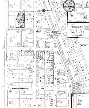
, on a large swath of grass, and the now defunct streetcar bypass on Carline Street, splitting the village in a southwest to northeast angle. Downtown is located in the southwest corner, the largest section of the village to the northwest, and East End to the southeast, US Route 45 borders the southern edge, giving Carrier Mills it's distinctive 'L' shape.
As of the census
of 2000, there were 1,886 people, 798 households and 501 families residing in the village. The population density
was 1,522.9 per square mile (587.2/km²). There were 942 housing units at an average density of 760.6/sq mi (293.3/km²). The racial makeup of the village was 84.84% White, 12.94% African American, 0.32% Native American, 0.16% Asian, 0.48% from other races
, and 1.27% from two or more races. Hispanic or Latino of any race were 0.90% of the population.
There were 798 households out of which 25.4% had children under the age of 18, 47.6% were married couples
living together, 11.2% had a female householder with no husband present, and 37.2% were non-families. 34.0% of all households were made up of individuals and 18.9% had someone living alone who was 65 years of age or older. The average household size was 2.24 and the average family size was 2.84.
In the village the population was spread out with 21.2% under the age of 18, 8.9% aged 18 to 24, 23.2% from 25 to 44, 22.6% from 45 to 64, and 24.0% 65 years of age or older. The median age was 42 years. For every 100 females there were 84.5 males. For every 100 females aged 18 and over, there were 81.2 males.
The median household income
was $25,493, and the family median income was $35,037. Males had a median income of $31,458 compared to $16,756 for females. The per capita income
for the village was $14,314. About 13.2% of families and 17.7% of the population were living below the poverty line, including 23.4% of those under age 18 and 16.7% of those aged 65 or over.
, where most of the town's citizens do their business and shopping. It was platted in November 1872 for William Housely as Morrillsville, named after H. L. Morrill the Cairo and Vincennes Railroad
superintendent who sealed a real-estate deal with Mill owner G. W. Carrier. It was commonly known and eventually renamed Carrier's Mills after inventor G. Washington Carrier ("Uncle Wash") who helped found the town when he built an elaborate steam powered saw and a grist mill just to the south of town on the Saline River
watershed, near the old Tuller Mansion farming and property site. Carrier's Mills was the farthest north Cypress Trees
grew at the time, which made lumber milling in the town quite profitable. Carrier was the first of many to set up wood working factories within the city limits. The mills were first used for the making of lumber
to construct bridges and ties for the Cairo and Vincennes Railroad, then later the business and homes in the town soon followed.
Carrier and Morrill closed a real-estate deal to build a train depot there. The town was platted adjacent and north of the newly completed Cairo and Vincennes Railroad
. In 1873, the first postmaster was appointed to Carrier's Mills (the name the railroad had assigned to the new stop). The town's name changed again to Carrier Mills when several more wood working factories were built. The village was incorporated on September 18, 1894. After an influx of settlers from the south, due to the Civil War
, the tiny village amidst timber and farms grew quickly. Today, in legal documents its name remains Morrillsville. Carrier Mills did not have a single brick building and the sidewalks were of boards. The business district was mainly from the First National Bank west to the Texaco Gas Station, and all of frame construction. A disastrous fire in February 1908 burned everything on the north side of the street. In the next month, March 1908, fire burned everything on the south side of the street, from Main to Mill, except the Old Woolcott Mill Exchange. The businessmen began immediately to rebuild, all of brick construction.
Tuller Mansion, or "Tuller Place" was a victorian, 1910, two-story manor, constructed of red brick from the Terre Haute Block Company built on the outskirts of town. There was a grand entry staircase with marble floors, clawfoot tubs, built-in china cabinets, and fine mahogany wood throughout. A large elegant patio served to entertain guests in hosting social dances, and even a carport existed for the two vehicles that Mr. Tuller owned. The mansion was built on the Carrier-Vennum estate, nicknamed "Inland Farm", by Arthur V. Tuller, inlaws of George Washington Carrier, The town's founder. The house burned in the 1980s.
After the lumber boom died out, Coal mining
had a great influence on Carrier Mills. Some dozen coal mines privately and publicly owned were located around the town. Carrier Mills, from 1913 to 1933, was the southern terminus of the Southern Illinois Railway & Power Company's Interurban Line. The trolley would take residents from downtown, and along Carline Street toward Harrsburg. During the town's heyday, some 3,000 people bustled around the busy streets. After the coal mines closed the population dwindled to nearly 1,500 according to the 2010 census. The entire county has suffered dearly from the closing of the coal mines, making Carrier Mills a near ghost town
. In 2009 Carrier Mills ended a 70 year long prohibition.
 The first school in Carrier Mills was a large, two-story wooden structure with a bell tower. It was built in the early 1820s and located near the old Sahara Coal Company preparation plant (now abandoned), just northwest of the village. The little structure was made of logs and had a clay chimney. School year began in August and ended in October because of the extreme cold. A typical school in 1850 was a subscription school - a fee of $2.50 was charged for a two-month period. From the Civil War
period until 1875, the only formal school was located near Salem.
In 1887, the first school building in Carrier Mills Village was purchased for the purpose of being a prescription school at the corner of Walnut and Main St. The first major public school in the town was opened in 1903 on Furlong St. The first recognized two year high school course was started in 1915. In 1917, the high school became a registered three-year high school until 1926 when it became a community high school fully accredited by the state of Illinois
.
Around 1940, the Carrier Mills Public School building burned down after a disastrous fire starting during a Boy Scout
meeting in the basement. A much larger school was built a year later as a grade school around the frame of the first burnt school.
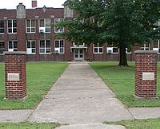
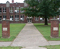
On February 4, 1938, the present building was completed and occupied, with the gymnasium and auditorium added in 1940. The current enlarged gym was built in 1950-1. At the beginning of 1963, the small town of Stonefort joined the Carrier Mills school district creating the Carrier Mills-Stonefort Unit 2 School District.
. Citizens of Carrier Mills said it was better to see empty lots than rotten buildings. Most citizens found it sad that it had to come to such a conclusion.
 The business district has been in a slow decline for at least 25 years. No single big event can be tied to the decline of downtown Carrier Mills. Will Scarlet Mine closed in 1987. Sahara's mines closed in 1993, putting hundreds out of work. Each of those closures reverberated through the local economy. Sahara had a reputation for buying locally—when their purchasing ceased it was a big blow to local businesses. But the Carrier Mills downtown area slowly declining even before the big mine closures.
In its heyday, Carrier Mills was home to several hotels, two theaters (The Knox, and the Grand Theater, opened in 1936 and closed in 1970), two banks (Dodds Bank and the First National), several stores and markets. Nearly all have been slowly torn or burned down over the past 20 years.
There were small stores on Friend, Main, East End and Washington Streets—in some instances a small store could be found every few blocks. The small grocery stores gradually shut down as car ownership increased and people were therefore more mobile—something that contributed generally to the decline of small towns like Carrier Mills.
A new building ordinance was set in July 2006 for future construction plans in the vacant downtown area. According to Mayor Louis Shaw, "What we're concerned about is when you walk into town, it doesn't look like a farm."
In April 2007, Carrier Mills Village Board approved entering an agreement with Bob Vancil and Associates to set up a tax increment finance district in an effort to draw new homeowners and businesses. The TIF district is a chance for the village to increase the quality of life with new houses and incentives for improving houses that are in disrepair. Village Board members described establishing the TIF district as a roll of the dice. Vancil will set up the TIF for $15,000 with $5,000 paid up front. If the Scarlet Lake annexation does not happen and the board learns the TIF will not be of benefit to the village, they will not owe the additional $10,000. Vancil said the village will be responsible for paying $3,000 in legal requirements for the TIF, which include giving notice to all businesses and legal advertising in newspapers.
The Scarlet Lake subdivision is a series of 52 lots within the old Will Scarlet strip pit mining area. It will be added to the Village limits as part of the TIF/Annexation project.
In June 2011 the old field and dime store collapsed in Carrier Mills due to disrepair. One of only four downtown structures left in the village.
history and influence. Free blacks founded the small early pioneer settlement of Lakeview, a mile south of Carrier Mills, shortly after the War of 1812. The History of Saline County (published by Saline County
Genealogical Society in 1997) states that "Lakeview, a colored community south of town (Carrier Mills), is an older settlement than Carrier Mills. It is the oldest black settlement in Illinois. It was first named Pond Settlement because of the swamp
land that surrounded it. According to local tradition free blacks living in the Pond Settlement helped runaway slaves and indentured servants escape from the saline works and the Old Slave House near Equality, Illinois.
Lakeview had its own school and grocery store along with many homes. In 1850, a Union Church was established near Carrier Mills in Saline Co., Illinois. Most members were either Baptist or Methodist. An African Methodist Episcopal Church was organized at the home of Irvin Allen, who built a one-room log church building on his property. After the church burned, the congregation rebuilt and moved the church to Carrier Mills, where it sits today. This congregation is now Baber Chapel AME Church. The Lakeview cemetery has become a state historical landmark. The area of Lakeview is still a nearly 100% black area. After the closure of the Lakeview school in the 1950s, many people moved to the east side of Carrier Mills. There was much tension felt between the white and black populations in the town.
was a meandering stream with large areas of swamps and shallow cypress lakes nearby. These areas were rich in plants and animals that prehistoric inhabitants sought for food. Therefore, the locality became a natural focal point for human settlement. In 1978 and 1979, archeologists intensively investigated this area. Excellent preservation conditions permitted the recovery of many tools and animal and plant remains that have provided significant new insights into the prehistory of southern Illinois.
Sporadic use of the area by small groups of hunters and gatherers can be dated to 8000 BC, and the area was used more or less continuously until 1400 AD. Settlement activity increased dramatically during the late Middle Archaic Period, 4500 to 3000 BC, when the area was inhabited by larger groups with a more settled lifestyle. These occupants left archaeological evidence containing many artifacts and burials. The area also saw heavy use during the Middle and Late Woodland periods, 200 BC to 900 AD. The peoples of those times increasingly focused on the collection and storage of plant foods and began to domesticate some native plants. The final prehistoric inhabitants were Mississippian Period Indians (AD 900 to 1400) who lived in scattered farmsteads and cultivated corn and squash.
Saline County, Illinois
Saline County is a county located in the U.S. state of Illinois. According to the 2010 census, it has a population of 24,913, which is a decrease of 6.8% from 26,733 in 2000. Its county seat is Harrisburg. Saline County is home to the smallest post office and the largest KFC in the United States....
, Illinois
Illinois
Illinois is the fifth-most populous state of the United States of America, and is often noted for being a microcosm of the entire country. With Chicago in the northeast, small industrial cities and great agricultural productivity in central and northern Illinois, and natural resources like coal,...
, United States
United States
The United States of America is a federal constitutional republic comprising fifty states and a federal district...
. The population was 1,886 at the 2000 census. Carrier Mills was named after George Washington Carrier and his saw and grist mill, and was one of the early Cairo and Vincennes Railroad
Cairo and Vincennes Railroad
The Cairo and Vincennes Railroad was a 19th-century American railroad that connected Cairo, Illinois, with Vincennes, Indiana. It was chartered by the state of Illinois in 1867 through the efforts of former American Civil War General Green B. Raum, who subsequently oversaw the planning and...
boomtown
Boomtown
A boomtown is a community that experiences sudden and rapid population and economic growth. The growth is normally attributed to the nearby discovery of a precious resource such as gold, silver, or oil, although the term can also be applied to communities growing very rapidly for different reasons,...
s. Carrier Mills has lost 1,290 People since the 1920 census high of 2,943. The village has an unusually large African American
African American
African Americans are citizens or residents of the United States who have at least partial ancestry from any of the native populations of Sub-Saharan Africa and are the direct descendants of enslaved Africans within the boundaries of the present United States...
population at 13%, compared to neighboring communities in the region, due to migration from the nearby community of Lakeview
Lakeview, Illinois
Lakeview is an unincorporated dominantly African American community in the Carrier Mills township, Saline County, Illinois, United States. Lakeview was originally called "The Pond Settlement" It was named after the Cypress swampland and wetlands that surrounds the area of Carrier Mills...
.
The city has been nicknamed "Catskin" due to both an abundance of stray cats
Cat
The cat , also known as the domestic cat or housecat to distinguish it from other felids and felines, is a small, usually furry, domesticated, carnivorous mammal that is valued by humans for its companionship and for its ability to hunt vermin and household pests...
in town, and a late-19th century story of the first local merchandise and liquor store owner, Wes Cole, who was tricked by local kids into thinking a skinned cat hide was a mink
Mink
There are two living species referred to as "mink": the European Mink and the American Mink. The extinct Sea Mink is related to the American Mink, but was much larger. All three species are dark-colored, semi-aquatic, carnivorous mammals of the family Mustelidae, which also includes the weasels and...
stole in trade for a jug of whiskey. To this day Carrier Mills is host to the annual Catskin Days town fair and parade. The township's school mascot is the Wildcat.
Carrier Mills is included in the Illinois-Indiana-Kentucky Tri-State Area
Illinois-Indiana-Kentucky Tri-State Area
The Illinois–Indiana–Kentucky Tri-State Area is a tri-state area where the states of Illinois, Indiana, and Kentucky intersect. The area is defined mainly by the television viewing area and consists of ten Illinois counties, eleven Indiana counties, and nine Kentucky counties...
and is the third largest community in the Harrisburg Micropolitan Statistical Area
Harrisburg, Illinois Micropolitan Statistical Area
The Harrisburg Micropolitan Statistical Area, as defined by the United States Census Bureau, is an area consisting of one county in southern Illinois, anchored by the city of Harrisburg.As of the 2000 census, the μSA had a population of 26,733....
outside of Eldorado
Eldorado, Illinois
Eldorado is a city in Saline County, Illinois, United States. The population was 4,122 at the 2010 census, with a 1925 peak of 8,000. Although the city's name is spelled as if it were Spanish, the name was originally "Elder-Reado" -- a combination of the last names of the town's two founders,...
and Harrisburg
Harrisburg, Illinois
Harrisburg is a city and township in Saline County, Illinois, United States. It is located about southwest of Evansville, Indiana, southeast of St. Louis, Missouri. The 2010 population was 9,017, with a township population of 10,790. It is the county seat of Saline County...
.
Geography
Carrier Mills is located at 37°41′13"N 88°37′45"W (37.686923, -88.629149).According to the United States Census Bureau
United States Census Bureau
The United States Census Bureau is the government agency that is responsible for the United States Census. It also gathers other national demographic and economic data...
, the village has a total area of 1.2 square miles (3.1 km²), of which, 1.2 square miles (3.1 km²) of it is land and 0.81% is water.
Carrier Mills sits upon a heavily undermined
Room and pillar
Room and pillar is a mining system in which the mined material is extracted across a horizontal plane while leaving "pillars" of untouched material to support the roof overburden leaving open areas or "rooms" underground...
hillside that overlooks a shallow flatland to the south, where its sister community of Lakeview
Lakeview, Illinois
Lakeview is an unincorporated dominantly African American community in the Carrier Mills township, Saline County, Illinois, United States. Lakeview was originally called "The Pond Settlement" It was named after the Cypress swampland and wetlands that surrounds the area of Carrier Mills...
was built in a region of swampy land drained by the South Fork of the Saline River
Saline River (Illinois)
The Saline River is a tributary of the Ohio River, approximately long, in the Southern Illinois region of the U.S. state of Illinois. The river drains a large section of southeast Illinois, with a drainage basin of . The major tributaries include the South Fork, Middle Fork and North Fork, all...
. In the distance, two ridges of the Shawnee Hills
Shawnee Hills
The Shawnee Hills is a region of Southern Illinois that rests mainly in an east-west arc roughly following the outline of the southern end of the Illinois Basin. Whereas Mississippian and Pennsylvania Age rock layers are deep beneath the surface in central Illinois, these strata pierce the surface...
can be seen from town in a distinct blue haze.
The village is split into two distinct sections with Washington Street being the only main east-west oriented avenue connecting them. In between the two sections is the elevated New York Central Railroad bed, now the Tunnel Hill State Trail
Tunnel Hill State Trail
The Tunnel Hill State Trail is a bicycle trail running from Harrisburg to Karnak, Illinois. The trail runs along the former bed of a part of the Cairo and Vincennes Railroad, a transportation unit led during its early years by Civil War General Ambrose Burnside...
, on a large swath of grass, and the now defunct streetcar bypass on Carline Street, splitting the village in a southwest to northeast angle. Downtown is located in the southwest corner, the largest section of the village to the northwest, and East End to the southeast, US Route 45 borders the southern edge, giving Carrier Mills it's distinctive 'L' shape.
Demographics
As of the census
Census
A census is the procedure of systematically acquiring and recording information about the members of a given population. It is a regularly occurring and official count of a particular population. The term is used mostly in connection with national population and housing censuses; other common...
of 2000, there were 1,886 people, 798 households and 501 families residing in the village. The population density
Population density
Population density is a measurement of population per unit area or unit volume. It is frequently applied to living organisms, and particularly to humans...
was 1,522.9 per square mile (587.2/km²). There were 942 housing units at an average density of 760.6/sq mi (293.3/km²). The racial makeup of the village was 84.84% White, 12.94% African American, 0.32% Native American, 0.16% Asian, 0.48% from other races
Race (United States Census)
Race and ethnicity in the United States Census, as defined by the Federal Office of Management and Budget and the United States Census Bureau, are self-identification data items in which residents choose the race or races with which they most closely identify, and indicate whether or not they are...
, and 1.27% from two or more races. Hispanic or Latino of any race were 0.90% of the population.
There were 798 households out of which 25.4% had children under the age of 18, 47.6% were married couples
Marriage
Marriage is a social union or legal contract between people that creates kinship. It is an institution in which interpersonal relationships, usually intimate and sexual, are acknowledged in a variety of ways, depending on the culture or subculture in which it is found...
living together, 11.2% had a female householder with no husband present, and 37.2% were non-families. 34.0% of all households were made up of individuals and 18.9% had someone living alone who was 65 years of age or older. The average household size was 2.24 and the average family size was 2.84.
In the village the population was spread out with 21.2% under the age of 18, 8.9% aged 18 to 24, 23.2% from 25 to 44, 22.6% from 45 to 64, and 24.0% 65 years of age or older. The median age was 42 years. For every 100 females there were 84.5 males. For every 100 females aged 18 and over, there were 81.2 males.
The median household income
Median household income
The median household income is commonly used to generate data about geographic areas and divides households into two equal segments with the first half of households earning less than the median household income and the other half earning more...
was $25,493, and the family median income was $35,037. Males had a median income of $31,458 compared to $16,756 for females. The per capita income
Per capita income
Per capita income or income per person is a measure of mean income within an economic aggregate, such as a country or city. It is calculated by taking a measure of all sources of income in the aggregate and dividing it by the total population...
for the village was $14,314. About 13.2% of families and 17.7% of the population were living below the poverty line, including 23.4% of those under age 18 and 16.7% of those aged 65 or over.
History
Carrier Mills is located seven miles (11 km) southwest of Harrisburg, IllinoisHarrisburg, Illinois
Harrisburg is a city and township in Saline County, Illinois, United States. It is located about southwest of Evansville, Indiana, southeast of St. Louis, Missouri. The 2010 population was 9,017, with a township population of 10,790. It is the county seat of Saline County...
, where most of the town's citizens do their business and shopping. It was platted in November 1872 for William Housely as Morrillsville, named after H. L. Morrill the Cairo and Vincennes Railroad
Cairo and Vincennes Railroad
The Cairo and Vincennes Railroad was a 19th-century American railroad that connected Cairo, Illinois, with Vincennes, Indiana. It was chartered by the state of Illinois in 1867 through the efforts of former American Civil War General Green B. Raum, who subsequently oversaw the planning and...
superintendent who sealed a real-estate deal with Mill owner G. W. Carrier. It was commonly known and eventually renamed Carrier's Mills after inventor G. Washington Carrier ("Uncle Wash") who helped found the town when he built an elaborate steam powered saw and a grist mill just to the south of town on the Saline River
Saline River (Illinois)
The Saline River is a tributary of the Ohio River, approximately long, in the Southern Illinois region of the U.S. state of Illinois. The river drains a large section of southeast Illinois, with a drainage basin of . The major tributaries include the South Fork, Middle Fork and North Fork, all...
watershed, near the old Tuller Mansion farming and property site. Carrier's Mills was the farthest north Cypress Trees
Cypress
Cypress is the name applied to many plants in the cypress family Cupressaceae, which is a conifer of northern temperate regions. Most cypress species are trees, while a few are shrubs...
grew at the time, which made lumber milling in the town quite profitable. Carrier was the first of many to set up wood working factories within the city limits. The mills were first used for the making of lumber
Lumber
Lumber or timber is wood in any of its stages from felling through readiness for use as structural material for construction, or wood pulp for paper production....
to construct bridges and ties for the Cairo and Vincennes Railroad, then later the business and homes in the town soon followed.
Carrier and Morrill closed a real-estate deal to build a train depot there. The town was platted adjacent and north of the newly completed Cairo and Vincennes Railroad
Cairo and Vincennes Railroad
The Cairo and Vincennes Railroad was a 19th-century American railroad that connected Cairo, Illinois, with Vincennes, Indiana. It was chartered by the state of Illinois in 1867 through the efforts of former American Civil War General Green B. Raum, who subsequently oversaw the planning and...
. In 1873, the first postmaster was appointed to Carrier's Mills (the name the railroad had assigned to the new stop). The town's name changed again to Carrier Mills when several more wood working factories were built. The village was incorporated on September 18, 1894. After an influx of settlers from the south, due to the Civil War
American Civil War
The American Civil War was a civil war fought in the United States of America. In response to the election of Abraham Lincoln as President of the United States, 11 southern slave states declared their secession from the United States and formed the Confederate States of America ; the other 25...
, the tiny village amidst timber and farms grew quickly. Today, in legal documents its name remains Morrillsville. Carrier Mills did not have a single brick building and the sidewalks were of boards. The business district was mainly from the First National Bank west to the Texaco Gas Station, and all of frame construction. A disastrous fire in February 1908 burned everything on the north side of the street. In the next month, March 1908, fire burned everything on the south side of the street, from Main to Mill, except the Old Woolcott Mill Exchange. The businessmen began immediately to rebuild, all of brick construction.
Tuller Mansion, or "Tuller Place" was a victorian, 1910, two-story manor, constructed of red brick from the Terre Haute Block Company built on the outskirts of town. There was a grand entry staircase with marble floors, clawfoot tubs, built-in china cabinets, and fine mahogany wood throughout. A large elegant patio served to entertain guests in hosting social dances, and even a carport existed for the two vehicles that Mr. Tuller owned. The mansion was built on the Carrier-Vennum estate, nicknamed "Inland Farm", by Arthur V. Tuller, inlaws of George Washington Carrier, The town's founder. The house burned in the 1980s.
After the lumber boom died out, Coal mining
Coal mining
The goal of coal mining is to obtain coal from the ground. Coal is valued for its energy content, and since the 1880s has been widely used to generate electricity. Steel and cement industries use coal as a fuel for extraction of iron from iron ore and for cement production. In the United States,...
had a great influence on Carrier Mills. Some dozen coal mines privately and publicly owned were located around the town. Carrier Mills, from 1913 to 1933, was the southern terminus of the Southern Illinois Railway & Power Company's Interurban Line. The trolley would take residents from downtown, and along Carline Street toward Harrsburg. During the town's heyday, some 3,000 people bustled around the busy streets. After the coal mines closed the population dwindled to nearly 1,500 according to the 2010 census. The entire county has suffered dearly from the closing of the coal mines, making Carrier Mills a near ghost town
Ghost town
A ghost town is an abandoned town or city. A town often becomes a ghost town because the economic activity that supported it has failed, or due to natural or human-caused disasters such as floods, government actions, uncontrolled lawlessness, war, or nuclear disasters...
. In 2009 Carrier Mills ended a 70 year long prohibition.
Local School History
American Civil War
The American Civil War was a civil war fought in the United States of America. In response to the election of Abraham Lincoln as President of the United States, 11 southern slave states declared their secession from the United States and formed the Confederate States of America ; the other 25...
period until 1875, the only formal school was located near Salem.
In 1887, the first school building in Carrier Mills Village was purchased for the purpose of being a prescription school at the corner of Walnut and Main St. The first major public school in the town was opened in 1903 on Furlong St. The first recognized two year high school course was started in 1915. In 1917, the high school became a registered three-year high school until 1926 when it became a community high school fully accredited by the state of Illinois
Illinois
Illinois is the fifth-most populous state of the United States of America, and is often noted for being a microcosm of the entire country. With Chicago in the northeast, small industrial cities and great agricultural productivity in central and northern Illinois, and natural resources like coal,...
.
Around 1940, the Carrier Mills Public School building burned down after a disastrous fire starting during a Boy Scout
Boy Scout
A Scout is a boy or a girl, usually 11 to 18 years of age, participating in the worldwide Scouting movement. Because of the large age and development span, many Scouting associations have split this age group into a junior and a senior section...
meeting in the basement. A much larger school was built a year later as a grade school around the frame of the first burnt school.
On February 4, 1938, the present building was completed and occupied, with the gymnasium and auditorium added in 1940. The current enlarged gym was built in 1950-1. At the beginning of 1963, the small town of Stonefort joined the Carrier Mills school district creating the Carrier Mills-Stonefort Unit 2 School District.
Downtown Demolition
The traditional downtown business district in Carrier Mills stretched from Route 45 down Main Street to Washington Street, and down Oak and Railroad streets between Main Street and Mill Street, but by July, 2006, most of the Carrier Mills downtown was condemned and demolished by the cityCity
A city is a relatively large and permanent settlement. Although there is no agreement on how a city is distinguished from a town within general English language meanings, many cities have a particular administrative, legal, or historical status based on local law.For example, in the U.S...
. Citizens of Carrier Mills said it was better to see empty lots than rotten buildings. Most citizens found it sad that it had to come to such a conclusion.
In its heyday, Carrier Mills was home to several hotels, two theaters (The Knox, and the Grand Theater, opened in 1936 and closed in 1970), two banks (Dodds Bank and the First National), several stores and markets. Nearly all have been slowly torn or burned down over the past 20 years.
There were small stores on Friend, Main, East End and Washington Streets—in some instances a small store could be found every few blocks. The small grocery stores gradually shut down as car ownership increased and people were therefore more mobile—something that contributed generally to the decline of small towns like Carrier Mills.
A new building ordinance was set in July 2006 for future construction plans in the vacant downtown area. According to Mayor Louis Shaw, "What we're concerned about is when you walk into town, it doesn't look like a farm."
In April 2007, Carrier Mills Village Board approved entering an agreement with Bob Vancil and Associates to set up a tax increment finance district in an effort to draw new homeowners and businesses. The TIF district is a chance for the village to increase the quality of life with new houses and incentives for improving houses that are in disrepair. Village Board members described establishing the TIF district as a roll of the dice. Vancil will set up the TIF for $15,000 with $5,000 paid up front. If the Scarlet Lake annexation does not happen and the board learns the TIF will not be of benefit to the village, they will not owe the additional $10,000. Vancil said the village will be responsible for paying $3,000 in legal requirements for the TIF, which include giving notice to all businesses and legal advertising in newspapers.
The Scarlet Lake subdivision is a series of 52 lots within the old Will Scarlet strip pit mining area. It will be added to the Village limits as part of the TIF/Annexation project.
In June 2011 the old field and dime store collapsed in Carrier Mills due to disrepair. One of only four downtown structures left in the village.
Lakeview: a link to African American culture
Carrier Mills has a great African AmericanAfrican American
African Americans are citizens or residents of the United States who have at least partial ancestry from any of the native populations of Sub-Saharan Africa and are the direct descendants of enslaved Africans within the boundaries of the present United States...
history and influence. Free blacks founded the small early pioneer settlement of Lakeview, a mile south of Carrier Mills, shortly after the War of 1812. The History of Saline County (published by Saline County
Genealogical Society in 1997) states that "Lakeview, a colored community south of town (Carrier Mills), is an older settlement than Carrier Mills. It is the oldest black settlement in Illinois. It was first named Pond Settlement because of the swamp
Swamp
A swamp is a wetland with some flooding of large areas of land by shallow bodies of water. A swamp generally has a large number of hammocks, or dry-land protrusions, covered by aquatic vegetation, or vegetation that tolerates periodical inundation. The two main types of swamp are "true" or swamp...
land that surrounded it. According to local tradition free blacks living in the Pond Settlement helped runaway slaves and indentured servants escape from the saline works and the Old Slave House near Equality, Illinois.
Lakeview had its own school and grocery store along with many homes. In 1850, a Union Church was established near Carrier Mills in Saline Co., Illinois. Most members were either Baptist or Methodist. An African Methodist Episcopal Church was organized at the home of Irvin Allen, who built a one-room log church building on his property. After the church burned, the congregation rebuilt and moved the church to Carrier Mills, where it sits today. This congregation is now Baber Chapel AME Church. The Lakeview cemetery has become a state historical landmark. The area of Lakeview is still a nearly 100% black area. After the closure of the Lakeview school in the 1950s, many people moved to the east side of Carrier Mills. There was much tension felt between the white and black populations in the town.
Carrier Mills Archaeological Project of 1978
The area, some 143 acre (0.57870098 km²) located approximately two miles south of Carrier Mills was inhabited by prehistoric people in three different archaeological periods. Until the turn of the century, the South Fork of the Saline RiverSaline River (Illinois)
The Saline River is a tributary of the Ohio River, approximately long, in the Southern Illinois region of the U.S. state of Illinois. The river drains a large section of southeast Illinois, with a drainage basin of . The major tributaries include the South Fork, Middle Fork and North Fork, all...
was a meandering stream with large areas of swamps and shallow cypress lakes nearby. These areas were rich in plants and animals that prehistoric inhabitants sought for food. Therefore, the locality became a natural focal point for human settlement. In 1978 and 1979, archeologists intensively investigated this area. Excellent preservation conditions permitted the recovery of many tools and animal and plant remains that have provided significant new insights into the prehistory of southern Illinois.
Sporadic use of the area by small groups of hunters and gatherers can be dated to 8000 BC, and the area was used more or less continuously until 1400 AD. Settlement activity increased dramatically during the late Middle Archaic Period, 4500 to 3000 BC, when the area was inhabited by larger groups with a more settled lifestyle. These occupants left archaeological evidence containing many artifacts and burials. The area also saw heavy use during the Middle and Late Woodland periods, 200 BC to 900 AD. The peoples of those times increasingly focused on the collection and storage of plant foods and began to domesticate some native plants. The final prehistoric inhabitants were Mississippian Period Indians (AD 900 to 1400) who lived in scattered farmsteads and cultivated corn and squash.
See also
- Southern Illinois
- Mill townMill townA mill town, also known as factory town or mill village, is typically a settlement that developed around one or more mills or factories .- United Kingdom:...
- History of coal mining in the United StatesHistory of coal mining in the United StatesAnthracite , clean and smokeless, became the preferred fuel in cities, replacing wood by about 1850. Anthracite from the Northeastern Pennsylvania Coal Region and later from West Virginia was typically used for household uses because it is a high quality coal with few impurities and stoves and...