
High Rigg
Encyclopedia
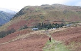
High Rigg is a small fell
located in the English
Lake District
, approximately three miles southeast of the town of Keswick
. It occupies an unusual position, surrounded on all sides by higher fells but not connected by any obvious ridge
. This separation from its fellows ensures that it is a Marilyn
.
, whose high point is Raven Crag
. This forms the watershed between the Shoulthwaite and Thirlmere/ Vale of St John systems. The depression between High Rigg and Raven Crag to the south — at only around 550 ft (167.6 m) — is at Smaithwaite, just south of the A591
Keswick to Ambleside
road.
High Rigg resembles a model of the Lakeland Fells in miniature, complete with crags, intermediate tops, tarns
and even a 'pass' crossing the ridge halfway along, complete with church. The northern and southern aspects of the fell are largely grassed and gently rolling, in contrast to the western and eastern flanks which are steep with numerous rocky outcroppings and cliffs.
Travelling south to north the main features are Wren Crag (1,020 ft), overlooking the Vale of St John, Yew Crag (1,000 ft) facing west and then two tops at 1125 ft (342.9 m) and 1171 ft (356.9 m) respectively. The ridge then falls to the 'pass' and St John's church, before rising again to Low Rigg
(836 ft). Finally comes Tewet Tarn
as the ridge falls away to the river Greta. Also known as Tewfit Tarn, this shallow pool stands on a shelf, overlooked by higher rocks.
overlay much of the fell which lies between two branches of the Coniston Fault, with the plagioclase
-phyric andesite
lavas of the Birker Fell Formation beneath. Low Rigg exhibits intrusions of microgranite to the surface.
set on an outcrop and commands a fine view
of the surrounding fells. The giants of Skiddaw
and Blencathra
dominate the view to the north, and Clough Head
and the Helvellyn range
the view east. Thirlmere is visible to the south and Bleaberry Fell
to the west, over which the Scafell group can be seen on a clear day.

from the Church of St John's in the Vale
. It only involves about 120 m (400 ft) of climb and is one of the shortest ascents in the Lakes. Alternatively, a traverse of the fell's three mile (5 km) long ridge may be made, starting at Tewit Tarn and finishing near Shoulthwaite.
Fell
“Fell” is a word used to refer to mountains, or certain types of mountainous landscape, in Scandinavia, the Isle of Man, and parts of northern England.- Etymology :...
located in the English
England
England is a country that is part of the United Kingdom. It shares land borders with Scotland to the north and Wales to the west; the Irish Sea is to the north west, the Celtic Sea to the south west, with the North Sea to the east and the English Channel to the south separating it from continental...
Lake District
Lake District
The Lake District, also commonly known as The Lakes or Lakeland, is a mountainous region in North West England. A popular holiday destination, it is famous not only for its lakes and its mountains but also for its associations with the early 19th century poetry and writings of William Wordsworth...
, approximately three miles southeast of the town of Keswick
Keswick, Cumbria
Keswick is a market town and civil parish within the Borough of Allerdale in Cumbria, England. It had a population of 4,984, according to the 2001 census, and is situated just north of Derwent Water, and a short distance from Bassenthwaite Lake, both in the Lake District National Park...
. It occupies an unusual position, surrounded on all sides by higher fells but not connected by any obvious ridge
Ridge
A ridge is a geological feature consisting of a chain of mountains or hills that form a continuous elevated crest for some distance. Ridges are usually termed hills or mountains as well, depending on size. There are several main types of ridges:...
. This separation from its fellows ensures that it is a Marilyn
Marilyn (hill)
A Marilyn is a mountain or hill in the United Kingdom, Republic of Ireland or Isle of Man with a relative height of at least 150 metres , regardless of absolute height or other merit...
.
Topography
High Rigg is strictly the continuation of the ridge running up the western shore of ThirlmereThirlmere
Thirlmere is a reservoir in the Borough of Allerdale in Cumbria and the English Lake District. It runs roughly south to north, with a dam at the northern end, and is bordered on the eastern side by the A591 road and on the western side by a minor road....
, whose high point is Raven Crag
Raven Crag
Raven Crag is a fell in the English Lake District. It acts as a superb vantage point for, and backdrop to, views across Thirlmere reservoir.-Topography:...
. This forms the watershed between the Shoulthwaite and Thirlmere/ Vale of St John systems. The depression between High Rigg and Raven Crag to the south — at only around 550 ft (167.6 m) — is at Smaithwaite, just south of the A591
A591 road
The A591 is a major road in Cumbria, in the north-west of England. The stretch of the road between Windermere and Keswick has been voted Britain's Favourite Road.-Route:...
Keswick to Ambleside
Ambleside
Ambleside is a town in Cumbria, in North West England.Historically within the county of Westmorland, it is situated at the head of Windermere, England's largest lake...
road.
High Rigg resembles a model of the Lakeland Fells in miniature, complete with crags, intermediate tops, tarns
Tarn (lake)
A tarn is a mountain lake or pool, formed in a cirque excavated by a glacier. A moraine may form a natural dam below a tarn. A corrie may be called a cirque.The word is derived from the Old Norse word tjörn meaning pond...
and even a 'pass' crossing the ridge halfway along, complete with church. The northern and southern aspects of the fell are largely grassed and gently rolling, in contrast to the western and eastern flanks which are steep with numerous rocky outcroppings and cliffs.
Travelling south to north the main features are Wren Crag (1,020 ft), overlooking the Vale of St John, Yew Crag (1,000 ft) facing west and then two tops at 1125 ft (342.9 m) and 1171 ft (356.9 m) respectively. The ridge then falls to the 'pass' and St John's church, before rising again to Low Rigg
Low Rigg
Low Rigg is a small hill located in the English Lake District a few miles east of the town of Keswick and slightly to the north of its larger neighbour High Rigg. It is a hill of modest elevation, being of insufficient size to merit inclusion in the famous Lake District guides produced by Alfred...
(836 ft). Finally comes Tewet Tarn
Tarn (lake)
A tarn is a mountain lake or pool, formed in a cirque excavated by a glacier. A moraine may form a natural dam below a tarn. A corrie may be called a cirque.The word is derived from the Old Norse word tjörn meaning pond...
as the ridge falls away to the river Greta. Also known as Tewfit Tarn, this shallow pool stands on a shelf, overlooked by higher rocks.
Geology
The geology of the ridge is complex with much small scale faulting. Gravel and screeScree
Scree, also called talus, is a term given to an accumulation of broken rock fragments at the base of crags, mountain cliffs, or valley shoulders. Landforms associated with these materials are sometimes called scree slopes or talus piles...
overlay much of the fell which lies between two branches of the Coniston Fault, with the plagioclase
Plagioclase
Plagioclase is an important series of tectosilicate minerals within the feldspar family. Rather than referring to a particular mineral with a specific chemical composition, plagioclase is a solid solution series, more properly known as the plagioclase feldspar series...
-phyric andesite
Andesite
Andesite is an extrusive igneous, volcanic rock, of intermediate composition, with aphanitic to porphyritic texture. In a general sense, it is the intermediate type between basalt and dacite. The mineral assemblage is typically dominated by plagioclase plus pyroxene and/or hornblende. Magnetite,...
lavas of the Birker Fell Formation beneath. Low Rigg exhibits intrusions of microgranite to the surface.
Summit and view
The summit has a cairnCairn
Cairn is a term used mainly in the English-speaking world for a man-made pile of stones. It comes from the or . Cairns are found all over the world in uplands, on moorland, on mountaintops, near waterways and on sea cliffs, and also in barren desert and tundra areas...
set on an outcrop and commands a fine view
View
A view is what can be seen in a range of vision. View may also be used as a synonym of point of view in the first sense. View may also be used figuratively or with special significance—for example, to imply a scenic outlook or significant vantage point:...
of the surrounding fells. The giants of Skiddaw
Skiddaw
Skiddaw is a mountain in the Lake District National Park in England. With a summit at 931 m above sea level it is the fourth highest mountain in England. It lies just north of the town of Keswick, Cumbria, and dominates the skyline in this part of the northern lakes...
and Blencathra
Blencathra
Blencathra, also known as Saddleback, is one of the most northerly mountains in the English Lake District. It has six separate fell tops, of which the highest is the Hallsfell Top.-Name:...
dominate the view to the north, and Clough Head
Clough Head
Clough Head is a fell in the English Lake District. It is the northernmost top of the Helvellyn range in the Eastern Fells, standing to the south of Threlkeld and the A66.-Topography:...
and the Helvellyn range
Helvellyn range
Helvellyn range is the name given to a part of the Eastern Fells in the English Lake District, fell being the local word for hill. The name comes from Helvellyn, the highest point of the group....
the view east. Thirlmere is visible to the south and Bleaberry Fell
Bleaberry Fell
Bleaberry Fell is a fell in the Lake District in Cumbria, England, with a height of 590 metres . It stands on the main watershed between Borrowdale and Thirlmere and can be climbed from either flank...
to the west, over which the Scafell group can be seen on a clear day.
Ascents
The hill may be climbed in a short twenty-minute walkWALK
WALK may refer to:*WALK , a radio station licensed to East Patchogue, New York, United States*WALK-FM, a radio station licensed to Patchogue, New York, United States...
from the Church of St John's in the Vale
St John's in the Vale
St John's in the Vale is a glacial valley in the Lake District National Park, Cumbria, England. Within the vale are a number of farms and small settlements, in addition to several disused quarry and mining works. St Johns Beck meanders northward along the floor of the vale, and is the primary route...
. It only involves about 120 m (400 ft) of climb and is one of the shortest ascents in the Lakes. Alternatively, a traverse of the fell's three mile (5 km) long ridge may be made, starting at Tewit Tarn and finishing near Shoulthwaite.