

Canaan, New Hampshire
Encyclopedia
Canaan is a town in Grafton County
, New Hampshire
, United States
. The population was 3,909 at the 2010 census. It is the location of Mascoma State Forest. Canaan is home to the Cardigan Mountain School
, the town's largest employer.
The main village of the town, where 524 people resided at the 2010 census, is defined as the Canaan census-designated place
(CDP), and is located at the junction of U.S. Route 4
with New Hampshire Route 118
.
, the town was named after the hometown of many early settlers, Canaan
, Connecticut
, which had been named for the biblical land of Canaan
. It was settled in the winter of 1766-1767 by John Scofield, who arrived with all his belongings on a hand sled
. With an unbroken surface, the town was suited for agriculture
. The Northern Railroad
(predecessor of the Boston & Maine Railroad) arrived in 1847, spurring development. Water powered mills
were built on the streams. By 1859, when the population was 1,682, Canaan had one gristmill
, three lath
and clapboard
mills, and one tannery
.
In March 1835, 28 white students and 14 black students commenced classes at the newly established Noyes Academy
. On August 10, 1835, white residents of Canaan, with the help of neighboring towns and "nearly 100 yoke of oxen," forcibly removed Noyes Academy from its foundation. Later, the community would be a stop on the Underground Railroad
.
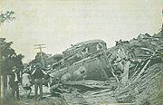
Canaan was the site of a famous train
wreck on September 15, 1907. Four miles north of Canaan Station, the southbound Quebec to Boston express, heavily loaded with passengers returning from the Sherbrooke Fair, collided head-on with a northbound Boston & Maine freight train
. Twenty-five people perished, and an equal number were seriously injured. Cause of the accident was "due to a mistake in train dispatcher's orders."
On June 2, 1923, another disaster destroyed the heart of Canaan Village (East Canaan). The Great Canaan Fire burned 48 homes and businesses.
, the town has a total area of 55 square miles (142.4 km²), of which 53.2 sq mi (137.8 km²) is land and 1.8 sq mi (4.7 km²) is water, comprising 3.31% of the town. Canaan is drained by the Indian River
and Mascoma River
. Canaan Street Lake
is in the center, and Goose Pond
is in the northwest.
The town center lies in the valley of the Indian River (a tributary of the Mascoma River) at the base of Mount Cardigan
, which lies to the east in the neighboring town of Orange
. A mountain road leads from Canaan to a trailhead in Cardigan Mountain State Forest, where hiking trails on the west slope of the mountain lead to the bare-rock summit. The highest point in Canaan is the top of an unnamed ridge (approximately 2270 feet (691.9 m) above sea level
) in the northeast corner of town, overlooking Derby Pond.
Canaan lies almost fully within the Connecticut River
watershed
except for a tiny part of the northeast of the town, which is in the Merrimack River
watershed.
The town is crossed by U.S. Route 4
and New Hampshire Route 118
.
 As of the census
of 2000, there were 3,319 people, 1,279 households, and 929 families residing in the town. The population density
was 62.4 people per square mile (24.1/km²). There were 1,588 housing units at an average density of 29.8 per square mile (11.5/km²). The racial makeup of the town was 98.13% White, 0.12% African American, 0.12% Native American, 0.36% Asian, 0.21% from other races
, and 1.05% from two or more races. Hispanic or Latino of any race were 0.51% of the population.
There were 1,279 households, of which 36.4% had children under the age of 18 living with them, 60.2% were married couples
living together, 8.4% had a female householder with no husband present, and 27.3% were non-families. 21.0% of all households were made up of individuals and 7.5% had someone living alone who was 65 years of age or older. The average household size was 2.59 and the average family size was 3.00.
In the town, the population was spread out with 27.0% under the age of 18, 5.9% from 18 to 24, 31.3% from 25 to 44, 26.1% from 45 to 64, and 9.7% who were 65 years of age or older. The median age was 38 years. For every 100 females there were 96.0 males. For every 100 females age 18 and over, there were 93.8 males.
The median income for a household in the town was $43,220, and the median income for a family was $46,339. Males had a median income of $32,946 versus $25,000 for females. The per capita income
for the town was $20,515. About 2.9% of families and 6.0% of the population were below the poverty line, including 4.6% of those under age 18 and 12.4% of those age 65 or over.
Grafton County, New Hampshire
Grafton County is a county located in the U.S. state of New Hampshire. As of the 2010 census, the population was 89,118. Its county seat is North Haverhill, which is a village within the town of Haverhill. Until 1972, the county courthouse and other offices were located in downtown Woodsville, a...
, New Hampshire
New Hampshire
New Hampshire is a state in the New England region of the northeastern United States of America. The state was named after the southern English county of Hampshire. It is bordered by Massachusetts to the south, Vermont to the west, Maine and the Atlantic Ocean to the east, and the Canadian...
, United States
United States
The United States of America is a federal constitutional republic comprising fifty states and a federal district...
. The population was 3,909 at the 2010 census. It is the location of Mascoma State Forest. Canaan is home to the Cardigan Mountain School
Cardigan Mountain School
Cardigan Mountain School is a boys-only independent boarding school located on 62 Alumni Drive, Canaan, New Hampshire, USA. It was founded in 1945 on land provided by Dartmouth College....
, the town's largest employer.
The main village of the town, where 524 people resided at the 2010 census, is defined as the Canaan census-designated place
Census-designated place
A census-designated place is a concentration of population identified by the United States Census Bureau for statistical purposes. CDPs are delineated for each decennial census as the statistical counterparts of incorporated places such as cities, towns and villages...
(CDP), and is located at the junction of U.S. Route 4
U.S. Route 4
U.S. Route 4 is a long United States highway that runs from East Greenbush, New York, in the west to Portsmouth, New Hampshire, in the east, traversing through Vermont.In New York, US 4 is signed north–south to reflect its alignment in the state...
with New Hampshire Route 118
New Hampshire Route 118
New Hampshire Route 118 is a long secondary north–south highway in Grafton County, New Hampshire. NH 118 stretches from Woodstock, in the White Mountains Region, south to Canaan in the Upper Valley region....
.
History
Chartered in 1761 by Governor Benning WentworthBenning Wentworth
Benning Wentworth was the colonial governor of New Hampshire from 1741 to 1766.-Biography:The eldest child of the John Wentworth who had been Lieutenant Governor, he was born and died in Portsmouth, New Hampshire. Wentworth graduated from Harvard College in 1715...
, the town was named after the hometown of many early settlers, Canaan
Canaan, Connecticut
Canaan is a town in Litchfield County, Connecticut, United States. The population was 1,081 at the 2000 census. The town of Canaan is often referred to locally by the name of its principal constituent village, Falls Village.-Geography:...
, Connecticut
Connecticut
Connecticut is a state in the New England region of the northeastern United States. It is bordered by Rhode Island to the east, Massachusetts to the north, and the state of New York to the west and the south .Connecticut is named for the Connecticut River, the major U.S. river that approximately...
, which had been named for the biblical land of Canaan
Canaan
Canaan is a historical region roughly corresponding to modern-day Israel, Palestine, Lebanon, and the western parts of Jordan...
. It was settled in the winter of 1766-1767 by John Scofield, who arrived with all his belongings on a hand sled
Sled
A sled, sledge, or sleigh is a land vehicle with a smooth underside or possessing a separate body supported by two or more smooth, relatively narrow, longitudinal runners that travels by sliding across a surface. Most sleds are used on surfaces with low friction, such as snow or ice. In some cases,...
. With an unbroken surface, the town was suited for agriculture
Agriculture
Agriculture is the cultivation of animals, plants, fungi and other life forms for food, fiber, and other products used to sustain life. Agriculture was the key implement in the rise of sedentary human civilization, whereby farming of domesticated species created food surpluses that nurtured the...
. The Northern Railroad
Northern Rail Trail (New Hampshire)
The Northern Rail Trail is a multi-use rail trail in western New Hampshire, currently in length from Lebanon to Grafton. Another section runs from Franklin to Andover, and construction on the Andover-Grafton section was underway in 2010. It uses the right of way of Boston & Maine's former Northern...
(predecessor of the Boston & Maine Railroad) arrived in 1847, spurring development. Water powered mills
Watermill
A watermill is a structure that uses a water wheel or turbine to drive a mechanical process such as flour, lumber or textile production, or metal shaping .- History :...
were built on the streams. By 1859, when the population was 1,682, Canaan had one gristmill
Gristmill
The terms gristmill or grist mill can refer either to a building in which grain is ground into flour, or to the grinding mechanism itself.- Early history :...
, three lath
Lath
A lath is a thin, narrow strip of some straight-grained wood or other material, including metal or gypsum. A lattice, or lattice-work, is a criss-crossed or interlaced arrangement of laths, or the pattern made by such an arrangement...
and clapboard
Clapboard (architecture)
Clapboard, also known as bevel siding or lap siding or weather-board , is a board used typically for exterior horizontal siding that has one edge thicker than the other and where the board above laps over the one below...
mills, and one tannery
Tanning
Tanning is the making of leather from the skins of animals which does not easily decompose. Traditionally, tanning used tannin, an acidic chemical compound from which the tanning process draws its name . Coloring may occur during tanning...
.
In March 1835, 28 white students and 14 black students commenced classes at the newly established Noyes Academy
Noyes Academy
Noyes Academy was an experimental interracial school founded in 1835 in Canaan, New Hampshire, USA. The school was demolished in less than a year by opponents of interracial education....
. On August 10, 1835, white residents of Canaan, with the help of neighboring towns and "nearly 100 yoke of oxen," forcibly removed Noyes Academy from its foundation. Later, the community would be a stop on the Underground Railroad
Underground Railroad
The Underground Railroad was an informal network of secret routes and safe houses used by 19th-century black slaves in the United States to escape to free states and Canada with the aid of abolitionists and allies who were sympathetic to their cause. The term is also applied to the abolitionists,...
.
Canaan was the site of a famous train
Train
A train is a connected series of vehicles for rail transport that move along a track to transport cargo or passengers from one place to another place. The track usually consists of two rails, but might also be a monorail or maglev guideway.Propulsion for the train is provided by a separate...
wreck on September 15, 1907. Four miles north of Canaan Station, the southbound Quebec to Boston express, heavily loaded with passengers returning from the Sherbrooke Fair, collided head-on with a northbound Boston & Maine freight train
Freight train
A freight train or goods train is a group of freight cars or goods wagons hauled by one or more locomotives on a railway, ultimately transporting cargo between two points as part of the logistics chain...
. Twenty-five people perished, and an equal number were seriously injured. Cause of the accident was "due to a mistake in train dispatcher's orders."
On June 2, 1923, another disaster destroyed the heart of Canaan Village (East Canaan). The Great Canaan Fire burned 48 homes and businesses.
Geography
According to the United States Census BureauUnited States Census Bureau
The United States Census Bureau is the government agency that is responsible for the United States Census. It also gathers other national demographic and economic data...
, the town has a total area of 55 square miles (142.4 km²), of which 53.2 sq mi (137.8 km²) is land and 1.8 sq mi (4.7 km²) is water, comprising 3.31% of the town. Canaan is drained by the Indian River
Indian River (New Hampshire)
The Indian River is a 12.8 mile long river located in western New Hampshire in the United States. The river is a tributary of the Mascoma River, which in turn flows to the Connecticut River and ultimately Long Island Sound....
and Mascoma River
Mascoma River
The Mascoma River is a 31.6 mile long river located in western New Hampshire in the United States. It is a tributary of the Connecticut River, which flows to Long Island Sound. The Mascoma comprises two sections which are split by Mascoma Lake in the communities of Enfield and Lebanon...
. Canaan Street Lake
Canaan Street Lake
Canaan Street Lake is a water body located in Grafton County in western New Hampshire, United States, in the town of Canaan. It is part of the Mascoma River watershed, a tributary of the Connecticut River....
is in the center, and Goose Pond
Goose Pond
Goose Pond is a water body located in Grafton County in western New Hampshire, United States, in the towns of Canaan and Hanover. The lake is part of the Mascoma River watershed, flowing to the Connecticut River....
is in the northwest.
The town center lies in the valley of the Indian River (a tributary of the Mascoma River) at the base of Mount Cardigan
Mount Cardigan
Mount Cardigan is a prominent bare-rock summit in the towns of Orange and Alexandria in western New Hampshire. While its peak is only above sea level, it has extensive areas of bare granite ledges and alpine scrub, giving it the feel to hikers of a much higher mountain...
, which lies to the east in the neighboring town of Orange
Orange, New Hampshire
Orange is a town in Grafton County, New Hampshire, United States. The population was 331 at the 2010 census.- History :Orange was granted in 1769 and incorporated in 1790. It was originally named Cardigan, after George Brudenell, fourth Earl of Cardigan. The Cardigan name lives on with Mount...
. A mountain road leads from Canaan to a trailhead in Cardigan Mountain State Forest, where hiking trails on the west slope of the mountain lead to the bare-rock summit. The highest point in Canaan is the top of an unnamed ridge (approximately 2270 feet (691.9 m) above sea level
Sea level
Mean sea level is a measure of the average height of the ocean's surface ; used as a standard in reckoning land elevation...
) in the northeast corner of town, overlooking Derby Pond.
Canaan lies almost fully within the Connecticut River
Connecticut River
The Connecticut River is the largest and longest river in New England, and also an American Heritage River. It flows roughly south, starting from the Fourth Connecticut Lake in New Hampshire. After flowing through the remaining Connecticut Lakes and Lake Francis, it defines the border between the...
watershed
Drainage basin
A drainage basin is an extent or an area of land where surface water from rain and melting snow or ice converges to a single point, usually the exit of the basin, where the waters join another waterbody, such as a river, lake, reservoir, estuary, wetland, sea, or ocean...
except for a tiny part of the northeast of the town, which is in the Merrimack River
Merrimack River
The Merrimack River is a river in the northeastern United States. It rises at the confluence of the Pemigewasset and Winnipesaukee rivers in Franklin, New Hampshire, flows southward into Massachusetts, and then flows northeast until it empties into the Atlantic Ocean at Newburyport...
watershed.
The town is crossed by U.S. Route 4
U.S. Route 4 in New Hampshire
In the state of New Hampshire, U.S. Route 4 runs for across the central and southern part of the state, stretching from Lebanon on the Connecticut River border with Vermont southeast to Portsmouth on the eastern coast.-Route description:U.S...
and New Hampshire Route 118
New Hampshire Route 118
New Hampshire Route 118 is a long secondary north–south highway in Grafton County, New Hampshire. NH 118 stretches from Woodstock, in the White Mountains Region, south to Canaan in the Upper Valley region....
.
Demographics
Census
A census is the procedure of systematically acquiring and recording information about the members of a given population. It is a regularly occurring and official count of a particular population. The term is used mostly in connection with national population and housing censuses; other common...
of 2000, there were 3,319 people, 1,279 households, and 929 families residing in the town. The population density
Population density
Population density is a measurement of population per unit area or unit volume. It is frequently applied to living organisms, and particularly to humans...
was 62.4 people per square mile (24.1/km²). There were 1,588 housing units at an average density of 29.8 per square mile (11.5/km²). The racial makeup of the town was 98.13% White, 0.12% African American, 0.12% Native American, 0.36% Asian, 0.21% from other races
Race (United States Census)
Race and ethnicity in the United States Census, as defined by the Federal Office of Management and Budget and the United States Census Bureau, are self-identification data items in which residents choose the race or races with which they most closely identify, and indicate whether or not they are...
, and 1.05% from two or more races. Hispanic or Latino of any race were 0.51% of the population.
There were 1,279 households, of which 36.4% had children under the age of 18 living with them, 60.2% were married couples
Marriage
Marriage is a social union or legal contract between people that creates kinship. It is an institution in which interpersonal relationships, usually intimate and sexual, are acknowledged in a variety of ways, depending on the culture or subculture in which it is found...
living together, 8.4% had a female householder with no husband present, and 27.3% were non-families. 21.0% of all households were made up of individuals and 7.5% had someone living alone who was 65 years of age or older. The average household size was 2.59 and the average family size was 3.00.
In the town, the population was spread out with 27.0% under the age of 18, 5.9% from 18 to 24, 31.3% from 25 to 44, 26.1% from 45 to 64, and 9.7% who were 65 years of age or older. The median age was 38 years. For every 100 females there were 96.0 males. For every 100 females age 18 and over, there were 93.8 males.
The median income for a household in the town was $43,220, and the median income for a family was $46,339. Males had a median income of $32,946 versus $25,000 for females. The per capita income
Per capita income
Per capita income or income per person is a measure of mean income within an economic aggregate, such as a country or city. It is calculated by taking a measure of all sources of income in the aggregate and dividing it by the total population...
for the town was $20,515. About 2.9% of families and 6.0% of the population were below the poverty line, including 4.6% of those under age 18 and 12.4% of those age 65 or over.
Sites of interest
- Canaan Historical Museum
- Northern Rail TrailNorthern Rail Trail (New Hampshire)The Northern Rail Trail is a multi-use rail trail in western New Hampshire, currently in length from Lebanon to Grafton. Another section runs from Franklin to Andover, and construction on the Andover-Grafton section was underway in 2010. It uses the right of way of Boston & Maine's former Northern...
Notable inhabitants
- Daniel BlaisdellDaniel BlaisdellDaniel Blaisdell was a United States Representative from New Hampshire. He was born in Amesbury, Massachusetts and attended the public schools there. He served in the American Revolutionary War from August 1776 to August 1777...
, congressman - Henry G. BurleighHenry G. BurleighHenry Gordon Burleigh was a United States Representative from New York.Born in Canaan, New Hampshire, Burleigh attended the common schools. He moved to New York in 1846 with his parents, who settled in Ticonderoga. He engaged in the mining of iron ore and in the lumber, coal, and transportation...
, congressman representing New York - Frank Dunklee CurrierFrank Dunklee CurrierFrank Dunklee Currier was a U.S. Representative from New Hampshire.Born in Canaan, New Hampshire, Currier attended the common schools, then Kimball Union Academy in Meriden, New Hampshire, and Doctor Hixon's School in Lowell, Massachusetts...
, congressman - Joshua SmithJoshua Smith (minister)Joshua Smith was an early American hymn compiler and Baptist minister in New Hampshire, USA.Smith was born in 1760 and was a Baptist lay minister in New Hampshire. Smith authored Divine Hymns, or Spiritual Songs, a book of hymns first published in either 1784 or 1791 featuring and popularizing...
, author of Divine Hymns, or Spiritual Songs