

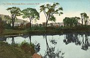
Mascoma River
Encyclopedia
New Hampshire
New Hampshire is a state in the New England region of the northeastern United States of America. The state was named after the southern English county of Hampshire. It is bordered by Massachusetts to the south, Vermont to the west, Maine and the Atlantic Ocean to the east, and the Canadian...
in the United States. It is a tributary
Tributary
A tributary or affluent is a stream or river that flows into a main stem river or a lake. A tributary does not flow directly into a sea or ocean...
of the Connecticut River
Connecticut River
The Connecticut River is the largest and longest river in New England, and also an American Heritage River. It flows roughly south, starting from the Fourth Connecticut Lake in New Hampshire. After flowing through the remaining Connecticut Lakes and Lake Francis, it defines the border between the...
, which flows to Long Island Sound
Long Island Sound
Long Island Sound is an estuary of the Atlantic Ocean, located in the United States between Connecticut to the north and Long Island, New York to the south. The mouth of the Connecticut River at Old Saybrook, Connecticut, empties into the sound. On its western end the sound is bounded by the Bronx...
. The Mascoma comprises two sections which are split by Mascoma Lake
Mascoma Lake
Mascoma Lake is a lake in western New Hampshire, United States. Most of the lake is located within the town of Enfield, while a small portion is within the city of Lebanon, where it drains into the Mascoma River, a tributary of the Connecticut River....
in the communities of Enfield
Enfield, New Hampshire
Enfield is a town in Grafton County, New Hampshire, United States. The population was 4,582 at the 2010 census. The town includes the villages of Enfield, Enfield Center, Upper Shaker Village, Lower Shaker Village, Lockehaven, and Montcalm....
and Lebanon
Lebanon, New Hampshire
As of the census of 2000, there were 12,568 people, 5,500 households, and 3,178 families residing in the city. The population density was 311.4 people per square mile . There were 5,707 housing units at an average density of 141.4 per square mile...
. Counting the lake would add 2.7 miles (4.4 km) to the river's length.
The Mascoma River begins at Cummins Pond in a heavily-forested part of the town of Dorchester, New Hampshire
Dorchester, New Hampshire
Dorchester is a town in Grafton County, New Hampshire, United States. The population was 355 at the 2010 census.-History:Originally granted by Governor Benning Wentworth in 1761, Dorchester was named for Dorchester in Dorset, England. When the recipients failed to take up the grant, it was...
and flows south into the town of Canaan
Canaan, New Hampshire
Canaan is a town in Grafton County, New Hampshire, United States. The population was 3,909 at the 2010 census. It is the location of Mascoma State Forest...
, collecting water flowing from Reservoir Pond, Clark Pond, and Canaan Street Lake
Canaan Street Lake
Canaan Street Lake is a water body located in Grafton County in western New Hampshire, United States, in the town of Canaan. It is part of the Mascoma River watershed, a tributary of the Connecticut River....
before reaching the Indian River
Indian River (New Hampshire)
The Indian River is a 12.8 mile long river located in western New Hampshire in the United States. The river is a tributary of the Mascoma River, which in turn flows to the Connecticut River and ultimately Long Island Sound....
. Here it turns west, collecting tributaries arriving from Goose Pond
Goose Pond
Goose Pond is a water body located in Grafton County in western New Hampshire, United States, in the towns of Canaan and Hanover. The lake is part of the Mascoma River watershed, flowing to the Connecticut River....
and Crystal Lake
Crystal Lake (Enfield, New Hampshire)
Crystal Lake is a water body located in Grafton County in western New Hampshire, United States, in the town of Enfield. Crystal Lake is part of the Mascoma River watershed.The lake contains one small island: Oliver Island....
, before it passes through the mill town
Mill town
A mill town, also known as factory town or mill village, is typically a settlement that developed around one or more mills or factories .- United Kingdom:...
of Enfield and arrives at Mascoma Lake.
At the western end of Mascoma Lake, the Mascoma River, now in Lebanon, drops quickly over rapids and occasional falls
Waterfall
A waterfall is a place where flowing water rapidly drops in elevation as it flows over a steep region or a cliff.-Formation:Waterfalls are commonly formed when a river is young. At these times the channel is often narrow and deep. When the river courses over resistant bedrock, erosion happens...
, passing numerous small hydroelectric dams in the center of Lebanon and on its way to West Lebanon
West Lebanon, New Hampshire
West Lebanon, New Hampshire, is a district within the city of Lebanon on the Connecticut River. The area contains a major shopping plaza strip along New Hampshire Route 12A, serving the Upper Valley communities along Interstates 89 and 91...
, where it reaches the Connecticut River. The section of the river immediately downstream of the Mascoma Lake dam is reserved for fly fishing only, while other portions of the river are open for all types of fisherman. The river is stocked by the New Hampshire Fish and Game Department.
For most of its path from the Indian River to the Connecticut, the Mascoma River and its valley have influenced the location of numerous transportation routes, including U.S. Route 4
U.S. Route 4
U.S. Route 4 is a long United States highway that runs from East Greenbush, New York, in the west to Portsmouth, New Hampshire, in the east, traversing through Vermont.In New York, US 4 is signed north–south to reflect its alignment in the state...
and an inactive, state-owned rail line known as the Northern Railroad, which has now been converted in some areas to a "rail trail
Rail trail
A rail trail is the conversion of a disused railway easement into a multi-use path, typically for walking, cycling and sometimes horse riding. The characteristics of former tracks—flat, long, frequently running through historical areas—are appealing for various development. The term sometimes also...
" bike path.