
Campton, New Hampshire
Encyclopedia
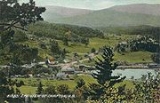
Campton is a town in Grafton County
, New Hampshire
, United States
. The population was 3,333 at the 2010 census. Campton, which includes the villages of Blair, Campton Hollow, Lower Campton and West Campton, is home to Blair State Forest and Livermore Falls State Forest. It is located in the foothills
of the White Mountains
, and parts of the White Mountain National Forest
are in the northeast.
were granted by Governor Benning Wentworth
in 1761 to Jabez Spencer of East Haddam
, Connecticut
, then settled about 1765. But Captain Spencer died before terms of the charter, which required settlement by 50 families, each farming 5 acres (20,234.3 m²) for every 50 received, were fulfilled. In 1767, Governor John Wentworth
issued the heirs and others a new grant. Campton got its name when the first proprietors built a camp
here to survey
the two towns.
Although the surface is mountainous and ledgy, farmer
s found good soil for cultivation
in the intervales along the rivers. By 1859, when the population was 1,439, industries included one sawmill
, one gristmill
, one tannery
and a carriage
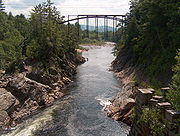
shop. Sylvester Marsh, builder of the Mount Washington Cog Railway, had his boyhood home in Campton. The town has three covered bridge
s, including Blair Bridge
, which is 292 feet (89 m), 10 inches long, making it the second longest of those entirely within the state.
 According to the United States Census Bureau
, the town has a total area of 52.5 square miles (136 km²), of which 51.9 sq mi (134.4 km²) is land and 0.6 sq mi (1.6 km²) is water, comprising 1.12% of the town. The highest point in Campton is Mount Weetamoo, at 2548 feet (776.6 m) above sea level
. The town is drained by the Mad River and Pemigewasset River
. Campton lies fully within the Merrimack River
watershed
.
The town is crossed by Interstate 93
, U.S. Route 3, New Hampshire Route 49
and New Hampshire Route 175
.
of 2000, there were 2,719 people, 1,128 households, and 759 families residing in the town. The population density
was 52.4 people per square mile (20.2/km²). There were 1,759 housing units at an average density of 33.9 per square mile (13.1/km²). The racial makeup of the town was 98.01% White, 0.04% African American, 0.04% Native American, 0.70% Asian, 0.15% Pacific Islander, and 1.07% from two or more races. Hispanic or Latino of any race were 0.40% of the population.
There were 1,128 households out of which 30.2% had children under the age of 18 living with them, 54.8% were married couples
living together, 8.2% had a female householder with no husband present, and 32.7% were non-families. 25.0% of all households were made up of individuals and 8.2% had someone living alone who was 65 years of age or older. The average household size was 2.41 and the average family size was 2.89.
In the town the population was spread out with 23.8% under the age of 18, 7.2% from 18 to 24, 30.0% from 25 to 44, 27.0% from 45 to 64, and 11.9% who were 65 years of age or older. The median age was 39 years. For every 100 females there were 99.9 males. For every 100 females age 18 and over, there were 100.1 males.
The median income for a household in the town was $39,213, and the median income for a family was $46,492. Males had a median income of $30,640 versus $24,688 for females. The per capita income
for the town was $20,189. About 5.8% of families and 8.8% of the population were below the poverty line, including 9.1% of those under age 18 and 8.5% of those age 65 or over.
Grafton County, New Hampshire
Grafton County is a county located in the U.S. state of New Hampshire. As of the 2010 census, the population was 89,118. Its county seat is North Haverhill, which is a village within the town of Haverhill. Until 1972, the county courthouse and other offices were located in downtown Woodsville, a...
, New Hampshire
New Hampshire
New Hampshire is a state in the New England region of the northeastern United States of America. The state was named after the southern English county of Hampshire. It is bordered by Massachusetts to the south, Vermont to the west, Maine and the Atlantic Ocean to the east, and the Canadian...
, United States
United States
The United States of America is a federal constitutional republic comprising fifty states and a federal district...
. The population was 3,333 at the 2010 census. Campton, which includes the villages of Blair, Campton Hollow, Lower Campton and West Campton, is home to Blair State Forest and Livermore Falls State Forest. It is located in the foothills
Foothills
Foothills are geographically defined as gradual increases in elevation at the base of a mountain range. They are a transition zone between plains and low relief hills to the adjacent topographically high mountains.-Examples:...
of the White Mountains
White Mountains (New Hampshire)
The White Mountains are a mountain range covering about a quarter of the state of New Hampshire and a small portion of western Maine in the United States. Part of the Appalachian Mountains, they are considered the most rugged mountains in New England...
, and parts of the White Mountain National Forest
White Mountain National Forest
The White Mountain National Forest is a federally-managed forest contained within the White Mountains in the northeastern United States. It was established in 1918 as a result of the Weeks Act of 1911; federal acquisition of land had already begun in 1914. It has a total area of...
are in the northeast.
History
Both Campton and adjacent RumneyRumney, New Hampshire
Rumney is a town in Grafton County, New Hampshire, United States. The population was 1,480 at the 2010 census. The town is located at the southern edge of the White Mountain National Forest.-History:...
were granted by Governor Benning Wentworth
Benning Wentworth
Benning Wentworth was the colonial governor of New Hampshire from 1741 to 1766.-Biography:The eldest child of the John Wentworth who had been Lieutenant Governor, he was born and died in Portsmouth, New Hampshire. Wentworth graduated from Harvard College in 1715...
in 1761 to Jabez Spencer of East Haddam
East Haddam, Connecticut
East Haddam is a town in Middlesex County, Connecticut, United States. The population was 8,333 at the 2000 census.-Geography:According to the United States Census Bureau, the town has a total area of , of which, of it is land and of it is water....
, Connecticut
Connecticut
Connecticut is a state in the New England region of the northeastern United States. It is bordered by Rhode Island to the east, Massachusetts to the north, and the state of New York to the west and the south .Connecticut is named for the Connecticut River, the major U.S. river that approximately...
, then settled about 1765. But Captain Spencer died before terms of the charter, which required settlement by 50 families, each farming 5 acres (20,234.3 m²) for every 50 received, were fulfilled. In 1767, Governor John Wentworth
John Wentworth (governor)
Sir John Wentworth, 1st Baronet was the British colonial governor of New Hampshire at the time of the American Revolution. He was later also Lieutenant-Governor of Nova Scotia.-Early life:...
issued the heirs and others a new grant. Campton got its name when the first proprietors built a camp
Campsite
A campsite or camping pitch is a place used for overnight stay in the outdoors. In British English a campsite is an area, usually divided into a number of pitches, where people can camp overnight using tents or camper vans or caravans; this British English use of the word is synonymous with the...
here to survey
Surveying
See Also: Public Land Survey SystemSurveying or land surveying is the technique, profession, and science of accurately determining the terrestrial or three-dimensional position of points and the distances and angles between them...
the two towns.
Although the surface is mountainous and ledgy, farmer
Farmer
A farmer is a person engaged in agriculture, who raises living organisms for food or raw materials, generally including livestock husbandry and growing crops, such as produce and grain...
s found good soil for cultivation
Tillage
Tillage is the agricultural preparation of the soil by mechanical agitation of various types, such as digging, stirring, and overturning. Examples of human-powered tilling methods using hand tools include shovelling, picking, mattock work, hoeing, and raking...
in the intervales along the rivers. By 1859, when the population was 1,439, industries included one sawmill
Sawmill
A sawmill is a facility where logs are cut into boards.-Sawmill process:A sawmill's basic operation is much like those of hundreds of years ago; a log enters on one end and dimensional lumber exits on the other end....
, one gristmill
Gristmill
The terms gristmill or grist mill can refer either to a building in which grain is ground into flour, or to the grinding mechanism itself.- Early history :...
, one tannery
Tanning
Tanning is the making of leather from the skins of animals which does not easily decompose. Traditionally, tanning used tannin, an acidic chemical compound from which the tanning process draws its name . Coloring may occur during tanning...
and a carriage
Carriage
A carriage is a wheeled vehicle for people, usually horse-drawn; litters and sedan chairs are excluded, since they are wheelless vehicles. The carriage is especially designed for private passenger use and for comfort or elegance, though some are also used to transport goods. It may be light,...
shop. Sylvester Marsh, builder of the Mount Washington Cog Railway, had his boyhood home in Campton. The town has three covered bridge
Covered bridge
A covered bridge is a bridge with enclosed sides and a roof, often accommodating only a single lane of traffic. Most covered bridges are wooden; some newer ones are concrete or metal with glass sides...
s, including Blair Bridge
Blair Bridge (New Hampshire)
The Blair Bridge is a wooden covered bridge originally built in 1829, that crosses the Pemigewasset River near Campton, New Hampshire, USA. It connects New Hampshire Route 175 to the east and U.S. Route 3 and Interstate 93 to the west...
, which is 292 feet (89 m), 10 inches long, making it the second longest of those entirely within the state.
Notable inhabitants
- Henry W. BlairHenry W. BlairHenry William Blair was a United States Representative and Senator from New Hampshire. Born in Campton, he attended the common schools and private academies, studied law, was admitted to the bar in 1859 and commenced practice in Plymouth...
, congressman and senator - Chris Devlin-YoungChris Devlin-YoungChristopher Devlin-Young is an American alpine ski racer and two time Paralympic Champion, who resides in Campton, New Hampshire...
, ski racer - Arthur LivermoreArthur LivermoreArthur Livermore was a United States Representative from New Hampshire. He was the son of Samuel Livermore and brother of Edward St. Loe Livermore, both of whom served in the United States Congress. He was born in Londonderry, New Hampshire. He received classical instruction from his parents and...
, congressman
Geography
United States Census Bureau
The United States Census Bureau is the government agency that is responsible for the United States Census. It also gathers other national demographic and economic data...
, the town has a total area of 52.5 square miles (136 km²), of which 51.9 sq mi (134.4 km²) is land and 0.6 sq mi (1.6 km²) is water, comprising 1.12% of the town. The highest point in Campton is Mount Weetamoo, at 2548 feet (776.6 m) above sea level
Sea level
Mean sea level is a measure of the average height of the ocean's surface ; used as a standard in reckoning land elevation...
. The town is drained by the Mad River and Pemigewasset River
Pemigewasset River
The Pemigewasset River , known locally as "The Pemi", is a river in the state of New Hampshire, the United States. It is in length and drains approximately...
. Campton lies fully within the Merrimack River
Merrimack River
The Merrimack River is a river in the northeastern United States. It rises at the confluence of the Pemigewasset and Winnipesaukee rivers in Franklin, New Hampshire, flows southward into Massachusetts, and then flows northeast until it empties into the Atlantic Ocean at Newburyport...
watershed
Drainage basin
A drainage basin is an extent or an area of land where surface water from rain and melting snow or ice converges to a single point, usually the exit of the basin, where the waters join another waterbody, such as a river, lake, reservoir, estuary, wetland, sea, or ocean...
.
The town is crossed by Interstate 93
Interstate 93
Interstate 93 is an Interstate Highway in the New England section of the United States. Its southern terminus is in Canton, Massachusetts, in the Boston metropolitan area, at Interstate 95; its northern terminus is near St. Johnsbury, Vermont, at Interstate 91...
, U.S. Route 3, New Hampshire Route 49
New Hampshire Route 49
New Hampshire Route 49 is a long east–west state highway in Grafton County, within the White Mountains in central New Hampshire. It runs from Campton to Waterville Valley....
and New Hampshire Route 175
New Hampshire Route 175
New Hampshire Route 175 is a long north–south state highway in Grafton County in central New Hampshire. The highway winds from Holderness in the Lakes Region, north along the Pemigewasset River, to Woodstock in the White Mountains Region...
.
Demographics
As of the censusCensus
A census is the procedure of systematically acquiring and recording information about the members of a given population. It is a regularly occurring and official count of a particular population. The term is used mostly in connection with national population and housing censuses; other common...
of 2000, there were 2,719 people, 1,128 households, and 759 families residing in the town. The population density
Population density
Population density is a measurement of population per unit area or unit volume. It is frequently applied to living organisms, and particularly to humans...
was 52.4 people per square mile (20.2/km²). There were 1,759 housing units at an average density of 33.9 per square mile (13.1/km²). The racial makeup of the town was 98.01% White, 0.04% African American, 0.04% Native American, 0.70% Asian, 0.15% Pacific Islander, and 1.07% from two or more races. Hispanic or Latino of any race were 0.40% of the population.
There were 1,128 households out of which 30.2% had children under the age of 18 living with them, 54.8% were married couples
Marriage
Marriage is a social union or legal contract between people that creates kinship. It is an institution in which interpersonal relationships, usually intimate and sexual, are acknowledged in a variety of ways, depending on the culture or subculture in which it is found...
living together, 8.2% had a female householder with no husband present, and 32.7% were non-families. 25.0% of all households were made up of individuals and 8.2% had someone living alone who was 65 years of age or older. The average household size was 2.41 and the average family size was 2.89.
In the town the population was spread out with 23.8% under the age of 18, 7.2% from 18 to 24, 30.0% from 25 to 44, 27.0% from 45 to 64, and 11.9% who were 65 years of age or older. The median age was 39 years. For every 100 females there were 99.9 males. For every 100 females age 18 and over, there were 100.1 males.
The median income for a household in the town was $39,213, and the median income for a family was $46,492. Males had a median income of $30,640 versus $24,688 for females. The per capita income
Per capita income
Per capita income or income per person is a measure of mean income within an economic aggregate, such as a country or city. It is calculated by taking a measure of all sources of income in the aggregate and dividing it by the total population...
for the town was $20,189. About 5.8% of families and 8.8% of the population were below the poverty line, including 9.1% of those under age 18 and 8.5% of those age 65 or over.
Sites of interest
- Blair Bridge (1829, rebuilt 1870)Blair Bridge (New Hampshire)The Blair Bridge is a wooden covered bridge originally built in 1829, that crosses the Pemigewasset River near Campton, New Hampshire, USA. It connects New Hampshire Route 175 to the east and U.S. Route 3 and Interstate 93 to the west...
- Town House (1855), Campton Historical Society