
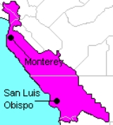
California's 15th State Senate district
Encyclopedia
California's 15th State Senate district is one of 40 California State Senate
districts. It was most recently represented by Republican
Abel Maldonado
of Santa Maria
, who resigned on April 27, 2010, to become Lieutenant Governor of California
. In August 2010, Sam Blakeslee
was elected in a special election to fill the vacancy.
of California
. The district includes one of the longest stretches of coastline, from Santa Cruz
to just into Santa Barbara County. The district has a relatively small minority population due to the division of Monterey County
.
The 15th includes all or portions of five counties, with no one county contributing more than a quarter of the district's population. San Luis Obispo County
is entirely in the district, along with the city of Santa Maria
in Santa Barbara County
.
State Route 1
connects San Luis Obispo with Monterey County
. The western sections of the county, including the city of Monterey
and all of Monterey Bay, are in the district, but the county's largest city, Salinas
, is not. The district also includes the southeastern edge of Santa Cruz County
, specifically the cities of Watsonville
, and Scotts Valley
.
Lastly, a small area in the southern edge of Santa Clara County
is in the 15th, including the cities of Saratoga
, Los Gatos
, and Morgan Hill
, as well as a portion of San Jose
.
The district is one of the more competitive districts in the state. A large Democratic margin in Santa Cruz County is offset by a large Republican margin in San Luis Obispo County.
The district includes the following communities:
Monterey County
San Luis Obispo County
All
Santa Barbara County
Santa Clara County
Santa Cruz County
The district covers all of ZIP code
s 93401, 93402, 93403, 93405, 93406, 93407, 93408, 93409, 93410, 93412, 93420, 93421, 93422, 93423, 93424, 93426, 93428, 93430, 93432, 93432, 93435, 93442, 93443, 93444, 93445, 93446, 93447, 93448, 93449, 93450, 93451, 93452, 93453, 93456, 93458, 93461, 93465, 93483, 93920, 93921, 93922, 93923, 93924, 93928, 93932, 93933, 93940, 93942, 93943, 93944, 93950, 93953, 93954, 93955, 95019, 95020, 95026, 95030, 95031, 95038, 95039, 95041, 95042, 95044, 95066, 95067, 95071, 95076, 95077, 95120, 95141 and 95160; as well as portions of zip codes 93252, 93434, 93454, 93455, 93901, 93906, 93907, 93908, 93926, 93927, 93930, 93960, 93962, 95003, 95004, 95008, 95012, 95013, 95014, 95032, 95033, 95037, 95046, 95060, 95064, 95065, 95070, 95073, 95118, 95119, 95121, 95123, 95124, 95129, 95130, 95135, 95138.
removed from the east along with Salinas and large portions of eastern Santa Clara and Monterey Counties. San Luis Obispo County and the Santa Maria area of Santa Barbara County were added, pushing the district distinctly southward.
California State Senate
The California State Senate is the upper house of the California State Legislature. There are 40 state senators. The state legislature meets in the California State Capitol in Sacramento. The Lieutenant Governor is the ex officio President of the Senate and may break a tied vote...
districts. It was most recently represented by Republican
California Republican Party
The California Republican Party is the California affiliate of the United States Republican Party. The party chairman is Tom Del Beccaro and is based in Burbank, California, a suburb of Los Angeles. The RPC also has a headquarters in Sacramento....
Abel Maldonado
Abel Maldonado
Abel Maldonado is an American politician who was the 48th Lieutenant Governor of California. On November 23, 2009, then-Governor Arnold Schwarzenegger announced Maldonado as his nominee for Lieutenant Governor to fill the vacancy created by John Garamendi's election to the United States House of...
of Santa Maria
Santa Maria, California
Santa Maria is a city in Santa Barbara County, on the Central Coast of California. The 2010 census population was 100,062, putting it ahead of Santa Barbara for the first time and making it the largest city in the county...
, who resigned on April 27, 2010, to become Lieutenant Governor of California
Lieutenant Governor of California
The Lieutenant Governor of California is a statewide constitutional officer elected separately from the Governor who serves as the "vice-executive" of California. The Lieutenant Governor of California is elected to serve a four year term and can serve a maximum of two terms...
. In August 2010, Sam Blakeslee
Sam Blakeslee
Samuel Norman Blakeslee is a Republican California State Senator representing California's 15th State Senate district, a former California State Assemblyman from California's 33rd State Assembly district, and a former State Assembly Republican Leader...
was elected in a special election to fill the vacancy.
District profile
The 15th District takes in most of the Central CoastCentral Coast of California
The Central Coast is an area of California, United States, roughly spanning the area between the Monterey Bay and Point Conception. It extends through Santa Cruz County, San Benito County, Monterey County, San Luis Obispo County, and Santa Barbara County...
of California
California
California is a state located on the West Coast of the United States. It is by far the most populous U.S. state, and the third-largest by land area...
. The district includes one of the longest stretches of coastline, from Santa Cruz
Santa Cruz, California
Santa Cruz is the county seat and largest city of Santa Cruz County, California in the US. As of the 2010 U.S. Census, Santa Cruz had a total population of 59,946...
to just into Santa Barbara County. The district has a relatively small minority population due to the division of Monterey County
Monterey County, California
Monterey County is a county located on the Pacific coast of the U.S. state of California, its northwestern section forming the southern half of Monterey Bay. The northern half of the bay is in Santa Cruz County. As of 2010, the population was 415,057. The county seat and largest city is Salinas...
.
The 15th includes all or portions of five counties, with no one county contributing more than a quarter of the district's population. San Luis Obispo County
San Luis Obispo County, California
San Luis Obispo County is a county located along the Pacific Ocean in the Central Coast of the U.S. state of California, between Los Angeles and the San Francisco Bay Area. As of the 2010 census its population was 269,637, up from 246,681 at the 2000 census...
is entirely in the district, along with the city of Santa Maria
Santa Maria, California
Santa Maria is a city in Santa Barbara County, on the Central Coast of California. The 2010 census population was 100,062, putting it ahead of Santa Barbara for the first time and making it the largest city in the county...
in Santa Barbara County
Santa Barbara County, California
Santa Barbara County is a county located in the southern portion of the U.S. state of California, on the Pacific coast. As of 2010 the county had a population of 423,895. The county seat is Santa Barbara and the largest city is Santa Maria.-History:...
.
State Route 1
California State Route 1
State Route 1 , more often called Highway 1, is a state highway that runs along much of the Pacific coast of the U.S. state of California. It is famous for running along some of the most beautiful coastlines in the world, leading to its designation as an All-American Road.Highway 1 does not run...
connects San Luis Obispo with Monterey County
Monterey County, California
Monterey County is a county located on the Pacific coast of the U.S. state of California, its northwestern section forming the southern half of Monterey Bay. The northern half of the bay is in Santa Cruz County. As of 2010, the population was 415,057. The county seat and largest city is Salinas...
. The western sections of the county, including the city of Monterey
Monterey, California
The City of Monterey in Monterey County is located on Monterey Bay along the Pacific coast in Central California. Monterey lies at an elevation of 26 feet above sea level. As of the 2010 census, the city population was 27,810. Monterey is of historical importance because it was the capital of...
and all of Monterey Bay, are in the district, but the county's largest city, Salinas
Salinas, California
Salinas is the county seat and the largest municipality of Monterey County, California. Salinas is located east-southeast of the mouth of the Salinas River, at an elevation of about 52 feet above sea level. The population was 150,441 at the 2010 census...
, is not. The district also includes the southeastern edge of Santa Cruz County
Santa Cruz County, California
Santa Cruz County is a county located on the Pacific coast of the U.S. state of California, on the California Central Coast. The county forms the northern coast of the Monterey Bay. . As of the 2010 U.S. Census, its population was 262,382. The county seat is Santa Cruz...
, specifically the cities of Watsonville
Watsonville, California
Watsonville is a city in Santa Cruz County, California, United States. The population was 51,199 according to the 2010 census.Located on the central coast of California, the economy centers predominantly around the farming industry. It is known for growing strawberries, apples, lettuce and a host...
, and Scotts Valley
Scotts Valley, California
Scotts Valley is a small city in Santa Cruz County, California, United States, about thirty miles south of downtown San Jose and six miles north of Monterey Bay, in the upland slope of the Santa Cruz Mountains. As of the 2010 census, the city population was 11,580...
.
Lastly, a small area in the southern edge of Santa Clara County
Santa Clara County, California
Santa Clara County is a county located at the southern end of the San Francisco Bay Area in the U.S. state of California. As of 2010 it had a population of 1,781,642. The county seat is San Jose. The highly urbanized Santa Clara Valley within Santa Clara County is also known as Silicon Valley...
is in the 15th, including the cities of Saratoga
Saratoga, California
Saratoga is a city in Santa Clara County, California, USA. It is located on the west side of the Santa Clara Valley, directly west of San Jose, in the San Francisco Bay area. The population was 29,926 at the 2010 census....
, Los Gatos
Los Gatos, California
The Town of Los Gatos is an incorporated town in Santa Clara County, California, United States. The population was 29,413 at the 2010 census. It is located in the San Francisco Bay Area at the southwest corner of San Jose in the foothills of the Santa Cruz Mountains...
, and Morgan Hill
Morgan Hill, California
Morgan Hill is a city located in the southern part of Santa Clara County, California, United States. Founded on November 10, 1906, the city was named after Hiram Morgan Hill, a San Franciscan who built a country retreat home there in 1884...
, as well as a portion of San Jose
San Jose, California
San Jose is the third-largest city in California, the tenth-largest in the U.S., and the county seat of Santa Clara County which is located at the southern end of San Francisco Bay...
.
The district is one of the more competitive districts in the state. A large Democratic margin in Santa Cruz County is offset by a large Republican margin in San Luis Obispo County.
The district includes the following communities:
Monterey County
- Carmel-by-the-SeaCarmel-by-the-Sea, CaliforniaCarmel-by-the-Sea, often called simply Carmel, is a small city in Monterey County, California, United States, founded in 1902 and incorporated in 1916. Situated on the Monterey Peninsula, the town is known for its natural scenery and rich artistic history...
- Del Rey OaksDel Rey Oaks, CaliforniaDel Rey Oaks is a city in Monterey County, California, United States. Del Rey Oaks is located just southeast of Seaside, at an elevation of 82 feet . The population was 1,650 at the 2000 census...
- MarinaMarina, CaliforniaMarina is a city in Monterey County, California, United States. The population was 19,718 at the 2010 census. Marina is located along the central coast of California, west of Salinas, and 8 miles north of Monterey, at an elevation of 43 feet . Marina was incorporated in 1975 and is the newest city...
- MontereyMonterey, CaliforniaThe City of Monterey in Monterey County is located on Monterey Bay along the Pacific coast in Central California. Monterey lies at an elevation of 26 feet above sea level. As of the 2010 census, the city population was 27,810. Monterey is of historical importance because it was the capital of...
- Pacific GrovePacific Grove, CaliforniaPacific Grove is a coastal city in Monterey County, California, USA, with a population of 15,041 as of the 2010 census, down from 15,522 as of the 2000 census...
- Sand CitySand City, CaliforniaSand City is a city in Monterey County, California, United States, located on the shores of Monterey Bay, and surrounded on most sides by the larger city of Seaside. Sand City is located northeast of Monterey, at an elevation of 72 feet . The population was 334 at the 2010 census, up from 261 at...
- SeasideSeaside, CaliforniaSeaside is a city in Monterey County, California, United States, with a population of 33,025 as of the 2010 census. Seaside is located east-northeast of Monterey, at an elevation of 33 feet...
- AromasAromas, CaliforniaAromas is a census-designated place in Monterey County, and San Benito County, California, United States. The CDP straddles the border of the two counties, with Monterey County to the west and San Benito County to the east. The Santa Cruz County line is less than a mile to the Northwest, and...
- BradleyBradley, CaliforniaBradley is a census-designated place in Monterey County, California, United States. Bradley is located on the Salinas River south-southeast of San Ardo, at an elevation of 548 feet...
- Carmel Valley
- Del Monte ForestDel Monte Forest, CaliforniaDel Monte Forest is a census-designated place located in Monterey County, California. As of the 2010 census, the CDP had a total population of 4,514, down from 4,532 at the 2000 census. The census area includes the separate well-known community of Pebble Beach...
- ElkhornElkhorn, CaliforniaElkhorn is a census-designated place in Monterey County, California, United States. Elkhorn was a stop on the Southern Pacific Railroad northwest of Prunedale, at an elevation of 10 feet . The population of Elkhorn was 1,565 at the 2010 census, down from 1,591 at the 2000 census. Elkhorn was...
- Las LomasLas Lomas, CaliforniaLas Lomas is a census-designated place in Monterey County, California, United States. Las Lomas is located north-northwest of Prunedale, at an elevation of 43 feet...
- Moss LandingMoss Landing, CaliforniaMoss Landing is a census-designated place in Monterey County, California, United States. Moss Landing is located on the Pajaro Valley Consolidated Railroad north-northeast of Monterey, at an elevation of 10 feet . As of the 2010 census, the CDP population was 204, down from 300 at the 2000...
- PajaroPajaro, CaliforniaPajaro is a census-designated place in Monterey County, California, United States. Pajaro is located on the south bank of the Pajaro River northeast of its mouth, at an elevation of 26 feet . The population was 3,070 at the 2010 census, down from 3,384 at the 2000 census...
- PrunedalePrunedale, CaliforniaPrunedale is a census-designated place in Monterey County, California, United States. Prunedale is located north of Salinas, at an elevation of 92 feet . The population was 17,560 residents at the time of the 2010 census, up from 16,432 at the 2000 census...
- San ArdoSan Ardo, CaliforniaSan Ardo is a census-designated place in Monterey County, California, United States. San Ardo is located southeast of King City, at an elevation of 449 feet...
- San LucasSan Lucas, CaliforniaSan Lucas is a census-designated place in Monterey County, California, United States. San Lucas is located on the Salinas River southeast of King City, at an elevation of 410 feet...
- SpreckelsSpreckels, CaliforniaSpreckels is a census-designated place located in the Salinas Valley of Monterey County, California, United States. Spreckels is located south of Salinas, at an elevation of 62 feet . The population was 673 at the 2010 census, up from 485 at the 2000 census.Spreckels is one of the best-preserved...
San Luis Obispo County
All
Santa Barbara County
- GuadalupeGuadalupe, CaliforniaGuadalupe is a small city located in Santa Barbara County, California. According to the U.S. Census of 2010, the city has a population of 7,080. It was incorporated as a city on May 19, 1946...
- Santa MariaSanta Maria, CaliforniaSanta Maria is a city in Santa Barbara County, on the Central Coast of California. The 2010 census population was 100,062, putting it ahead of Santa Barbara for the first time and making it the largest city in the county...
- OrcuttOrcutt, CaliforniaOrcutt is an unincorporated township located in the Santa Maria Valley of California, and a census-designated place; it is in Santa Barbara County, California, United States. Orcutt is named for William W. Orcutt, the manager of the Geological, Land and Engineering Departments of the Union Oil...
(69.6 of residents)
Santa Clara County
- Los GatosLos Gatos, CaliforniaThe Town of Los Gatos is an incorporated town in Santa Clara County, California, United States. The population was 29,413 at the 2010 census. It is located in the San Francisco Bay Area at the southwest corner of San Jose in the foothills of the Santa Cruz Mountains...
- Monte SerenoMonte Sereno, CaliforniaMonte Sereno is a city in Santa Clara County, California, USA. The population was 3,341 at the 2010 census. The city is located in the foothills of the Santa Cruz Mountains, about 10 miles southwest of San Jose and is immediately northwest of Los Gatos. The city is named for the 2249 ft...
- Morgan HillMorgan Hill, CaliforniaMorgan Hill is a city located in the southern part of Santa Clara County, California, United States. Founded on November 10, 1906, the city was named after Hiram Morgan Hill, a San Franciscan who built a country retreat home there in 1884...
- San JoseSan Jose, CaliforniaSan Jose is the third-largest city in California, the tenth-largest in the U.S., and the county seat of Santa Clara County which is located at the southern end of San Francisco Bay...
(7.5% of residents) - SaratogaSaratoga, CaliforniaSaratoga is a city in Santa Clara County, California, USA. It is located on the west side of the Santa Clara Valley, directly west of San Jose, in the San Francisco Bay area. The population was 29,926 at the 2010 census....
- Lexington HillsLexington Hills, CaliforniaLexington Hills is a census-designated place and an unincorporated area in Santa Clara County, California, United States. The population was 2,421 at the 2010 census. The area is located in the Santa Cruz Mountains, about five miles south of Los Gatos and about north of Santa Cruz...
- San MartinSan Martin, CaliforniaSan Martin is a census-designated place and an unincorporated town in Santa Clara County, California, United States. It takes its name from St. Martin of Tours, the patron saint of early pioneer Martin Murphy, who built the first Catholic church in the area...
Santa Cruz County
- Scotts ValleyScotts Valley, CaliforniaScotts Valley is a small city in Santa Cruz County, California, United States, about thirty miles south of downtown San Jose and six miles north of Monterey Bay, in the upland slope of the Santa Cruz Mountains. As of the 2010 census, the city population was 11,580...
- WatsonvilleWatsonville, CaliforniaWatsonville is a city in Santa Cruz County, California, United States. The population was 51,199 according to the 2010 census.Located on the central coast of California, the economy centers predominantly around the farming industry. It is known for growing strawberries, apples, lettuce and a host...
- AmestiAmesti, CaliforniaAmesti is a census-designated place in Santa Cruz County, California, United States. The population was 3,478 at the 2010 census.Amesti is named for José Amesti, a Basque who came to California in 1822, and who was the grantee of Rancho Los Corralitos....
- Aptos Hills-Larkin ValleyAptos Hills-Larkin Valley, CaliforniaAptos Hills-Larkin Valley is a census-designated place in Santa Cruz County, California, United States. The population was 2,381 at the 2010 census.-Geography:Aptos Hills-Larkin Valley is located at ....
- CorralitosCorralitos, CaliforniaCorralitos is a census-designated place in Santa Cruz County, California, United States. The population was 2,326 at the 2010 census.-Geography:Corralitos is located at ....
- Day ValleyDay Valley, CaliforniaDay Valley is a census-designated place in Santa Cruz County, California, United States. The population was 3,409 at the 2010 census.-Geography:Day Valley is located at ....
- FeltonFelton, California-2010:The 2010 United States Census reported that Felton had a population of 4,057. The population density was 891.2 people per square mile . The racial makeup of Felton was 3,691 White, 25 African American, 29 Native American, 69 Asian, 11 Pacific Islander, 60 from other races, and 172 from...
- FreedomFreedom, CaliforniaFreedom is a census-designated place in Santa Cruz County, California, United States. The population was 3,070 at the 2010 census.-Geography:Freedom is located at ....
- InterlakenInterlaken, CaliforniaInterlaken is a census-designated place in Santa Cruz County, California, United States. The population was 7,321 at the 2010 census.-Geography:Interlaken is located at ....
- Rio del MarRio del Mar, CaliforniaRio del Mar is a census-designated place in Santa Cruz County, California, United States. The name "Rio Del Mar" was chosen as a "catchy" name to promote real estate in the area during the 1920s. There is no body of water by that name in Santa Cruz County...
The district covers all of ZIP code
ZIP Code
ZIP codes are a system of postal codes used by the United States Postal Service since 1963. The term ZIP, an acronym for Zone Improvement Plan, is properly written in capital letters and was chosen to suggest that the mail travels more efficiently, and therefore more quickly, when senders use the...
s 93401, 93402, 93403, 93405, 93406, 93407, 93408, 93409, 93410, 93412, 93420, 93421, 93422, 93423, 93424, 93426, 93428, 93430, 93432, 93432, 93435, 93442, 93443, 93444, 93445, 93446, 93447, 93448, 93449, 93450, 93451, 93452, 93453, 93456, 93458, 93461, 93465, 93483, 93920, 93921, 93922, 93923, 93924, 93928, 93932, 93933, 93940, 93942, 93943, 93944, 93950, 93953, 93954, 93955, 95019, 95020, 95026, 95030, 95031, 95038, 95039, 95041, 95042, 95044, 95066, 95067, 95071, 95076, 95077, 95120, 95141 and 95160; as well as portions of zip codes 93252, 93434, 93454, 93455, 93901, 93906, 93907, 93908, 93926, 93927, 93930, 93960, 93962, 95003, 95004, 95008, 95012, 95013, 95014, 95032, 95033, 95037, 95046, 95060, 95064, 95065, 95070, 95073, 95118, 95119, 95121, 95123, 95124, 95129, 95130, 95135, 95138.
2010
2004
2000
2001 redistricting
Before and after, the 15th included the southern portion of Santa Clara County, and the Monterey Bay area between Watsonville and Big Sur, but little else remained the same. The city of Santa Cruz was removed from the north end, San Benito CountySan Benito County, California
San Benito County is a county located in the Coast Range Mountains of the U.S. state of California, south of San Jose. As of 2010 the population was 55,269. The county seat is Hollister, which includes nearly two-thirds of the county's population. El Camino Real passes through the county and...
removed from the east along with Salinas and large portions of eastern Santa Clara and Monterey Counties. San Luis Obispo County and the Santa Maria area of Santa Barbara County were added, pushing the district distinctly southward.