

Buffalo Bill State Park
Encyclopedia
Buffalo Bill State Park is a Wyoming state park in Park County, Wyoming
, United States
. The park surrounds a reservoir formed by the Buffalo Bill Dam
on the Shoshone River
. The park, reservoir and dam were named after William "Buffalo Bill" Cody
who founded the nearby town of Cody
and owned much of the land now occupied by the reservoir and park. Buffalo Bill State Park is open May 1 - September 30 with limited winter access. Recreational opportunities include camping, hiking, boating, fishing and picnicking.
, William Cody, was one of the most colorful figures of the American Old West
, and mostly famous for the shows he organized with cowboy
themes. He once owned some of the land that is now part of the state park bearing his name. He sold his property to the United States government prior to the construction of Buffalo Bill Dam
. Cody settled in the Shoshone Canyon area in the 1870s. He first came to the region as a guide for a survey expedition. Cody spent parts the next twenty years in the area serving as a hunting guide. Buffalo Bill worked to bring irrigation
and agriculture development in Park County. He founded the nearby city of Cody
in 1896.
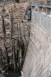
Construction on Buffalo Bill Dam, originally known as Shoshone Dam, began in 1905. Upon completion, in 1910, the dam was the highest in the world standing at 325 feet (99.1 m). The dam is a concrete arch-gravity dam
on the Shoshone River
in the U.S. state
of Wyoming
. It dam was part of the Shoshone Project
, one of the first projects overseen by the Bureau of Reclamation.
 In addition to providing water for irrigation and downstream flood control, Buffalo Bill Dam provides hydropower
for a power plant. The first and second units of the power plant were constructed in 1922. A third unit was built in 1931. Units one and two were decommissioned in 1980 and unit three was replaced in 1991.
The park was established in 1957 and rebuilt in 1993 after an eight year project to increase the height of the dam by 25 feet (7.6 m). The original park facilities were flooded when the dam was raised and the reservoir was deepened and widened. The project added 260000 acre.ft to the area of the lake. A visitors center at the dam was opened upon completion of the heightening of the dam. Further modifications to the dam included an expansion of the underground spillway
and addition of gates to the spillway for flow control.
in northwestern Wyoming. The mountainous area is part of the Absaroka Range
of the Rocky Mountains
.
The range is on the Montana
-Wyoming
border. They border the Beartooth Mountains
to the north and the Wind River Range
to the south. The mountains are named for the Absaroka
Indians. The name is derived from the Hidatsa
name for the Crow people; it means "children of the large-beaked bird."
The park, like most of the state parks in Wyoming, is a "reservoir park." This has traditionally limited recreation to the waters of the reservoirs including boating, fishing and swimming. Plans are in place to build additional hiking trails in all Wyoming state parks. The state requires that the newly built trails do not fundamentally alter the landscape of the park. Funding for the trails comes from several federal and state funds and private donations.
The picnic facilities at the park were updated in 2007 by the Wyoming Conservation Corps. The corps also built fences at the park. The picnic facilities are available to large groups with a reservation and unreserved tables and shelters are available on a first come-first served basis.
Wyoming
Wyoming is a state in the mountain region of the Western United States. The western two thirds of the state is covered mostly with the mountain ranges and rangelands in the foothills of the Eastern Rocky Mountains, while the eastern third of the state is high elevation prairie known as the High...
, United States
United States
The United States of America is a federal constitutional republic comprising fifty states and a federal district...
. The park surrounds a reservoir formed by the Buffalo Bill Dam
Buffalo Bill Dam
Buffalo Bill Dam is a concrete arch-gravity dam on the Shoshone River in the U.S. state of Wyoming. The dam is named after the famous old West figure William "Buffalo Bill" Cody who founded the nearby town of Cody and who owned much of the land now covered by the reservoir formed by the dam, which...
on the Shoshone River
Shoshone River
The Shoshone River is long river in northern Wyoming in the United States. Its headwaters are in the Absaroka Range in Shoshone National Forest. It ends when it runs into the Big Horn River near Lovell, Wyoming. Cities it runs near or through are Cody, Powell, Byron, and Lovell. Near Cody, it...
. The park, reservoir and dam were named after William "Buffalo Bill" Cody
Buffalo Bill
William Frederick "Buffalo Bill" Cody was a United States soldier, bison hunter and showman. He was born in the Iowa Territory , in LeClaire but lived several years in Canada before his family moved to the Kansas Territory. Buffalo Bill received the Medal of Honor in 1872 for service to the US...
who founded the nearby town of Cody
Cody, Wyoming
Cody is a city in Park County, Wyoming, United States. It is named after William Frederick Cody, primarily known as Buffalo Bill, from William Cody's part in the creation of the original town. The population was 9,520 at the 2010 census...
and owned much of the land now occupied by the reservoir and park. Buffalo Bill State Park is open May 1 - September 30 with limited winter access. Recreational opportunities include camping, hiking, boating, fishing and picnicking.
History
Buffalo BillBuffalo Bill
William Frederick "Buffalo Bill" Cody was a United States soldier, bison hunter and showman. He was born in the Iowa Territory , in LeClaire but lived several years in Canada before his family moved to the Kansas Territory. Buffalo Bill received the Medal of Honor in 1872 for service to the US...
, William Cody, was one of the most colorful figures of the American Old West
American Old West
The American Old West, or the Wild West, comprises the history, geography, people, lore, and cultural expression of life in the Western United States, most often referring to the latter half of the 19th century, between the American Civil War and the end of the century...
, and mostly famous for the shows he organized with cowboy
Cowboy
A cowboy is an animal herder who tends cattle on ranches in North America, traditionally on horseback, and often performs a multitude of other ranch-related tasks. The historic American cowboy of the late 19th century arose from the vaquero traditions of northern Mexico and became a figure of...
themes. He once owned some of the land that is now part of the state park bearing his name. He sold his property to the United States government prior to the construction of Buffalo Bill Dam
Buffalo Bill Dam
Buffalo Bill Dam is a concrete arch-gravity dam on the Shoshone River in the U.S. state of Wyoming. The dam is named after the famous old West figure William "Buffalo Bill" Cody who founded the nearby town of Cody and who owned much of the land now covered by the reservoir formed by the dam, which...
. Cody settled in the Shoshone Canyon area in the 1870s. He first came to the region as a guide for a survey expedition. Cody spent parts the next twenty years in the area serving as a hunting guide. Buffalo Bill worked to bring irrigation
Irrigation
Irrigation may be defined as the science of artificial application of water to the land or soil. It is used to assist in the growing of agricultural crops, maintenance of landscapes, and revegetation of disturbed soils in dry areas and during periods of inadequate rainfall...
and agriculture development in Park County. He founded the nearby city of Cody
Cody, Wyoming
Cody is a city in Park County, Wyoming, United States. It is named after William Frederick Cody, primarily known as Buffalo Bill, from William Cody's part in the creation of the original town. The population was 9,520 at the 2010 census...
in 1896.
Construction on Buffalo Bill Dam, originally known as Shoshone Dam, began in 1905. Upon completion, in 1910, the dam was the highest in the world standing at 325 feet (99.1 m). The dam is a concrete arch-gravity dam
Arch-gravity dam
An arch-gravity dam, curved-gravity dam or arched dam is a dam with the characteristics of both an arch dam and a gravity dam. It is a dam that curves upstream in a narrowing curve that directs most of the water against the canyon rock walls, providing the force to compress the dam...
on the Shoshone River
Shoshone River
The Shoshone River is long river in northern Wyoming in the United States. Its headwaters are in the Absaroka Range in Shoshone National Forest. It ends when it runs into the Big Horn River near Lovell, Wyoming. Cities it runs near or through are Cody, Powell, Byron, and Lovell. Near Cody, it...
in the U.S. state
U.S. state
A U.S. state is any one of the 50 federated states of the United States of America that share sovereignty with the federal government. Because of this shared sovereignty, an American is a citizen both of the federal entity and of his or her state of domicile. Four states use the official title of...
of Wyoming
Wyoming
Wyoming is a state in the mountain region of the Western United States. The western two thirds of the state is covered mostly with the mountain ranges and rangelands in the foothills of the Eastern Rocky Mountains, while the eastern third of the state is high elevation prairie known as the High...
. It dam was part of the Shoshone Project
Shoshone project
The Shoshone Project is an irrigation project in the U.S. state of Wyoming. The project provides irrigation for approximately of crops in the Big Horn Basin, fulfilling the vision of local resident and developer Buffalo Bill Cody, who hoped to make the semi-arid basin into agricultural land...
, one of the first projects overseen by the Bureau of Reclamation.
Hydropower
Hydropower, hydraulic power, hydrokinetic power or water power is power that is derived from the force or energy of falling water, which may be harnessed for useful purposes. Since ancient times, hydropower has been used for irrigation and the operation of various mechanical devices, such as...
for a power plant. The first and second units of the power plant were constructed in 1922. A third unit was built in 1931. Units one and two were decommissioned in 1980 and unit three was replaced in 1991.
The park was established in 1957 and rebuilt in 1993 after an eight year project to increase the height of the dam by 25 feet (7.6 m). The original park facilities were flooded when the dam was raised and the reservoir was deepened and widened. The project added 260000 acre.ft to the area of the lake. A visitors center at the dam was opened upon completion of the heightening of the dam. Further modifications to the dam included an expansion of the underground spillway
Spillway
A spillway is a structure used to provide the controlled release of flows from a dam or levee into a downstream area, typically being the river that was dammed. In the UK they may be known as overflow channels. Spillways release floods so that the water does not overtop and damage or even destroy...
and addition of gates to the spillway for flow control.
Geology
Buffalo Bill State Park is in Shoshone Canyon along the Shoshone RiverShoshone River
The Shoshone River is long river in northern Wyoming in the United States. Its headwaters are in the Absaroka Range in Shoshone National Forest. It ends when it runs into the Big Horn River near Lovell, Wyoming. Cities it runs near or through are Cody, Powell, Byron, and Lovell. Near Cody, it...
in northwestern Wyoming. The mountainous area is part of the Absaroka Range
Absaroka Range
The Absaroka Range is a sub-range of the Rocky Mountains in the United States. The range stretches about 150 mi across the Montana-Wyoming border, forming the eastern boundary of Yellowstone National Park and the western side of the Bighorn Basin. The range borders the Beartooth Mountains...
of the Rocky Mountains
Rocky Mountains
The Rocky Mountains are a major mountain range in western North America. The Rocky Mountains stretch more than from the northernmost part of British Columbia, in western Canada, to New Mexico, in the southwestern United States...
.
The range is on the Montana
Montana
Montana is a state in the Western United States. The western third of Montana contains numerous mountain ranges. Smaller, "island ranges" are found in the central third of the state, for a total of 77 named ranges of the Rocky Mountains. This geographical fact is reflected in the state's name,...
-Wyoming
Wyoming
Wyoming is a state in the mountain region of the Western United States. The western two thirds of the state is covered mostly with the mountain ranges and rangelands in the foothills of the Eastern Rocky Mountains, while the eastern third of the state is high elevation prairie known as the High...
border. They border the Beartooth Mountains
Beartooth Mountains
The Beartooth Mountains are located in south central Montana and northwest Wyoming, U.S. and are part of the 900,000 acre Absaroka-Beartooth Wilderness, within Custer, Gallatin and Shoshone National Forests. The Beartooths are the location of Granite Peak, which at 12,807 feet is the highest...
to the north and the Wind River Range
Wind River Range
The Wind River Range , is a mountain range of the Rocky Mountains in western Wyoming in the United States. The range runs roughly NW-SE for approximately 100 miles . The Continental Divide follows the crest of the range and includes Gannett Peak, which at 13,804 feet , is the highest peak...
to the south. The mountains are named for the Absaroka
Crow Nation
The Crow, also called the Absaroka or Apsáalooke, are a Siouan people of Native Americans who historically lived in the Yellowstone River valley, which extends from present-day Wyoming, through Montana and into North Dakota. They now live on a reservation south of Billings, Montana and in several...
Indians. The name is derived from the Hidatsa
Hidatsa
The Hidatsa are a Siouan people, a part of the Three Affiliated Tribes. The Hidatsa's autonym is Hiraacá. According to the tribal tradition, the word hiraacá derives from the word "willow"; however, the etymology is not transparent and the similarity to mirahací ‘willows’ inconclusive...
name for the Crow people; it means "children of the large-beaked bird."
Recreation
Buffalo Bill State Park surrounds Buffalo Bill Reservoir which is the center of recreation at the park. Recreational activities at the park include fishing, boating, hiking, camping and picnicking. The park is officially closed during the winter months, but limited recreation is available.The park, like most of the state parks in Wyoming, is a "reservoir park." This has traditionally limited recreation to the waters of the reservoirs including boating, fishing and swimming. Plans are in place to build additional hiking trails in all Wyoming state parks. The state requires that the newly built trails do not fundamentally alter the landscape of the park. Funding for the trails comes from several federal and state funds and private donations.
The picnic facilities at the park were updated in 2007 by the Wyoming Conservation Corps. The corps also built fences at the park. The picnic facilities are available to large groups with a reservation and unreserved tables and shelters are available on a first come-first served basis.