

Shoshone project
Encyclopedia
U.S. state
A U.S. state is any one of the 50 federated states of the United States of America that share sovereignty with the federal government. Because of this shared sovereignty, an American is a citizen both of the federal entity and of his or her state of domicile. Four states use the official title of...
of Wyoming
Wyoming
Wyoming is a state in the mountain region of the Western United States. The western two thirds of the state is covered mostly with the mountain ranges and rangelands in the foothills of the Eastern Rocky Mountains, while the eastern third of the state is high elevation prairie known as the High...
. The project provides irrigation for approximately 107000 acres (433 km²) of crops in the Big Horn Basin, fulfilling the vision of local resident and developer Buffalo Bill Cody, who hoped to make the semi-arid basin into agricultural land. Buffalo Bill Dam
Buffalo Bill Dam
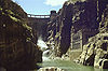
Buffalo Bill Dam is a concrete arch-gravity dam on the Shoshone River in the U.S. state of Wyoming. The dam is named after the famous old West figure William "Buffalo Bill" Cody who founded the nearby town of Cody and who owned much of the land now covered by the reservoir formed by the dam, which...
on the Shoshone River
Shoshone River
The Shoshone River is long river in northern Wyoming in the United States. Its headwaters are in the Absaroka Range in Shoshone National Forest. It ends when it runs into the Big Horn River near Lovell, Wyoming. Cities it runs near or through are Cody, Powell, Byron, and Lovell. Near Cody, it...
impounds water for the project in Buffalo Bill Reservoir. In addition to its role in irrigation, the project provides flood control on the Shoshone and generates power, using the 350 feet (106.7 m) height of Buffalo Bill Dam, once a world record, and the considerable fall of the river through Shoshone Canyon to generate hydroelectric power
Hydroelectricity
Hydroelectricity is the term referring to electricity generated by hydropower; the production of electrical power through the use of the gravitational force of falling or flowing water. It is the most widely used form of renewable energy...
. Chief crops in the Big Horn Basin are sugar beet
Sugar beet
Sugar beet, a cultivated plant of Beta vulgaris, is a plant whose tuber contains a high concentration of sucrose. It is grown commercially for sugar production. Sugar beets and other B...
s, alfalfa
Alfalfa
Alfalfa is a flowering plant in the pea family Fabaceae cultivated as an important forage crop in the US, Canada, Argentina, France, Australia, the Middle East, South Africa, and many other countries. It is known as lucerne in the UK, France, Australia, South Africa and New Zealand, and known as...
, barley
Barley
Barley is a major cereal grain, a member of the grass family. It serves as a major animal fodder, as a base malt for beer and certain distilled beverages, and as a component of various health foods...
, oats
OATS
OATS - Open Source Assistive Technology Software - is a source code repository or "forge" for assistive technology software. It was launched in 2006 with the goal to provide a one-stop “shop” for end users, clinicians and open-source developers to promote and develop open source assistive...
, corn and beans.
Establishment
At the end of the 19th century Buffalo Bill Cody settled in his namesake town of Cody, WyomingCody, Wyoming
Cody is a city in Park County, Wyoming, United States. It is named after William Frederick Cody, primarily known as Buffalo Bill, from William Cody's part in the creation of the original town. The population was 9,520 at the 2010 census...
, buying much of the surrounding lands. Cody promoted a plan to use the waters of the Shoshone to irrigate the plains of the Bighorn Basin
Bighorn Basin
The Bighorn Basin is a plateau region and intermontane basin, approximately 100 miles wide, in north-central Wyoming in the United States. It is bounded by the Absaroka Range on the west, the Bighorn Mountains on the east, and the Owl Creek Mountains and Bridger Mountains on the south...
extending eastward from Cody. Franklin Wheeler Mondell
Franklin Wheeler Mondell
Frank Wheeler Mondell was a representative of Wyoming born in St. Louis, Missouri, and educated in the public schools. For many years he was engaged in farming, stock-raising, and railroad construction. He lived in Wyoming from 1887 onward, and served in Congress from 1895 to 1897 and then from...
, later U.S. Senator from Wyoming, filed for the first water rights in 1893 but was unable to follow up on his project. Cody and his partner Nate Salisbury obtained a permit to irrigate 120000 acres (48,562.3 ha) using three canals, but were in turn unable to construct the necessary infrastructure. Cody and local promoters again obtained water rights to irrigate 60000 acres (24,281.2 ha) from the state of Wyoming in 1899 and attempted to build a private canal, but lacked sufficient resources. Following the passage of the Reclamation Act in 1902 the state urged the Department of Interior to take over the project. The federal government-backed Shoshone Project was authorized in 1904 by Secretary of the Interior Ethan Allen Hitchcock, based on the 1899 Cody-Salisbury permit. The project started the same year, administered by the Bureau of Reclamation. Work on Buffalo Bill Dam started in 1905. The small Ralston and Corbett dams were completed in 1908. Buffalo Bill Dam (known as Shoshone Dam until 1946) was completed in 1910 at a cost of $1.4 million, at a height of 325 feet (99.1 m), then the tallest dam in the world. The dam's height was extended by another 25 feet (7.6 m) to 350 feet (106.7 m) in the 1990s, significantly expanding reservoir capacity.
Land was opened for settlement near Powell
Powell, Wyoming
Powell is a city in Park County, Wyoming, United States. The population was 5,373 at the 2000 census. Powell is an All-America City and home to Northwest College.-Geography:Powell is located at ....
in the Garland Division, with extensive agricultural development by 1918. The Frannie Division was opened at about this time. The Willwood Division was opened to development between 1927 and 1938, while the Heart Mountain Division was not opened until 1947.
Administration
The project is administered in four divisions:- The Garland Division, with 35863 acres (14,513.3 ha) of irrigated land, receives water diverted into the Garland Canal by the Corbett Diversion Dam on the Shoshone, 16 miles (25.7 km) downstream from Buffalo Bill Dam. The 18 miles (29 km) canal has a capacity of 1000 cuft/s. The Garland Division is administered by the Shoshone Irrigation District, directed by local water users.
- The Heart Mountain Division, with 31120 acres (12,593.8 ha) receives seasonal output from the Heart Mountain Powerplant, which discharges into an inverted siphonSiphonThe word siphon is sometimes used to refer to a wide variety of devices that involve the flow of liquids through tubes. But in the English language today, the word siphon usually refers to a tube in an inverted U shape which causes a liquid to flow uphill, above the surface of the reservoir,...
crossing the Shoshone River. The 26 miles (41.8 km) Heart Mountain Canal transports the water to users at a rate of 915 cuft/s. Portions of the Heart Mountain Canal were built with labor provided by the Civilian Conservation CorpsCivilian Conservation CorpsThe Civilian Conservation Corps was a public work relief program that operated from 1933 to 1942 in the United States for unemployed, unmarried men from relief families, ages 18–25. A part of the New Deal of President Franklin D...
from camp BR-72. Japanese American internees from the Heart Mountain Relocation Center worked on the canal in from 1942 until May 1944. Work was finally completed in 1947. - The Frannie Division, with 14600 acres (5,908.4 ha) receives water from the Garland Canal through a branch canal, the Frannie Canal, which is 44 miles (70.8 km) long and carries 550 cuft/s.
- The Willwood Division, with 11530 acres (4,666 ha) receives water from the Willwood Diversion dam on the Shoshone, 8 miles (12.9 km) downstream from the Corbett Diversion Dam. The Willwood Canal extends for 28 miles (45.1 km) and can deliver water at 320 cuft/s.
Power generation
Waters impounded by Buffalo Bill Dam operate four power plants, two close to the dam's base and two others operated by water piped from the dam, taking advantage of the height change through Shoshone Canyon to place the power stations in the flats beyond the mountain canyon. The original powerplant, the Shoshone Powerplant, and what was initially intended to be a temporary Heart Mountain Powerplant, were supplemented and upgraded with the dam's increase in height from 1992-1994.- Shoshone Powerplant: Originally built in 1922, the Shoshone Powerplant is located in Shoshone Canyon 600 feet (182.9 m) from the base of the dam, and operated until 1980. Units 1 and 2 came on line in 1922, Unit 3 in 1931. Installed capacty was 6.012 MW. All three units were shut down in 1980, worn out from fifty years of service. 1 and 2 were decommissioned and left in place, while 3 was replaced with a new 3 MW Francis turbineFrancis turbineThe Francis turbine is a type of water turbine that was developed by James B. Francis in Lowell, Massachusetts. It is an inward-flow reaction turbine that combines radial and axial flow concepts....
unit that started operation in 1992. The plant operates with a head of 220 feet (67.1 m). - Buffalo Bill Powerplant: The Buffalo Bill Powerplant was built concurrently with work to increase the dam's height by 25 feet (7.6 m) in 1992. The plant, located in Shoshone Canyon downstream from the original Shoshone Powerplant, operates a Francis turbine rated at 18 MW on a head of 266 feet (81.1 m).
- Heart Mountain Powerplant: Located at the outlet of the Shoshone Canyon Conduit, the Heart Mountain Powerplant was built in 1947 as a temporary facility. It was rebuilt concurrently with the dam heightening project and is operated on a seasonal basis. It operates a 5 MW Francis turbine on a 265 feet (80.8 m) head. Located near a geothermally active areaColter's HellColter's Hell is an area of fumaroles and hot springs on the Shoshone River near Cody in the US state of Wyoming. The thermal area covers about a square mile at the mouth of the Shoshone's canyon. Its thermal activity has declined ever since its description by mountain man John Colter, who passed...
, construction of the tunnel proved difficult, with fumes contributing to the deaths of two construction workers in 1937. - Spirit Mountain Powerplant: The Spirit Mountain Powerplant receives pressurized water through a conduit. It primarily functions to dissipate the pressure in the conduit before it enters an open canal, generating power as a byproduct. The unit operates a Francis turbine generating 4.5 MW on a seasonal base load basis, with a 110 feet (33.5 m) head. It was built in 1994.
External links
- Shoshone Project at the Bureau of Reclamation
- Shoshone Project History at the Bureau of Reclamation
- Shoshone Irrigation District, focusing on the area around Powell, Wyoming