
Buckhannon River
Encyclopedia
The Buckhannon River is a 45.4 miles (73.1 km) tributary
of the Tygart Valley River
in north-central West Virginia
, USA. Via the Tygart Valley, Monongahela
and Ohio
rivers, it is part of the watershed
of the Mississippi River
, draining an area of 309 square miles (800.3 km²) on the unglaciated portion of the Allegheny Plateau
. It provides drinking water for much of Upshur County
.
by the confluence of the Left Fork Buckhannon River and the Right Fork Buckhannon River, both of which rise in southwestern Randolph County
at elevations of 3658 feet (1,115 m) and 3401 feet (1,036.6 m), respectively, and flow generally north-northwestwardly into southern Upshur County. The Right Fork flows through the communities of Pickens
and Selbyville
and collects tributaries known as the Middle Fork Right Fork Buckhannon River and the Left Fork Right Fork Buckhannon River; the Left Fork of the Right Fork flows through the community of Helvetia
.
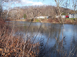
From Alexander the Buckhannon River flows generally northwardly, past Sago
, to the city of Buckhannon
, then northeastwardly into southwestern Barbour County
, past Boulder (Rangoon Post Office) and Carrollton
, where it is crossed by the Carrollton Covered Bridge
. It joins the Tygart Valley River just downstream of Carrollton, approximately 4 miles (6 km) southwest of Philippi
.
 According to the West Virginia Department of Environmental Protection, approximately 79.5% of the Buckhannon River's watershed is forest
ed, mostly deciduous
; approximately 18.1% is used for agriculture
and pasture
; and less than 1% is urban.
(died 1805), a Lenape
ally of the British during the Revolutionary War
. The most plausible accounts, however, indicate the river was named for clergyman John Buchannon, a missionary who explored the region in the 1780s.
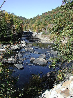
-strewn, providing habitat for trout
(particularly brown trout
), smallmouth bass
, and rock bass
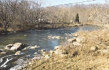
. A low dam, installed for the provision of drinking water, forms a pool stretching upstream of Buckhannon to Sago; downstream of Sago, the Buckhannon is considered to be one of the best streams for muskellunge
fishing in West Virginia. For 20 miles (32.2 km) downstream of Buckhannon, the river generally moves slowly between vegetation-covered banks over numerous submerged logs, providing habitat for muskies as well as smallmouth bass, rock bass, and carp
. In its lowermost course above its mouth, the river assumes a higher gradient and is home to smallmouth bass, rock bass, and sunfish
.
 According to the Geographic Names Information System
, the Buckhannon River has also been known as:
Tributary
A tributary or affluent is a stream or river that flows into a main stem river or a lake. A tributary does not flow directly into a sea or ocean...
of the Tygart Valley River
Tygart Valley River
The Tygart Valley River — also known as the Tygart River — is a principal tributary of the Monongahela River, approximately long, in east-central West Virginia, USA...
in north-central West Virginia
West Virginia
West Virginia is a state in the Appalachian and Southeastern regions of the United States, bordered by Virginia to the southeast, Kentucky to the southwest, Ohio to the northwest, Pennsylvania to the northeast and Maryland to the east...
, USA. Via the Tygart Valley, Monongahela
Monongahela River
The Monongahela River is a river on the Allegheny Plateau in north-central West Virginia and southwestern Pennsylvania in the United States...
and Ohio
Ohio River
The Ohio River is the largest tributary, by volume, of the Mississippi River. At the confluence, the Ohio is even bigger than the Mississippi and, thus, is hydrologically the main stream of the whole river system, including the Allegheny River further upstream...
rivers, it is part of the watershed
Drainage basin
A drainage basin is an extent or an area of land where surface water from rain and melting snow or ice converges to a single point, usually the exit of the basin, where the waters join another waterbody, such as a river, lake, reservoir, estuary, wetland, sea, or ocean...
of the Mississippi River
Mississippi River
The Mississippi River is the largest river system in North America. Flowing entirely in the United States, this river rises in western Minnesota and meanders slowly southwards for to the Mississippi River Delta at the Gulf of Mexico. With its many tributaries, the Mississippi's watershed drains...
, draining an area of 309 square miles (800.3 km²) on the unglaciated portion of the Allegheny Plateau
Allegheny Plateau
The Allegheny Plateau is a large dissected plateau area in western and central New York, northern and western Pennsylvania, northern and western West Virginia, and eastern Ohio...
. It provides drinking water for much of Upshur County
Upshur County, West Virginia
As of the census of 2000, there were 23,404 people, 8,972 households, and 6,352 families residing in the county. The population density was 66 people per square mile . There were 10,751 housing units at an average density of 30 per square mile...
.
Geography
The Buckhannon River is formed at the community of Alexander in southern Upshur CountyUpshur County, West Virginia
As of the census of 2000, there were 23,404 people, 8,972 households, and 6,352 families residing in the county. The population density was 66 people per square mile . There were 10,751 housing units at an average density of 30 per square mile...
by the confluence of the Left Fork Buckhannon River and the Right Fork Buckhannon River, both of which rise in southwestern Randolph County
Randolph County, West Virginia
As of the census of 2000, there were 28,262 people, 11,072 households, and 7,661 families residing in the county. The population density was 27 people per square mile . There were 13,478 housing units at an average density of 13 per square mile...
at elevations of 3658 feet (1,115 m) and 3401 feet (1,036.6 m), respectively, and flow generally north-northwestwardly into southern Upshur County. The Right Fork flows through the communities of Pickens
Pickens, West Virginia
Pickens is an unincorporated census-designated place in Randolph County, West Virginia, United States. Pickens is west-southwest of Huttonsville. It is the home of the Cunningham-Roberts Museum. Pickens has a post office with ZIP code 26230. As of the 2010 census, its population was 66....
and Selbyville
Selbyville, West Virginia
Selbyville is an unincorporated community along the Right Fork Buckhannon River in Upshur County, West Virginia, United States.Selbyville's public schools are operated by Upshur County Schools....
and collects tributaries known as the Middle Fork Right Fork Buckhannon River and the Left Fork Right Fork Buckhannon River; the Left Fork of the Right Fork flows through the community of Helvetia
Helvetia, West Virginia
Helvetia is an unincorporated census-designated place in Randolph County, West Virginia, United States. As of the 2010 census, its population was 59...
.
From Alexander the Buckhannon River flows generally northwardly, past Sago
Sago, West Virginia
Sago is an unincorporated community in Upshur County, West Virginia. It is located along the Buckhannon River and is the site of the Sago Mine, scene of the 2006 Sago Mine disaster....
, to the city of Buckhannon
Buckhannon, West Virginia
Buckhannon is the only incorporated city in, and the county seat of, Upshur County, West Virginia, United States, and is located along the Buckhannon River. The population was 5,725 at the 2000 census. Buckhannon is home to West Virginia Wesleyan College and the West Virginia Strawberry Festival,...
, then northeastwardly into southwestern Barbour County
Barbour County, West Virginia
As of the census of 2000, there are 15,557 people, 6,123 households, and 4,365 families residing in the county. The population density is 46 people per square mile . There are 7,348 housing units at an average density of 22 per square mile...
, past Boulder (Rangoon Post Office) and Carrollton
Carrollton, West Virginia
Carrollton is an unincorporated community in Barbour County in the U.S. state of West Virginia. Carrollton is known for its Carrollton Covered Bridge over the Buckhannon River, listed on the National Register of Historic Places....
, where it is crossed by the Carrollton Covered Bridge
Carrollton Covered Bridge
The Carrollton Covered Bridge, in Barbour County, West Virginia, USA, is the second longest and third oldest surviving covered bridge in the state. The wooden bridge spans the Buckhannon River near Carrollton and was built in 1856. It underwent repairs in 1978 and was added to the National Register...
. It joins the Tygart Valley River just downstream of Carrollton, approximately 4 miles (6 km) southwest of Philippi
Philippi, West Virginia
Philippi is a city in — and the county seat of — Barbour County, West Virginia, USA. The population was 2,870 at the 2000 census. In 1861, the city was the site of the Battle of Philippi, known as "The Philippi Races"...
.
Forest
A forest, also referred to as a wood or the woods, is an area with a high density of trees. As with cities, depending where you are in the world, what is considered a forest may vary significantly in size and have various classification according to how and what of the forest is composed...
ed, mostly deciduous
Deciduous
Deciduous means "falling off at maturity" or "tending to fall off", and is typically used in reference to trees or shrubs that lose their leaves seasonally, and to the shedding of other plant structures such as petals after flowering or fruit when ripe...
; approximately 18.1% is used for agriculture
Agriculture
Agriculture is the cultivation of animals, plants, fungi and other life forms for food, fiber, and other products used to sustain life. Agriculture was the key implement in the rise of sedentary human civilization, whereby farming of domesticated species created food surpluses that nurtured the...
and pasture
Pasture
Pasture is land used for grazing. Pasture lands in the narrow sense are enclosed tracts of farmland, grazed by domesticated livestock, such as horses, cattle, sheep or swine. The vegetation of tended pasture, forage, consists mainly of grasses, with an interspersion of legumes and other forbs...
; and less than 1% is urban.
Name
Local lore holds that the Buckhannon was named for BuckongahelasBuckongahelas
Buckongahelas was a regionally and nationally renowned Lenape chief, councilor and warrior. He was active from the days of the French and Indian War through the Northwest Indian Wars, after the United States achieved independence and settlers encroached on territory beyond the Appalachian...
(died 1805), a Lenape
Lenape
The Lenape are an Algonquian group of Native Americans of the Northeastern Woodlands. They are also called Delaware Indians. As a result of the American Revolutionary War and later Indian removals from the eastern United States, today the main groups live in Canada, where they are enrolled in the...
ally of the British during the Revolutionary War
American Revolutionary War
The American Revolutionary War , the American War of Independence, or simply the Revolutionary War, began as a war between the Kingdom of Great Britain and thirteen British colonies in North America, and ended in a global war between several European great powers.The war was the result of the...
. The most plausible accounts, however, indicate the river was named for clergyman John Buchannon, a missionary who explored the region in the 1780s.
Fish life
The uppermost (southernmost) stretch of the river downstream of Alexander drops approximately 400 feet (121.9 m) in its first 13 miles (20.9 km) and is boulderBoulder
In geology, a boulder is a rock with grain size of usually no less than 256 mm diameter. While a boulder may be small enough to move or roll manually, others are extremely massive....
-strewn, providing habitat for trout
Trout
Trout is the name for a number of species of freshwater and saltwater fish belonging to the Salmoninae subfamily of the family Salmonidae. Salmon belong to the same family as trout. Most salmon species spend almost all their lives in salt water...
(particularly brown trout
Brown trout
The brown trout and the sea trout are fish of the same species....
), smallmouth bass
Smallmouth bass
The smallmouth bass is a species of freshwater fish in the sunfish family of the order Perciformes. It is the type species of its genus...
, and rock bass
Rock bass
The rock bass , also known as the rock perch, goggle-eye, or red eye is a species of freshwater fish in the sunfish family of order Perciformes. They are similar in appearance to smallmouth bass but are usually quite a bit smaller...
. A low dam, installed for the provision of drinking water, forms a pool stretching upstream of Buckhannon to Sago; downstream of Sago, the Buckhannon is considered to be one of the best streams for muskellunge
Muskellunge
A muskellunge , also known as a muskelunge, muscallonge, milliganong, or maskinonge , is a large, relatively uncommon freshwater fish of North America. Muskellunge are the largest member of the pike family, Esocidae...
fishing in West Virginia. For 20 miles (32.2 km) downstream of Buckhannon, the river generally moves slowly between vegetation-covered banks over numerous submerged logs, providing habitat for muskies as well as smallmouth bass, rock bass, and carp
Carp
Carp are various species of oily freshwater fish of the family Cyprinidae, a very large group of fish native to Europe and Asia. The cypriniformes are traditionally grouped with the Characiformes, Siluriformes and Gymnotiformes to create the superorder Ostariophysi, since these groups have certain...
. In its lowermost course above its mouth, the river assumes a higher gradient and is home to smallmouth bass, rock bass, and sunfish
Centrarchidae
The sunfishes are a family of freshwater ray-finned fish belonging to the order Perciformes. The type genus is Centrarchus . The family's 27 species includes many fishes familiar to North Americans, including the rock bass, largemouth bass, bluegill, pumpkinseed, and crappies...
.
Variant names and spellings
Geographic Names Information System
The Geographic Names Information System is a database that contains name and locative information about more than two million physical and cultural features located throughout the United States of America and its territories. It is a type of gazetteer...
, the Buckhannon River has also been known as:
- Buchanan River
- Buchanon River
- Buckanan River
- Buckhanan River
- Buckhannans Fork
- Buckhanon River