

Brisbane Ferries
Encyclopedia
Queensland
Queensland is a state of Australia, occupying the north-eastern section of the mainland continent. It is bordered by the Northern Territory, South Australia and New South Wales to the west, south-west and south respectively. To the east, Queensland is bordered by the Coral Sea and Pacific Ocean...
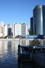
. The first ferry started on at Russell Street with a service across the Brisbane River
Brisbane River
The Brisbane River is the longest river in south east Queensland, Australia, and flows through the city of Brisbane, before emptying into Moreton Bay. John Oxley was the first European to explore the river who named it after the Governor of New South Wales, Thomas Brisbane in 1823...
.
Crossings in the Brisbane central business district and at Bulimba, Dutton Park, Indooroopilly and Moggill were needed for road transport to develop in growing town. Before the Story Bridge and Sir Leo Hielscher Bridges were constructed ferries transported vehicles across the river at these locations. Some of the more significant services vital to various communities, include the Daintree River Ferry, services to Thursday Island, Magnetic Island, Fraser Island, North Stradbroke Island and other islands in Moreton Bay.
Ferry services in Queensland are regulated by the Department of Transport and Main Roads. Services in Brisbane, including the CityCat are operated by TransdevTSL under a contract with Brisbane City Council.
Department of Transport & Main Roads
The Department of Transport and Main RoadsDepartment of Transport and Main Roads
The Department of Transport and Main Roads is a department of the Queensland Government. The department manages Queensland's approximately 33,000 km state-controlled road network, which includes more than 6,500 bridges and major culverts...
(TMR) is the entity responsible for overseeing ferry
Ferry
A ferry is a form of transportation, usually a boat, but sometimes a ship, used to carry primarily passengers, and sometimes vehicles and cargo as well, across a body of water. Most ferries operate on regular, frequent, return services...
services in Queensland
Queensland
Queensland is a state of Australia, occupying the north-eastern section of the mainland continent. It is bordered by the Northern Territory, South Australia and New South Wales to the west, south-west and south respectively. To the east, Queensland is bordered by the Coral Sea and Pacific Ocean...
. The TMR contracts with ferry operators and is responsible for the provision of services between: Palm Island
Palm Island, Queensland
Palm Island is an Aboriginal community located on Great Palm Island, also called by the Aboriginal name "Bwgcolman", an island on the Great Barrier Reef in North Queensland, Australia The settlement is also known by a variety of other names including "the Mission", Palm Island Settlement or Palm...
and Townsville, Magnetic Island
Magnetic Island
Magnetic Island is an island offshore from the city of Townsville, Queensland, Australia. This mountainous island in Cleveland Bay has effectively become a suburb of Townsville, with 2,107 permanent residents. The island is accessible from Townsville Breakwater to Nelly Bay Harbour by ferry...
and Townsville, Seisia and Thursday Island, Coochiemudlo Island
Coochiemudlo Island, Queensland
Coochiemudlo Island is located near Brisbane, in Queensland, Australia.Coochiemudlo Island is a small island in the southern part of Moreton Bay, Queensland.The island is approximately 1 km from Victoria Point in Redland Shire....
and Victoria Point
Victoria Point, Queensland
Victoria Point is a suburb located approximately south-east of Brisbane, the capital city of Queensland, Australia, in the Redland City local government area...
, North Stradbroke Island
North Stradbroke Island
North Stradbroke Island is an Australian island in the state of Queensland, 30 km southeast of the capital Brisbane. Before 1896 the island was part of the Stradbroke Island. In that year a storm separated it from South Stradbroke Island, forming the Jumpinpin Channel. It is known...
and Toondah Harbour, Cleveland
Cleveland, Queensland
Cleveland is a suburb located approximately east-south-east of Brisbane, the capital of the Australian state of Queensland, and is the council seat for the Redland City local government area...
, and between Redland Bay and the Southern Moreton Bay Islands.
Brisbane City Council has contracted TransdevTSL Brisbane Ferries to operate on the Brisbane River
Brisbane River
The Brisbane River is the longest river in south east Queensland, Australia, and flows through the city of Brisbane, before emptying into Moreton Bay. John Oxley was the first European to explore the river who named it after the Governor of New South Wales, Thomas Brisbane in 1823...
.
Queensland Passenger Transport Legislation
The legislative framework that enables the Queensland Department of Transport and Main RoadsDepartment of Transport and Main Roads
The Department of Transport and Main Roads is a department of the Queensland Government. The department manages Queensland's approximately 33,000 km state-controlled road network, which includes more than 6,500 bridges and major culverts...
(TMR) to administer the state-wide transport system that includes the ferry services is the Transport Operations (Passenger Transport) Act 1994 (the act), Transport Operations (Passenger Transport) Regulation 2005 (the regulation) and Transport Operations (Passenger Transport) Standard 2010 (the standard). The TMR employ terms that are contained within the Transport Operations (Passenger Transport) Act 1994: a Ferry
Ferry
A ferry is a form of transportation, usually a boat, but sometimes a ship, used to carry primarily passengers, and sometimes vehicles and cargo as well, across a body of water. Most ferries operate on regular, frequent, return services...
can be a ship
Ship
Since the end of the age of sail a ship has been any large buoyant marine vessel. Ships are generally distinguished from boats based on size and cargo or passenger capacity. Ships are used on lakes, seas, and rivers for a variety of activities, such as the transport of people or goods, fishing,...
, boat
Boat
A boat is a watercraft of any size designed to float or plane, to provide passage across water. Usually this water will be inland or in protected coastal areas. However, boats such as the whaleboat were designed to be operated from a ship in an offshore environment. In naval terms, a boat is a...
, barge
Barge
A barge is a flat-bottomed boat, built mainly for river and canal transport of heavy goods. Some barges are not self-propelled and need to be towed by tugboats or pushed by towboats...
or hovercraft
Hovercraft
A hovercraft is a craft capable of traveling over surfaces while supported by a cushion of slow moving, high-pressure air which is ejected against the surface below and contained within a "skirt." Although supported by air, a hovercraft is not considered an aircraft.Hovercraft are used throughout...
; a Public Passenger Vehicle
Public transport
Public transport is a shared passenger transportation service which is available for use by the general public, as distinct from modes such as taxicab, car pooling or hired buses which are not shared by strangers without private arrangement.Public transport modes include buses, trolleybuses, trams...
is a vehicle used to transport members of the public and a Scheduled Passenger Service is a service —
-
- (a) conducted on a route in accordance with a timetable for the service; or
- (b) conducted on a route that forms a circle or loop (commonly called a ‘loop service’); or
- (c) conducted on a continuous basis between 2 points (commonly called a ‘shuttle service’); or
- (d) under which the vehicle used may, at the request of individual passengers, deviate from the usual route from time to time (commonly called a ‘route deviation service’); or
- (e) under which the actual route to be traversed may vary within a corridor or zone at the request of individual passengers each time the service operates (commonly called a ‘dial and ride service’).
TMR Regions
The TMR is divided into the following administrative regions which, where content is available, form the basis of the remaining information:Central West, Darling Downs, Far North
Far North Queensland
Far North Queensland, or FNQ, is the northernmost part of the Australian state of Queensland. The region, which contains a large section of the Tropical North Queensland area, stretches from the city of Cairns north to the Torres Strait...
, Fitzroy, Mackay/Whitsunday, Metropolitan, North Coast, North West, Northern
North Queensland
North Queensland or the Northern Region is the northern part of the state of Queensland in Australia. Queensland is a massive state, larger than most countries, and the tropical northern part of it has been historically remote and undeveloped, resulting in a distinctive regional character and...
, South Coast, South West and Wide Bay-Burnett
Wide Bay-Burnett
Wide Bay-Burnett is a region of the Australian state of Queensland, located between 170 and 400 kilometres north of the state capital, Brisbane. The area's population growth has exceeded the state average over the past 20 years, and it is forecast to grow to more than 430,000 by 2031...
.
TMR Regions Map
Far North
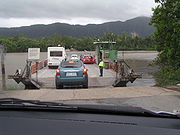
Daintree River Ferry
The Daintree River Ferry is a cable ferry across the Daintree River in Queensland, Australia. The ferry is situated some north of Port Douglas, and gives access to the northern section of the Daintree National Park and to Cape Tribulation...
is a cable ferry
Cable ferry
A cable ferry is guided and in many cases propelled across a river or other larger body of water by cables connected to both shores. They are also called chain ferries, floating bridges, or punts....
across the Daintree River
Daintree River
The Daintree River runs through the Daintree Rainforest in the Cape Tribulation region of Queensland in northern Australia. It is located about 100 kilometres northwest of Cairns in far north tropical Queensland and drains an area of 2,125 square kilometres. The river, along with the Daintree...
in Cape Tribulation
Cape Tribulation
Cape Tribulation is a headland and locality in northern Queensland, Australia north of Cairns. It is located within the Daintree National Park and the Wet Tropics World Heritage area. At the 2006 census, Cape Tribulation had a population of 101....
. The ferry is the only cable ferry operating within tropical Australia and its daily hours of operation are between 6am and midnight. In July 2003, the Shire of Douglas
Shire of Douglas
The Shire of Douglas was a Local Government Area in Far North Queensland. It was located on the coast north of the city of Cairns. The shire, administered from the town of Mossman, covered an area of , and existed as a local government entity from 1880 until 2008, when it amalgamated with the City...
overturned a motion to investigate the construction of a low-lying single lane bridge with a boom gate and a second ferry across the Daintree. Residents feared a bridge would threatened the rainforest due to a potential increase in traffic. Where as tourist operators stated a bridge would have boosted the local economy. Over the 2011 Easter
Easter
Easter is the central feast in the Christian liturgical year. According to the Canonical gospels, Jesus rose from the dead on the third day after his crucifixion. His resurrection is celebrated on Easter Day or Easter Sunday...
long weekend, during a period when the ferry was free, tourists using the ferry dramatically increased and resorts were booked out. After Easter local tourism operators expressed a desire for the ferry to be free year-round but their suggestion was ignored. As of 1 July 2011, the cost of a return ticket for private use motor cars & utilities was $22.00. Limited annual quantities of Daintree ferry concessional travel policy applies to the following people: Cairns Regional Council
Cairns Regional Council
The Cairns Region is a Local Government Area in Far North Queensland, Queensland, Australia, centred on the regional centre of Cairns. Established in 2008, it was preceded by two previous local government areas which dated back to the 1870s....
ratepayers, residents, business operators and employees who work north of the Daintree River and are within the former Douglas Shire area; Queensland Health
Queensland Health
Queensland Health is the department of the Government of Queensland responsible for operating and administering the public health system of the Australian State of Queensland. It is responsible to the State's Health Minister Geoff Wilson and its Director-General is Tony O'Connell.Queensland Health...
or Blue Care who travel across the Daintree Ferry in the course of their duties; and Residents of the Wujal Wujal Aboriginal Shire and some Cook Shire Council residents.
Torres Strait
Torres Strait
The Torres Strait is a body of water which lies between Australia and the Melanesian island of New Guinea. It is approximately wide at its narrowest extent. To the south is Cape York Peninsula, the northernmost continental extremity of the Australian state of Queensland...
ferry services are focused on Thursday Island. Peddell's Ferry has a service from Seisia
Seisia, Queensland
Seisia is an area north of New Mapoon and west of Bamaga at the tip of Cape York Peninsula in Queensland, Australia. At the 2006 census, Seisia had a population of 165....
to Thursday Island. Torres Strait Tours and McDonald Charter Boats both operate ferry services between Thursday Island and Horn Island.
From Cairns, Fitzroy Island, 25 km offshore from Cairns, can be reached by Sunkist Ferry Services, Raging Thunder Ferry Services and Sunlover Ferry Services and Green Island National Park
Green Island National Park
Green Island National Park is a protected area declared over a small coral cay known to the local Gungganyji Aboriginal peoples as Dabuukji...
, 27 km offshore from Cairns, can be reached by Big Cat Green Island Reef Cruises.
Fitzroy
Curtis Ferry Services provide a passenger ferry from GladstoneGladstone, Queensland
- Education :Gladstone has several primary schools, three high schools, and one university campus, Central Queensland University. It is also home to CQIT Gladstone Campus.- Recreation :...
Marina to Curtis Island
Curtis Island National Park
Curtis Island is an island that contains Curtis Island National Park. It is in Queensland, Australia, 474 km northwest of Brisbane and 40 kilometres southeast of Rockhampton....
and Facing Island.
Brisbane River
A brief description of former passenger and vehicular ferries that serviced the Brisbane RiverBrisbane River
The Brisbane River is the longest river in south east Queensland, Australia, and flows through the city of Brisbane, before emptying into Moreton Bay. John Oxley was the first European to explore the river who named it after the Governor of New South Wales, Thomas Brisbane in 1823...
is provided. Proceeded by details of current operational services and networks.
History & Former Ferries
In 1838, Brisbane
Brisbane
Brisbane is the capital and most populous city in the Australian state of Queensland and the third most populous city in Australia. Brisbane's metropolitan area has a population of over 2 million, and the South East Queensland urban conurbation, centred around Brisbane, encompasses a population of...
was opened up to free settlers, one of the biggest obstacle to its expansion at the time was the Brisbane River. In February 1842, the first real wave of settlers up the river followed the proclamation of the free settlement of Moreton Bay District. Only a fitful rowboat ferry connected North Brisbane to the more industrial settlement of Kangaroo Pt, and another to South Brisbane, which became known particularly for its wayfaring inns. Early settlers crossing the river by row boats often had their horse swimming behind.
In 1844, a service started operating between Customs House
Customs House, Brisbane
Customs House is a building located on Queen Street by the Brisbane River in Brisbane, Queensland, Australia. It was originally used for the collection of customs duty and was both completed and opened in 1889, when Queensland was a British colony, replacing the original Customs House located at...
and Kangaroo Point
Kangaroo Point, Queensland
Kangaroo Point is a suburb of Brisbane, Queensland, Australia located directly east across the Brisbane River from the Brisbane central business district.- Geography :...
.
By the 1860s, services operated from Brisbane to Kangaroo Point
Kangaroo Point, Queensland
Kangaroo Point is a suburb of Brisbane, Queensland, Australia located directly east across the Brisbane River from the Brisbane central business district.- Geography :...
, Alice Street
Alice Street, Brisbane
Alice Street is a central road in Brisbane, Australia. It is the most southern major road in the city's central business district, running parallel to the other female named streets in the city....
to Naval Stores and Charlotte Street
Charlotte Street, Brisbane
Charlotte Street is a road in the central business district of Brisbane. The street is one of a number that were named after female queens and princesses of the royal family shortly after the penal colony was settled...
to Russell Street, Brisbane.
Around 1883, the first steam ferry commenced operation between Charlotte Street and Kangaroo Point.
The early ferry services were privately run until Brisbane City Council created by-laws in 1860 governing their operation. By 1893 the Council had taken control of all ferry services and leased them out to private operators. In 1925, with the merger of all the local Brisbane councils into the Brisbane City Council, all ferry services from the Moggill Ferry to the mouth of the river came under its control.
Samuel and Matthew Buckley began a row boat service in 1850. Later in 1864 John Watson commenced a vehicular ferry service with the steam paddleboat Advance. The 1893 Brisbane flood
1893 Brisbane flood
The 1893 Brisbane flood, occasionally referred to as the Great Flood of 1893 or the Black February flood, occurred when the Brisbane River burst its banks on three occasions in February 1893. It is the occurrence of three major floods in the same month that saw the period named "Black February"....
saw this transferred to the city with the loss of the Victoria Bridge
Victoria Bridge, Brisbane
The Victoria Bridge is a vehicular and pedestrian bridge over the Brisbane River. The current bridge, opened in 1969, is the third permanent crossing erected at this location...
, a winch and cable punt continued in its place. 1928 saw the steam ferry Hetherington enter service and it carried passengers and vehicles, between Bulimba and Teneriffe until its demise in 1952. Bulimba village was served by a vehicular steam ferry (1886), connecting with the Newstead horse-tram service (1888) which was electrified during the late 1890s. A walk down Oxford Street to the ferry remained the sole means of convenient public transport to Brisbane until the 1930s.
The Dutton Park Ferry was operational between the University of Queensland
University of Queensland
The University of Queensland, also known as UQ, is a public university located in state of Queensland, Australia. Founded in 1909, it is the oldest and largest university in Queensland and the fifth oldest in the nation...
, St Lucia
St Lucia, Queensland
St Lucia is an inner suburb of Brisbane, Australia located 4 km south-west of the Brisbane CBD. The suburb is bordered on three sides by the Brisbane River and is dominated by the main campus of the University of Queensland.-History:...
and Dutton Park
Dutton Park, Queensland
Dutton Park is a suburb of Brisbane, Australia located 5 km south of the Brisbane CBD. The suburb is predominantly residential, with some light industrial and commercial areas....
. As a prank
Practical joke
A practical joke is a mischievous trick played on someone, typically causing the victim to experience embarrassment, indignity, or discomfort. Practical jokes differ from confidence tricks in that the victim finds out, or is let in on the joke, rather than being fooled into handing over money or...
, the University of Queensland's Student Union created a petition with approximately 4000 signatures, largely gathered from the Regatta Hotel, and convinced Lord Mayor Clem Jones
Clem Jones
Clem Jones AO a surveyor by profession, was the longest serving Lord Mayor of the city of Brisbane, Australia, representing the Australian Labor Party from 1961 to 1975.-Public life:...
of the need for the ferry service. Upon completion of the Pamela Sue ferry the service began in March 1967. Six months after it commenced the number of passengers was well short of expectations. In 1967, the fare was 5 cents, the service had limited running hours and catered for 300 passengers a day. At its highpoint the service had two boats, a fare of $1.40, four captains, serviced 1900 passengers per day and running hours from 6.30am until 9.55pm, five days a week. Over the years 3 boats serviced the crossing. The 1974 Brisbane Flood
1974 Brisbane flood
The 1974 Brisbane flood occurred in January 1974 in Brisbane, Queensland, Australia, when waterways in the city experienced significant flooding...
washed away landings and destroyed ferries. The Dutton Park crossing was Brisbane's only wholly privately run ferry service. Its closure occurred on the 17th of December, 2006, when the new Eleanor Schonell Bridge
Eleanor Schonell Bridge
The Eleanor Schonell Bridge, better known as the Green Bridge, is a 390-metre -long cable-stayed bridge which crosses the Brisbane River between Dutton Park and the University of Queensland's St Lucia campus. Its deck is 185 metres long, 20 metres wide and about 18 metres above the river's surface...
opened.
Travellers between Ipswich
Ipswich, Queensland
Ipswich is a city in South-East Queensland, Australia. Situated along the Bremer River Valley approximately 40 kilometres away from the state's capital Brisbane. The suburb by the same name forms the city's Central Business District and administrative centre...
and Brisbane
Brisbane
Brisbane is the capital and most populous city in the Australian state of Queensland and the third most populous city in Australia. Brisbane's metropolitan area has a population of over 2 million, and the South East Queensland urban conurbation, centred around Brisbane, encompasses a population of...
, prior to the opening of the Indooroopilly rail bridge
Albert Bridge, Brisbane
The Albert Bridge is a railway bridge of steel truss design crossing the Brisbane River, Queensland, Australia. The Albert Bridge links Indooroopilly and Chelmer stations, and has two long spans with one central pier....
in 1876, would travel by train to Riverton as Sherwood
Sherwood, Queensland
Sherwood is a suburb of Brisbane, Australia. It is 9 km south west of the CBD and borders the Brisbane River. The suburb is mostly low and medium density housing with a retail strip centered along Sherwood Road.-Open Space:...
was then known, catch the ferry across the river then finish their journey by coach. On the 11 June 1891 the ferry service was interrupted as a result of floodwaters. Increasing motor traffic meant the Indooroopilly ferry was perceived as overtaxed and Local associations and bodies as far away as Ipswich
Ipswich, Queensland
Ipswich is a city in South-East Queensland, Australia. Situated along the Bremer River Valley approximately 40 kilometres away from the state's capital Brisbane. The suburb by the same name forms the city's Central Business District and administrative centre...
formed a bridge league, headed by the president of the Graceville progress association, Walter Taylor. They wanted the Chelmer-Indooroopilly ferry service replaced by a road bridge and they won their battle, the ferry continued to operate until the opening of the Walter Taylor Bridge on 14 February 1936.
At Queensport Road, Murarrie
Murarrie, Queensland
Murarrie is a suburb of Brisbane, Australia. It is located in the eastern suburbs on the southern bank of the Brisbane River adjacent to the Gateway Bridge.Murarrie has both residential and industrial sections...
was a vehicular ferry named the "James Holt" that was launched in 1966 by the Lord Mayor Clem Jones
Clem Jones
Clem Jones AO a surveyor by profession, was the longest serving Lord Mayor of the city of Brisbane, Australia, representing the Australian Labor Party from 1961 to 1975.-Public life:...
who named it after the architect of Brisbane's Story Bridge
Story Bridge, Brisbane
The Story Bridge is a cantilever bridge spanning the Brisbane River. Part of Bradfield Highway , it connects Fortitude Valley to Kangaroo Point. Before the opening of the Sydney Harbour Bridge in 1932 the Government of Queensland asked John Bradfield to design a new bridge in Brisbane...
, Sir James Holt, as he believed that great people should be remembered. The James Holt was built by Evans Deakin Pty Ltd for £192,000, was 169’ and powered by 3 twin Rolls Royce diesel marine engines. The ferry hull was launched on 7 November 1964 by the Lady Mayoress. The ferry’s trials were delayed by several months as the propellers did not arrive from Scotland due to a massive fire at the factory. The ferry contract was awarded to Moreton Tug & Barge Company. The James Holt ferry officially went into service on Monday 7 February 1966 at the south bank berth on Queensport Road and was manned by a crew of three (3) and had deck accommodation to hold up to 36 vehicles. After the completion of the Gateway Bridge
Gateway Bridge, Brisbane
The Sir Leo Hielscher Bridges are a pair of road bridges on the Gateway Motorway , which skirts the eastern suburbs of Brisbane, Queensland, Australia. They are the most eastern crossing of the Brisbane River, the closest to Moreton Bay, crossing at the Quarries Reach, between Eagle Farm and Murarrie...
on 11 January 1986 the James Holt ferry was no longer needed and it was retired from service. Not long after its retirement as a ferry, it underwent an extensive refit and found a new role as the party boat known as "The Island".
In 1842, with the creation of a by-law John Williams an early Brisbane trader was awarded the contract at 45 pounds a year to operate a ferry service between Russell Street, South Brisbane
South Brisbane, Queensland
South Brisbane is an inner city suburb of Brisbane, Australia located on the southern bank of the Brisbane River, directly connected to the central business district by the Kurilpa, Victoria and Goodwill bridges....
, and Queen's Wharf, Brisbane
Brisbane
Brisbane is the capital and most populous city in the Australian state of Queensland and the third most populous city in Australia. Brisbane's metropolitan area has a population of over 2 million, and the South East Queensland urban conurbation, centred around Brisbane, encompasses a population of...
, located in the vicinity of the nowadays Queens Wharf Road, Brisbane. It was locally known as the "Time Killer" due to its slowness. After commencing operation in 1843 it went in and out of service as successive Victoria Bridge
Victoria Bridge, Brisbane
The Victoria Bridge is a vehicular and pedestrian bridge over the Brisbane River. The current bridge, opened in 1969, is the third permanent crossing erected at this location...
s were built and lost to the waters of the river. In the two references in this section different locations are given for the operation of John Williams' ferry service called the "Time Killer".
Moggill Ferry
Moggill Ferry
Moggill Ferry
The Moggill Ferry is a cable ferry crossing the Brisbane River between the suburbs of Moggill in Brisbane and Riverview in Ipswich, Queensland Australia. The iconic ferry is owned by Stradbroke Ferries and can carry up to 20 vehicles per crossing....
is a cross-river cable ferry
Cable ferry
A cable ferry is guided and in many cases propelled across a river or other larger body of water by cables connected to both shores. They are also called chain ferries, floating bridges, or punts....
operated by Stradbroke Ferries Ltd that connects Moggill
Moggill, Queensland
Moggill is one of Brisbane's western suburbs, about from the CBD. It comprises a mixture of small-lot and acreage residential homes along with a small number of remaining farms...
and Riverview
Riverview, Queensland
Riveview is a suburb of Ipswich, Queensland, Australia.-Transport:Riverview railway station provides access to regular Citytrain services to Brisbane, Ipswich and Rosewood via Ipswich.-External links:*...
. Henry Stanley was rowing people across the river in 1873. He held the lease, which set the fees for the service from 1881-1884. In the 1940s the ferry was motorised under the joint control of the Brisbane and Ipswich City Councils, that ferry which carried four cars at a time is now in the ferry reserve on the Moggill side of the river. Sometime in the 1970s a 20 vehicle capacity vessel Stradbroke Star formerly on the North Stradbroke Island
North Stradbroke Island
North Stradbroke Island is an Australian island in the state of Queensland, 30 km southeast of the capital Brisbane. Before 1896 the island was part of the Stradbroke Island. In that year a storm separated it from South Stradbroke Island, forming the Jumpinpin Channel. It is known...
to Toondah Harbour route and owned by Stradbroke Ferries Ltd commenced servicing the crossing.
During the 2010–2011 Queensland floods
2010–2011 Queensland floods
A series of floods hit Australia, beginning in December 2010, primarily in the state of Queensland including its capital city, Brisbane. The floods forced the evacuation of thousands of people from towns and cities. At least seventy towns and over 200,000 people were affected. Damage initially was...
the ferry broke free from 1 or 2 cable guidelines. The suggestion to sink or demolish the ferry to prevent it becoming a 'missile' was raised during the flood crises until the captain and former skipper managed to secure the vessel to the banks of the Brisbane River with 5 ropes.
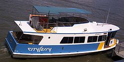
TransdevTSL Brisbane Ferries
University of Queensland
The University of Queensland, also known as UQ, is a public university located in state of Queensland, Australia. Founded in 1909, it is the oldest and largest university in Queensland and the fifth oldest in the nation...
, St Lucia
St Lucia, Queensland
St Lucia is an inner suburb of Brisbane, Australia located 4 km south-west of the Brisbane CBD. The suburb is bordered on three sides by the Brisbane River and is dominated by the main campus of the University of Queensland.-History:...
, and Apollo Road, Bulimba
Bulimba, Queensland
Bulimba is an inner suburb of Brisbane, Australia. It is 4 kilometres south-east of the CBD, and is located on the southern bank of the Brisbane River...
. The Brisbane City Council ferry fleet currently consists of 9 CityFerries and 17 CityCats. CityCats of a “3rd Generation” design were added to the fleet in 2010. A further 2 vessels will be added to the fleet by the end of 2011.
The CityCat vessels are named after the Aboriginal place names for various parts of the Brisbane River and adjacent areas. The English name is given in brackets, with the launch date. The entire CityCat fleet has been fitted with WiFi which can be accessed while on board.
The timeline of events leading up to the current arrangements commenced in 1991 when the River Connections contract was awarded by Brisbane City Council for the entire CityFerry fleet. In 1996 the River Connections contract was renewed and expanded to include the new CityCat fleet. In 2003 MetroLink Queensland, which was a joint venture between Transdev Australia
Transdev
Transdev was a major international public transport group based in Issy-les-Moulineaux near Paris, France and operating in several countries. Originally created as Société centrale pour l'équipement du territoire in 1955 and developing transportation activities since 1973, Transdev was a subsidiary...
and Transfield Services
Transfield Services
Transfield Services Limited is an Australian publicly listed corporation providing operations and maintenance, asset management, project and capital management outsourcing and infrastructure development services to the resources and industrial, infrastructure services and property and facilities...
, were awarded a 7 year contract to operate and market the CityCat and CityFerry fleets. In 2004 TransLink
TransLink (South East Queensland)
The TransLink Transit Authority is the authority introduced by the Queensland Government in June 2003 as a section of Queensland Transport to coordinate and integrate rail, bus and ferry services. TransLink works with Airtrain, Brisbane Transport, Brisbane Ferries, QR Citytrain and 17 other...
was established to coordinate the integration of the South-East Queensland public transport system which meant they took over the marketing activities of MetroLink Queensland. In 2008 the TransdevTSL Brisbane Ferries brand was established, still within the TransLink
TransLink (South East Queensland)
The TransLink Transit Authority is the authority introduced by the Queensland Government in June 2003 as a section of Queensland Transport to coordinate and integrate rail, bus and ferry services. TransLink works with Airtrain, Brisbane Transport, Brisbane Ferries, QR Citytrain and 17 other...
integrated public transport scheme, when Transfield Services and Transdev ceased the MetroLink Queensland brand.
2011 Brisbane Ferry Network Map
Moreton Bay
Services to Moreton IslandMoreton Island
Moreton Island is a large sand island on the eastern side of Moreton Bay, on the coast of south-east Queensland, Australia. Moreton Island lies 58 kilometres northeast of the Queensland capital, Brisbane. The island is 95% National Park and a popular destination for four wheel driving, camping,...
are provided by Moreton Island Adventures operates a daily 52 vehicle capacity ferry, the Moreton Island MICAT, from the Port of Brisbane
Port of Brisbane
Port of Brisbane is the shipping port of Brisbane, on the east coast of Australia. It is located in the lower reaches of the Brisbane River on reclaimed land that was once called Fisherman Islands at the mouth of the river. It currently is the third busiest port in Australia and the nation's...
to Moreton Island
Moreton Island
Moreton Island is a large sand island on the eastern side of Moreton Bay, on the coast of south-east Queensland, Australia. Moreton Island lies 58 kilometres northeast of the Queensland capital, Brisbane. The island is 95% National Park and a popular destination for four wheel driving, camping,...
Tangalooma wrecks.
Also in current operation from the port to the Tangalooma Resort are three passenger vessels
Stradbroke Ferries' Combie Trader barge service from Scarborough
Scarborough, Queensland
Scarborough is a residential suburb of the Moreton Bay Region at the northernmost of the Redcliffe peninsula, approximately north-northeast of Brisbane, the state capital of Queensland, Australia...
in Redcliffe City to Bulwer ceased in July 2008 due to matters with the terminal and landing areas.
In December 2009 a passenger-only ferry service was launched by Reality Cruises departing from the Newport Waterways Marina near Scarborough. The service operates Wednesdays to Sundays. On the southern end of the island the settlement of Kooringal which was serviced by a vehicular barge called the Kooringal Trader that ran to Amity Point
Amity Point, Queensland
Amity Point is a small close knit township located on the north western point of North Stradbroke Island, Queensland, Australia in Redland City. At the 2006 census, Amity Point had a population of 408....
on North Stradbroke Island
North Stradbroke Island
North Stradbroke Island is an Australian island in the state of Queensland, 30 km southeast of the capital Brisbane. Before 1896 the island was part of the Stradbroke Island. In that year a storm separated it from South Stradbroke Island, forming the Jumpinpin Channel. It is known...
until April 2009 when the barge was sold off due to limited business and high operation costs. A new vehicular barge called the Amity Trader now services the same route.
North Stradbroke Island
North Stradbroke Island
North Stradbroke Island is an Australian island in the state of Queensland, 30 km southeast of the capital Brisbane. Before 1896 the island was part of the Stradbroke Island. In that year a storm separated it from South Stradbroke Island, forming the Jumpinpin Channel. It is known...
services are provided by Stradbroke Ferries Ltd operates seven vehicle ferries and one water taxi
Water taxi
A water taxi or water bus, also known as a commuter boat, is a watercraft used to provide public transport, usually but not always in an urban environment. Service may be scheduled with multiple stops, operating in a similar manner to a bus, or on demand to many locations, operating in a similar...
from Cleveland
Cleveland, Queensland
Cleveland is a suburb located approximately east-south-east of Brisbane, the capital of the Australian state of Queensland, and is the council seat for the Redland City local government area...
to North Stradbroke Island
North Stradbroke Island
North Stradbroke Island is an Australian island in the state of Queensland, 30 km southeast of the capital Brisbane. Before 1896 the island was part of the Stradbroke Island. In that year a storm separated it from South Stradbroke Island, forming the Jumpinpin Channel. It is known...
and a vehicle ferry service to Lamb, Karragarra, Macleay and Russell Islands from Redland Bay
Redland Bay, Queensland
Redland Bay is a suburb south-east of Brisbane, the capital of Queensland, Australia, and is part of the Redland City local government area. It is named for the bay it sits on, which forms part of larger Moreton Bay...
. Gold Cat has three catamaran ferries used to operate a scheduled passenger ferry service from Toondah Harbour to the wharf at One Mile, Dunwich. Additionally, Transit Systems operates the Big Red Cat, a vehicle ferry from Cleveland
Cleveland, Queensland
Cleveland is a suburb located approximately east-south-east of Brisbane, the capital of the Australian state of Queensland, and is the council seat for the Redland City local government area...
to North Stradbroke Island
North Stradbroke Island
North Stradbroke Island is an Australian island in the state of Queensland, 30 km southeast of the capital Brisbane. Before 1896 the island was part of the Stradbroke Island. In that year a storm separated it from South Stradbroke Island, forming the Jumpinpin Channel. It is known...
.
Access to Coochiemudlo Island from Victoria Point
Victoria Point, Queensland
Victoria Point is a suburb located approximately south-east of Brisbane, the capital city of Queensland, Australia, in the Redland City local government area...
is either by barge or passenger services operated by Coochiemudlo Island Ferry Service.
The Southern Moreton Bay Islands is serviced by Bay Islands Transit who owns the Russell Island based Bay Island Transit (BITS) who provide a frequent foot ferry service. Four of these fast catamaran vessels run on a loop from Weinam Creek at Redland Bay catamarans to Lamb, Karragarra, Russell, Macleay
Macleay Island
Macleay Island is an island located in Moreton Bay, South East Queensland. It is in the Redland City Council Local Government Area and has the postcode 4184. Perulpa Island is a small attached to Macleay Island by a causeway....
The two newest vessels use waterjet propulsion and are designed to minimise impact on marine life. The older propeller driven ferries are to be replaced with "eco-friendly" boats in the next four years. Additionlly, Stradbroke Ferries runs three vehicle barge ferries on the same loop during daylight hours.
North Coast
Bribie Island was first serviced after a jetty was constructed at BongareeBongaree, Queensland
Bongaree is a suburb of the Moreton Bay Region in Queensland, Australia. It is located on the western side of Bribie Island, adjacent to the Pumicestone Passage. At the 2006 census, the suburb recorded a population of 14,275 persons, with a median age of 55 years..The suburb is named after the...
on Bribie Island in 1912, the SS Doomba along with SS Koopa and SS Beaver provided pleasure cruises from Brisbane to the new township of Bribie.
The SS Koopa, often referred to as the Queen of Moreton Bay, was the best known and most loved ship among the many steamers that plied the waters of Moreton Bay from the 1880s until 1953. The SS Koopa also serviced Woody Point
Woody Point, Queensland
Woody Point is a residential suburb of the Moreton Bay Region at the south-east of the Redcliffe peninsula, approximately north-northeast of Brisbane, the state capital of Queensland, Australia. It was formerly a banana plantation.-Attractions and features:...
and Redcliffe
Redcliffe, Queensland
Redcliffe is a residential suburb of the Moreton Bay Region in the north-east of the Redcliffe peninsula, approximately north-northeast of Brisbane, the state capital of Queensland, Australia...
from Brisbane. For thirty-one years Koopa did the Brisbane-Redcliffe-Bribie run carrying thousands of holiday makers. In 1942 Koopa was requisitioned by the Royal Australian Navy and commissioned on 14 September. The Navy made many alterations to the ship which served as a supply ship in New Guinea waters during the remainder of World War II. It was the tender, mother-ship and repair facility for a group of sixteen Fairmile patrol boats. Koopa returned to Brisbane in July 1945 and underwent a major naval refit. After naval service, the ship was returned to the Brisbane Tug and Steamship Company in February 1947. Trips were resumed to Redcliffe and Bribie on Sundays, Tuesdays, Thursdays and Saturday afternoons. In 1952 Koopa was bought by the Moreton Bay Development Company which continued the usual run until her final trip in May 1953. On 3 October 1960 two tugs took Koopa from the Stanley Wharf at South Brisbane to Boggy Creek, Myrtletown. A week later it was moved and placed opposite Bulwer Island where dismantling proceeded.
Services across the Noosa River are provided by the Noosa River Ferries who operate two cable ferries crossing the Noosa River
Noosa River
The Noosa River is a river situated in South East Queensland. The catchment starts in Wahpoonga Range near Mount Elliot in the coastal Great Sandy National Park and meanders south through a lakes district around Tewantin....
approximately every six minutes at Tewantin
Tewantin, Queensland
Tewantin is a suburb in Noosa, Queensland, Australia. It was the original settlement in the Noosa region and is one of its three major centres today.-History:...
. Also, the Noosa Ferry Cruise Company operates a cruise ferry service between Tewantin
Tewantin, Queensland
Tewantin is a suburb in Noosa, Queensland, Australia. It was the original settlement in the Noosa region and is one of its three major centres today.-History:...
and Noosa Heads
Noosa Heads, Queensland
Noosa Heads is one of the three major centres of the Noosa region on the Sunshine Coast, Queensland, Australia. It is located north of Brisbane, the state's capital. The Noosa River forms one boundary of the town, the headlands of the Noosa National Park another...
.
Northern
Magnetic Island was first serviced in 1899 when a service between Ross CreekRoss Creek
Ross Creek is an estuary inlet within the city of Townsville, Queensland. It separates the Townsville CBD from Ross Island. The only passage across Ross Creek was by ferry until Victoria Bridge was completed in 1889.-History:...
and Magnetic Island
Magnetic Island
Magnetic Island is an island offshore from the city of Townsville, Queensland, Australia. This mountainous island in Cleveland Bay has effectively become a suburb of Townsville, with 2,107 permanent residents. The island is accessible from Townsville Breakwater to Nelly Bay Harbour by ferry...
was commenced by the Hayles Magnetic Island Ferry Service, commenced. As of 2011, Nelly Bay Harbour, Magnetic Island, is served by 2 companies. Sealink operates passenger catamarans and Fantasea Cruising Magnetic
Fantasea
Fantasea is an Australian owned and operated tourism company providing ferry transfers and tourism excursions on the East coast of Australia.-Fantasea Adventure Cruising:...
operates a vehicular ferry.
Palm Island
Palm Island, Queensland
Palm Island is an Aboriginal community located on Great Palm Island, also called by the Aboriginal name "Bwgcolman", an island on the Great Barrier Reef in North Queensland, Australia The settlement is also known by a variety of other names including "the Mission", Palm Island Settlement or Palm...
is serviced from both Lucinda
Lucinda, Queensland
Lucinda is a coastal town in the state of Queensland, Australia, located at the southern entrance to Hinchinbrook Channel near the town of Ingham. A sugar-exporting town, Lucinda is noted for its 6km-long sugar jetty, the world's largest bulk sugar loading facility...
and Ross Creek
Ross Creek
Ross Creek is an estuary inlet within the city of Townsville, Queensland. It separates the Townsville CBD from Ross Island. The only passage across Ross Creek was by ferry until Victoria Bridge was completed in 1889.-History:...
. Day & Day Shipping provides passenger and vehicular ferries from Lucinda. Sealink operates passenger catamarans from Ross Creek.
In Townsville until the completion of the Victoria Bridge in 1889, the only passage across Ross Creek
Ross Creek
Ross Creek is an estuary inlet within the city of Townsville, Queensland. It separates the Townsville CBD from Ross Island. The only passage across Ross Creek was by ferry until Victoria Bridge was completed in 1889.-History:...
, Townsville, was by ferry. First a rowing boat and later a larger vessel was introduced into service as a result of the increase in population. Circa 1923, Kuranda plied between Townsville and Cooktown calling at Palm Island, Lucinda, Mourilyan Harbour
Mourilyan, Queensland
Mourilyan is a town in Queensland, Australia. The town is located south of Innisfail on the Bruce Highway. It was established around the Mourilyan sugar mill which provided much of the employment in the area until its destruction during Cyclone Larry on 20 March 2006...
, Cairns, Port Douglas
Port Douglas, Queensland
Port Douglas is a town in Far North Queensland, Australia, approximately north of Cairns. Its permanent population was 948 residents in 2006. The town's population can often double, however, with the influx of tourists during the peak tourism season May–September. The town is named in honour of...
and Cooktown
Cooktown, Queensland
Cooktown is a small town located at the mouth of the Endeavour River, on Cape York Peninsula in Far North Queensland where James Cook beached his ship, the Endeavour, for repairs in 1770. At the 2006 census, Cooktown had a population of 1,336...
. After receiving passengers and mail the vessel left Townsville at 1 p.m. on Mondays, arriving at Cooktown on Wednesdays. It departed at 4 p.m. the same day and arrived back in Townsville on Fridays at 4 p.m. after calling at all ports mentioned.
South Stradbroke Island
South Stradbroke IslandSouth Stradbroke Island
South Stradbroke Island is an Australian island in the state of Queensland, south of Brisbane and forms the northern end of Gold Coast. The 21 km by 2.5 km sized island is the smaller one of the two Stradbroke Islands and lies very close to the mainland. The island has hundreds of wild...
was serviced by Gold Coast Ferries from 2008 until 2011 when a resort was closed. A schedule involving a catamaran was provided between Hope Harbour, Gold Coast, to Couran Cove Island Resort .
Logan River
The following information relates to the pioneering days of crossing the Logan RiverLogan River
The Logan River is a river in South East Queensland. The catchment is dominated by urban and agricultural land use. Near the river mouth are mangrove forests and a number of aquaculture farms.-History:...
by ferry at several locations. Ferries were vital for the local communities leading up to and beyond the opening of the first bridge at Waterford
Waterford West, Queensland
Waterford West is a suburb of Logan City, Queensland, Australia.-External links:* *...
on the 15th August 1876 - ferries were required for extensive as replacement bridges were being built. The first bridge wa after intensive lobby by the communities of Waterford and Beenleigh
Beenleigh, Queensland
Beenleigh is a suburb in the Logan City area of Queensland, Australia. Beenleigh and adjoining suburbs are located near the confluence of the Logan and Albert rivers...
.
The earliest crossing of the Logan River at Waterford was Waterman’s Punt which was an unofficial ferry service established by Samuel Waterman circa 1862 at the end of Tygum Road in nowadays Waterford West. In 1863, William Stone took over using a flat-bottomed punt capable of carrying horses and cattle and also had a boat for passengers. In 1865, Henry Eden and William Stone had a dispute which led to Eden proposing to operate an official ferry service under Government regulations which led to Eden became a lessee. In 1871, Eden’s successor William Huston was unable to pay his annual lease of £35 and was forced into insolvency. By 1874, there were numerous disruptions relating to poorly maintained punts. In 1947, Waterford was victim to a major flood on Australia Day which resulted in the bridge being washed away and a ferry re-introduced while the construction of the new bridge was completed.
A Loganholme ferry service operated with a ferry house on the northern bank. People arriving on the southern bank summoned the ferry
across by ringing a bell. When the ferry was swept away by a flood in 1873 residents complained that the service was slow to resume and showed no sympathy that the ferry lessee, John McMillan, was unsuccessfully attempting to raise the punt 8 km downstream and an attempt to rent another punt failed. In 1874, minor flooding stopped the service which led to the Land Court at Beenleigh being cancelled because officials were unable to cross.
In 1870 the Alberton Ferry commenced that was used by residents in the Alberton and Carbrook
Carbrook, Queensland
Carbrook is a suburb of Logan City, Queensland, Australia. Carbrook was previously called Gramzow, a name of German origin. The German name was Anglicised during the First World War.-Cable Ski Park:...
area. Initially it was pulled by hand but was later converted to a winch. It continued to operate until World War II ceasing in 1948.
On the 5 September 1925 the ferry sunk in about 30 feet of water on the Alberton side of the river due to a large lorry, loaded with 3 tons of manufactured arrowroot from Doherty's Mill in Pimpama
Pimpama, Queensland
Pimpama is a suburb in the northern Gold Coast. It is located on the Pacific Motorway 30 km north of Surfers Paradise. The township of Pimpama is presently the last remaining rural town on the Pacific Motorway between Brisbane and the Gold Coast...
, unbalanced the ferry when being rolled onto it. The lorry was unloaded quickly and only one bag or arrowroot was damaged.
Fraser Island
In 1969, Gordon Elmer commenced the first regular vehicular ferry to Fraser Island, between Inskip and Hook Point. Prior this service it was extremely difficult to land any motor vehicle on the island. In 1970, it is estimated that only 5,000 people visited Fraser Island but by 2003 visitors had grown to 345,337 with 41,000 vehicle permits issued (excluding sand mining operation vehicles). Regular ferry services have boosted tourism visitor numbers.Barge
Landing craft
Landing craft are boats and seagoing vessels used to convey a landing force from the sea to the shore during an amphibious assault. Most renowned are those used to storm the beaches of Normandy, the Mediterranean, and many Pacific islands during WWII...
vehicular ferries provide services between the mainland and Fraser Island. Barges depart from: Inskip Point to Hook Point
Hook Point
Hook Point is the Southern most tip of Fraser Island in Queensland, Australia and the landing point for ferry services from Inskip Point....
; River Heads to Kingfisher Bay and Wanggoolba Creek
Wanggoolba Creek
Wanggoolba Creek is a fresh water creek on Fraser Island with its source in the Pile Valley and mouth on the Western shores of the island. Wanggoolba Creek at Central Station is a popular tourist destination due to the crystal clear waters flowing over white sand through a rainforest valley. Ferry...
; and Hervey Bay to Moon Point. Barges only accept four-wheel drive
Four-wheel drive
Four-wheel drive, 4WD, or 4×4 is a four-wheeled vehicle with a drivetrain that allows all four wheels to receive torque from the engine simultaneously...
s and walk-on passengers. As of 2010, foot ferries stopped servicing Fraser Island. As of 2011, the names of the ferries that service Fraser Island are barges called the Manta Ray, Rainbow Venture, Fraser Venture, Kingfisher Bay.
See also
- Bus transport in QueenslandBus transport in Queensland-Beginnings:The Brisbane Tramways Trust experimented with providing bus services in the 1920s but these proved impractical due to mechanical unreliability and Brisbane's poor road surface quality...
- Rail transport in QueenslandRail transport in QueenslandRail transport in Queensland began in 1865. Today it is one of the largest narrow gauge railway network in the world.-Public float:On 2 June 2009 the Queensland Government announced the 'Renewing Queensland Plan', with Queensland Rail's commercial activities to be separated from the Government's...
- Transport in BrisbaneTransport in BrisbaneTransport in Brisbane, the capital and largest city of Queensland, Australia, is provided by road, rail, river and bay ferries, footpaths, bikepaths, sea and air....
External links
- Official websites of TransLink and qconnect.
- Brisbane Ferry Network, 2011