

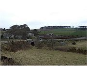
Bridge of Muchalls
Encyclopedia
Aberdeenshire
Aberdeenshire is one of the 32 unitary council areas in Scotland and a lieutenancy area.The present day Aberdeenshire council area does not include the City of Aberdeen, now a separate council area, from which its name derives. Together, the modern council area and the city formed historic...
, Scotland
Scotland
Scotland is a country that is part of the United Kingdom. Occupying the northern third of the island of Great Britain, it shares a border with England to the south and is bounded by the North Sea to the east, the Atlantic Ocean to the north and west, and the North Channel and Irish Sea to the...
by the North Sea
North Sea
In the southwest, beyond the Straits of Dover, the North Sea becomes the English Channel connecting to the Atlantic Ocean. In the east, it connects to the Baltic Sea via the Skagerrak and Kattegat, narrow straits that separate Denmark from Norway and Sweden respectively...
. It is on the A90
A90 road
The A90 road is a major north to south road in eastern Scotland, running from Edinburgh to Fraserburgh in Aberdeenshire.From Edinburgh, it travels west and over the Forth Road Bridge, before turning into the M90 motorway. At Perth, the M90 again becomes the A90, now running north east to Dundee...
dual carriageway
Dual carriageway
A dual carriageway is a class of highway with two carriageways for traffic travelling in opposite directions separated by a central reservation...
about three miles north of Stonehaven
Stonehaven
Stonehaven is a town in Aberdeenshire, Scotland. It lies on Scotland's northeast coast and had a population of 9,577 in 2001 census.Stonehaven, county town of Kincardineshire, grew around an Iron Age fishing village, now the "Auld Toon" , and expanded inland from the seaside...
and to the south of Muchalls Castle
Muchalls Castle
Muchalls Castle stands overlooking the North Sea in the countryside of Kincardine and Mearns, Aberdeenshire, Scotland. The lower course is a well preserved double groined 13th century towerhouse structure, built by the Frasers of Muchalls. Upon this structure, the 17th century castle was begun by...
.
This small hamlet is known for its picturesque access to the rugged North Sea coast
Coast
A coastline or seashore is the area where land meets the sea or ocean. A precise line that can be called a coastline cannot be determined due to the dynamic nature of tides. The term "coastal zone" can be used instead, which is a spatial zone where interaction of the sea and land processes occurs...
line at Muchalls Beach. The Burn of Muchalls
Burn of Muchalls
The Burn of Muchalls is an easterly flowing stream in Aberdeenshire, Scotland that discharges to the North Sea. Its point of discharge is on a rocky beach set with scenic sea stacks...
is a stream
Stream
A stream is a body of water with a current, confined within a bed and stream banks. Depending on its locale or certain characteristics, a stream may be referred to as a branch, brook, beck, burn, creek, "crick", gill , kill, lick, rill, river, syke, bayou, rivulet, streamage, wash, run or...
that flows east through the Bridge of Muchalls before passing under the A90 road
A90 road
The A90 road is a major north to south road in eastern Scotland, running from Edinburgh to Fraserburgh in Aberdeenshire.From Edinburgh, it travels west and over the Forth Road Bridge, before turning into the M90 motorway. At Perth, the M90 again becomes the A90, now running north east to Dundee...
way and thence to the North Sea
North Sea
In the southwest, beyond the Straits of Dover, the North Sea becomes the English Channel connecting to the Atlantic Ocean. In the east, it connects to the Baltic Sea via the Skagerrak and Kattegat, narrow straits that separate Denmark from Norway and Sweden respectively...
slightly to the north of Doonie Point
Doonie Point
Doonie Point is a rocky headland situated approximately 1.5 kilometres south of the village of Muchalls in Aberdeenshire, Scotland. The clifftop of Doonie Point yields views to the north of Grim Brigs, Brown Jewel and the coast of Newtonhill. To the south are views of the Castle Rock of Muchalls...
. The ancient Causey Mounth
Causey Mounth
The Causey Mounth is an ancient drovers' road over the coastal fringe of the Grampian Mountains in Aberdeenshire, Scotland. This route was developed as the main highway between Stonehaven and Aberdeen around the 12th century AD and it continued to function as the principal route connecting these...
trackway
Trackway
A trackway is an ancient route of travel for people or animals. In biology, a trackway can be a set of impressions in the soft earth, usually a set of footprints, left by an animal. A fossil trackway is the fossilized imprint of a trackway. Trackways have been found all over the world...
runs north from the now ruin Cowie Castle
Cowie Castle
Cowie Castle is a ruined fortress in Aberdeenshire, Scotland. The site lies at the northern end of Stonehaven near the North Sea coast. To the immediate south is the Cowie Bridge crossing of the Cowie Water. Evidence of prehistoric man exists in the vicinity dating to the Iron Age in the form of...
, past the Hill of Megray and passes over Kempstone Hill
Kempstone Hill
Kempstone Hill is a landform in Aberdeenshire, Scotland within the Mounth Range of the Grampian Mountains. The peak elevation of this mountain is 132 metres above mean sea level. This hill has been posited by Gabriel Jacques Surenne, Archibald Watt and C.Michael Hogan as the location for the...
before crossing the Burn of Muchalls at the Bridge of Muchalls.
See also
- Fetteresso CastleFetteresso CastleFetteresso Castle is a 14th century towerhouse, rebuilt in 1761 as a Scottish gothic style Palladian manor, with clear evidence of prehistoric use of the site. It is situated immediately west of the town of Stonehaven in Kincardineshire slightly to the west of the A90 dual carriageway...
- Mill of MuchallsMill of MuchallsThe Mill of Muchalls is an historic water powered mill located along the Burn of Muchalls in Aberdeenshire, Scotland. This mill is situated near to the coast of the North Sea proximate to Doonie Point. The earliest position of the village of Muchalls lay slightly to the south of the Mill of...
- Netherley
- Red Moss