
Braddock Road
Encyclopedia
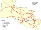
State Route 620 is a secondary state highway
in the U.S. state
of Virginia
, and traverses both Fairfax County
and Loudoun County
. The entire length of SR 620 is also known as Braddock Road (except for a small section in Centreville called Spindle Court). SR 620 also has a short concurrency with SR 659 / Union Mill Road in Centreville.
In Centreville
and Eastern Loudoun County, SR 620 is a major commuter route, as it empties onto SR 28
(Sully Rd.), which in turn has a nearby interchange with Interstate 66
. SR 620 also has major junctions with SR 123
, the Fairfax County Parkway
, and Interstate 495 (Capital Beltway)
. It has a very large number of residential neighborhoods lining the road, so most of the remainder is also a major commuter artery. The length and positioning of the highway attract motorists that are traveling from one part of Fairfax County to another.
at Columbia Pike (SR 244) near Lake Barcroft
and runs southward, crossing the Little River Turnpike. It then intersects the Capital Beltway, Interstate 495. SR 620, heading westward at this point, then passes north of Burke
and intersects SR 123 near George Mason University
. It remains well south of Fairfax City
and meets the freeway portion of the Fairfax County Parkway
. It then intersects SR 645
(Clifton Road) in Clifton
, and next meets Union Mill Road. At this point, the road becomes New Braddock Road and SR 7783. New Braddock Road continues to SR 28.
. However, SR 620 quickly turns off onto a side-street, Spindle Court, and unceremoniously dead-ends behind Mountain View Alternative High School, creating another gap. The road that was SR 620 continues ahead as Old Braddock Road, SR 7759. Old Braddock Road continues ahead to Old Centreville Road (SR 898). That road connects to the beginning of the third segment of Braddock Road, which is located at a four-way intersection with US 29
. This third segment was originally connected with what is now Spindle Court, but when a shopping center was built, a dead end on Braddock Road was created, and was renamed Spindle Ct. This segment only lasts for 0.32 mile, before turning into Pickwick Road (SR 1021).
, at an intersection with SR 28. This fourth segment of SR 620 continues to the northeast, through several residential areas. It intersects with SR 609
(Pleasant Valley Road) and enters Loudoun County
.
where it intersects with the Loudoun County Parkway
, SR 606
. It then intersects with SR 659
(Gum Spring Road). SR 620 remains a two lane paved highway until about the last 3 miles of its existence. Only then is it gravel. It ends at the intersection with SR 705 (Lightridge Farm Rd.) in Stone Ridge. Braddock Road, now designated SR 705, continues northwest to US 15
near Gilberts Corner.
Among the cities, towns and other landmarks traversed by SR 620 are:
between SR 123
and SR 620 to a full interchange. The designs being considered are diamond
, a modified diamond interchange, an SPUI, and a tight SPUI.
, and portions of the road were established prior to British colonization of northern Virginia. Although the original Braddock Road was unified throughout its length, many portions of the original road have been transected, relocated or disjointed since the original path was defined (especially since the modern paved road system was constructed).
inhabitants of Northern Virginia. Later, British colonialists and Virginian governments developed and improved the paths into what became known as "Braddock's Road."
signed by George Mason
(and after which the Bill of Rights
of the United States Constitution
was modeled), was located by the intersection of Braddock Road and Backlick Road.
Braddock Rd is so named as it was believed to be the route of the English General Edward Braddock
's force during the French and Indian War. At the outset of the Braddock Expedition
, the force was split into two groups. Braddock led the first group across the Potomac near Rock Creek and up to Frederick and Sir Peter Halkett led a second group through Northern Virginia
. Halkett's group marched past the Old Fairfax County courthouse (today Tysons Corner) and up to Coleman's Ordinary (today Northern Herndon, Virginia
). It is unlikely that today's Braddock Road was the actual route taken by Halkett's group. Rather, they roughly followed the route of present-day Leesburg Pike (Route 7).
troops traversed Braddock Road during various battles in Fairfax County and other parts of Northern Virginia.
One of Mosby's Raiders, Robert Spindle, was a native of Centreville. Later, the part of SR 620 that was formed when Braddock Road was cut at US 29 was named after him, Spindle Court.
In the 1960s I-66 was built coming through Centreville. At this point the section of SR 620 between SR28 south of I-66 and a point north of the new I-66 was deleted, and a new SR 620 entrance was created intersecting with SR 28 north of I-66.
When SR 28 was widened from a 4-lane highway to a 6-lane one SR 620 was changed again. SR 620 south of I-66 no longer intersected with SR 28; SR 620 ended where Willoughby Newton Drive is now.
In the 1980s a shopping center was built at the corner of U.S. 29 and Old Centreville Road. At that time the non-SR 620 section of Braddock Road was constructed linking SR 620 to Old Centreville Road. The intersection between SR 620 and U.S. 29 was cut, and this small portion of SR 620 was renamed Spindle Court.
In the 1990s New Braddock Road was constructed linking Union Mill Road to SR 28. This is when SR 620 was cut, so that, on the east side of Union Mill Road, the road is Braddock Road, and on the west side it's New Braddock Road. Braddock Road heading west now intersects with Union Mill Road one block to the north.
The final change came in 2009. A barrier was erected on SR 28 that forced all traffic coming from SR 620 from the west to turn south on SR 28.
State highway
State highway, state road or state route can refer to one of three related concepts, two of them related to a state or provincial government in a country that is divided into states or provinces :#A...
in the U.S. state
U.S. state
A U.S. state is any one of the 50 federated states of the United States of America that share sovereignty with the federal government. Because of this shared sovereignty, an American is a citizen both of the federal entity and of his or her state of domicile. Four states use the official title of...
of Virginia
Virginia
The Commonwealth of Virginia , is a U.S. state on the Atlantic Coast of the Southern United States. Virginia is nicknamed the "Old Dominion" and sometimes the "Mother of Presidents" after the eight U.S. presidents born there...
, and traverses both Fairfax County
Fairfax County, Virginia
Fairfax County is a county in Virginia, in the United States. Per the 2010 Census, the population of the county is 1,081,726, making it the most populous jurisdiction in the Commonwealth of Virginia, with 13.5% of Virginia's population...
and Loudoun County
Loudoun County, Virginia
Loudoun County is a county located in the Commonwealth of Virginia, and is part of the Washington Metropolitan Area. As of the 2010 U.S. Census, the county is estimated to be home to 312,311 people, an 84 percent increase over the 2000 figure of 169,599. That increase makes the county the fourth...
. The entire length of SR 620 is also known as Braddock Road (except for a small section in Centreville called Spindle Court). SR 620 also has a short concurrency with SR 659 / Union Mill Road in Centreville.
In Centreville
Centreville, Virginia
Centreville is an unincorporated community in Fairfax County, Virginia, United States. Recognized by the U.S. Census Bureau as a Census Designated Place , the community population was 71,135 as of the 2010 census and is approximately west of Washington, DC.-Colonial Period:Beginning in the 1760s,...
and Eastern Loudoun County, SR 620 is a major commuter route, as it empties onto SR 28
Virginia State Route 28
State Route 28 is a primary state highway that traverses the counties of Loudoun, Fairfax, Prince William, and Fauquier in the U.S. state of Virginia. It is a major artery through Northern Virginia.-Loudoun County:...
(Sully Rd.), which in turn has a nearby interchange with Interstate 66
Interstate 66
Interstate 66 is an Interstate Highway in the eastern United States. As indicated by its even route number, it runs in an east–west direction. Its western terminus is at Middletown, Virginia, at an intersection with Interstate 81; its eastern terminus is in Washington, D.C., at an...
. SR 620 also has major junctions with SR 123
Virginia State Route 123
Virginia State Route 123 is a primary state highway in the U.S. state of Virginia. The state highway runs from U.S. Route 1 in Woodbridge north to the Chain Bridge across the Potomac River into Washington from Arlington...
, the Fairfax County Parkway
Fairfax County Parkway
The Fairfax County Parkway, signed as State Route 7100, is a secondary state highway in the U.S. state of Virginia. It provides a north–south arterial route in Fairfax County with a mix of interchanges and signalized and unsignalized intersections. Its alignment roughly corresponds to part of...
, and Interstate 495 (Capital Beltway)
Interstate 495 (Capital Beltway)
Interstate 495 is a Interstate Highway that surrounds the United States' capital of Washington, D.C., and its inner suburbs in adjacent Maryland and Virginia. I-495 is widely known as the Capital Beltway or simply the Beltway, especially when the context of Washington, D.C., is clear...
. It has a very large number of residential neighborhoods lining the road, so most of the remainder is also a major commuter artery. The length and positioning of the highway attract motorists that are traveling from one part of Fairfax County to another.
East and Central Fairfax County
SR 620 begins in Fairfax CountyFairfax County, Virginia
Fairfax County is a county in Virginia, in the United States. Per the 2010 Census, the population of the county is 1,081,726, making it the most populous jurisdiction in the Commonwealth of Virginia, with 13.5% of Virginia's population...
at Columbia Pike (SR 244) near Lake Barcroft
Lake Barcroft, Virginia
Lake Barcroft is a census-designated place in Fairfax County, Virginia, United States. The population was 8,906 at the 2000 census. It is also the name of the privately-owned lake around which this population is located. The lake is named for Dr. John W...
and runs southward, crossing the Little River Turnpike. It then intersects the Capital Beltway, Interstate 495. SR 620, heading westward at this point, then passes north of Burke
Burke, Virginia
-Demographics:As of the census of 2000, there were 57,737 people, 19,215 households, and 15,756 families residing in the community. Burke is the largest community in Virginia recognized by the Census Bureau, other than counties and incorporated cities . The population density was 5,008.0 people per...
and intersects SR 123 near George Mason University
George Mason University
George Mason University is a public university based in unincorporated Fairfax County, Virginia, United States, south of and adjacent to the city of Fairfax. Additional campuses are located nearby in Arlington County, Prince William County, and Loudoun County...
. It remains well south of Fairfax City
Fairfax, Virginia
The City of Fairfax is an independent city forming an enclave within the confines of Fairfax County, in the Commonwealth of Virginia in the United States. Although politically independent of the surrounding county, the City is nevertheless the county seat....
and meets the freeway portion of the Fairfax County Parkway
Fairfax County Parkway
The Fairfax County Parkway, signed as State Route 7100, is a secondary state highway in the U.S. state of Virginia. It provides a north–south arterial route in Fairfax County with a mix of interchanges and signalized and unsignalized intersections. Its alignment roughly corresponds to part of...
. It then intersects SR 645
Virginia State Route 645 (Fairfax County)
Virginia Secondary Route 645 is a major secondary road completely within the bounds of western Fairfax County, Virginia. There are six portions, three of them being major, named Wall Road, Lees Corner Road, Stringfellow Road, Clifton Road, Main Street and Burke Lake Road...
(Clifton Road) in Clifton
Clifton, Virginia
Clifton is a town in Fairfax County, Virginia, United States located away from Washington, D.C. In 2010, the population was 282.-Pre-Colonial era:...
, and next meets Union Mill Road. At this point, the road becomes New Braddock Road and SR 7783. New Braddock Road continues to SR 28.
In Centreville
While New Braddock Road continues straight, SR 620 itself is concurrent with SR 659 / Union Mill Road for one block. A new segment of Braddock Road (which shortly matches the old alignment of Braddock Road) starts here and heads west into CentrevilleCentreville, Virginia
Centreville is an unincorporated community in Fairfax County, Virginia, United States. Recognized by the U.S. Census Bureau as a Census Designated Place , the community population was 71,135 as of the 2010 census and is approximately west of Washington, DC.-Colonial Period:Beginning in the 1760s,...
. However, SR 620 quickly turns off onto a side-street, Spindle Court, and unceremoniously dead-ends behind Mountain View Alternative High School, creating another gap. The road that was SR 620 continues ahead as Old Braddock Road, SR 7759. Old Braddock Road continues ahead to Old Centreville Road (SR 898). That road connects to the beginning of the third segment of Braddock Road, which is located at a four-way intersection with US 29
U.S. Route 29
U.S. Route 29 is a north–south United States highway that runs for from the western suburbs of Baltimore, Maryland, to Pensacola, Florida. This highway's northern terminus is at Maryland Route 99 in Ellicott City, Maryland...
. This third segment was originally connected with what is now Spindle Court, but when a shopping center was built, a dead end on Braddock Road was created, and was renamed Spindle Ct. This segment only lasts for 0.32 mile, before turning into Pickwick Road (SR 1021).
Western Fairfax County
Braddock Road picks up again on the other side of I-66Interstate 66
Interstate 66 is an Interstate Highway in the eastern United States. As indicated by its even route number, it runs in an east–west direction. Its western terminus is at Middletown, Virginia, at an intersection with Interstate 81; its eastern terminus is in Washington, D.C., at an...
, at an intersection with SR 28. This fourth segment of SR 620 continues to the northeast, through several residential areas. It intersects with SR 609
Virginia State Route 609 (Fairfax County)
State Route 609 is a secondary state highway in the U.S. state of Virginia, and traverses western Fairfax County. The road is also known as Pleasant Valley Road.-Route description:...
(Pleasant Valley Road) and enters Loudoun County
Loudoun County, Virginia
Loudoun County is a county located in the Commonwealth of Virginia, and is part of the Washington Metropolitan Area. As of the 2010 U.S. Census, the county is estimated to be home to 312,311 people, an 84 percent increase over the 2000 figure of 169,599. That increase makes the county the fourth...
.
Loudoun County
Keeping the SR 620 designation, Braddock Road forms the southern border of South RidingSouth Riding, Virginia
South Riding is a census-designated place and planned community in Loudoun County, Virginia. The population as of the 2010 Census was 24,256.. Neighboring U.S. Route 50 and State Route 28 provide access to the Dulles/Reston/Tysons Corner technology corridor and other major employment centers in...
where it intersects with the Loudoun County Parkway
Loudoun County Parkway
The Loudoun County Parkway is a secondary state highway in eastern Loudoun County, Virginia. Two sections of the route currently exist, a southern portion signed as State Route 606 from Braddock Road north to Arcola Road which continues east as Old Ox Road, and a northern portion in Ashburn signed...
, SR 606
Virginia State Route 606 (Fairfax and Loudoun Counties)
State Route 606 is a secondary state highway in the U.S. state of Virginia, and traverses Fairfax County and Loudoun County. This route goes through Reston and Herndon in Fairfax County, and Sterling and Arcola in Loudoun County...
. It then intersects with SR 659
Virginia State Route 659 (Loudoun County)
Virginia Secondary Route 659, otherwise known as Belmont Ridge Road north of Arcola, and Gum Spring Road to the south, is a Virginia Department of Transportation maintained and administered road in the Washington D.C. Metropolitan Area...
(Gum Spring Road). SR 620 remains a two lane paved highway until about the last 3 miles of its existence. Only then is it gravel. It ends at the intersection with SR 705 (Lightridge Farm Rd.) in Stone Ridge. Braddock Road, now designated SR 705, continues northwest to US 15
U.S. Route 15
U.S. Route 15 is a -long United States highway, designated along South Carolina, North Carolina, Virginia, Maryland, Pennsylvania, and New York. The route is signed north–south, from U.S. Route 17 Alternate in Walterboro, South Carolina to Interstate 86 and NY 17 in Painted Post, New York.US...
near Gilberts Corner.
Among the cities, towns and other landmarks traversed by SR 620 are:
- the Thomas Jefferson High School for Science and TechnologyThomas Jefferson High School for Science and TechnologyThomas Jefferson High School for Science and Technology is a Virginia state-chartered magnet school located within Fairfax County, Virginia, United States...
lies near the intersection with Little River TurnpikeVirginia State Route 236State Route 236, also known for part of its length as Little River Turnpike, is a primary state highway in the Commonwealth of Virginia. It runs from the split of U.S. Route 29 and U.S... - AnnandaleAnnandale, VirginiaAnnandale is a census-designated place in Fairfax County, Virginia, United States. The population was 41,008 at the 2010 census, down from 54,994 in 2000 due to the splitting off of the western part of it to form Wakefield and Woodburn CDP's.-Geography:...
- an intersection with the Capital BeltwayInterstate 495 (Capital Beltway)Interstate 495 is a Interstate Highway that surrounds the United States' capital of Washington, D.C., and its inner suburbs in adjacent Maryland and Virginia. I-495 is widely known as the Capital Beltway or simply the Beltway, especially when the context of Washington, D.C., is clear...
- BurkeBurke, Virginia-Demographics:As of the census of 2000, there were 57,737 people, 19,215 households, and 15,756 families residing in the community. Burke is the largest community in Virginia recognized by the Census Bureau, other than counties and incorporated cities . The population density was 5,008.0 people per...
- George Mason UniversityGeorge Mason UniversityGeorge Mason University is a public university based in unincorporated Fairfax County, Virginia, United States, south of and adjacent to the city of Fairfax. Additional campuses are located nearby in Arlington County, Prince William County, and Loudoun County...
- CentrevilleCentreville, VirginiaCentreville is an unincorporated community in Fairfax County, Virginia, United States. Recognized by the U.S. Census Bureau as a Census Designated Place , the community population was 71,135 as of the 2010 census and is approximately west of Washington, DC.-Colonial Period:Beginning in the 1760s,...
- Sully Station
- South RidingSouth Riding, VirginiaSouth Riding is a census-designated place and planned community in Loudoun County, Virginia. The population as of the 2010 Census was 24,256.. Neighboring U.S. Route 50 and State Route 28 provide access to the Dulles/Reston/Tysons Corner technology corridor and other major employment centers in...
Future construction
Fairfax County is considering changing the intersectionIntersection (road)
An intersection is a road junction where two or more roads either meet or cross at grade . An intersection may be 3-way - a T junction or fork, 4-way - a crossroads, or 5-way or more...
between SR 123
Virginia State Route 123
Virginia State Route 123 is a primary state highway in the U.S. state of Virginia. The state highway runs from U.S. Route 1 in Woodbridge north to the Chain Bridge across the Potomac River into Washington from Arlington...
and SR 620 to a full interchange. The designs being considered are diamond
Diamond interchange
A diamond interchange is a common type of road junction, used where a freeway crosses a minor road. The freeway itself is grade-separated from the minor road, one crossing the other over a bridge...
, a modified diamond interchange, an SPUI, and a tight SPUI.
History
Historically, SR 620 was known as Braddock Road. The road has historical significance in the American Civil WarAmerican Civil War
The American Civil War was a civil war fought in the United States of America. In response to the election of Abraham Lincoln as President of the United States, 11 southern slave states declared their secession from the United States and formed the Confederate States of America ; the other 25...
, and portions of the road were established prior to British colonization of northern Virginia. Although the original Braddock Road was unified throughout its length, many portions of the original road have been transected, relocated or disjointed since the original path was defined (especially since the modern paved road system was constructed).
Establishment, including pre-colonization era
Braddock Road was originally composed of paths established by the Native AmericanNative Americans in the United States
Native Americans in the United States are the indigenous peoples in North America within the boundaries of the present-day continental United States, parts of Alaska, and the island state of Hawaii. They are composed of numerous, distinct tribes, states, and ethnic groups, many of which survive as...
inhabitants of Northern Virginia. Later, British colonialists and Virginian governments developed and improved the paths into what became known as "Braddock's Road."
Colonial and revolutionary era
Price's Common, a market that operated during the colonial administration and was the site of the drafting of the Virginia Declaration of RightsVirginia Declaration of Rights
The Virginia Declaration of Rights is a document drafted in 1776 to proclaim the inherent rights of men, including the right to rebel against "inadequate" government...
signed by George Mason
George Mason
George Mason IV was an American Patriot, statesman and a delegate from Virginia to the U.S. Constitutional Convention...
(and after which the Bill of Rights
Bill of rights
A bill of rights is a list of the most important rights of the citizens of a country. The purpose of these bills is to protect those rights against infringement. The term "bill of rights" originates from England, where it referred to the Bill of Rights 1689. Bills of rights may be entrenched or...
of the United States Constitution
United States Constitution
The Constitution of the United States is the supreme law of the United States of America. It is the framework for the organization of the United States government and for the relationship of the federal government with the states, citizens, and all people within the United States.The first three...
was modeled), was located by the intersection of Braddock Road and Backlick Road.
Braddock Rd is so named as it was believed to be the route of the English General Edward Braddock
Edward Braddock
General Edward Braddock was a British soldier and commander-in-chief for the 13 colonies during the actions at the start of the French and Indian War...
's force during the French and Indian War. At the outset of the Braddock Expedition
Braddock expedition
The Braddock expedition, also called Braddock's campaign or, more commonly, Braddock's Defeat, was a failed British military expedition which attempted to capture the French Fort Duquesne in the summer of 1755 during the French and Indian War. It was defeated at the Battle of the Monongahela on...
, the force was split into two groups. Braddock led the first group across the Potomac near Rock Creek and up to Frederick and Sir Peter Halkett led a second group through Northern Virginia
Northern Virginia
Northern Virginia consists of several counties and independent cities in the Commonwealth of Virginia, in a widespread region generally radiating southerly and westward from Washington, D.C...
. Halkett's group marched past the Old Fairfax County courthouse (today Tysons Corner) and up to Coleman's Ordinary (today Northern Herndon, Virginia
Herndon, Virginia
Herndon is a town in Fairfax County, Virginia, in the Washington, D.C. metropolitan area of the United States. The population was 21,655 at the 2000 census, which makes it the largest of three towns in the county.-History:...
). It is unlikely that today's Braddock Road was the actual route taken by Halkett's group. Rather, they roughly followed the route of present-day Leesburg Pike (Route 7).
Civil War
During the American Civil War, both Union and ConfederateConfederate States of America
The Confederate States of America was a government set up from 1861 to 1865 by 11 Southern slave states of the United States of America that had declared their secession from the U.S...
troops traversed Braddock Road during various battles in Fairfax County and other parts of Northern Virginia.
One of Mosby's Raiders, Robert Spindle, was a native of Centreville. Later, the part of SR 620 that was formed when Braddock Road was cut at US 29 was named after him, Spindle Court.
The Modern Era
With the advent of the modern road system, Braddock Road changed. In the 1930s after the Virginia Secondary Road system was created Braddock Road in Fairfax and Loudoun Counties was given the designation SR 620.In the 1960s I-66 was built coming through Centreville. At this point the section of SR 620 between SR28 south of I-66 and a point north of the new I-66 was deleted, and a new SR 620 entrance was created intersecting with SR 28 north of I-66.
When SR 28 was widened from a 4-lane highway to a 6-lane one SR 620 was changed again. SR 620 south of I-66 no longer intersected with SR 28; SR 620 ended where Willoughby Newton Drive is now.
In the 1980s a shopping center was built at the corner of U.S. 29 and Old Centreville Road. At that time the non-SR 620 section of Braddock Road was constructed linking SR 620 to Old Centreville Road. The intersection between SR 620 and U.S. 29 was cut, and this small portion of SR 620 was renamed Spindle Court.
In the 1990s New Braddock Road was constructed linking Union Mill Road to SR 28. This is when SR 620 was cut, so that, on the east side of Union Mill Road, the road is Braddock Road, and on the west side it's New Braddock Road. Braddock Road heading west now intersects with Union Mill Road one block to the north.
The final change came in 2009. A barrier was erected on SR 28 that forced all traffic coming from SR 620 from the west to turn south on SR 28.
Major intersections
| County | Location | Mile | Destinations | Notes |
|---|---|---|---|---|
| Fairfax Fairfax County, Virginia Fairfax County is a county in Virginia, in the United States. Per the 2010 Census, the population of the county is 1,081,726, making it the most populous jurisdiction in the Commonwealth of Virginia, with 13.5% of Virginia's population... |
Braddock Rd. (East & Central Fairfax) | |||
| Alexandria Alexandria, Virginia Alexandria is an independent city in the Commonwealth of Virginia. As of 2009, the city had a total population of 139,966. Located along the Western bank of the Potomac River, Alexandria is approximately six miles south of downtown Washington, D.C.Like the rest of northern Virginia, as well as... / Falls Church Falls Church, Virginia The City of Falls Church is an independent city in Virginia, United States, in the Washington Metropolitan Area. The city population was 12,332 in 2010, up from 10,377 in 2000. Taking its name from The Falls Church, an 18th-century Anglican parish, Falls Church gained township status within... ZIP code boundary |
0.00 | East terminus of SR 620 | ||
| Alexandria Alexandria, Virginia Alexandria is an independent city in the Commonwealth of Virginia. As of 2009, the city had a total population of 139,966. Located along the Western bank of the Potomac River, Alexandria is approximately six miles south of downtown Washington, D.C.Like the rest of northern Virginia, as well as... ZIP code |
1.44 | |||
| Annandale Annandale, Virginia Annandale is a census-designated place in Fairfax County, Virginia, United States. The population was 41,008 at the 2010 census, down from 54,994 in 2000 due to the splitting off of the western part of it to form Wakefield and Woodburn CDP's.-Geography:... / Springfield Springfield, Virginia Springfield is a census-designated place in Fairfax County, Virginia, United States and a suburb of Washington, D.C. The Springfield CDP is recognized by the U.S. Census Bureau with a population of 30,484 as of the 2010 census. Homes and businesses in bordering CDPs including North Springfield,... |
4.74 | , Maryland Maryland Maryland is a U.S. state located in the Mid Atlantic region of the United States, bordering Virginia, West Virginia, and the District of Columbia to its south and west; Pennsylvania to its north; and Delaware to its east... |
||
| Fairfax Fairfax, Virginia The City of Fairfax is an independent city forming an enclave within the confines of Fairfax County, in the Commonwealth of Virginia in the United States. Although politically independent of the surrounding county, the City is nevertheless the county seat.... |
10.71 | |||
| 13.86 | ||||
| Centreville Centreville, Virginia Centreville is an unincorporated community in Fairfax County, Virginia, United States. Recognized by the U.S. Census Bureau as a Census Designated Place , the community population was 71,135 as of the 2010 census and is approximately west of Washington, DC.-Colonial Period:Beginning in the 1760s,... / Clifton Clifton, Virginia Clifton is a town in Fairfax County, Virginia, United States located away from Washington, D.C. In 2010, the population was 282.-Pre-Colonial era:... |
16.28 | SR 659 (Union Mill Road) - Centreville Centreville, Virginia Centreville is an unincorporated community in Fairfax County, Virginia, United States. Recognized by the U.S. Census Bureau as a Census Designated Place , the community population was 71,135 as of the 2010 census and is approximately west of Washington, DC.-Colonial Period:Beginning in the 1760s,... , Clifton Clifton, Virginia Clifton is a town in Fairfax County, Virginia, United States located away from Washington, D.C. In 2010, the population was 282.-Pre-Colonial era:... |
West: New Braddock Road; SR 620 is one block north. Begin 0.15 mile concurrency with SR 659 (Union Mill Road) | |
| Braddock Rd. (Centreville) | ||||
| Centreville Centreville, Virginia Centreville is an unincorporated community in Fairfax County, Virginia, United States. Recognized by the U.S. Census Bureau as a Census Designated Place , the community population was 71,135 as of the 2010 census and is approximately west of Washington, DC.-Colonial Period:Beginning in the 1760s,... / Clifton Clifton, Virginia Clifton is a town in Fairfax County, Virginia, United States located away from Washington, D.C. In 2010, the population was 282.-Pre-Colonial era:... |
16.43 | SR 659 (Union Mill Road) - Centreville Centreville, Virginia Centreville is an unincorporated community in Fairfax County, Virginia, United States. Recognized by the U.S. Census Bureau as a Census Designated Place , the community population was 71,135 as of the 2010 census and is approximately west of Washington, DC.-Colonial Period:Beginning in the 1760s,... , Clifton Clifton, Virginia Clifton is a town in Fairfax County, Virginia, United States located away from Washington, D.C. In 2010, the population was 282.-Pre-Colonial era:... |
End 0.15 mile concurrency with SR 659 (Union Mill Road) | |
| Centreville Centreville, Virginia Centreville is an unincorporated community in Fairfax County, Virginia, United States. Recognized by the U.S. Census Bureau as a Census Designated Place , the community population was 71,135 as of the 2010 census and is approximately west of Washington, DC.-Colonial Period:Beginning in the 1760s,... |
17.18 | Spindle Court / Braddock Road - Centreville Centreville, Virginia Centreville is an unincorporated community in Fairfax County, Virginia, United States. Recognized by the U.S. Census Bureau as a Census Designated Place , the community population was 71,135 as of the 2010 census and is approximately west of Washington, DC.-Colonial Period:Beginning in the 1760s,... |
Turn onto Spindle Court for SR 620 | |
| Spindle Court (Centreville) | ||||
| Centreville Centreville, Virginia Centreville is an unincorporated community in Fairfax County, Virginia, United States. Recognized by the U.S. Census Bureau as a Census Designated Place , the community population was 71,135 as of the 2010 census and is approximately west of Washington, DC.-Colonial Period:Beginning in the 1760s,... |
17.42 |  cul-de-sac Cul-de-sac A cul-de-sac is a word of French origin referring to a dead end, close, no through road or court meaning dead-end street with only one inlet/outlet... ; SR 620 continues in the next segment. |
Spindle Court is a dead end. | |
| GAP Braddock Road (North of U.S. 29) |
||||
| Centreville Centreville, Virginia Centreville is an unincorporated community in Fairfax County, Virginia, United States. Recognized by the U.S. Census Bureau as a Census Designated Place , the community population was 71,135 as of the 2010 census and is approximately west of Washington, DC.-Colonial Period:Beginning in the 1760s,... |
17.42 | Begins this section | ||
| 17.74 |  SR 1021 (Pickwick Road) - Centreville SR 1021 (Pickwick Road) - CentrevilleCentreville, Virginia Centreville is an unincorporated community in Fairfax County, Virginia, United States. Recognized by the U.S. Census Bureau as a Census Designated Place , the community population was 71,135 as of the 2010 census and is approximately west of Washington, DC.-Colonial Period:Beginning in the 1760s,... |
Ends this section | ||
| GAP Braddock Road (West of SR 28 - Sully Road) |
||||
| Centreville Centreville, Virginia Centreville is an unincorporated community in Fairfax County, Virginia, United States. Recognized by the U.S. Census Bureau as a Census Designated Place , the community population was 71,135 as of the 2010 census and is approximately west of Washington, DC.-Colonial Period:Beginning in the 1760s,... |
17.74 | Beginning of section; barricade prevents crossing onto Walney Road or turning north. | ||
| 21.73 | SR 609 Virginia State Route 609 (Fairfax County) State Route 609 is a secondary state highway in the U.S. state of Virginia, and traverses western Fairfax County. The road is also known as Pleasant Valley Road.-Route description:... (Pleasant Valley Road) - Centreville Centreville, Virginia Centreville is an unincorporated community in Fairfax County, Virginia, United States. Recognized by the U.S. Census Bureau as a Census Designated Place , the community population was 71,135 as of the 2010 census and is approximately west of Washington, DC.-Colonial Period:Beginning in the 1760s,... , Sterling Sterling, Virginia Sterling, Virginia is a census-designated place in Loudoun County, Virginia. The population as of the 2010 Census was 27,822.It is located northwest of Herndon, east of Ashburn, and west of Great Falls, and includes part of Dulles International Airport and the former AOL corporate headquarters... |
|||
| Loudoun Loudoun County, Virginia Loudoun County is a county located in the Commonwealth of Virginia, and is part of the Washington Metropolitan Area. As of the 2010 U.S. Census, the county is estimated to be home to 312,311 people, an 84 percent increase over the 2000 figure of 169,599. That increase makes the county the fourth... |
Chantilly Chantilly, Virginia Chantilly is an unincorporated community located in western Fairfax County and southeastern Loudoun County of Northern Virginia. Recognized by the U.S. Census Bureau as a census designated place , the community population was 23,039 as of the 2010 census -- down from 41,041 in 2000, due to the... |
24.62 | SR 606 Virginia State Route 606 (Fairfax and Loudoun Counties) State Route 606 is a secondary state highway in the U.S. state of Virginia, and traverses Fairfax County and Loudoun County. This route goes through Reston and Herndon in Fairfax County, and Sterling and Arcola in Loudoun County... (Loudoun County Parkway Loudoun County Parkway The Loudoun County Parkway is a secondary state highway in eastern Loudoun County, Virginia. Two sections of the route currently exist, a southern portion signed as State Route 606 from Braddock Road north to Arcola Road which continues east as Old Ox Road, and a northern portion in Ashburn signed... ) - South Riding South Riding, Virginia South Riding is a census-designated place and planned community in Loudoun County, Virginia. The population as of the 2010 Census was 24,256.. Neighboring U.S. Route 50 and State Route 28 provide access to the Dulles/Reston/Tysons Corner technology corridor and other major employment centers in... , Dulles Airport, Herndon Herndon, Virginia Herndon is a town in Fairfax County, Virginia, in the Washington, D.C. metropolitan area of the United States. The population was 21,655 at the 2000 census, which makes it the largest of three towns in the county.-History:... |
Intersection is at the South Riding south entrance. |
| 25.41 | SR 659 Virginia State Route 659 (Loudoun County) Virginia Secondary Route 659, otherwise known as Belmont Ridge Road north of Arcola, and Gum Spring Road to the south, is a Virginia Department of Transportation maintained and administered road in the Washington D.C. Metropolitan Area... (Gum Spring Road) - Arcola Arcola, Virginia Arcola is a census-designated place in Loudoun County, Virginia, USA. The population as of the 2010 Census was 233.Leesburg is situated northwest of Arcola; the national capital, Washington, D.C., lies to the east.-History:... , Manassas Manassas, Virginia The City of Manassas is an independent city surrounded by Prince William County and the independent city of Manassas Park in the Commonwealth of Virginia in the United States. Its population was 37,821 as of 2010. Manassas also surrounds the county seat for Prince William County but that county... |
|||
| Stone Ridge Stone Ridge, Virginia Stone Ridge is a census-designated place located near Arcola in Loudoun County, Virginia near Washington Dulles International Airport. The population as of the 2010 Census was 7,214... |
27.71 | West terminus of SR 620. Braddock Road continues as SR 705. | ||