

Bethells Bridge
Encyclopedia
Swing bridge
A swing bridge is a movable bridge that has as its primary structural support a vertical locating pin and support ring, usually at or near to its centre of gravity, about which the turning span can then pivot horizontally as shown in the animated illustration to the right...
on the Driffield Navigation
Driffield Navigation
The Driffield Navigation is an waterway, through the heart of the Holderness Plain to the market town of Driffield, East Riding of Yorkshire, England. The northern section of it is a canal, and the southern section is part of the River Hull. Construction was authorised in 1767, and it was fully...
in the East Riding of Yorkshire
East Riding of Yorkshire
The East Riding of Yorkshire, or simply East Yorkshire, is a local government district with unitary authority status, and a ceremonial county of England. For ceremonial purposes the county also includes the city of Kingston upon Hull, which is a separate unitary authority...
, England
England
England is a country that is part of the United Kingdom. It shares land borders with Scotland to the north and Wales to the west; the Irish Sea is to the north west, the Celtic Sea to the south west, with the North Sea to the east and the English Channel to the south separating it from continental...
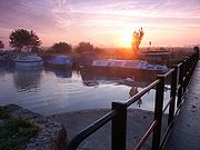
. The bridge was built to access land cut off after a new section of canal was made. It is now home to many boat moorings, and popular with fishermen.
Location
Near the small hamletHamlet (place)
A hamlet is usually a rural settlement which is too small to be considered a village, though sometimes the word is used for a different sort of community. Historically, when a hamlet became large enough to justify building a church, it was then classified as a village...
of Hempholme
Hempholme
Hempholme is a hamlet in the East Riding of Yorkshire, England, in an area known as Holderness. It is situated approximately north east of Beverley town centre.It lies east of the Driffield Navigation.-Governance:...
, this bridge crosses the Driffield Navigation
Driffield Navigation
The Driffield Navigation is an waterway, through the heart of the Holderness Plain to the market town of Driffield, East Riding of Yorkshire, England. The northern section of it is a canal, and the southern section is part of the River Hull. Construction was authorised in 1767, and it was fully...
between Struncheon Hill Lock
Struncheon Hill Lock
Struncheon Hill Lock was built as a later addition to the Driffield Navigation in the East Riding of Yorkshire, England. It improved access to the next section of water during low tide conditions, and is the first lock...
to the south, and Emmotland
Emmotland
Emmotland is a small hamlet on the North Frodingham Carrs in the East Riding of Yorkshire, England. It consists of a couple of farms at the end of a small access road. West Beck joins the Driffield Navigation here....
to the north. A small lane from Brandesburton
Brandesburton
Brandesburton is a village and civil parish in the East Riding of Yorkshire, England. It is situated approximately west of Hornsea and north-east of the market town of Beverley....
, passing through Burshill
Burshill
Burshill is a hamlet in the East Riding of Yorkshire, England. It is situated approximately north east of the market town of Beverley.It forms part of the civil parish of Brandesburton.-Governance:...
is the only public access to the bridge.
Situated on the Driffield Navigation
- Next place upstream = EmmotlandEmmotlandEmmotland is a small hamlet on the North Frodingham Carrs in the East Riding of Yorkshire, England. It consists of a couple of farms at the end of a small access road. West Beck joins the Driffield Navigation here....
- Next place downstream = Struncheon Hill LockStruncheon Hill LockStruncheon Hill Lock was built as a later addition to the Driffield Navigation in the East Riding of Yorkshire, England. It improved access to the next section of water during low tide conditions, and is the first lock...
History
During the navigation improvements of 1803–1811, a new lock cut was made to bypass a large meandering loop of the River HullRiver Hull
The River Hull is a navigable river in the East Riding of Yorkshire in the north of England. It rises from a series of springs to the west of Driffield, and enters the Humber estuary at Kingston upon Hull. Following a period when the Archbishops of York charged tolls for its use, it became a free...
around Struncheon Hill. Mr Richard Bethell, who owned the Leven Canal
Leven Canal
The Leven Canal canal runs for from the River Hull to the village of Leven, East Riding of Yorkshire, England. It was built for Mrs Charlotta Bethell in 1805, and remained in use until 1935. It is now a Site of Special Scientific Interest.-Location:...
, also owned the land around this cutting, and needed a bridge to access his land.
William Chapman, who carried out the works, decided on a swing bridge, as was in common use in the rest of the navigation, but since the cut was made wide to accommodate the flow of the river, a fixed section was used to reduce the size of the opening section.
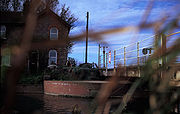
At the same time, a bridge-keepers house was built, presently known as Swing Bridge Cottage. When the traffic dropped on the Driffield Navigation, the bridge keeper was no longer needed and the house was left empty. In the early 1970s Colin Askin occupied the property, and restored and improved the house, raising his family there.
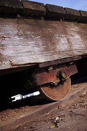
Without regular maintenance, the bride started to deteriorate in the 1950s. The wood warped, and became inoperable some time in the late 1960s.
In 1978, on a cold December night, a large lorry crossed the bridge, and made it unsafe. As this bridge was a vital link for the milk lorry which served the farms, and also a short cut for other farm traffic the local farmers - Richard Southwell from Rotsea Carr farm, Mike and Ben Southwell from Hunts Hill farm (all brothers), and Mr Keith Conner from Struncheon Hill farm, along with Colin Askin and other members of the Driffield Navigation Amenities Association helped replace, and repair the structure.
Around that time, Bethells Bridge Boat Club was also founded, and had their first AGM in 1979. The BBBC used Ben Southwell's land along the bank above the bridge for moorings. In later years, other farmers started letting out moorings on their banks, so there are now many boats moored in the area.
Driffield Navigation Ltd, the current owners of the navigation decided that they had a claim on Swing Bridge Cottage. Colin Askin, who still lived there, could have claimed squatters rights, but since he believed in the restoration of the navigation moved out. It is currently been let to generate funds.
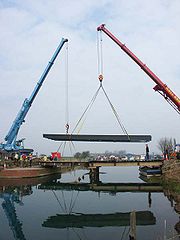
In 2001?, a new steel bridge was built for Brigham Bridge. Unfortunately this was too small for the traffic that needed to go over it, and it sat in the construction yard for the next few years. In March 2003 this bridge was used to replace the complete structure, with a new fixed section decking made from steel, installed by Simpsons Civil Engineering of Driffield
Driffield
Driffield, also known as Great Driffield, is a market town and civil parish in the East Riding of Yorkshire, England. The civil parish is formed by the town of Driffield and the village of Little Driffield....
.
Access to the bridge for boaters became a problem after the bridge keeper was no more. There were no bridge moorings below or above the bridge, and often crew would need to be let off on the bridge base. In 2006 a landing stage was constructed by DNAA above the bridge to make it easier to operate.
The shaded waters of the bridge also attract shoals of perch and pike.