

Struncheon Hill Lock
Encyclopedia
Driffield Navigation
The Driffield Navigation is an waterway, through the heart of the Holderness Plain to the market town of Driffield, East Riding of Yorkshire, England. The northern section of it is a canal, and the southern section is part of the River Hull. Construction was authorised in 1767, and it was fully...
in the East Riding of Yorkshire
East Riding of Yorkshire
The East Riding of Yorkshire, or simply East Yorkshire, is a local government district with unitary authority status, and a ceremonial county of England. For ceremonial purposes the county also includes the city of Kingston upon Hull, which is a separate unitary authority...
, England
England
England is a country that is part of the United Kingdom. It shares land borders with Scotland to the north and Wales to the west; the Irish Sea is to the north west, the Celtic Sea to the south west, with the North Sea to the east and the English Channel to the south separating it from continental...
. It improved access to the next section of water during low tide conditions, and is the first lock. It is sometimes known as "Top Hill Low", which is the name of the large pumping station located there.
Location
Near the small hamletHamlet (place)
A hamlet is usually a rural settlement which is too small to be considered a village, though sometimes the word is used for a different sort of community. Historically, when a hamlet became large enough to justify building a church, it was then classified as a village...
of Hempholme
Hempholme
Hempholme is a hamlet in the East Riding of Yorkshire, England, in an area known as Holderness. It is situated approximately north east of Beverley town centre.It lies east of the Driffield Navigation.-Governance:...
, the lock is about 0.75 mile (1 km) south of Bethells Bridge
Bethells Bridge
Bethells Bridge, a swing bridge on the Driffield Navigation in the East Riding of Yorkshire, England. The bridge was built to access land cut off after a new section of canal was made...
. Access can be made by a footpath from Hempholme
Hempholme
Hempholme is a hamlet in the East Riding of Yorkshire, England, in an area known as Holderness. It is situated approximately north east of Beverley town centre.It lies east of the Driffield Navigation.-Governance:...
, or via the waterworks
WaterWorks
WaterWorks is a water park owned by Cedar Fair, located at the back of Kings Dominion in Doswell, Virginia. When it debuted in 1992, it was originally named Hurricane Reef...
at Top Hill Low which is also a nature reserve
Nature reserve
A nature reserve is a protected area of importance for wildlife, flora, fauna or features of geological or other special interest, which is reserved and managed for conservation and to provide special opportunities for study or research...
.
Situated on the Driffield Navigition
- Next Place Upstream: Bethells BridgeBethells BridgeBethells Bridge, a swing bridge on the Driffield Navigation in the East Riding of Yorkshire, England. The bridge was built to access land cut off after a new section of canal was made...
- Next Place Downstream: Wilfholme LandingWilfholme LandingWilfholme Landing is located on the Driffield Navigation in the East Riding of Yorkshire, England. The navigation is still tidal at this point, and is often considered to still be the River Hull, although technically the Navigation starts at the point where the Aike Beck used to join the river, a...
History
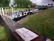
During the navigation improvements of 1803-1811, a new lock cut was made to bypass a large meandering loop of the River Hull around Struncheon Hill.William Chapman, who looked after the works, built the lock to the standard dimensions of the rest of the navigation - to take vessels 60 feet (18.2m) long, by 14 feet 6 inches (4.4m) long. This is a standard known for Yorkshire Keels, however on further investigation it seems the lock was built to longer dimensions and in 2009 Michael Askin took a Royalty Class Narrow Boat Victoria of 71.5 feet (21.5m) in length through the lock - though the boat would only fit pointing upstream due to low water levels not allowing enough depth over the top cill.
Originally made with oak gates, with handspike paddlegear, the top gates were replaced with unusual steel gates by Yorkshire Water, who looked after the navigation for drainage, and water supply. The gates instead of having balance beams to open them, had a complicated rack system which pulled them open with a windlass
Windlass
The windlass is an apparatus for moving heavy weights. Typically, a windlass consists of a horizontal cylinder , which is rotated by the turn of a crank or belt...
. The paddles were designed like weir sluices, and take many turns to open them.
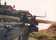
A weir was built at the lock to control the river level. Around the same time the top gates were replaced the weir was replaced by an automatically controlled structure. There is a small building next to the weir which houses water level meter, and control systems for the weir. Originally it had a glass window, and it was possible to look in and see a paper roll on which the level was recorded. It has now been bricked up due to vandalism.
The weir is a noted fishing area, with a resident population of perch, gudgeon and pike.
The bottom gates were replaced in 1982 by the Driffield Navigation Amenities Association with steel ones, but these had balance beams. As a concession to cost, screw style paddles were used.
Just below the lock a steam powered pumping station was built to lift drain water to the river. The steam engine was replaced by diesels at some point, but the boilers were left in the structure. It was finally demolished in the later 1980s