
Barrington, New Hampshire
Encyclopedia
Barrington is a town
in Strafford County
, New Hampshire
, United States
. The population was 8,576 at the 2010 census. The town is a woodland
, farm and bedroom community.
of Barrington Hall, colonial
governor of Massachusetts
and New Hampshire. His brother was John Shute Barrington, 1st Viscount Barrington
.
The town was made up of two grants, the first containing all of Strafford
and present-day Barrington except for a parcel two miles wide called New Portsmouth, or the Two Mile Streak. This second grant had been set aside to provide fuel and home sites for imported workers at the Lamprey River
Iron Works, chartered in 1719 by the Massachusetts General Court
to encourage industrial development in the province.
Slow at first to be settled because of rocky soil, Barrington by 1810 had 3,564 residents, then the state's third largest town, its primary industry the smelting
of iron ore. The Isinglass River
, together with its tributaries, provided water power for grist
, fulling
and saw mills. In 1820, Strafford was set off from Barrington, reducing its land area by about half, because of lengthy travel required to attend town meetings.
In 1882, the Reverend Alonzo Hall Quint writes:
Indeed, the town's attractive natural features, including rivers, brooks, waterfalls and not less than 14 ponds, are summarized by the name of a 374 foot (114 meter) summit: Beauty Hill. Barrington is bisected by the Calef Highway
(Route 125), named for a state senator from the 1800s whose family also founded the locally famous general store founded in 1869.
, the town has a total area of 48.5 square miles (125.6 km²), of which 46.6 sq mi (120.7 km²) of it is land and 1.9 sq mi (4.9 km²) is water, comprising 3.98% of the town. Barrington is drained by the Isinglass River
and Bellamy River
. Swains Lake
and Mendum's Pond are in the south. The highest point in town is an unnamed summit near its western border, measuring 610 feet (185.9 m) above sea level
. The highest named summit is Bumfagging Hill, at 601 ft (183.2 m). Barrington lies fully within the Piscataqua River
(Coastal) watershed
.
The commercial center of town is the village of East Barrington, centered on the junction of state routes 9 and 125
.
 As of the census
of 2000, there were 7,475 people, 2,756 households, and 2,075 families residing in the town. The population density
was 160.5 people per square mile (61.9/km²). There were 3,147 housing units at an average density of 67.6 per square mile (26.1/km²). The racial makeup of the town was 98.11% White, 0.25% African American, 0.13% Native American, 0.41% Asian, 0.05% Pacific Islander, 0.23% from other races
, and 0.80% from two or more races. Hispanic or Latino of any race were 0.92% of the population.
There were 2,756 households out of which 38.8% had children under the age of 18 living with them, 64.6% were married couples
living together, 6.5% had a female householder with no husband present, and 24.7% were non-families. 16.9% of all households were made up of individuals and 4.3% had someone living alone who was 65 years of age or older. The average household size was 2.71 and the average family size was 3.07.
 In the town the population was spread out with 27.5% under the age of 18, 5.7% from 18 to 24, 35.1% from 25 to 44, 24.7% from 45 to 64, and 7.0% who were 65 years of age or older. The median age was 37 years. For every 100 females there were 104.1 males. For every 100 females age 18 and over, there were 101.7 males.
The median income for a household in the town was $50,630, and the median income for a family was $56,136. Males had a median income of $39,098 versus $27,956 for females. The per capita income
for the town was $21,012. About 3.6% of families and 5.5% of the population were below the poverty line, including 7.0% of those under age 18 and none of those age 65 or over.
, Coe-Brown Northwood Academy, or St. Thomas Aquinas High School
.
Cocheco Arts & Technology Academy is a charter school
that serves high school students. The school opened in Dover
in January, 2005, and moved to Barrington in the summer of 2006. It is noted for being the first charter school
in New Hampshire
not specifically set up for special-needs or "at-risk" pupils.
New England town
The New England town is the basic unit of local government in each of the six New England states. Without a direct counterpart in most other U.S. states, New England towns are conceptually similar to civil townships in other states, but are incorporated, possessing powers like cities in other...
in Strafford County
Strafford County, New Hampshire
-Demographics:As of the census of 2000, there were 112,233 people, 42,581 households, and 27,762 families residing in the county. The population density was 304 people per square mile . There were 45,539 housing units at an average density of 124 per square mile...
, New Hampshire
New Hampshire
New Hampshire is a state in the New England region of the northeastern United States of America. The state was named after the southern English county of Hampshire. It is bordered by Massachusetts to the south, Vermont to the west, Maine and the Atlantic Ocean to the east, and the Canadian...
, United States
United States
The United States of America is a federal constitutional republic comprising fifty states and a federal district...
. The population was 8,576 at the 2010 census. The town is a woodland
Woodland
Ecologically, a woodland is a low-density forest forming open habitats with plenty of sunlight and limited shade. Woodlands may support an understory of shrubs and herbaceous plants including grasses. Woodland may form a transition to shrubland under drier conditions or during early stages of...
, farm and bedroom community.
History
Barrington was incorporated in 1722 and named for Samuel ShuteSamuel Shute
Samuel Shute was a military officer and royal governor of the Province of Massachusetts Bay. After serving in the Nine Years' War and the War of the Spanish Succession, he was appointed by King George I as governor of Massachusetts in 1716...
of Barrington Hall, colonial
Colony
In politics and history, a colony is a territory under the immediate political control of a state. For colonies in antiquity, city-states would often found their own colonies. Some colonies were historically countries, while others were territories without definite statehood from their inception....
governor of Massachusetts
Massachusetts
The Commonwealth of Massachusetts is a state in the New England region of the northeastern United States of America. It is bordered by Rhode Island and Connecticut to the south, New York to the west, and Vermont and New Hampshire to the north; at its east lies the Atlantic Ocean. As of the 2010...
and New Hampshire. His brother was John Shute Barrington, 1st Viscount Barrington
John Shute Barrington, 1st Viscount Barrington
John Shute Barrington, 1st Viscount Barrington was an English lawyer and theologian-Background and education:Born at Theobalds House, near Cheshunt in Hertfordshire, he was the son of the merchant, Benjamin Shute...
.
The town was made up of two grants, the first containing all of Strafford
Strafford, New Hampshire
Strafford is a town in Strafford County, New Hampshire, United States. The population was 3,991 at the 2010 census. The two main settlements in town are the villages of Center Strafford and Bow Lake Village.- History :...
and present-day Barrington except for a parcel two miles wide called New Portsmouth, or the Two Mile Streak. This second grant had been set aside to provide fuel and home sites for imported workers at the Lamprey River
Lamprey River
The Lamprey River is a 50.2 mile long river in southeastern New Hampshire, the United States. It rises in Meadow Lake in Northwood, and flows south, then generally east past Raymond, Epping, Lee and finally Newmarket...
Iron Works, chartered in 1719 by the Massachusetts General Court
Massachusetts General Court
The Massachusetts General Court is the state legislature of the Commonwealth of Massachusetts. The name "General Court" is a hold-over from the Colonial Era, when this body also sat in judgment of judicial appeals cases...
to encourage industrial development in the province.
Slow at first to be settled because of rocky soil, Barrington by 1810 had 3,564 residents, then the state's third largest town, its primary industry the smelting
Smelting
Smelting is a form of extractive metallurgy; its main use is to produce a metal from its ore. This includes iron extraction from iron ore, and copper extraction and other base metals from their ores...
of iron ore. The Isinglass River
Isinglass River
The Isinglass River in Strafford County, southeastern New Hampshire, the United States, is about 15 miles long. It rises at Bow Lake in Strafford, but is also fed through its tributaries by Ayer's, Nippo, Round and Long Ponds in Barrington. The Isinglass flows east to meet the Cochecho River below...
, together with its tributaries, provided water power for grist
Gristmill
The terms gristmill or grist mill can refer either to a building in which grain is ground into flour, or to the grinding mechanism itself.- Early history :...
, fulling
Fulling
Fulling or tucking or walking is a step in woolen clothmaking which involves the cleansing of cloth to eliminate oils, dirt, and other impurities, and making it thicker. The worker who does the job is a fuller, tucker, or walker...
and saw mills. In 1820, Strafford was set off from Barrington, reducing its land area by about half, because of lengthy travel required to attend town meetings.
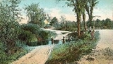
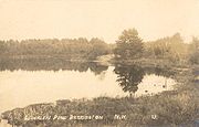
In 1882, the Reverend Alonzo Hall Quint writes:
- "Of those towns in the state whose scenery is somewhat quiet, one of the most beautiful is Barrington."
Indeed, the town's attractive natural features, including rivers, brooks, waterfalls and not less than 14 ponds, are summarized by the name of a 374 foot (114 meter) summit: Beauty Hill. Barrington is bisected by the Calef Highway
New Hampshire Route 125
New Hampshire Route 125 is a long north–south state highway in Rockingham and Strafford counties in southeastern New Hampshire. It runs from Plaistow to just north of Milton...
(Route 125), named for a state senator from the 1800s whose family also founded the locally famous general store founded in 1869.
Notable inhabitants
- John BuzzellJohn BuzzellJohn Buzzell was an early proponent of the Free Will Baptist Church, a Christian author, and a preacher.John Buzzell was born in Barrington, New Hampshire in 1766. After befriending Benjamin Randall, Buzzell became a Free Will Baptist and was ordained a minister in 1792. He preached extensively...
, early Free Will Baptist preacher and writer - Frank Jones, alemaker, hotelier & congressman
- Jillian WheelerJillian WheelerJillian Lee Wheeler is an American singer-songwriter and actress currently residing in Windham, New Hampshire. She is most notable for portraying Sara Markum in the 2003 film, Mystic River...
, singer-singwriter & actress
Geography
According to the United States Census BureauUnited States Census Bureau
The United States Census Bureau is the government agency that is responsible for the United States Census. It also gathers other national demographic and economic data...
, the town has a total area of 48.5 square miles (125.6 km²), of which 46.6 sq mi (120.7 km²) of it is land and 1.9 sq mi (4.9 km²) is water, comprising 3.98% of the town. Barrington is drained by the Isinglass River
Isinglass River
The Isinglass River in Strafford County, southeastern New Hampshire, the United States, is about 15 miles long. It rises at Bow Lake in Strafford, but is also fed through its tributaries by Ayer's, Nippo, Round and Long Ponds in Barrington. The Isinglass flows east to meet the Cochecho River below...
and Bellamy River
Bellamy River
The Bellamy River, in Strafford County, southeastern New Hampshire, is a tributary of the Piscataqua River about long. It rises in Swains Lake in Barrington, west of Dover...
. Swains Lake
Swains Lake
Swains Lake is a water body located in Strafford County in eastern New Hampshire, in the town of Barrington. Water from Swains Lake flows via the Bellamy River to the Piscataqua River estuary....
and Mendum's Pond are in the south. The highest point in town is an unnamed summit near its western border, measuring 610 feet (185.9 m) above sea level
Sea level
Mean sea level is a measure of the average height of the ocean's surface ; used as a standard in reckoning land elevation...
. The highest named summit is Bumfagging Hill, at 601 ft (183.2 m). Barrington lies fully within the Piscataqua River
Piscataqua River
The Piscataqua River, in the northeastern United States, is a long tidal estuary formed by the confluence of the Salmon Falls and Cocheco rivers...
(Coastal) watershed
Drainage basin
A drainage basin is an extent or an area of land where surface water from rain and melting snow or ice converges to a single point, usually the exit of the basin, where the waters join another waterbody, such as a river, lake, reservoir, estuary, wetland, sea, or ocean...
.
The commercial center of town is the village of East Barrington, centered on the junction of state routes 9 and 125
New Hampshire Route 125
New Hampshire Route 125 is a long north–south state highway in Rockingham and Strafford counties in southeastern New Hampshire. It runs from Plaistow to just north of Milton...
.
Demographics
Census
A census is the procedure of systematically acquiring and recording information about the members of a given population. It is a regularly occurring and official count of a particular population. The term is used mostly in connection with national population and housing censuses; other common...
of 2000, there were 7,475 people, 2,756 households, and 2,075 families residing in the town. The population density
Population density
Population density is a measurement of population per unit area or unit volume. It is frequently applied to living organisms, and particularly to humans...
was 160.5 people per square mile (61.9/km²). There were 3,147 housing units at an average density of 67.6 per square mile (26.1/km²). The racial makeup of the town was 98.11% White, 0.25% African American, 0.13% Native American, 0.41% Asian, 0.05% Pacific Islander, 0.23% from other races
Race (United States Census)
Race and ethnicity in the United States Census, as defined by the Federal Office of Management and Budget and the United States Census Bureau, are self-identification data items in which residents choose the race or races with which they most closely identify, and indicate whether or not they are...
, and 0.80% from two or more races. Hispanic or Latino of any race were 0.92% of the population.
There were 2,756 households out of which 38.8% had children under the age of 18 living with them, 64.6% were married couples
Marriage
Marriage is a social union or legal contract between people that creates kinship. It is an institution in which interpersonal relationships, usually intimate and sexual, are acknowledged in a variety of ways, depending on the culture or subculture in which it is found...
living together, 6.5% had a female householder with no husband present, and 24.7% were non-families. 16.9% of all households were made up of individuals and 4.3% had someone living alone who was 65 years of age or older. The average household size was 2.71 and the average family size was 3.07.
The median income for a household in the town was $50,630, and the median income for a family was $56,136. Males had a median income of $39,098 versus $27,956 for females. The per capita income
Per capita income
Per capita income or income per person is a measure of mean income within an economic aggregate, such as a country or city. It is calculated by taking a measure of all sources of income in the aggregate and dividing it by the total population...
for the town was $21,012. About 3.6% of families and 5.5% of the population were below the poverty line, including 7.0% of those under age 18 and none of those age 65 or over.
Education
The Barrington School District serves town children from kindergarten through grade 8, at the Barrington Elementary School and the Barrington Middle School. Students of high school age go to schools in neighboring communities, either Dover High SchoolDover High School (New Hampshire)
Dover Senior High School serves the city of Dover and the towns of Barrington and Nottingham, New Hampshire.In 2005, DHS became a New Hampshire School of Excellence....
, Coe-Brown Northwood Academy, or St. Thomas Aquinas High School
St. Thomas Aquinas High School (Dover, New Hampshire)
St. Thomas Aquinas High School is a coeducational Catholic high school in Dover, New Hampshire, in the Roman Catholic Diocese of Manchester. It has a student population of approximately 650, and a faculty of 55.- History :...
.
Cocheco Arts & Technology Academy is a charter school
Charter school
Charter schools are primary or secondary schools that receive public money but are not subject to some of the rules, regulations, and statutes that apply to other public schools in exchange for some type of accountability for producing certain results, which are set forth in each school's charter...
that serves high school students. The school opened in Dover
Dover, New Hampshire
Dover is a city in Strafford County, New Hampshire, in the United States of America. The population was 29,987 at the 2010 census, the largest in the New Hampshire Seacoast region...
in January, 2005, and moved to Barrington in the summer of 2006. It is noted for being the first charter school
Charter school
Charter schools are primary or secondary schools that receive public money but are not subject to some of the rules, regulations, and statutes that apply to other public schools in exchange for some type of accountability for producing certain results, which are set forth in each school's charter...
in New Hampshire
New Hampshire
New Hampshire is a state in the New England region of the northeastern United States of America. The state was named after the southern English county of Hampshire. It is bordered by Massachusetts to the south, Vermont to the west, Maine and the Atlantic Ocean to the east, and the Canadian...
not specifically set up for special-needs or "at-risk" pupils.
Site of interest
Further reading
- Rev. Alonzo Hall Quint, "Daniel Hall," Sketches of Successful New Hampshire Men, 1882, Published by John Badger Clarke, Manchester, New Hampshire