

Bamingui-Bangoran National Park and Biosphere Reserve
Encyclopedia
The Bamingui-Bangoran National Park complex is a national park
and biosphere reserve
located in the northern region of the Central African Republic
. It makes up part of the Guinea-Congo Forest biome. It was established in 1993. The Vassako Bolo Strict Nature Reserve
is in the midst of the park.
and close to the border with Chad
. Reachable from Bangui
, the capital city, it is situated to the west of Manovo-Gounda St. Floris National Park
, and holds a higher density and a larger number of wild animals than Manovo-Gounda.
The national park is 1,070,000 ha in size, and lies within the mid-Sudanian phytogeographic domain of the Central African Republic. The park is situated on a plateau at an elevation of 400 metres (1,312.3 ft) to 500 metres (1,640.4 ft) above sea level
. Its waterways drain north-westwards to the Chari River
. The left bank floodplain
of the Bamingui River is protected for 202 kilometres (125.5 mi) as are 105 kilometres (65.2 mi) of floodplain on the Bangoran River. A relatively small section, approximately 30 kilometres (18.6 mi) section on the Bangoran's right bank, is excluded from protection.
The climate includes a rainy season of May–October in the southern reaches while diminishing to June–September in the northern areas. It can be muggy all year.
is characterized as tropical dry or deciduous forests while the major habitats and land covers are dry forest
s, wooded savanna
s, edaphic
savannas, and gallery forest
s. Trees include the Terminalia, Isoberlinia doka and Anogeissus.
 The sub-specific endemism seen in the large mammals appears to link to Chari-Logone River system Pleistocene
isolation. One mammal is considered endangered
, the African wild dog, while the cheetah, lion, and African manatee are classified as vulnerable. According to Spinage, antelope
populations have declined markedly since 1960 within the park.
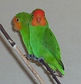
The park reserve's amphibians include the Mascarene ridged frog, sharp-nosed ridged frog, Schilluk ridged frog, Galam white-lipped frog, Cryptic sand frog, Ornate frog, Crowned bullfrog, flat-backed toad, Shovel-nosed frog, Senegal kassina, and Natal puddle frog. The Red Faced Lovebird
is found here and in Nigeria
's Gashaka Gumti National Park
.
National park
A national park is a reserve of natural, semi-natural, or developed land that a sovereign state declares or owns. Although individual nations designate their own national parks differently A national park is a reserve of natural, semi-natural, or developed land that a sovereign state declares or...
and biosphere reserve
Biosphere reserve
The Man and the Biosphere Programme of UNESCO was established in 1971 to promote interdisciplinary approaches to management, research and education in ecosystem conservation and sustainable use of natural resources.-Development:...
located in the northern region of the Central African Republic
Central African Republic
The Central African Republic , is a landlocked country in Central Africa. It borders Chad in the north, Sudan in the north east, South Sudan in the east, the Democratic Republic of the Congo and the Republic of the Congo in the south, and Cameroon in the west. The CAR covers a land area of about ,...
. It makes up part of the Guinea-Congo Forest biome. It was established in 1993. The Vassako Bolo Strict Nature Reserve
Vassako Bolo Strict Nature Reserve
The Vassako Bolo Strict Nature Reserve is an 86,000 ha nature reserve within Bamingui-Bangoran National Park and Biosphere Reserve in the northern region of the Central African Republic. It is located near the town of N'Délé, Sangha-Mbaéré prefecture. It was gazetted in 1960.-References:...
is in the midst of the park.
Geography
The park and biosphere reserve complex is located in the country's centre-north, west of N'DéléN'Délé
N'Délé or Ndele is a market town and sub prefecture in the north eastern Central African Republic, lying east of the Bamingui-Bangoran National Park. Ndélé is the capital of Bamingui-Bangoran, one of the 14 prefectures of the Central African Republic....
and close to the border with Chad
Chad
Chad , officially known as the Republic of Chad, is a landlocked country in Central Africa. It is bordered by Libya to the north, Sudan to the east, the Central African Republic to the south, Cameroon and Nigeria to the southwest, and Niger to the west...
. Reachable from Bangui
Bangui
-Law and government:Bangui is an autonomous commune of the Central African Republic. With an area of 67 km², it is by far the smallest high-level administrative division of the CAR in area but the highest in population...
, the capital city, it is situated to the west of Manovo-Gounda St. Floris National Park
Manovo-Gounda St. Floris National Park
Manovo-Gounda St.Floris National Park is a national park and UNESCO World Heritage Site located in the Central African Republic prefecture Bamingui-Bangoran, near the Chad border. It was inscribed to the list of World Heritage Sites in 1988 as a result of the diversity of life present within it...
, and holds a higher density and a larger number of wild animals than Manovo-Gounda.
The national park is 1,070,000 ha in size, and lies within the mid-Sudanian phytogeographic domain of the Central African Republic. The park is situated on a plateau at an elevation of 400 metres (1,312.3 ft) to 500 metres (1,640.4 ft) above sea level
Above mean sea level
The term above mean sea level refers to the elevation or altitude of any object, relative to the average sea level datum. AMSL is used extensively in radio by engineers to determine the coverage area a station will be able to reach...
. Its waterways drain north-westwards to the Chari River
Chari River
The Chari or Shari River is a 949-kilometer-long river of central Africa. It flows from the Central African Republic through Chad into Lake Chad, following the Cameroon border from N'Djamena, where it joins the Logone River waters....
. The left bank floodplain
Floodplain
A floodplain, or flood plain, is a flat or nearly flat land adjacent a stream or river that stretches from the banks of its channel to the base of the enclosing valley walls and experiences flooding during periods of high discharge...
of the Bamingui River is protected for 202 kilometres (125.5 mi) as are 105 kilometres (65.2 mi) of floodplain on the Bangoran River. A relatively small section, approximately 30 kilometres (18.6 mi) section on the Bangoran's right bank, is excluded from protection.
The climate includes a rainy season of May–October in the southern reaches while diminishing to June–September in the northern areas. It can be muggy all year.
Flora and fauna
Bamingui-Bangoran's major ecosystemEcosystem
An ecosystem is a biological environment consisting of all the organisms living in a particular area, as well as all the nonliving , physical components of the environment with which the organisms interact, such as air, soil, water and sunlight....
is characterized as tropical dry or deciduous forests while the major habitats and land covers are dry forest
Tropical and subtropical dry broadleaf forests
The tropical and subtropical dry broadleaf forest biome, also known as tropical dry forest, is located at tropical and subtropical latitudes. Though these forests occur in climates that are warm year-round, and may receive several hundred centimeters of rain per year, they have long dry seasons...
s, wooded savanna
Savanna
A savanna, or savannah, is a grassland ecosystem characterized by the trees being sufficiently small or widely spaced so that the canopy does not close. The open canopy allows sufficient light to reach the ground to support an unbroken herbaceous layer consisting primarily of C4 grasses.Some...
s, edaphic
Edaphic
Edaphic is a nature related to soil. Edaphic qualities may characterize the soil itself, including drainage, texture, or chemical properties such as pH. Edaphic may also characterize organisms, such as plant communities, where it specifies their relationships with soil...
savannas, and gallery forest
Gallery forest
Gallery forests are evergreen forests that form as corridors along rivers or wetlands and project into landscapes that are otherwise only sparsely treed such as savannas, grasslands or deserts....
s. Trees include the Terminalia, Isoberlinia doka and Anogeissus.
Pleistocene
The Pleistocene is the epoch from 2,588,000 to 11,700 years BP that spans the world's recent period of repeated glaciations. The name pleistocene is derived from the Greek and ....
isolation. One mammal is considered endangered
Endangered species
An endangered species is a population of organisms which is at risk of becoming extinct because it is either few in numbers, or threatened by changing environmental or predation parameters...
, the African wild dog, while the cheetah, lion, and African manatee are classified as vulnerable. According to Spinage, antelope
Antelope
Antelope is a term referring to many even-toed ungulate species indigenous to various regions in Africa and Eurasia. Antelopes comprise a miscellaneous group within the family Bovidae, encompassing those old-world species that are neither cattle, sheep, buffalo, bison, nor goats...
populations have declined markedly since 1960 within the park.
The park reserve's amphibians include the Mascarene ridged frog, sharp-nosed ridged frog, Schilluk ridged frog, Galam white-lipped frog, Cryptic sand frog, Ornate frog, Crowned bullfrog, flat-backed toad, Shovel-nosed frog, Senegal kassina, and Natal puddle frog. The Red Faced Lovebird
Red-headed Lovebird
The Red-headed Lovebird also known as the Red-faced Lovebird is a member of the genus Agapornis, a group commonly known as Lovebirds. Like other lovebirds it is native to Africa.-Description:...
is found here and in Nigeria
Nigeria
Nigeria , officially the Federal Republic of Nigeria, is a federal constitutional republic comprising 36 states and its Federal Capital Territory, Abuja. The country is located in West Africa and shares land borders with the Republic of Benin in the west, Chad and Cameroon in the east, and Niger in...
's Gashaka Gumti National Park
Gashaka Gumti National Park
Gashaka-Gumti National Park is a national park in Nigeria, It was gazetted from two game reserves in 1991 and is Nigeria’s largest national park. The total area covers about 6402 km², much of the northern GGNP is savannah. The southern GGNP sector of the park has rugged terrain from about 300...
.